APPENDIX G
1.0
INTRODUCTION
In Nova Scotia, wetlands are protected by the NSDEL Wetlands Directive. Any loss of wetland requires preparation of a wetland evaluation to establish the value of the wetland in relation to the merits of the development. Wetland evaluations are required if a project will physically disturb a wetland or if the hydrology of the wetland will be altered by construction or operation of the project. Wetlands less than two hectares in size can be evaluated using a ten-step evaluation process used by NSDEL. Wetlands greater than two hectares in size are evaluated using the North American Wetlands Conservation Council (Canada) wetland evaluation technique.
The property boundary for the Bear Head LNG Terminal in Port Hawkesbury encompasses 6 wetlands. Wetland surveys were conducted in all of these wetlands with the exception of Wetland 6 which was not within the study area at the time the field surveys were completed. The wetland surveys were conducted to provide the information required to conduct wetland evaluations for any of these wetlands which may be adversely affected by construction and operation of the terminal. The wetland surveys collected a variety of information including the type of wetland and a description of its hydrology, a description of the wetland habitat types present in the wetland, inventories of vascular plants, birds, mammals, reptiles and amphibians present in the wetland, any evidence of anthropogenic use of the wetland, and any evidence of impacts to the wetland caused by anthropogenic activities. The information collected for each wetland was derived largely from field surveys since there is little existing information for most wetlands in Nova Scotia. Each wetland was visited twice, once in June and again in late July 2003. The sizes and locations of the wetlands were determined from 1:10,000 scale topographic mapping of the Project area and 1:10,000 scale air photography. The topographic mapping was used as the base mapping and the air photos in conjunction with the field surveys were used to more precisely define the boundaries of the wetlands. The location of the wetlands along the RoW are presented in Figure 6.3 in the main portion of the EA report.
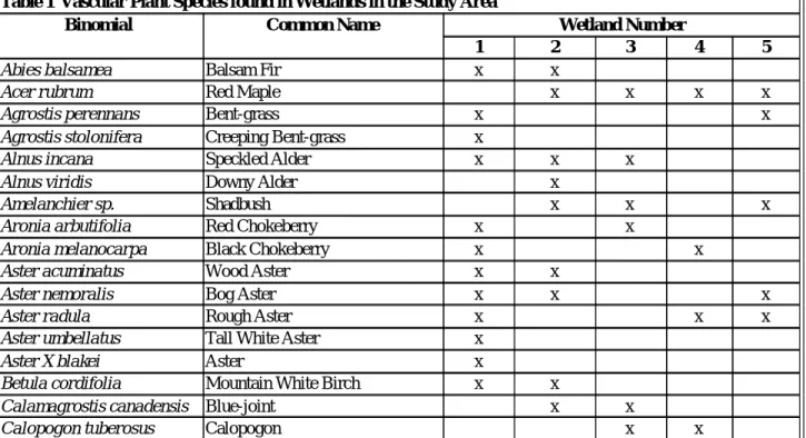
The results of the vascular plant surveys conducted in each wetland are presented in . Wetland evaluations were conducted for the wetlands to be impacted by Project construction. One of the six wetlands evaluated is greater than two hectares in size and was evaluated using the North American Wetlands Conservation Council (Canada) wetland evaluation technique. Two of the remaining four wetlands, which may be affected by Project construction were evaluated using the NSDEL ten-step evaluation process. The wetland evaluations are presented in the following text.
Table 1 Vascular Plant Species found in Wetlands in the Study Area
Binomial Common Name Wetland Number
1 2 3 4 5
Abies balsamea Balsam Fir x x
Acer rubrum Red Maple x x x x
Agrostis perennans Bent-grass x x
Agrostis stolonifera Creeping Bent-grass x
Alnus incana Speckled Alder x x x
Alnus viridis Downy Alder x
Amelanchier sp. Shadbush x x x
Aronia arbutifolia Red Chokeberry x x
Aronia melanocarpa Black Chokeberry x x
Aster acuminatus Wood Aster x x
Aster nemoralis Bog Aster x x x
Aster radula Rough Aster x x x
Aster umbellatus Tall White Aster x
Aster X blakei Aster x
Betula cordifolia Mountain White Birch x x
Calamagrostis canadensis Blue-joint x x
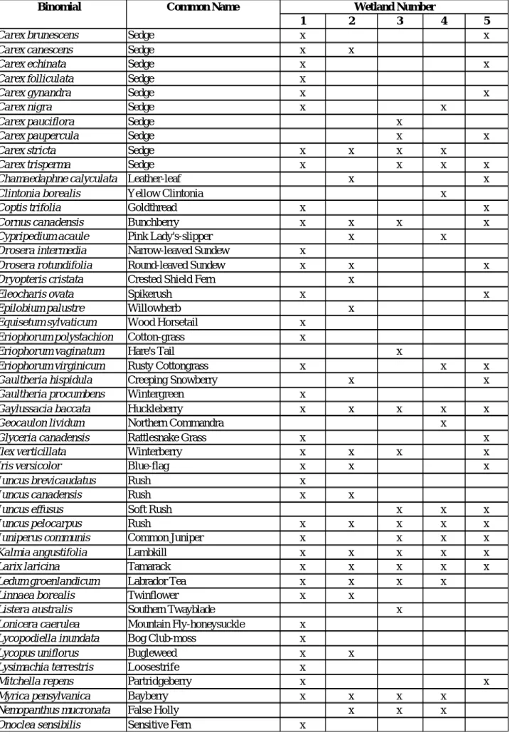
Table 1 Vascular Plant Species found in Wetlands in the Study Area
Binomial Common Name Wetland Number
1 2 3 4 5
Carex brunescens Sedge x x
Carex canescens Sedge x x
Carex echinata Sedge x x
Carex folliculata Sedge x
Carex gynandra Sedge x x
Carex nigra Sedge x x
Carex pauciflora Sedge x
Carex paupercula Sedge x x
Carex stricta Sedge x x x x
Carex trisperma Sedge x x x x
Chamaedaphne calyculata Leather-leaf x x
Clintonia borealis Yellow Clintonia x
Coptis trifolia Goldthread x x
Cornus canadensis Bunchberry x x x x
Cypripedium acaule Pink Lady's-slipper x x
Drosera intermedia Narrow-leaved Sundew x
Drosera rotundifolia Round-leaved Sundew x x x
Dryopteris cristata Crested Shield Fern x
Eleocharis ovata Spikerush x x
Epilobium palustre Willowherb x
Equisetum sylvaticum Wood Horsetail x
Eriophorum polystachion Cotton-grass x
Eriophorum vaginatum Hare's Tail x
Eriophorum virginicum Rusty Cottongrass x x x
Gaultheria hispidula Creeping Snowberry x x
Gaultheria procumbens Wintergreen x
Gaylussacia baccata Huckleberry x x x x x
Geocaulon lividum Northern Commandra x
Glyceria canadensis Rattlesnake Grass x x
Ilex verticillata Winterberry x x x x
Iris versicolor Blue-flag x x x
Juncus brevicaudatus Rush x
Juncus canadensis Rush x x
Juncus effusus Soft Rush x x x
Juncus pelocarpus Rush x x x x x
Juniperus communis Common Juniper x x x x
Kalmia angustifolia Lambkill x x x x x
Larix laricina Tamarack x x x x x
Ledum groenlandicum Labrador Tea x x x x
Linnaea borealis Twinflower x x
Listera australis Southern Twayblade x
Lonicera caerulea Mountain Fly-honeysuckle x
Lycopodiella inundata Bog Club-moss x
Lycopus uniflorus Bugleweed x x
Lysimachia terrestris Loosestrife x
Mitchella repens Partridgeberry x x
Myrica pensylvanica Bayberry x x x x
Table 1 Vascular Plant Species found in Wetlands in the Study Area
Binomial Common Name Wetland Number
1 2 3 4 5
Osmunda cinnamomea Cinnamon Fern x x x x x
Osmunda claytoniana Interupted Fern x
Osmunda regalis Royal Fern x
Phegopteris connectilis Beech Fern x
Picea glauca White Spruce x
Picea mariana Black Spruce x x x x x
Pinus strobus White Pine x x
Platanthera blephariglottis White Fringed Orchid x x x
Platanthera clavellata Northern Club-spur x
Pogonia ophioglossoides Rose Pogonia x
Pteridium aquilinum Bracken Fern x x x
Rhododendron canadense Rhodora x x x
Rhyncospora alba Beak-rush x x
Rosa nitida Swamp Rose x x
Rubus canadensis Blackberry x x
Rubus hispidus Trailing Blackberry x x x x
Rubus pubescens Dewberry x
Rubus setosus Blackberry x x x
Scirpus caespitosus Deer Grass x
Scirpus cyperinus Wool Grass x
Smilacina trifoliata Three-leaved False Solomon's-seal x x
Solidago uliginosa Bog Goldenrod x x
Sparganium americanum Burreed x
Sparganium sp. Burreed x
Thelypteris noveboracensis New York Fern x x x
Thelypteris palustris Marsh-fern x x
Thelypteris simulata Bog Fern x x
Triadenum fraseri Marsh St. John's-wort x x x
Vaccinium angustifolium Late Lowbush Blueberry x x
Vaccinium macrocarpon Large Cranberry x x
Vaccinium mytilloides Canada Blueberry x x
Vaccinium oxycoccus Small Cranberry x x x
Viburnum nudum Witherod x x x x
Viola macloskeyi Small White Violet x x
2.0
NSDEL TEN STEP WETLAND EVALUATIONS
2.1
WETLANDS
Information regarding wetlands within the study area was derived from several sources, including Wetland Atlas-Wetland Protection mapping (Canadian Wildlife Service 1984), 1:10,000 scale topographic mapping, 1:10,000 scale colour air photos, and two site visits for each wetland. Air photos and the Wetland Atlas (CWS 1984) were consulted to identify wetlands in the study area prior to the field surveys. Five wetlands were identified in the study area and evaluated (Figure 6.3). Three of the wetlands are found entirely within the study area while two are partially contained within the study area. The following sections describe each of the five wetlands assessed in the field. Full wetland evaluation are included in (Appendix G). A sixth wetland within the ANEI property was subsequently identified once the property boundary and fenceline were established.
2.2
WETLAND 1
Wetland 1 (Figure 6.3) is 1.87 ha and is a wetland complex composed of slope fen, mixedwood treed spring swamp and coniferous treed basin bog. The wetland supports four distinct plant communities. Treed bog is present at the eastern end of the wetland. The dominant tree species here are tamarack (Larix laricina), black spruce (Picea mariana) and red maple (Acer rubrum). The shrub layer is relatively sparse compared to other treed bogs and is composed mainly of huckleberry (Gaylussacia baccata), witherod (Viburnum nudum), winterberry (Ilex verticillata), red chokeberry (Aronia arbutifolia), and speckled alder (Alnus incana). The ground vegetation consists mostly of sphagnum moss (Sphagnum spp.), cinnamon fern (Osmunda cinnamomea), bunchberry (Cornus canadensis), and cottongrass (Eriophorum virginicum). The low tree and shrub cover in this community is attributable to past beaver flooding which caused heavy mortality of tree and shrub species.
This wetland is the headwaters of a small stream which passes through the treed bog. The banks of the stream support a plant community dominated by a mixture of sphagnum moss, burreed (Sparganium americanum), narrow-leaved sundew (Dosera intermedia), beakrush (Rhyncospora alba), and swamp candles (Lysimachia terrestris). There are no tree or shrub species associated with this plant community.
A long arm of wetland habitat extends from the western side of the wetland. This arm supports two plant communities. At the tip of the arm is a slope fen habitat which is characterized a relatively dense sward of grasses and sedges. The most abundant species of the ground vegetation layer include sedges (Carex stricta, C. nigra, and C. canescens), sphagnum moss, blue-joint (Calamagrostis canadensis), creeping bent-grass (Agostis stolonifera), and swamp candles. Tree cover consists of scattered stunted red maple and tamarack. The shrub layer is also sparse and consists mainly of trailing blackberry (Rubus hispidus) and winterberry.
Proceeding along the arm of wetland habitat from west to east, slope fen habitat gives way to mixedwood treed slope spring swamp. A relatively dense cover of immature trees and shrubs characterizes the spring swamp plant community. The most abundant tree species are red maple, tamarack, black spruce and white pine. Common shrub species include winterberry, speckled alder and huckleberry. The ground vegetation layer consists mainly of sphagnum moss, cinnamon fern and bunchberry.
2.2.1
Step 1 Evaluate Wildlife Habitat Potential
The wetland has not been mapped on the Wetlands Atlas for Nova Scotia so no Golet score (a wetland evaluation system used to determine the value of wetlands as wildlife habitat) is available for the wetland. During the field survey all species of bird, mammal, reptile and amphibian detected within the wetland were recorded. Wildlife species were detected on the basis of visual sightings, vocalizations, tracks, faeces, skeletal remains, and distinctive spoor such as characteristic bite marks or dens.
During the field survey fourteen bird species were recorded in or adjacent to the wetland. These included: American Goldfinch, White-throated Sparrow, Northern Junco, Common Yellowthroat, Black-capped Chickadee, American Robin, Yellow-rumped Warbler, Nashville Warbler, Yellow-bellied Flycatcher, Magnolia Warbler, Swamp Sparrow, Purple Finch, Golden-crowned Kinglet, and Blue Jay. It is likely that five of these species breed in the wetland. These include: White-throated Sparrow, Northern Junco, Common Yellowthroat, Yellow-bellied Flycatcher, and Swamp Sparrow. No mammals were detected in the wetland during the field surveys. The presence of the remnants of a beaver dam at the outflow of the wetland indicates that beaver once occupied the wetland. Herpetiles found in the wetland included green frog, leopard frog, pickerel frog, and northern spring peeper. The wetland provides suitable breeding habitat for all of these species. The results of the field survey suggest that the wetland does not provide significant wildlife habitat. The mixedwood treed swamp and coniferous treed bog habitats that occupies most of the wetland are common wetland types in the area, so this particular wetland does not provide a unique habitat type.
2.2.2
Step 2 Evaluate for Rare and Endangered Species
The wetland has relatively high potential to provide breeding habitat for four-toed salamanders, an uncommon amphibian species. The four-toed salamander is listed as a yellow species by NSDNR indicating that it is sensitive to human activities (NSDNR 2003a). Nova Scotian herpetologists believe that the four-toed salamander is more widespread and abundant than records indicate due to the cryptic nature of this species and the fact that it occupies habitats where humans tend to avoid. Suitable breeding habitat (sphagnum moss hummocks adjacent to pools) was present at the eastern end of the wetland however, no four-toed salamanders were detected during the June survey which coincides with the nesting season for this species. Four-four-toed salamanders are most easily detected during the time when females are guarding their eggs (May and June). Well developed sphagnum moss hummocks are most frequently used as nest sites by four-toed salamanders. The sphagnum hummocks in Wetland 1 were low suggesting that this habitat is sub-optimal. Wetland 1 is the headwaters of a small stream. No fish were observed in the stream during any of the field surveys.
A vegetation survey was conducted in the wetland to determine if any rare vascular plants were present. A total of 72 species were found in the wetland, none of which is considered to be rare in Nova Scotia (NSDNR 2003a; NSDNR 2003b) or Canada (COSEWIC 2003).
2.2.3
Step 3 Evaluate Groundwater Recharge Potential
The wetland is characterised by the presence of an outflow stream but no inflow stream. This would suggest that the wetland is a groundwater discharge site rather than a groundwater recharge site.
2.2.4
Step 4 Evaluate the Role of the Wetland in Surface Flow Regulation
The wetland is located at the extreme upper reach of a small unnamed stream so it is not expected to play any role in flood control. The wetland can be expected to contribute to augmentation of stream flow during low flow periods. However, given the small size of the wetland and the short length of the stream (500 m from the wetland to the sea) the role of the wetland in surface water flow regulation is not significant.
2.2.5
Step 5 Evaluate the Agricultural Use of the Wetland
The wetland is not used for agricultural production and has no potential to be used for agricultural production.
2.2.6
Step 6 Evaluate the Potential Role of the Wetland in Water Treatment
2.2.7
Step 7 Evaluate the Potential for Peat Development
The wetland is too small to provide an economically viable peat harvesting operation. In addition, the treed bog and mixedwood treed swamp habitats produce a woody peat which has low value as a soil amendment.
2.2.8
Step 8 Have you Addressed all Potential Issues with the Wetland Proposal?
All potential issues have been addressed.2.2.9
Step 9 Address Additional Concerns
There are no additional concerns.2.2.10 Step 10 Summary of Wetland Evaluation
Overall, this wetland is not considered to be significant. It has limited value as wildlife habitat due to its small size and the fact that it is composed of common habitat types. The wetland may provide suitable breeding habitat for four-toed salamanders. No four-toed salamanders were found during the survey and the portion of the wetland that contains suitable nesting habitat will not be affected by construction activity. The wetland has no potential for agricultural production or peat development and plays no significant role in the hydrology of the area.
2.3
WETLAND 5
This wetland is only 0.1 ha in size and is located near the western tip of Wetland 1. It is classified as a coniferous treed slope bog. Tree cover in this wetland is sparse and patchy consisting of a mixture of black spruce, tamarack and red maple. There is little shrub cover, which consists largely of huckleberry and winterberry. The surface of the bog consists of a continuous sphagnum moss carpet that is punctuated by patches of cinnamon fern, New York fern (Thelypteris noveboracensis), bunchberry (Cornus canadensis), and cotton-grass.
2.3.1
Step 1 Evaluate Wildlife Habitat Potential
The wetland has not been mapped on the Wetlands Atlas for Nova Scotia so no Golet score is available for the wetland. No birds, mammals or herpetiles were recorded from the wetland during the field surveys. This was not unexpected given the small size of the wetland and the lack of open water wetland. The wetland is not large enough to provide suitable habitat for vertebrate species characteristic of wetland habitats. Instead, birds mammals and herpetiles characteristic of the surrounding woodland habitats have integrated the wetland into their territories. The wetland is very similar in structure and species composition to the coniferous forest habitat that surrounds it. Overall, the wetland has low value as wildlife habitat.
2.3.2
Step 2 Evaluate for Rare and Endangered Species
No birds, mammals, reptiles or amphibians were detected in the wetland during the site visits. A vegetation survey conducted in the wetland revealed the presence of 37 species of vascular plant, none of which is considered to be rare in Nova Scotia (Pronych and Wilson 1993; ACCDC 2003; NSDNR 2003a) (Table 1).
2.3.3
Step 3 Evaluate Groundwater Recharge Potential
The wetland is located on a gentle slope and seepage was present on the downslope side of the wetland which would indicate that the wetland is a groundwater discharge site rather than a groundwater recharge site.
2.3.4
Step 4 Evaluate the Role of the Wetland in Surface Flow Regulation
The wetland is not located along a stream or river, consequently, it is not expected to play a role in flood control. The retention of surface water and groundwater flow would help to even out flow in receiving watercourses down slope of the wetland. However, given the very small size of this wetland and the proximity of the wetland to the sea, the wetland is not expected to play a significant role in surface flow regulation. It is not anticipated that the construction of the LNG terminal will physically disturb the wetland so this function should persist. However, changes in soil permeability and surface and groundwater flow patterns associated with construction of the terminal could affect the amount of water moving through the wetland.
2.3.5
Step 5 Evaluate the Agricultural Use of the Wetland
The wetland is not used for agricultural production and has no potential to be used for agricultural production.
2.3.6
Step 6 Evaluate the Potential Role of the Wetland in Water Treatment
The wetland currently provides no function in water treatment due to lack of nearby development.2.3.7
Step 7 Evaluate the Potential for Peat Development
The peat in this wetland is less than one metre in depth. This combined with the very small size of the wetland would make it unsuitable for peat harvesting.
2.3.8
Step 8 Have you Addressed all Potential Issues with the Wetland Proposal?
All potential issues have been addressed.2.3.9
Step 9 Address Additional Concerns
There are no additional concerns.2.3.10 Step 10 Summary of Wetland Evaluation
Overall, this wetland is not considered to be significant. It is very small and does not provide unique habitat for plants or animals. It has limited value as wildlife habitat due to its small size. No rare or endangered species were encountered in the wetland. The wetland has no potential for agricultural production or peat development nor does it play a significant role in the hydrology of the area.
3.0
NORTH AMERICAN WETLAND EVALUATIONS
3.1
Wetland 2
3.1.1
Process
3.1.1.1 Background
Name Jacques Whitford Environment Limited
Address 3 Spectacle Lake Drive, Dartmouth, Nova Scotia B3B 1W8
Date March 01, 2004
3.1.1.2 Project
This section describes the proposed project. It is essential that the project be described before proceeding with this section.
a. Summary of Project (fill in and check the boxes)
Name of Project Bear Head LNG Terminal Port Hawkesbury
i. Is it a public or private project? 9 Public: Private
ii. Does it require land use approval? 9 Yes : No
iii. Where is it located? Bear Head, Richmond County, Nova Scotia
iv. Is it proposed in or near a wetland? 9 In : Near
v. Will the wetland be fully or partially drained? 9 Fully 9 Partially
fully or partially dredged? 9 Fully 9 Partially
completely or partially filled? 9 Completely : Partially
fully or partially dyked? 9 Fully 9 Partially (Temporarily)
fully or partially flooded? 9 Fully 9 Partially
fully or partially enhanced/restored? 9 Fully 9 Partially Other
b. Type of Activity Proposed (check appropriate boxes; if necessary describe under “other”)
i. : Industrial ii. 9 Commercial iii. 9 Residential iv. 9 Institutional v. 9 Recreational/Tourism vi. 9 Agriculture
vii. 9 Transportation/Utility Corridor
viii. 9 Habitat Development
ix. 9 Forestry
x. 9 Other (describe)
xi. Statement of Project Purpose To construct a Liquefied Natural Gas (LNG) receiving terminal to provide a stable natural gas supply to Atlantic Canada and the northeastern US.
xii. Precise Description of Activity Construction of the LNG terminal, including the marine jetty on a 65 ha property.
c. Status of Project (land use controls which might affect the project) i. Jurisdiction of Approving Authority
: Federal
: Territorial/Provincial 9 Municipal/Regional 9 Native
ii. Type of Mandatory Review
Mandatory review required?
: Yes 9 No
Environmental Impact Assessment required?
: Yes 9 No Federal
: Yes 9 No Territorial/Provincial
9 Yes : No Municipal
9 Yes : No Native
iii. Does the project fall under Municipal Development Control? (If yes continue, if no go to “iv”) Type of Control:
9 Approved Development Plan : Approved Zoning By-Law
9 Approved Environmental Impact Assessment (EIA) 9 Approved Performance Standards
9 Other (described) iv. Status of Proposal
9 Not Submitted : Under Review 9 Approved 9 Denied 9 Under Appeal 9 Requires Zoning
v. Sources of Funding (check one or more) : Private Financing
9 Public Financing 9 Public Subsidy
If public subsidy, please name program
vi. Level of Project Understanding/Refinement (check one)
9 At very preliminary stage; little or no economic cost/benefit analysis
: Preliminary stage; conceptual drawings, economic cost/benefit analysis, environmental impact considerations
9 Detailed design; design drawings, cost/benefit analysis (all components), and Environmental Impact Assessment
vii. Potential for Stewardship
Stewardship represents landowner commitment to manage the wetland in society’s interest. Does that potential exist for this wetland?
9 Yes : No 9 Maybe
If yes or maybe, what steps are needed to institute a stewardship program?
d. Project Production Summary
This section examines the products (i.e. benefits and disbenefits) which the project might generate.
i. Has an economic analysis been completed for the project?
: Yes (continue to “ii”) 9 No (go to “iv”)
If yes, by whom: 9 by proponent in-house : by professional consultant
9 other (name/agency/organization) Information about analyst
Name Kent Gustavson Jacques Whitford Environment Ltd.
Address 3 Spectacle Lake Drive Dartmouth, NS
Telephone No. 902-468-7777
Date Analysis Prepared August 2003
ii. Status of Economic Findings (evaluator’s opinion only) 9 Detailed, thorough economic findings
: Preliminary economic findings 9 No economic findings (go to “iv”) 9 Information not available (g to “iv”)
iii.Summary of Findings/Project Benefits (if no estimates, check box; if estimates are available indicate information on line provided)
9 Permanent jobs (person/years) 32-40
9 Permanent contribution to new area wages per year 2.2-2.8 million : Permanent contribution to new area spending (total per year) 9 Construction jobs (person/years) 1,600 person years : Construction contribution to new area wages per year : Construction contribution to area spending (total per year) : Increased production by type (e.g. agriculture, forestry, tourism) : Other benefits
: Amenity Contribution
iv. Summary of Potential Disbenefits (check the appropriate boxes)
There are expected problems that may occur because of the project. These potential problems are the preliminary issues that will need to be addressed as part of the project review.
: Noise 9 Water drawdown 9 Recreational loss
e. Summary of Expected Level of Selected Project Impacts (check box for high, moderate, or low)
The following table provides project information which will assist in subsequent considerations of potential project impact upon the wetland under review. This table summarizes the evaluator’s views based upon existing known information.
LEVEL OF EXPECTED IMPACT
POTENTIAL
WETLAND IMPACTS HIGH MODERATE LOW
Noise Pollution T Air Pollution T Water Pollution T Water Drawdown T Habitat Loss T Aesthetic Loss T Recreational Loss T Other LEVEL OF EXPECTED IMPACT POTENTIAL
ECONOMIC IMPACTS HIGH MODERATE LOW
Employment T Training T Construction Spending T Operation Spending T Taxes T Indirect Spending* T Flood Protection T Other T * (e.g. Tourism)
f. Project Summary (project description, sources, and a summary of findings that may be useful in future analysis) A project description and analysis of environmental effects is presented in the “Bear Head LNG Terminal Environmental Assessment Report” prepared for Access Northeast Energy Inc. by Jacques Whitford Environment Limited
3.1.1.3 Wetland Description
This section describes the affected wetland. It is essential that the wetland be described before proceeding.
a. Wetland Location
Province/Territory Nova Scotia
Common Place Name (if any) Bear Head
Nearest Urban Centre Port Hawkesbury
Legal Description (if any) None
Land Description:9 Public : Private 9 Protected Area 9 Other
If public, name of area/site (if any) If protected, name of agency and status
b. Map
Show location of wetland and proposed project in relation to region. (Draw or place map here, or attach map and/or project plan to back of this page. Indicate direction of north and ensure that map contains a scale).
(See Figure 6.3).
c. Wetland Context
This provides a brief description of the wetland and preliminary relationship to the project.
i. Wetland Complexity Size
Is this a single wetland 9 Yes : No ha ( ) acres
Is this a wetland complex* : Yes 9 No 3.8 ha ( 9.3 ) acres
(*i.e. a series of more than one wetland)
ii. Wetland Class
a) Single Wetland
(Check one only)
b) Wetland Complex
(Check all classes present, and write number if it occurs more than once)
c) Wetland Classification
9 Bog 9 Bog 9 Temporary
9 Fen 9 Fen 9 Seasonal
9 Swamp : Swamp Three types :Permanent
9 Marsh 9 Marsh
iii.Has this wetland been previously impacted?
: Yes 9 No
If yes, describe
The wetland receives drainage from a coal ash disposal site located approximately 500 m west of the wetland.
Additional Comments Regarding Wetland Description
Wetland 2 is located on a small stream located west of the project footprint. It is 3.8 ha in size and is a wetland complex composed of mixedwood treed stream swamp, coniferous treed stream swamp and tall shrub dominated stream swamp.
There are three distinct plant communities present in this wetland. The largest plant community is the tall shrub swamp community which occupies the center of the wetland. This community is dominated by a mixture of tall and low shrub species, the most abundant of which are speckled alder (Alnus inacana), winterberry (Ilex verticillata), huckleberry (Gaylussacia baccata), lambkill (Kalmia angustifolia), and witherod (Viburnum nudum). Tree cover is sparse and consists mainly of red maple and black spruce (Picea mariana). Sphagnum moss and sedge (Carex stricta) are the most abundant ground vegetation species. Bog fern (Thelypteris simulata), cinnamon fern (Osmunda cinnamomea) and marsh St. John’s-wort (Triadenum fraseri) are also common species of the ground vegetation layer.
Mixedwood treed swamp is found around the margin of the wetland. This community is similar in species composition to the tall shrub swamp community and represents a later stage in plant community succession in the wetland. The tree layer is open but much better developed than in the tall shrub swamp community. Red maple and black spruce are the dominant tree species along with small amounts of mountain white birch (Betula cordifolia). The shrub layers consist mainly of speckled alder and young trees. The ground vegetation layer consists of a mixture of sphagnum moss, sedge (Carex stricta), bog fern, and cinnamon fern.
Coniferous treed stream swamp occupies a small area at the eastern end of the wetland. The tree canopy is relatively well developed and is composed mainly of tamarack (Larix laricina) along with a few red maple and black spruce. The shrub layer consists of a mixture of shrubs and advanced tree regeneration. The most abundant species of the shrub layer include black spruce, lambkill, huckleberry, winterberry, speckled alder, and witherod. The most abundant ground vegetation species include sphagnum moss, sedge (Carex stricta), cinnamon fern, and bog aster (Aster nemoralis).
Snags are common in the wetland indicating that there has been heavy tree mortality within the past few decades. This tree mortality is probably attributable to fluctuations in water level in the wetland, which may be attributable to beaver activity, or anthropogenic changes in water input to the wetland. The remains of an old beaver dam were found at the outflow of the wetland. The stream that flows into the wetland drains from another wetland that is used as an ash disposal site by Nova Scotia Power Inc.. The ash is transported as a slurry which would augment the flow rate of the stream and may have altered the hydrology of the wetland enough to cause tree mortality. Black spruce is tolerant of wet conditions but is very sensitive to water level fluctuations. It is not possible to determine which of these activities (beaver flooding or increased stream flow rates) has resulted in the tree mortality event. The entire wetland was probably composed of mixedwood treed swamp prior to the water level fluctuation. Since then the wetland plant communities have re-established and eventually mixedwood treed stream swamp will once again be the most abundant plant community. The tall shrub dominated stream swamp community represents a stage in the succession of plant communities in the wetland.
Wetland 2 has a Golet score of less than 60 indicating that it does not provide a high diversity of wildlife habitat. During the field survey seven bird species were recorded in or at the edge of the wetland including White-throated Sparrow, Common Yellowthroat, Black-and-white Warbler, Nashville Warbler, Olive-sided Flycatcher, Blue-headed Vireo, Swamp Sparrow, and Hermit Thrush. Species that are likely to nest in the wetland include White-throated Sparrow, Common Yellowthroat, Olive-sided Flycatcher, and Swamp Sparrow. Varying hare and white-tailed deer were the only mammals recorded in the wetland
although there was evidence of past beaver activity. No reptiles were observed in the wetland; however, three species of amphibian were detected. Larvae of green frog and yellow-spotted salamander were found in the wetland and adult pickerel frog and green frog were observed. None of the wildlife species observed in the wetland is considered to be rare or sensitive to human activity. A vegetation survey was conducted in the wetland to determine if any rare plant species were present. A total of 49 species of vascular plant were found in the wetland, none of which is considered to be rare.
There is no evidence to indicate that the wetland is used for any commercial activities such as agriculture, trapping, peat extraction or tourism and recreation. The wetland may help to improve water quality in the stream that passes through it. This stream flows from another wetland that receives ash slurry. Near the inflow to Wetland 2 a white precipitate (possibly an hydroxide precipitate) was found on the undersides of rocks in the stream. Downstream of Wetland 2 this precipitate was not found.
3.1.2
Preliminary Screening
This section examines two key considerations prior to the application of the three evaluation stages. These considerations relate to:
1. Potential for project relocations 2. Project redesign
3. Wetland viability
3.1.2.1 Potential for Project Relocation
This section examines the possibility of relocating the project away from the wetland, in order to reduce potential direct or indirect effects that may occur. It should be completed in association with the proponent. (The proponent should be made aware of the subsequent evaluations procedure which may be necessary if relocation is not undertaken or is not possible).
a. How important is the wetland site for this project?
9 Essential (go to 3.1.2.2) : Important (go to 3.1.2.2) 9 Desirable (go to 3.1.2.2 ) 9 Unnecessary (go to “b”) 9 Unknown (go to 3.1.2.2)
b. Is an alternative location available?
9 Yes Where? (go to “c”) 9 No (go to 3.1.2.2)
c. Does an alternative locations create detrimental impacts to other uses?
9 Yes (go to 3.1.2.2) 9 No (go to “d”)
d. What is the rationale for relocation of the project, or why must it be located on this wetland site?
e. Project recommended for relocation?
f. Is proponent prepared to relocate?
9 Yes (if alternative location recommended and proponent accepts evaluation, stop here) 9 No (go to 3.1.2.2)
Evaluator’s Signature Date
CONCLUSIONOFALTERNATIVEPROJECTSITECONSIDERATION
3.1.2.2 Project Redesign
A proposed project may require a simple or difficult redesign or change in project management practices to minimize wetland effects. This section examines that opportunity. You may need to reconsider this section after the Stage One and Stage Two evaluations.
a. Is project redesign possible?
9Very likely (go to “b”) 9Possibly (go to “b”) :Not Possible (go to “f”)
b. Will the redesign significantly reduce the impact to the wetland?
9Yes (go to “c”) 9No (go to “f”)
c. If the project can be redesigned, will a redesign require other conditions?
9Yes (go to “d”) 9No (go to “f”)
d. What are the conditions for redesign?
9Rezoning of other land 9Subsidies
9Other (specify)
e. Are these conditions achievable?
9Very likely (go to “j”) 9Possibly (go to “j”)
9Not Possible (go to “3.1.2.3”) If not possible, why?
f. Are changes in the way the project is managed possible?
(e.g. landscaping, cultivation practices, design of infrastructure) 9Very likely (go to “g”)
:Possibly (go to “g”)
9Not Possible (go to “3.1.2.3”)
g. Will changes in the way the project is managed significantly reduce impact to the wetland?
9Yes (go to “h”) : No (go to “3.1.2.3”)
h. What are the conditions for a change in the way the project is managed?
9Subsidies
9Alteration to regulations 9Other (specify)
i. Are these conditions achievable?
9Very likely (go to “j”) 9Possibly (go to “j”)
9Not Possible (go to “3.1.2.3”) If not possible, why?
j. Interim Recommendations
9The project should be redesigned; or
9The way the project is managed should be modified; or
9The proponent and approving authority will proceed to modify the project to protect the wetland. 9The evaluation should proceed.
The evaluator should consider such redesign or management practices in association with the proponent and/or the approving authority. Once discussions have been held, the evaluator should proceed to complete “k”.
k. Record of Action
9Project satisfactorily redesigned; or
9Project management practices satisfactorily modified; or :Proceed to Section 3.1.2.3
Additional Comments Regarding Project Redesign Considerations
None
CONCLUSIONOFPROJECTREDESIGNCONSIDERATION
3.1.2.3 Wetland Viability
Wetland viability is the key consideration in the process of wetland and proposed project evaluation. A wetland, which has been severely and detrimentally affected over time and cannot be reasonably rehabilitated, should be considered for detailed analysis in Stage Two, only if it represents one of the last such wetland types in the region. Otherwise, a wetland that has been impacted previously beyond critical thresholds of viability should not be considered further and the project should be recommended for development.
Preliminary Screening: Cumulative Impact
This section provides an evaluation of the status of the wetland in a temporal and spatial context. It indicates the degree to which the wetland has been impacted previously by direct or indirect human induced activities and the degree to which the wetland will likely continue to deteriorate with and without the cumulative effects of the proposed project.
: No
9 Don’t know (go to “stage 2 detailed analysis") If yes, by how much: 9 Highly affected
9 Moderately affected 9 Minimally affected
Is the wetland known to be detrimentally affected by other nearby projects or drainage system changes? : Yes
9 No
9 Don’t know (go to “stage 2 detailed analysis") If yes, by how much: 9 Highly affected
9 Moderately affected : Minimally affected
Have animal or plant communities been detrimentally impacted by past activity? 9 Yes
: No
9 Don’t know (go to “stage 2 detailed analysis") If yes, by how much: 9 Highly affected
9 Moderately affected 9 Minimally affected
Have the wetland hydrological characteristics been detrimentally affected by other nearby activities?
: Yes
9 No
9 Don’t know (go to “stage 2 detailed analysis") If yes, by how much: 9 Highly affected
: Moderately affected 9 Minimally affected
b. Potential Rehabilitation/Restoration
Can the wetland be rehabilitated/restored? : Likely 9 Unlikely 9 Very Unlikely At what cost? 9 Very Costly 9 Costly
: Not Very Costly c. Wetland Status
This item relates to the degree to which the cumulative impacts have passed an acceptable threshold level, and the wetland is beyond restorative assistance. Wetlands that are considered “lost” do not warrant further consideration unless they represent one of the last wetlands of their type in the region.
Has the wetland been compromised up to or beyond its viability as a functioning wetland? 9 Yes (if yes, then complete next question”
Have most similar wetland types been lost to conversion in the region? 9 Yes (if yes, go to “d. Recommendation” and consider (1) and (2) : No (if no, go to “d. Recommendation” and consider (3) and (4) d. Recommendation
9 (1) Protect wetland as a representative or unique example. 9 (2) Consider restoration/rehabilitation of wetland.
9 (3) Consider proceeding with development if cumulative impact on wetlands are already high. : (4) Proceed to Section 3.1.3, Stage One.
If recommendation 1, 2, or 3 accepted, stop evaluation here.
Evaluator’s Signature Date
CONCLUSIONOFCUMULATIVEIMPACTASSESSMENT
Name of Wetland Wetland 2 Bear Head, Nova Scotia
Name Area/Town/Province/Territory
Complete this evaluation in a sequential manner.
3.1.3
Stage One “General Analysis”
The “General Analysis” is designed to provide land use planners, administrators, developers, and the public with an opportunity to examine the relative value of wetlands, and any proposed projects which may directly or indirectly impact those wetland values. This “General Analysis” sets out a process of easily identifying - from readily available public data - biological, hydrological and biogeochemical, social/cultural, and production wetland functions and the expected new production functions generated by the proposed project. All considerations are at an international, national, or provincial level of significance. A few are also at a regional scale of consideration.
Comparing the importance of the wetland and the project, provides the evaluator with knowledge about the desirability of : (1) protecting the wetland because it has outstanding value; (2) approving the project because it has outstanding value and the wetland has little or no value; and (3) deferring to Stage Two because no conclusion is obvious. The ratings provide guidance only to the recommendations.
Note: When listing sources, indicate relevant documents, authorities, and agencies.
Stage One Evaluation undertaken by:
Name Jacques Whitford Environment Limited
Address 3 Spectacle Lake Drive, Dartmouth, Nova Scotia B3B 1W8
Stage One values are based upon obvious, easily verified findings. Lack of sufficient information or inconclusive results will trigger the Stage Two applications. Values allocated are:
Where information is not available or unknown, check additional sources. If still unavailable or unknown, then automatically proceed to Stage Two Detailed Analysis.
3.1.3.1 Biological Component: Importance to Wildlife/Plant Communities
Potential Source of Data: C Territorial/Provincial Wildlife or Natural Resources Agency
C University/Community College, Botany and Biology Departments
C Canadian Wildlife Service/Wildlife Habitat Canada office
C Local Ducks Unlimited Canada office
C Canada Land Inventory (Agriculture and Agri-Food Canada) i. Significance for Waterfowl/Wildlife Species
This relates to the importance, at a national or provincial scale of significance, of the wetland as a habitat for the production, migration, or other life history events for waterfowl and other animal species at a national or provincial scale of significance. (Select most current classification, and shade numbers in either the Canada Land Inventory box OR the Provincial/Territorial Classification box. Enter shaded numbers on the lines beside each column and their sum on the subtotal line).
Canada Land Inventory
High (Class 1-2) Moderate (Class 3-4) Low (Class 5-7) Not Available
or Provincial/Territorial Classification
High Moderate Low Not Available
Waterfowl 3 2 1 X Waterfowl 3 2 1 X 1
Wildlife 3 2 1 X Wildlife 3 2 1 X 1
Subtotal (maximum is 6) (Where “x” occurs, go to “Stage Two Detailed Analysis”).
Subtotal (maximum is 6) (Where “x” occurs, go to “Stage Two Detailed Analysis”).
2
Source Wetland Atlas - Wetland Protection Mapping (Canadians Wildlife Services 1984)
ii. Rarity/Scarcity or Uniqueness
This relates to the degree to which the wildlife and vegetation species and populations inhabiting the wetland are rare, endangered or vulnerable within the region. (shade numbers and total them).
High Moderate Low Not Available
Waterfowl/Wildlife 3 2 1 X 1
Vegetation 3 2 1 X 1
Subtotal (maximum is 6) (Where “x” occurs, go to “Stage Two Detailed Analysis”).
2
Source
Stefen Garriets, Data Manager, Atlantic Canada Conservation Data Centre
Atlas of Rare, Threatened and Infrequent Fauna of Nova Scotia (Fuller 1998, internal document) Atlas of Rare Vascular Plants in Nova Scotia (Pronych and Wilson 1993)
Atlas of Breeding Birds of the Maritime Provinces (Erskine 1992) The Amphibians and Reptiles of Nova Scotia (Gilhen 1984)
Atlantic Canada Conservation Data Centre general status ranks for vascular plants, birds, mammals, reptiles and amphibians. Nova Scotia Department of Natural Resources General Status Ranks of Wild Species in Nova Scotia (Vascular plants, birds, mammals, reptiles and amphibians).
Vegetation and wildlife surveys conducted within wetland.
Total Biological Component Rating:
(Maximum is 12)
(Add “i” + “ii” subtotal, transfer total to equation in “3.3.3.6).
3.1.3.2 Hydrological Component: Water Quality/Groundwater/Erosion Control/Flood Control
This relates to the importance of the wetland for valued hydrological functions. It may be a general rating based on interviews with water analysts.Source of Data: C Territorial/Provincial/Federal Water Resources Agencies (shade numbers and total them)
High Moderate Low Not Available
Significance of Contribution to Provincial Regional Water Quality/Groundwater 3 2 1 X 1
Significance of Contribution to Provincial/Regional Erosion Control/Flood Control 3 2 1 X 1
Total Hydrological Rating (maximum is 6) (transfer total to “3.3.3.6")
2
Source Wetland Survey and consultation with hydrologist (Hans Arisz, Hydrocom Technologies Ltd.).
3.1.3.3 Social/Cultural Component: Contribution to Quality of Life
This relates to the existing public commitment to the wetland as exemplified by way of current legislated actions that protect significant wetland resources.
Sources of Data: C Territorial/Provincial Lands Branch
C Territorial/Provincial Planning Branch
C Territorial/Provincial Environment Branch (shade numbers and total them)
High Moderate Low
Existing, Proposed or Potential International/National/Provincial/Regional Heritage Designation or Protected Status (within or adjacent to the protected area).
3 2 1 1
Total Social/Cultural Rating (maximum is 3) (transfer total to “3.3.3.6")
1
Source Stefen Garriets, Data Manager, Atlantic Canada Conservation Data Centre Beardmore (1985)
3.1.3.4 Production Component: Expected New Project Benefits
This relates to the potential new added value production benefits which may result from implementation of the project, both geographically and within the economic sectors.
Sources of Data: C The proponent
C Territorial/Provincial Economic Development Agency
C Municipal/Regional Economic Development Office (shade number and total them)
High Moderate Low
Significance of Project to the Economic Sector (e.g. agriculture, forestry, or tourism) 3 2 1 3
Economic Significance to National, Provincial, Regional Development and Employment 3 2 1 2
Total Production Component Rating (maximum is 6) (transfer total to “3.3.3.6")
5
3.1.3.5 Copy of All Relevant Findings and Sources Attached
9 Yes
: No
If no, then list
Information collected during the wetland survey are presented in Table 1. A list of sources of existing data used in the evaluation is presented below.
Bond, W.K., K.W. Cox, T. Heberlein, E.W. Manning, D.R. Witty, and D.A. Young. 1992. Wetland Evaluation Guide. North American Wetlands Conservation Council (Canada), Issues Paper, No. 1992-1
COSEWIC (Committee on the Status of Endangered Wildlife in Canada). 2003. Canadian Species at Risk
Erskine, A.J. 1992. Atlas of Breeding Birds of the Maritime Provinces. Nimbus Publishing and the Nova Scotia Museum, Halifax, N.S.
Fuller, S. 1998. Atlas of Rare, Threatened and Infrequent Fauna of Nova Scotia. Nova Scotia Museum of Natural History draft internal document, Halifax, N.S.
Gilhen, J. 1984. Amphibians and Reptiles of Nova Scotia. Nova Scotia Museum, Halifax, N.S
NSDNR (Nova Scotia Department of Natural Resources). 2003a. General Status Ranks of Wild Species in Nova Scotia. Internet Publication: http://www.gov.ns.ca/natr/wildlife/genstatus/specieslist.asp.
NSDNR (Nova Scotia Department of Natural Resources). 2003b. Species at Risk in Nova Scotia. Internet Publication: http://www.gov.ns.ca/natr/wildlife/endngrd/specieslist.htm.
Pronych and Wilson, 1993. Atlas of Rare Vascular Plants in Nova Scotia. Curatorial Report No.78. Nova Scotia Museum of Natural History, Halifax, N.S.
ACCDC (Atlantic Canada Conservation Data Centre). 2003. Species Lists and Rare Species. Internet Publication:
http://www.accdc.com/info/lists/.
Scott, F.W. 1994. Provisional Annotated List of Plant and Animal Species Considered to be Rare in Nova Scotia. Nova Scotia Museum of Natural History. Halifax, N.S.
Stefen Garriets, Data Manager, Atlantic Canada Conservation Data Centre
Describe other major issues relevant to a decision The LNG terminal was positioned to minimize impacts on valued ecosystem components. In order to avoid other environmental constraints such as water courses and other wetlands, it was necessary to have the footprint of the project impinge upon the eastern margin of Wetland 2.
3.1.3.6 Overall Project Impact Rating
An overall project rating occurs when the preceding Sections (3.3.3.1 - 3.3.3.4) are examined to compare the overall significance of the wetland to that of the proposed project. This significance is identified in the rating calculation which follows.
a. Rating Calculation
(insert total from previous Sections (3.3.3.1 -3.3.3.4) in boxes provided, subtract total in Section 3.3.3.4. from total of 3.3.3.1 to 3.3.3.3 and calculate overall ratings)
Current Wetland Status
3.3.3.1 Biological Rating 4 (a)
3.3.3.2 Hydrological Rating 2 (b)
3.3.3.3 Social/Cultural Rating 1 (c)
Project Status
3.3.3.4 Projected Production Change Rate 5 (d)
Overall Rating= a+b+c minus d = e 2
Note: When a value of “U” (unknown) or “NA” (not available) occurs, then proceed to either gather that information or move directly to Stage Two Detailed Analysis to address that requirement.
b. Overall Rating
The equation totals the three wetland function component values (a+b+c) and subtracts the new project production benefits value (d). The result is an overall rating (e) which represents the value of the wetland in relation to the benefits of the proposed project.
C Maximum possible value: 19
C Minimum possible value: 1
C Where overall rating is equal to or greater than 13, project rejection (or relocation) should be recommended.
C Where overall rating is equal to or less than 3, project approval should be recommended.
C Where overall rating is between 4 and 12 inclusive, project should be referred to Stage Two Detailed Analysis.
Recommendations
9 (a) reject project
9 (b) refer to Stage Two Detailed Analysis 9 (c) approve without conditions
: (d) approve with conditions
(List necessary mitigative measures and measures to retain/enhance wetland functions of value to society in (e))
(e) mitigative measures 1)Minimize the area of wetland habitat lost or disturbed as a result of highway construction. 2) Implement erosion and sediment control measures to minimize sedimentation of wetland
(f) reason for recommendation (note: outline by project benefits and important wetland functions/values lost or reduced do not simply report the number calculated)
The project will provide economic benefits to the local area as a result of construction activity and provision of employment to local population. The project will also provide a stable energy supply and will stimulate local industry.
The wetland survey and a review of the existing literature indicates that the wetland has limited value as wildlife habitat and does not provide habitat for rare or endangered species. Construction of the highway will result in the infilling of approximately 0.11 ha of wetland habitat which represents 2 % of the area of the wetland. This loss of wetland habitat is not expected to have a significant adverse effect on this function. The wetland has no known social/cultural attributes. The wetland plays a small role
in flood control and surface water regulation. During low flow periods the wetland would augment stream flow and during periods of flooding it would slow the flow of flood waters. The hydrological functions of the wetland are not considered to be significant due to the short length of the stream that the wetland is situated on (600 m). These hydrologic functions would not be lost since only a small area of the wetland would be infilled during construction of the LNG terminal. The wetland may play a role in water treatment since it receives water from the NSPI ash disposal site located upstream of Wetland 2. The infilling associated with LNG terminal construction is not expected to interfere with this function since the portions of the wetland infilled are not exposed to the water draining from the ash disposal area. Overall the affect of the project on Wetland 2 is considered to be insignificant provided the mitigative measures described above are properly implemented.
Evaluator’s Signature Date
If referred to Stage Two Detailed analysis, outline particular project impacts or wetland functions/values that may be worthy of special attention.