City of Boardman
Transportation System Plan
Boardman, Oregon
June 1999 Update June 2001
City
of Boardman
Transportation
System Plan
Boardman, Oregon
Prepared For: City of Boardman P.O. BOX' 229 Boardman, Oregon 9781 8 (541 ) 481 -9252 Prepared By: Kittelson & Associates. Inc. 61 0 SW Alder, Suite 700 Portland, OR 97205 (503) 228-5230 In association with: Cogan Owens Cogan. Inc.and Murase Associates
June 1999 Project No. 2899
Updated: TriLand Design Group, Inc. 10260 SW Nimbus Avenue, M4 Tigard, OR 97223 (503) 968-6589 June 2001
Table of
Contents
Page
Section 1 Introduction
...
1...
Study Area 3 Public Involvement And Study Goals...
5...
Transportation System Plan Study Methodology and Organization 6...
Section 2 Existing Conditions 8 Introduction...
9Land Use
...
9...
Transportation Facilities ......
11...
Travel ModesIConnectivity of Modes 13...
Public Transportation System 15...
Air Transportation System 16...
Railroad Transportation System 16...
Marine Transportation System 17 Pipeline Transportation System...
17...
Traffic Operations Analysis 17 Traffic Safety...
21...
Other Identified Existing Transportation Deficiencies 22 Summary...
24...
Section 3 Future Conditions Analysis 25 Introduction...
26...
Transportation Demand 2 6...
Planned Transportation Improvements 28...
Forecast Future Traffic Volumes/Deficiencies 28...
Summary 32 Section 4 Alternatives Analysis...
33Introduction
...
345Land Use Alternatives/Transportation System Relationship
...
345Operational Improvement Needs
...
40Transportation Improvement Alternatives Evaluation
...
43Zoning Code Revisions
...
43Update June 200 1 Preface City of Boardman Transportation System Plan
...
Enhancement of East-West Connectivity 48
Main StreetIWilson Road Intersection
...
50Main Street Improvements
...
51Access Management
...
56Transportation Demand Management
...
57...
Summary 58...
Section 5 Transportation System Plan 59 Introduction...
60Preferred Land Use Plan
...
60Roadway System Plan
...
63...
Roadway Improvement Program 72 Access Management Strategies...
72Pedestrian System Plan
...
;.:...
78Public Transportation System Plan
...
81Marine System Plan
...
83Rail Transportation System Plan
...
83Air Transportation System Plan
...
83Pipeline System Plan
...
83Evacuation Plan
...
83...
Implementation Plan 84 Summary...
84...
Section 6 Transportation Funding Plan 85 Introduction...
86City of Boardman Funding History
...
86...
Oregon Transportation Funding History 87 Potential Transportation Funding Sources...
90Section 7 Policies and Land Use Ordinance Modifications
...
93...
Section 8 Transportation Planning Rule Compliance :...
95Section 9 References
...
102Appendix A Plan and Policy Review
Appendix B Description of Level-of-Service Methods and Criteria
Appendix C Employment and Population Forecast Methodology
Appendix D Boardman Downtown Concept
Appendix E Supplemental Funding Information
Update June 200 7 Preface City of Boardman Transportation System Plan
List Of Figures
Figure 1 Study Area Map
...
4...
Figure 2 City of Boardman Zoning Map 10...
Figure 3 Existing Roadway Network 12...
Figure 4 Existing Pedestrian and Bicycle System 14...
Figure 5 Existing Lane Configurations and Traffic Control Devices 18...
Figure 6 Existing Traffic Voumes, Weekday PM Peak Hour 20...
Figure 7 Historic Growth Trends on Highway 730 29...
Figure 8 Forecast 2020 Traffic Volumes Weekday PM Peak Hour 30...
Figure 9 Improvement Alternatives 46...
Figure 10A Conceptual Main Street Improvement Projects 53 Figure 10B Conceptual Main Street Improvement Projects... ... ...
54...
Figure 11 Roadway Network and Functional Classification System 64 Figure 12 Street Cross-Sections...
69...
Figure 13 Example of Crossover Easements and Conditional Access Policy/Process 77 Figure 14 Pedestrian and Bicycle System Plan...
79List Of Tables
Table 1 Table 2 Table 3 Table 4 Table 5 Table 6 Table 7 Table 8 Table 9 Table 9A Table 10 Table 11 Table 12 1998 Existing PM Peak Hour Level of Service. Unsignalized Intersections...
21Study Intersection Accident Rates
...
22Population Projections
...
26Employment Projections
...
27...
2020 Future Forecast Level of Service. Unsignalized Intersections 31...
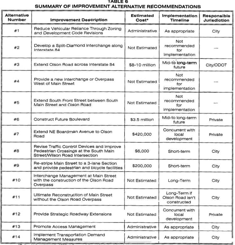
Summary of Improvement Alternative Recommendations 58 Street Design Standards...
67Roadway Improvements
...
72Interstate Highway Access Management Standards
...
73Minimum Spacing Standards Applicable to Freeway Interchanges with Two-Lane
...
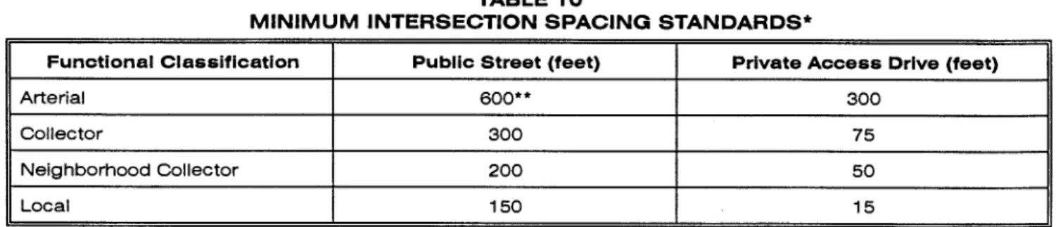
Crossroads 74 Minimum Intersection Spacing Standards...
75Private Access Driveway Width Standards
...
76Pedestrian And Bicycle System Improvements
...
81Update June 200 1 Preface City of Boardman Transpartation System Plan
Preface
This project is partially h d e d by a grant from the Transportation Growth Management (TGM) Program, a joint program of the Oregon Department of Transportation and the Oregon Department of Land Conservation and Development. TGM grants rely on federal Intermodal Surface Transportation Efficiency Act and Oregon Lottery funds. The contents of this document do not necessarily reflect the views or policies of the state of Oregon.
The progress of this plan was guided by the Management Team, Transportation Advisory Committee, Community Stakeholders, and the Consultant Team identified below.
Management Team
Tamra Mabbott Cheryl Jarvis-Smith
Morrow County Planning Department Oregon Department of Transportation
Kathy Moore
Manager, City of ~ o a r d m a n
George Ruby
Oregon Department of Transportation
Transportation Advisory Committee
Glaya Baker Hugh Homer
Robert Boss, M.D. John Prag
Grant Chapman Carolyn Skaubo
Sim Ten Eyck Debra Watson
Advisory Committee members devoted a substantial amount of voluntary time and effort to the development of the Transportation System Plan, and their participation was instrumental in the development of the recommendations that are presented in this report. In addition, Community Stakeholders provided critical guidance in developing the Transportation System Plan and are recognized on the following page. The Consultant Team and Management Team believe that the City of Boardman's future transportation system will be better because of their commitment.
Consultant Team
Kittelson & Associates, Inc.
Julia Kuhn, P.E. Wayne Kittelson, P.E. Marc Butorac, P.E. Chris Brehmer
Cogan Owens Cogan, Inc.
Linda Davis, AICP Kirstin Greene Matt Hastie
Murase Associates
Steve Shapiro
Kittelson & Associates, lnc.
Update June 200 7 Preface City of Boardrnan Transportation System Plan
Community Stakeholders List
Art Kegler, American West Properties
Bank of Eastern Oregon Boardman Auto Care
Boardrnan Chamber of Commerce
Karen Pettigrew, Boardman Park & Recreational District Raymond Michael, Boardman Pharmacy and Hardware Marc Rogelstad, Chief, Boardman Rural Fire Protection District
Boardman Texaco
Jack Bozarth, C&D Drive-In Devin Oil Company
Joseph Tatone, Dodge City Inn Inland Empire Bank
Gary Maughan Kathy McGowen
Morrow County School District Rich Cappotto, Nomad Restaurant Nugget Inn
Oregon Trail Library District Port of Morrow
Don Russell, Russell Oil Company
Kittelson & Associates, lnc.
Section 1
Update June 200 1 Introduction City of Boardman Transportation System Plan Section I
lntroduction
The City of Boardman, in conjunction with Morrow County and the Oregon Department of Transportation (ODOT), initiated a study of the city's transportation system during the summer of 1998. The purpose of this study was two-fold: to guide the management and development of appropriate transportation facilities; and to incorporate the vision of the community into a land use and transportation system that addresses both the potential for infill and redevelopment strategies and the multimodal needs of the community.
Several community-specific issues that needed to be addressed as part of the study process were identified at the project inception stage. The Boardman urban growth boundary (UGB) contains sufficient land for at least a 20-year period. Because such a large amount of land exists, there is a potential for continued low-density development and inefficient development patterns, which could make it difficult to provide utilities and services cost-effectively and efficiently. Low-density development could also consume more land than necessary and cause a need to expand the UGB earlier than might otherwise be necessary. Boardman also lacks an established downtown commercial core and has needs for additional, concentrated commercial development. How and where future commercial development occurs will be important in terms of helping Boardman establish a stronger identity and .character and will also affect the transportation system and needs. The analysis, findings, and recommendations of this report incorporate a diverse spectrum of vehicular, pedestrian, bicycle, and other multi-modal circulation and connectivity solutions.
This study was prepared as part of a Transportation Growth Management Grant and is formatted to provide the necessary elements for the City of Boardman to assemble its Comprehensive Plan. In addition, this document provides Morrow County and ODOT with recommendations for incorporation with their respective planning efforts.
State of Oregon guidelines stipulate that the TSP must be based on the current comprehensive plan land use map and must provide a transportation system that accommodates the expected 20-year growth in population and employment that will result from implementation of the land use plan. Oregon Revised Statute 197.7 12 and the Land Conservation and Development Commission (LCDC) administrative rule known as the Transportation Planning Rule (TPR) require that all jurisdictions develop the following:
a road plan for a network of arterial and collector streets; a public transit plan;
a bicycle and pedestrian plan; an air, rail, water, and pipeline plan; a transportation finance plan; and,
policies and ordinances for implementing the transportation system plan.
The TPR requires that alternative travel modes be given equal consideration and that reasonable effort be applied to the development and enhancement of the alternative modes in providing the future transportation system. In addition, the TPR requires that local jurisdictions adopt land use and subdivision ordinance amendments to protect transportation facilities and to provide bicycle and pedestrian facilities between residential, commercial, and employment~institutional areas. It is further stipulated that local communities coordinate their respective plans with county and state transportation plans.
Kittelson & Associates, Inc.
Update June 200 7 Introduction City of Boardman Transportation System Plan Section 7
STUDY AREA
The City of Boardman is located along the southern shore of the Columbia River in northern Morrow County, Oregon, as shown in Figure 1. The city currently benefits from several easily accessible modes of transportation. Boardman has convenient access to Interstate 84 via two grade-separated interchanges located near the downtown and the Port of Morrow, respectively. In addition, the city has convenient access to the Columbia River through the Port of Morrow. The city also enjoys rail service provided by Union Pacific Railroad.
Home to an estimated population of 2,795 persons (1998 census estimate), Boardman's development pattern was defined in a master planning effort that guided the city's relocation to high ground as dams were built on the Columbia River. According to the city's Comprehensive Plan, the master plan that was developed during the relocation of the city platted commercial and residential lots with mobile homes allowed only on certain selected lots in the original plat. The downtown area contains a mix of commercial, residential, and public land uses, with the major employers of the area located in the Port of Morrow.
Large residential lots north of the freeway and west of Main Street were developed to acquire land from the railroad and a 3 1-acre campus was reserved for the Riverside High School. The City of Boardman's
growth patterns that followed relocation were driven by the creation of thousands of acres of new farmland through center pivot irrigation, construction of the Portland General Electric coal-fired power plant at the Port of Morrow, and development of agri-business facilities at the Port. The transportation' network was constructed with these developments in mind.
Kittelson & Associates, lnc.
Update June 200 1 Introduction City of Boardman Transportation System Plan Section 1
PUBLIC INVOLVEMENT AND STUDY GOALS
The TSP planning process provided the citizens of Boardman with the opportunity to identify their priorities for future growth and development. Expressing their vision for the future in terms of goals and objectives for the TSP was a central element of the public involvement process. The goals and objectives identified by the community were used as guidelines for developing and evaluating alternatives, selecting a preferred transportation plan, and prioritizing improvements.
Three committees were formed to guide the planning process: the Management Team, the Transportation Advisory Committee (TAC), and the Community Stakeholders. The Management Team was composed of representatives of the City of Boardman, Morrow County, ODOT, and the consultant team. The Transportation Advisory Committee involved members of the City of Boardman Planning Commission. The Community Stakeholders included several members of the community with a specific interest in transportation and land use planning in Boardman.
The committees convened at several key junctures of the project including: project inception, completion of the existing conditions analysis, presentation of the future conditions and alternatives analysis findings, and presentation of the draft TSP. Through these meetings, the local transportation planning process evolved such that a general consensus was achieved and maintained among all parties in attendance. Given the city's Comprehensive Plan, and through the direction provided by the TSP committees and the public hearing process, a series of transportation system goals and objectives evolved that provided the planning process with direction as well as evaluation criteria. Those goals and objectives are listed below.
Goal 1
Promote a balanced, safe, and efficient transportation system.
Objectives
1. Develop a multi-modal transportation system that avoids reliance upon one form of transportation as well as minimizes energy consumption and air quality impacts.
2. Protect the qualities of neighborhoods and the community.
3. Provide for adequate street capacity and optimum efficiency.
4. Promote adequate transportation linkages between residential, commercial, public, and industrial land uses.
5. Examine the function of the freeway interchanges and establish land use and transportation policies that will maximize capacity and minimize conflict among uses.
6. Identify a preferred location for long term development of a central business district that can tie the north and south sides of the city together with a transportation system of streets, sidewalks, and bike paths.
7. Examine the location and mix of residential densities, including infill potential, to determine the most efficient pattern of residential development to maximize the use of existing and planned infrastructure and reduce vehicle miles for internal trips as well as make the most efficient use of the city's land supply.
Kittellson & Associates, Inc.
Update June 200 1 Introduction City of Boardman Transportation System Plan Section 7
Goal 2
Ensure the adequacy of the roadway network in terms of function, capacity, level of service, and safety.
Objectives
Develop a functional classification system that addresses all roadways within the study area. In conjunction with the functional classification system, identify corresponding street standards that recognize the unique attributes of the local area.
Identify existing and potential future capacity constraints and develop strategies to address those constraints, including potential intersection improvements, future roadway needs, and future street connections.
Evaluate the need for modifications to andlor the addition of traffic control devices.
Identify access spacing standards adjacent to state highway facilities that conform to the Oregon Highway Plan.
Provide an acceptable level of service at a11 intersections in the city, recognizing the rural character of the area. Intersection operations on state highways should conform to the level of service and volume/capacity ratio requirements identified in the Oregon Highway Plan.
Identify existing and potential future safety concerns as well as strategies to address those concerns.
Goal 3
Promote alternative modes of transportation.
Objectives
1. Develop a comprehensive system of pedestrian and bicycle routes that link major activity centers within the study area.
2. Encourage the continued use of public transportation services.
Goal 4
Identify and prioritize transportation improvement needs in the City of Boardman, and identify a set of reliable funding sources that can be applied to these improvements.
Objectives
1. Develop a prioritized list of transportation improvement needs in the study area. 2. Develop construction cost estimates for the identified projects.
3. Evaluate the adequacy of existing funding sources to serve projected improvement needs.
4. Evaluate new innovative funding sources for transportation improvements.
TRANSPORTATION SYSTEM PLAN STUDY METHODOLOGY AND ORGANIZATION
The development of the City of Boardman's Transportation System Plan began with an inventory of the existing transportation system and a review of the local, regional, and statewide plans and policies that guide land use and transportation planning in the city (Appendix "A" contains the plans and policies review). The system inventory included documentation of all transportation-related facilities within the
Kittelson & Associates, lnc.
Update June 200 1 Introduction City of Boardman Transportation System Plan Section 1
study area and allowed for an objective assessment of the current system's physical characteristics, operational performance, safety, deficiencies, and general function. A description of the inventory
process, as well as documentation of the existing conditions analyses and their implications, is presented in Section 2 of this report. The findings of the existing conditions analysis were presented to and verified by the TSP committees.
Upon completion of the existing conditions analysis, the focus of the project shifted to forecasting future travel demand and the corresponding long-term future transportation system needs. Development of long- term (year 2020) transportation system forecasts relied heavily on population and employment growth projections for the study area and review of historical growth in the area. Through the city's Comprehensive Plan and land use projections provided by the consultant team, reasonable assumptions could be drawn as to the potential for and location of future development activities. Section 3 of this
report, Future Conditions Analysis, details the development of anticipated long-term future transportation needs within the study area.
Section 4 of this report, Alternatives Analysis, documents the development and prioritization of
alternative measures to mitigate identified safety and capacity deficiencies, as well as projects that would enhance the multi-modal features of the local transportation system. The process by which future transportation system projects were identified and prioritized included extensive cooperation with the TSP committees. The impact of each of the identified alternatives was considered on the basis of individual merits, conformance with the existing transportation and land use system, as well as potential conflicts to implementation and integration with the surrounding transportation and land use system components. Ultimately, a preferred plan was developed that reflected a consensus as to which elements should be incorporated into the city's long-term transportation system.
Having identified a preferred set of alternatives, the next phase of the TSP planning process involved presenting and refining the individual elements of the transportation system plan through a series of decisions and recommendations. The recommendations identified in Section 5, Transportation System Plan, include a Roadway Network and Functional Classification Plan, a Pedestrian Plan, a Bikeway Plan, a Public Transportation Plan, and other multi-modal plans.
Section 6, Transportation Funding Plan, provides an analysis and summary of the alternative funding
sources available to finance the identified transportation system improvements.
The city's existing comprehensive plan and zoning ordinances were limited and did not allow the city to develop the type of transportation system desired. In an effort to rectify this situation and ensure compliance with the TPR, several comprehensive plan and zoning ordinance modifications have been developed. Development review guidelines were also drafted. The recommended modifications presented in Section 7, Policies and Land Use Ordinance ModiJications, address major land use and transportation issues identified through development of the TSP and reflect the desire to enhance all modes of the transportation system.
Finally, Section 8, Transportation Planning Rule Compliance, lists the requirements and
recommendations of the Oregon Transportation Planning Rule (OAR 660 Division 12) and identifies how the City of Boardman TSP satisfies that criterion.
Kittelson & Associates, lnc.
Section 2
Update June 200 7 misting Conditions
City of Boardman Transportation System Plan Section 2
Existing Conditions
INTRODUCTIONThe development of this transportation system plan began with an assessment of the existing land use and transportation system conditions. This section describes existing land uses and conditions for all transportation modes that the transportation system plan will address, including cars, trucks, bicycles, pedestrians, transit, air, and marine facilities. The purpose of this section is to provide an inventory description of existing facilities while setting the stage for a basis of comparison to future conditions.
LAND U S E
Boardman was incorporated in 1927. With construction of the John Day dam down river in the early l96O's, the town was relocated from its original site on the Columbia River to higher ground. The dam provided irrigation to open vast tracts of dry land to major agricultural enterprises. This in turn allowed the Port of Morrow to capitalize on the agricultural production and provide processing and shipping of agricultural products at the Port's facilities in Boardman. Railroad and marine facilities serve the Port of Morrow making it one of the largest in volume in the Columbia River basin. The Port also owns and operates an airport west of town, outside the UGB.
As will be documented later in the Future Conditions Analysis section of this report, the 1990's have been a period of phenomenal growth for Boardman. During the past decade Boardman has been one of the fastest growing communities in the state, growing from 1,387 people in 1990 to 2,795 by 1998, an increase of 102 percent or 13 percent per year on average. Growth has been and continues to be stimulated by a number of regional economic development forces including industrial development at the Port of Morrow. Growth is projected by year 2020 to be 4,523 persons in the city and 5,129 within the urban growth area.
The city has an abundance of developed and vacant industrial land north of the freeway that has coveted access to rail, surface and water transportation to move goods to national and international destinations. The majority of this land is owned by the Port of Morrow and leased to industries; most of the rest has been sold by the Port to industries that have located in the Port industrial district. This industrial land provides several hundred jobs to residents as well as others who commute to the city. Boardman is becoming an economic hub of regional significance. Transportation facilities have a major influence on Boardman's economic growth and its development pattern. Interstate 84 splits the community roughly one-third to the north and two-thirds to the south. The freeway has two interchanges. The interchange at the west-end of town provides access to commercial services and residential areas and the other, at the east-end, predominantly serves the Port of Morrow and industrial development. Figure 2 identifies zoning within the City of Boardman.
Commercial services are located both north and south of the freeway. The city has over 200 acres of vacant commercially-zoned land, more than will be needed within the next 20 years. Most of the vacant land is south of the freeway. The commercial district to the north, which includes City Hall, service stations, some restaurants, two motels and other miscellaneous commercial businesses, as well as the high school, is substantially built-out. Some redevelopment is occurring on the north side and the potential exists for more redevelopment in the future.
About 90 percent of the city's future residential development will occur south of the freeway based on the city's vacant land inventory. At least a 20-year supply of land exists for both single family and multi-
Kittelson & Associates, Inc.
City
of
BOARDMAN
Urban Growth Boundary City Limits Taxlots Zoning C1 FR2 R1 C2 ; IND R2 c3 MG R3 CFU PI SC EFU PUB SF40 SRI Scale = 1 :20000 Date : 6/28/99
Update June 200 1
City of Boardman Transportation System Plan
Existing Conditions section 2
single family housing. Affordable housing is generally plentiful but the city lacks higher income housing. One of the goals of the Strategic Plan is to promote a variety of housing and neighborhoods for all economic and age groups. Sidewalks are required in new subdivisions and there are several bikelpedestrian paths.
The 1997 buildable lands analysis found that new residential subdivision development is occurring at reasonable densities. However, the abundance of residential land and readily available city sewer and water facilities throughout the city have produced a disconnected residential development pattern south of the freeway where most new development is occurring. In addition, many newer residential developments are relatively distant from commercial services. These factors produce heavy reliance on autos for traveling within the community.
TRANSPORTATION FACILITIES
The City of Boardman's transportation system includes facilities that serve several different modes. All of these facilities are identified and discussed in detail in the remainder of this section.
Roadway Facilities
All public roadways within the City of Boardman are operated and maintained under the auspices of one of three jurisdictions -the Oregon Department of Transportation (ODOT), Morrow County, andlor the city. The following paragraphs highlight the existing roadway network, which is illustrated in Figure 3.
State Facilities
Interstate 84
The City of Boardman is conveniently located adjacent to Interstate 84, providing the local community with a high-speed facility to travel to adjacent communities such as Hermiston, Umatilla, and Pendleton. Interstate 84 is a major trucking route and has, in part, facilitated employment growth associated with industrial and shipping activities through the Port of Morrow and the city in general.
Interstate 84 is maintained by ODOT, which classifies the roadway as being of an Interstate Level of
Importance as described in ODOTYs 1991 Oregon Highway Plan (Reference 1). The primary function
of an Interstate Highway is to provide connections and links to major cities, regions of the state, and other states. Interstate 84 has a four-lane cross section and a 65 mile per hour posted speed limit.
Two grade-separated interchanges provide access to Boardman at opposite ends of the city. One interchange serves Main Street while the other provides access to the Port of Morrow via Laurel Lane. Interstate 84 disrupts the continuity of the city as it divides the city into two distinct geographic areas. In addition, the manner in which properties have developed require residents to cross the interstate, primarily on Main Street, on a daily basis. Most of the residential lands are located to the south of the interstate. The majority of the employment opportunities and services are located to the north of the interstate.
City of Boardman Facilities
The City of Boardman's roadway system is comprised of a number of streets that collectively feed the two Interstate 84 interchanges. The east-west orientation of the Columbia River, Interstate 84, the BPA Easement, and the Union Pacific Railroad right-of-way all limit the number and extent of north-south connections through the city and have shaped the local roadway network.
Kittefson & Associates, lnc.
.."..
.
, ,(NOT TO SCALE)
LEGEND
URBAN GROWTH BOUNDARY
w=w"""rsu*. CITY LIMITS
ING
ROADWAY
NETWORK
- . . - . . . .BOARDMAN, OREGON 2RTATION SYSTEM PLAN
Update June 200 1 Existing Conditions
City of Boardman Transportation System Plan Section 2
The City of Boardman Comprehensive Plan, through Chapter 12, identifies the need to develop an interim and ultimate street classification system. The intent of the interim plan is to provide adequate capacity and reasonable levels of service for low volume conditions through use of relatively narrow streets and simplified traffic control devices. The intent of the ultimate plan is to provide for a more robust roadway network capable of handling increased traffic volumes through a system of arterials and intersection improvements. The comprehensive plan does not, however, present a functional classification system for roadways within the city.
On-Street Parking
Limited striped on-street parking is provided along Front Street on both the north and south sides of Interstate 84.On-street parking is also provided on both sides of First Street near the post office. Within the residential areas, several homeowners appear to park on the shoulders of local roads, though parking spaces are not striped.
TRAVEL MODES/CONNECTIVIM OF MODES
An inventory of the existing street system was conducted within the urban growth boundary with the intent of identifying the locations of sidewalks, bike lanes, on-street parking, pavedlunpaved roadways, traffic control devices and signing, and posted speed limits. The findings of that inventory are summarized in the following paragraphs
Pedestrian System
The City of Boardman's existing pedestrian network system includes sidewalks along many of the local roads and a multi-use path along Main Street and Wilson Road. Figure 4 illustrates the roadways within the city that currently have multi-use paths or sidewalks on one or both sides of the street.
As is typical with many rural cities, the existing pedestrian system in the city is relatively complete in some core areas and virtually non-existent in others. The majority of the sidewalks are provided within residential areas. While the multi-use paths along Main Street and Wilson Road have significantly enhanced the city's pedestrian network, there is still a lack of sidewalks and pedestrian crossings along several key roadway facilities in the study area.
Bicycle System
The City of Boardman currently has two designated bicycle facilitieslmulti-use paths. As indicated in Figure 4, one of the paths provides connections from Marine Drive south to Front Street on the north side of Interstate 84. Currently, the path is not continuous, with the most notable break dictated by the narrow bridge carrying Main Street over the Union Pacific Railroad right-of-way. The second path travels from a point south of Interstate 84 to Wilson Road and then along Wilson Road between Faler Road and Anderson Road. It is the city's desire to ultimately provide bike routes to all areas of the town while avoiding vehicular conflicts where possible.
The City of Boardman has been recently notified that it has been awarded an Enhancement grant from the federally h d e d Transportation Efficiency Act for the 2 1" Century (TEA-2 1) program. These funds will enable the city to provide pedestrian and bicycle facilities on the Main Street bridge over the Union Pacific railroad right-of-way and continuous sidewalks and bicycle lanes along Main Street from the bridge to Interstate 84.
Kittelson & Associates, lnc.
3
-
STATE
LEGEND
I
URBAN GROWTH BOUNDARYI
X I P B ~ ~ R ( C I N LIMITS SIDEWALK
---
MULTI-USE PATHING PEDESTRIAN AND
'LE SYSTEM
BOARDMAN, OREGON )RTATION SYSTEM PLAN
Update June 200 7 Existing Conditions City of Boardrnan Transportation System Plan Section 2
PUBLIC TRANSPORTATION SYSTEM
Limited public transportation serves within the City of Boardman are available through the county, the local school district, the RSVPICAPECO program, and Greyhound.
Morrow County Special Transportation Program
Morrow County provides two public transportation programs that serve the City of Boardman. A senior bus service is available to groups by appointment and provides service for seniors, disabled persons, and low-income persons. Other users are welcome as long as they do not displace the primary users (i.e., seniors, the disabled, and the disadvantaged). A dial-a-ride service is also available by appointment to serve the same audience. Both programs are funded through a tobacco tax and rely on a volunteer pool of drivers. While increased usage of these services is desirable, there are no current or pending plans to expand public transportation services to the area.
Relevant Information
*
Program Contact: John Wenholz, County Commissioner, Phone (541) 922-3941Program Coordinator: Barbara Hayes, Phone (54 1) 676-5667
Ride Scheduling Contact: Boardman Senior Center, Phone (541) 481-3257
Scheduling Hours: Monday-Friday 9:00 a.m. to 5:00 p.m.
Service Area: The Morrow County Special Transportation Program serves all of
Morrow County and has provided trips out of county for medical services including trips to the Tri-Cities area of Washington State. Because there are no vans in Boardman, no individual trips are provided as they are in other parts of the county.
EquipmentIFacilities in Boardman (As of March 3 1, 1999):
1. 1987 Ford 14 Passenger Van - 60,075 miles (Handicapped accessible)
2. 1991 Ford 14 Passenger Van - 62,8 12 miles (Handicapped accessible)
Other Services
Boardman has intercity bus service provided by Greyhound Lines, Inc. Currently, Lines 5547, 5535, and 5549 depart from Boardman daily for Portland at 6:25 a.m., 1150 a.m., and 3:35 p.m., respectively. Route 5530 departs Portland at 1250 p.m. daily and makes a scheduled stop in Boardman at 4:10 p.m. with continuing service to Boise, Idaho and Salt Lake City, Utah.
The local school district provides school bus service within portions of the city and to the neighboring community of Irrigon (Irrigon students are bused to Riverside High School in Boardman and Boardman students are bused to the Columbia Middle School in Irrigon) on school days.
Finally, the RSVPICAPECO program based in Pendleton provides one additional transportation option. Under the RSVPICAPECO program, qualified drivers are reimbursed for transporting others in personal vehicles when the local county transportation service is unavailable. This program requires an initial application process and authorization prior to persons being qualified for reimbursement. Reimbursement is then available for qualified trips on a per mile basis. The RSVP Program Contact is Don Thorndike, phone (541) 278-5669.
Kittelson & Associates, lnc.
Update June 200 1 Existing Conditions
City of Boardman Transportation System Plan Section 2
General Comments
Discussions with local agency staff and TAC members indicated that, with the exception of school bus and Greyhound service, the public transportation services available are not as well used as they could be. A commonly repeated theme was the notion that there is a need to create greater awareness of the programs among community members. Community input stressed the need for convenient access to public transit service for the elderly. It was further observed that the population under the driving age is particularly under-served and, as the community grows in geographic size, their overall accessibility will be diminished. Although enhanced service is desired, no segment of the city's population was specifically identified as being without transportation service.
Aside from the aforementioned services, for most of the city's residents, private transportation is the only available option to get to the local medical, social, and retail services and the educational and employment opportunities located in adjacent communities.
AIR TRANSPORTATION SYSTEM
The City of Boardman has access to several airport facilities. The nearest airfield is the Boardman Airport located five miles west of Boardman, but it serves only small aircraft and U.S. Navy operations at this time. The airport, which is owned by the Port of Morrow, was originally designed to service heavy bombers and large commercial aircraft, suggesting that future expansion of the airport's operations to include larger aircraft is feasible. The airport's runway is 4,200 feet long and serves as a focal point for a growing airport industrial park. The airport has medium intensity runway lighting and in 1998 there were three aircraft based at the airport and an estimated 1,500 aircraft operations annually.
Regional freight cargo and air passenger services are provided at the Eastern Oregon Regional Airport at Pendleton, located approximately 45 miles southeast of Boardman via Interstate 84, and at the Tri- Cities Airport located approximately 55 miles to the north in Pasco, Washington. Both the Eastern Oregon Regional Airport and the Tri-Cities airport provide regional passenger air service, connecting to national and international air service at the Portland International Airport. In addition, the City of Hermiston owns and operates a general aviation airport that offers charter service.
RAILROAD TRANSPORTATION SYSTEM
Freight rail service is available via the Union Pacific Railroad. The Union Pacific mainline, which roughly parallels Interstate 84, serves 30 to 40 trains daily pending local and regional shipping needs and market fluctuations. According to ODOT's Rail Section, the rail line carries approximately 35 million tons of freight annually
-
the equivalent of nearly 1 million tractor trailer loads of freight.Union Pacific's track is classified as being in Federal Railroad Administration Class IV condition, permitting freight trains speeds of 60 miles per hour and passenger trains speeds up to 79 miles per hour. ODOT's Rail Section identified four rail shippers in Boardman: Boardman Farms, Lamb-Weston, Oregon Potato, and the Port of Morrow.
The rail line through Morrow County was serviced by passenger trains in the past. When the passenger train was operating between Portland, Boise and points east, approximately 12,000 passengers annually boarded at Oregon stations outside Portland. By comparison, the Portland-Eugene Willarnette Valley Rail Corridor serves over 140,000 passengers a year. Arntrak passenger service has been discontinued and the last passenger train operated over the line on May 10, 1997. When passenger service was operated, Morrow County was served from the station at the Hinkle railyards, which is located one mile south of Hermiston. There was no passenger stop in Morrow County.
Kitteson & Associates, lnc.
Update June 200 1 Existing Conditions
City of Boardman Transportation System Plan Section 2
ODOT's Rail Section had no record of any grade crossing problems on the segment of track in the City of Boardman. All of the major roadways crossings were grade separated with the remainder being very low volume local roads. It was further noted that the Port of Morrow has narrow bridge over the tracks in Boardman that provides port access. Ultimately, the Port would like this structure replaced.
There are no railroad branch lines in the City of Boardman. Further, according to ODOT, no trackage in Morrow County needs rehabilitation.
MARINE TRANSPORTATION SYSTEM
Marine transportation is available to the City of Boardman though the Port of Morrow. Within the Port, Tidewater Terminal maintains a large container terminal and additional docking facilities are available that support transfer of wood chips, aggregates, and grain. Overall, the Port of Morrow maintains six docks, two berths for barges, and two overhead cranes for loading purposes. Four large companies serving the Port of Morrow handle approximately 2,000 containers at the docks each month (Reference 2).
PIPELINE TRANSPORTATION SYSTEM
There is an U.S. Transmission natural gas pipeline serving the co-generation plant located in the Port of
Morrow. The residential areas of the community have natural gas service provided by Cascade
Natural Gas. No other major pipelines within the City of Boardman were identified at the time the TSP was prepared.
TRAFFIC OPERATIONS ANALYSIS
Ten intersections within the city were selected for operational analysis under 1998 existing conditions. Those intersections include:
Marine DriveIMain Street Front StreetIMain Street
Columbia Avenuemain Street Interstate 84 Westbound Rampmain Street
Olson RoadIColumbia Avenue Interstate 84 Eastbound RampMain Street
Laurel LaneIColumbia Avenue Front StreetISouth Main Street
Boardman Avenue/Main Street Wilson RoadISouth Main Street
Traffic Control
All of the study intersections within the City of Boardman are currently unsignalized. Figure 5 illustrates the existing lane configurations and traffic control devices at each of the study intersections. Traffic operations at each of the intersections were examined during the weekday p.m. peak hour. The p.m. peak period represents the worst case condition for traffic operations on the transportation system. Travel patterns during this weekday time period typically combine commuting, shopping, and recreational trips, thus generating higher traffic volumes on the transportation system than during any other time period or day of the week.
Traffic Volumes
Weekday p.m. peak hour manual traffic volume counts at the intersections were conducted in November
1998. Manual turning movement traffic counts were conducted between 4:00 p.m. and 5:30 p.m. on a
mid-week day. The highest one-hour flows during these periods were used in this study.
Kittekon & Associates, lnc.
1
EXISTING LANE CONFIGURATIONS AND
-
APPROACH LANE, INDICATINGUpdate June 200 7 Existing Conditions
City of Boardman Transportation System Plan Section 2
Based on the turning movement counts conducted at study area intersections, the system-wide p.m. peak hour of traffic on a typical weekday afternoon was estimated to occur between 4:00 and 5:00 p.m.
Existing weekday p.m. peak hour traffic volumes are shown in Figure 6 . Traffic volumes have been
rounded to the nearest five vehicles per hour.
It should be noted that the community also identified congestion concerns occurring on weekdays between 3:00 and 3:45 p.m. Specifically, the intersections of Boardman Avenuemain Street and Columbia Avenuemain Street were identified as areas of concern during this time period. The congestion is related to the near-simultaneous release of students from the Riverside High School and the change of shifts at a major local employer. Subsequent field study of this condition determined that the weekday p.m. peak hour represented worst-case conditions and, accordingly, no further analysis of the 3:00 p.m. time period was completed.
Level of Service Analysis
Using the weekday p.m. peak hour turning movement volumes shown in Figure 6, an operational analysis was conducted at each of the study area intersections to determine existing levels of service. All level of service analyses described in this study were conducted in accordance with the 1994 Highway Capacity Manual, published by the Transportation Research Board (Reference 3). Appendix "B" summarizes the level of service concept.
To ensure that this analysis was based on a reasonable worst case scenario, the peak 15 minute flow rate during the weekday p.m. peak hour was used in the evaluation of all intersection level of service analyses. For this reason, the analyses reflect conditions that are only likely to occur for 15 minutes out of each average weekday p.m. peak hour. Traffic conditions during all other weekday periods will likely operate under better conditions than those described in this report. (It should be noted that peak seasonal traffic conditions typically occurs during the summer harvest season, hence Design Hour Volumes may be up to 25 percent higher than the peak hour analyzed in the TSP.)
Kittelson & Associates, lnc.
1998
EXISTING TRAFFIC VOLUMES
WEEKDAY PM PEAK HOUR
C I N OF BOARDMAN, OREGON TRANSPORTATION SYSTEM PLAN
JUNE 1999
Update June 200 1 Existing Conditions
City of Boardman Transportation System Plan Section 2
Unsignalized Intersections
For unsignalized two-way stop-controlled (TWSC) intersections, level of service (LOS) is based on an intersection's capacity to accommodate the worst, or critical, movement. Typically, the left-turn from the stop-controlled approach is the most difficult movement for drivers to complete at a TWSC intersection. This is due to this movement being exposed to the greatest potential number of conflicting, higher-priority movements at the intersection. Available gaps in the through traffic flow of the uncontrolled approach(es) are used by all other conflicting movements before the side-street left-turn can be negotiated. Therefore, the number of available gaps for the side street left-turn to negotiate its movement safely is likely .to be substantially lower than any other movement. As a result, the side-street left-turn typically experiences the highest delays and the worst level of service. For the Interstate 84 corridor through the City of Boardman, ODOT stipulates that major street level of service "A" through "C" are considered acceptable. Table 1 summarizes the level of service results for the unsignalized study intersections.
As Table 1 indicates, all of the unsignalized study area intersections operate at acceptable levels of service under existing weekday p.m. peak hour conditions.
TABLE 1
1998 MISTING PM PEAK HOUR LEVEL OF SERVICE,
UNSIGNALIZED INTERSECTIONS
TRAFFIC SAFETY
Another important aspect of the transportation system is safety. The safety analysis described in the following section focuses on the accident history for the study intersections within the City of Boardman urban growth boundary.
lntersection Accident Analysis
The accident history of the study intersections was examined for potential and existing safety problems. ODOT accident data for the period January 1993 through June 1998 were used for this analysis. In addition, the ODOT District 12's 1996- 1998 Safety Priority Index System (SPIS) lists were reviewed. The SPIS lists identify locations with relatively high accident rates and locations that have been the site of one or more fatal accidents.
Intersection Marine DriveIMain Street Columbia Avenuemain Street Boardman Avenuemain Street Front StreettNorth Main Street
1-84 Westbound Rampmain Street
1-84 Eastbound RampIMain Street
Front StreetlSouth Main Street Wilson RoadISouth Main Street Olson RoadIColumbia Avenue
Laurel LaneIColumbia Avenue
Klttelson & Associates, lnc.
Update June 2001 by TriLand Design Group, lnc.
Legend: LOS = Level of Service, V/C = VolumeICapacity Ratio
Critical Movement LOS A A B B B B B A A A Critical Movement Westbound Westbound Westbound Westbound Westbound Eastbound Eastbound Southbound Southbound Westbound Left Major Street LOS A A A A A A A A A A V/C 0.02 0.1 3 0.06 0.06 0.23 0.05 0.07 0.24 0.01 0.03 Average ~ e l a y (sechre h) 3.7 5.0 6.0 7.2 8.4 8.7 7.5 4.8 3.6 4.3
Update June 200 1 Existing Conditions City of Boardman Transportation System Plan Section 2
Review of the three respective annual SPIS lists indicates that no SPIS sites are located within the City of Boardman. Table 2 presents accident rates for the individual study intersections. Accident rates for intersections are calculated by relating the total entering volume of traffic at the intersection, on an average daily basis, to the number of reported accidents for a given period of time. The accident rate for intersections is expressed as the number of accidents per million entering vehicles (acclmev).
TABLE 2
STUDY INTERSECTION ACCIDENT RATES
1-84 Eastbound Ramp/Main Street
1
0.091
111
Front StreetJSouth Main Street
1
0.201
211
Wilson Road/South Main Street
I
1.06I
911
As shown in Table 2, the Wilson RoadSouth Main Street intersection was the only study intersection that had more than two reported accidents over the 5.5-year analysis period. The Wilson RoadSouth Main Street, which had an accident rate of 1.06 accidentslmev, was the site of nine reported accidents over the 5.5-year analysis period, including one fatal accident. The majority of the accidents were attributed to traffic on South Main Street not yielding the right-of-way to vehicles on Wilson Road (the Main Street approaches are stop-controlled; drivers on Wilson Road do not have to stop at the intersection). Four of the nine accidents occurred during inclement weather, two during icy conditions and two during wet weather. All but one of the accidents occurred during daylight conditions and one of the accidents resulted in a westbound vehicle that had been travelling on Wilson Road being overturned. The single fatal accident (which did not involve the overturned vehicle) was attributed to drunken driving and excessive speed.
Olson Road/Columbia Avenue Laurel Lane/Columbia Avenue
The remainder of the accident data did not reveal any specific safety problems or discernable patterns amongst the accident type, suggesting that the intersections are not exhibiting geometric or safety deficiencies that are leading to accidents. The accidents at the Front StreetNorth Main Street intersection,
Interstate 84 Eastbound RampNain Street, and the Olson RoadIColumbia Avenue intersection were
attributed to adverse environmental conditions such as ice or snow. Of the two accidents at the Interstate
84 Westbound RampMain Street intersection, one was attributed to adverse weather and the second was
a rear-end accident resulting from a driver following another car too closely. The single accident at the North Main StreetColumbia Avenue intersection was attributed to a young driver who failed to yield the right-of-way.
OTHER IDENTIFIED MISTING TRANSPORTATION DEFICIENCIES
As an extension of the existing conditions analysis, different aspects of the transportation system with existing deficiencies were identified. A description of the deficiencies and potential improvements
'ODOT Accident data search period of 1993 - 1998
0.54 0.0
Kittelson & Associates, Inc.
Update June 2001 by TriLand Design Group, lnc.
1
Update June 200 1
Ciiy of Boardman Transportation System Plan
Existing Conditions Section 2
follows. The summary is based on field data/observations and inforrnatiodsuggestions that were made by members of the respective transportation agencies and the general public.
Wilson Roadmain Street Intersection
The accident data analysis indicated that there is an existing safety deficiency at the Wilson RoadMain Street intersection. Community comments also indicated concerns with the safety of the Wilson RoadfMain Street intersection. The location of the intersection between residential housing and the elementary school was noted to generate pedestrian demand (along the multi-use path) across Main Street. Community comments indicated a desire to ensure the safety of school children and other persons walking through the intersection. In addition, it was noted that a fire station is located west of the intersection on Wilson Road. Hence, it was the community's desire that any form of mitigation at the Wilson Road/Main Street intersection consider both the safety of pedestrians and the ability to allow for unimpeded emergency response from the fire station.
Field inspection of the Wilson RoadIMain Street intersection revealed a vertical curve on Wilson Road east of the intersection that limits sight distance. Further, the curb radius of the intersection allows for high speed turns from Wilson Road westbound onto Main Street that affects the safety of pedestrians crossing the intersection.
North Main Street
Members of the Boardman community raised several concerns regarding the cross-section and function of Main Street, particularly north of Interstate 84. These issues reflect both vehicular and pedestrianlbicycle access concerns and are summarized below.
The current lack of separate pedestrian or bicycle facilities along Main Street north of Interstate 84 raises safety concerns amongst community members. Several agency staff members and citizens noted that, although there is a striped multi-use path along the western edge of North Main Street, no physical barrier separates the path from travel lanes. Instead, vehicles routinely cross the striped path to access businesses along North Main Street. Similarly, there are no sidewalks on Main Street south of Interstate 84 until the multi-use path begins (refer to Figure 4), thus forcing pedestrians onto roadway shoulders and parking lots along the commercial business frontage located south of the interstate.
The lack of access management along North Main Street in conjunction with growing traffic volumes on the roadway impact community mobility, making access to Main Street from side streets increasingly difficult.
There is a perception among local residents that drivers' speeds along the Main Street are too fast. The parking of large trucks along the shoulders of Main Street (and to a lesser extent, cars) near the Interstate 84 interchange was noted to obstruct visibility for drivers at adjacent intersections.
North Main Street Bridge
The existing North Main Street bridge over the Union Pacific Railroad right-of-way is a narrow two-lane structure. There are no sidewalk or bicycle facilities on the existing structure, though pedestrians and bicyclists routinely use the bridge to access recreational activities along the Columbia River shore. The city has recently received federal funding to add sidewalks and bicycle lanes to the existing bridge structure.
Kittelson & Associates, lnc.
Update June 200 7 Existing Conditions
City of Boardman Transportation System Plan Section 2
System Connectivity
During the TAC meeting process, it was noted that Interstate 84 and the Union Pacific Railroad both serve
as barriers to north-south travel. Accordingly, there is a continuing need to provide strategic north-south multi-modal connections across both the interstate and the railroad line. Similarly, there is a need to ensure that the city provides adequate east-west facilities parallel to Interstate 84 such that the community does not become entirely dependent on interstate access to facilitate local trips. In addition, with the large amount of residential development occurring on the south side of the city, there is a need to review the layout of the city's roads to ensure that reasonable connectivity is preserved.
SUMMARY
Through an inventory of existing conditions, several key findings were identified. Those findings are summarized below.
The City of Boardman was redefined through a master planning effort undertaken prior to relocation of the city in conjunction with dam construction along the Columbia River.
The city is located at the crossroads of the Columbia River, Interstate 84, and the Union Pacific Railroad, thereby offering many modal opportunities.
The city is limited in north-south growth and connectivity due to local topographical constraints such as Interstate 84, the Union Pacific Railroad right-of-way, and the Columbia River. While these facilities will continue to present constraints to both growth and transportation connectivity, they are essential components of the city's livelihood.
Sidewalk facilities are concentrated in residential areas throughout the city. Two multi-use paths, one along Main Street, and one along Wilson Road, serve as backbones linking the north and south sides of the city. Many other local roads tend to exhibit disjointed or nonexistent sidewalks. Public transit service is available in the form of a senior bus and dial-a-ride service provided through Morrow County. Greyhound bus service is also available.
The city has convenient access to both rail and marine shipping alternatives available though the Port of Morrow. Within the Port, a large container terminal and other docking facilities are available that support transfer of wood chips, aggregates, and grain.
On a typical weekday afternoon, the transportation system experiences its peak roadway traffic demand between 4:00 and 5:00 p.m. During this peak period, the transportation system operates well within established standards.
The Wilson RoadISouth Main Street intersection had nine reported accidents during the period of January 1993 through June 1998. The history of accidents at this intersection suggests that
mitigation measures should be considered. Potential mitigation measures should address both pedestrian accessibility and ease of access for emergency vehicles responding from the fire station located on Wilson Road.
Review of historical ODOT accident data did not reveal safety deficiencies at any of the remaining study intersections.
The city has recently obtained funding to add sidewalks and bicycle lanes to the existing Main Street bridge over the Union Pacific Railroad right-of-way.
Kittelson & Associates, lnc.
Section
3
Update June 200 1
Ci& of Boardman Transporfation System Plan
Future Conditions Analysis Section 3
Future Conditions Analysis
INTRODUCTIONThis section presents estimates of long-term future travel conditions within the TSP study area. The long- term future transportation needs for the City of Boardman were examined based on available employment and population forecasts, identified development activities, results from the operational analysis of the existing street system, and extensive discussions with regional transportation personnel and representatives from the City of Boardman.
TRANSPORTATION DEMAND
Future transportation demand within the City of Boardman was estimated based on expected growth in the study area population, employment, and traffic traveling through the study area for the horizon year 2020. Future growth estimates were developed based on historical traffic volume trends in the study area as well as consideration of the unique trip making characteristics of residential and employment-based activities. The estimation included a review of the land use mix proposed in the city's Comprehensive Plan.
Land UseIDemographics
Year 2020 traffic volumes on the City of Boardman's transportation system were forecast based on population and employment estimates developed by the State of Oregon for Morrow County and the city. These estimates were compared against recent development trends, planned developments, and forecast growth rates provided by local agencies to verifL their appropriateness. The 20-year planning horizon was chosen to ensure compliance with the Transportation Planning Rule.
Population and Employment Projections
Tables 3 and 4 summarize population and employment projections prepared for the City of Boardman in conjunction with the TSP process. In reviewing the two tables, it should be noted that the estimates contained in Table 3 include the population within the city limits as well as the Urban Growth Area
(UGA). The employment estimates shown in Table 4 are for the city only.
TABLE 3
POPULATION PROJECTIONS
II
Morrow County ProjectionsII
Year
City of Boardman Projections 1997
1990
Klttelson & Associates, lnc.
Update June 2001 by THLand Design Group, lnc. ProjectedPopulation
-Including UGA
Annual Percent Change
Projected Population Annual Percent Change
2,700 3,062 10.0% 1,387 -- -- 2000 -- -- 2015 3,126 3,545 5.0% 2002 9,895
--
2020 2005 1997-2020 Average 3,446 3,908 5.0% 11,131 4.0% 2010 3,936 4,463 1.6% 3,635 4,123 1.8% 12,039 4.0% 4,240 4,808 1.5% 12,701 1.8% 4,523 5,129 1.3% -- 2.3% 13,750 1.6% 14,812 1.5% 15,801 1.3%--
2.1 %Update June 200 1
City of Boardman Transportation System Plan
Future Conditions Analysis Section 3
TABLE 4
EMPLOYMENT PROJECTIONS
Year
1
19901
19971
20001
20021
20051
20101
20151
202011
II
Morrow County ProjectionsII
City of Boardman Projections
As shown in Table 3, the City of Boardman's population (including those persons in the UGA) is forecast to grow by an average annual rate of 2.3 percent (approximately 2,065 people) between 1997 (estimated population of 3,062) and 2020 (projected population of 5,129). During the same 23-year period, approximately 780 additional employment opportunities are anticipated in the city. The growth projections prepared for the city suggest that the city's growth will be substantial in the near-term and will moderate in the long-term.
Projected Employment Annual Percent Change
Over the course of the same forecasting period, the population of Morrow County is projected to increase by approximately 2.1 percent annually (from an estimated population of 9,895 in 1997 to a projected population of 15,801 in 2020). Countywide employment is expected to increase by approximately 1,365 jobs during the same 23-year period. The County is anticipating strong growth in the near-term horizon with the annual growth rate more closely paralleling Boardman's after the year 2005. Clearly, with over half of all the anticipated countywide job additions occurring in the City of Boardman, the city will be contributing significantly to the region's future.
1,261
7.0%
Such findings are reflective of the current development patterns being experienced in the area, including large-scale development activities that have been transpiring within Boardman in the last few years. The availability of new employment opportunities related to the Two Rivers Correctional Facility, the U.S. Army Chemical Weapons Incinerator Project, the Wal-Mart Distribution Center and other projects in neighboring communities, in conjunction with job growth in Boardman, is expected to result in continued residential development in Boardman.
641
--
3,613 1.9% 3,449 2.5% Projected Employment Annual Percent ChangeIt should be noted that the employment rate in Boardman was estimated to be lower than the population growth rate for the period 1990 through 1997 because of the previously mentioned employment opportunities in neighboring communities. Further details regarding the employment and growth assumptions are detailed in Appendix "C."
1,444 7.0% 1,029
7.0%
Anticipated Future Growth
In an effort to account for regional traffic growth, a net annual growth rate was chosen to forecast the year 2020 traffic analysis. This rate was determined based on a review of historical traffic volume trends, anticipated population and employment growth, regional population densities, and local knowledge of planned development.
3,890 1.5% 2,232
--
Kittelson & Associates, lnc.
Update June 2001 by TriLand Design Group, lnc.
1,528 1.9% 4,097 1 .O% 2,924 3.93% 1,646 1.5% 4,290 0.9% 3,283 3.93% 1,730 1 .O% 1,809 0.9%