James Madison University
JMU Scholarly Commons
Senior Honors Projects, 2010-current Honors College
Spring 2018
An archaeological perspective on architectural
evolution at Fort Harrison
Rachel Nicole Bergstresser
James Madison University
Follow this and additional works at:https://commons.lib.jmu.edu/honors201019
Part of theArchaeological Anthropology Commons, and theOther Architecture Commons
Recommended Citation
Bergstresser, Rachel Nicole, "An archaeological perspective on architectural evolution at Fort Harrison" (2018).Senior Honors Projects,
2010-current. 604.
An Archaeological Perspective on Architectural Evolution at Fort Harrison _______________________
An Honors College Project Presented to the Faculty of the Undergraduate
College of Arts and Letters James Madison University _______________________
by Rachel Nicole Bergstresser
Accepted by the faculty of the Department of Sociology and Anthropology, James Madison University, in partial fulfillment of the requirements for the Honors College.
FACULTY COMMITTEE:
Project Advisor: Dennis Blanton, Ph.D. Assistant Professor, Anthropology
Reader: Julie Solometo, Ph.D. Associate Professor, Anthropology
Reader: Gabrielle Lanier, Ph.D. Professor, History
Reader: Debbie Sturm, Ph.D. Associate Professor, Psychology
HONORS COLLEGE APPROVAL:
Bradley R. Newcomer, Ph.D., Dean, Honors College
PUBLIC PRESENTATION
Table of Contents
List of Figures ...iii
List of Tables ...v
Acknowledgements ...vi
Introduction ...1
Statement of Objectives ...3
Background ...3
Fort Harrison Architectural History ...7
Shenandoah Valley Settlement ...13
Shenandoah Valley Architecture ...17
Shenandoah Valley Farm Layouts ...23
Previous Archaeology ...25
Excavation Procedures ...28
Stratigraphy & Integrity ...29
Archaeological Results- Shovel Test Pits ...36
Archeological Results- Unit Excavation ...57
Interpretation ...79
Significance...90
Recommendations ...91
References Cited ...92
List of Figures
1 Present Day Fort Harrison
2 Aerial Photograph of Present Day Fort Harrison Site 3 1749 Original Stone Structure- First and Second Floor Plan 4 1850s Addition and 1860s Renovations- First Floor Plan 5 1850s Addition and 1860s Renovations- Second Floor Plan 6 Full Site Plan
7 Zoomed Site Plan of Yard and Southern Pasture 8 Unit 1 East Profile
9 Unit 2 East Profile 10 Unit 3 East Profile 11 Unit 4 South Profile 12 Unit 5 South Profile 13 Unit 6 South Profile 14 Unit 7 South Profile
15 Northern Cultivated Field Artifact Type Percentages 16 Yard and Southern Pasture Artifact Type Percentages 17 Redware Fragment
18 Feather Edge Creamware Fragment 19 Shell Edge Whiteware Fragment 20 Pearlware Fragment
21 Cut Nails
22 Window Glass Fragment 23 Bottle Glass Fragment 24 Bone Fragment
25 Tooth Fragment 26 Pipe Stem Fragment
30 Shovel Test Pit Pearlware Distribution 31 Shovel Test Pit Whiteware Distribution
32 Shovel Test Pit Hand Wrought and Cut Nail Distribution 33 Refined Earthenware Type Percentages
34 Nail Type Percentages
35 Unit and Level Artifact Total Counts 36 Unit 2 Base Stratum II Plan View 37 Unit 4 Base Stratum I Plan View 38 Unit 4 Base Stratum II Plan View 39 Unit 5 Base Stratum II Plan View 40 Unit 7 Base Stratum I Plan View 41 Unit 7 Base Stratum II Plan View 42 Photograph Unit 7 Base Stratum II 43 Oakfield Core Profile Unit 7 44 Feature Boundaries Plan View
45 1875 Map of Rockingham County- Harrison Property and Rice Property 46 1875 Map of Rockingham County- Harrison House and Adjacent Roads
List of Tables
1 History of Building Ownership
2 Shovel Test Pit Artifact Types- Northern Cultivated Field
3 Shovel Test Pit Refined Earthenware and Nail Types- Northern Cultivated Field 4 Shovel Test Pit Artifact Types- Yard and Southern Pasture
5 Shovel Test Pit Refined Earthenware and Nail Types- Yard and Southern Pasture 6 Shovel Test Pit Artifact Types- Koogler Yard
7 Unit and Level Artifact Types
8 Unit and Level Refined Earthenware and Nail Types 9 Summary of Features
10 Shovel Test Pit Artifact Catalogue 11 Unit Artifact Catalogue
12 Miscellaneous Artifact Catalogue 13 Pipe Fragment Catalogue
14 Animal Bone Fragment Catalogue 15 Modern Day Material Catalogue
Acknowledgements
I would like to express my appreciation to my academic advisor, Dr. Dennis Blanton, for his guidance, enthusiasm, and constructive critiques of this research work. I would also like to thank Dr. Julie Solometo for her advice and helpful suggestions on this project. My thanks are also extended to Dr. Gabrielle Lanier for her expertise in architectural history and to Dr. Debbie Sturm for her valuable support and comments as someone outside of the discipline of archaeology and history.
I would also like to extend my gratitude to Fort Harrison, Inc., Pat Early, and the Koogler family for their willingness to have archaeological investigation performed at Fort Harrison and their general enthusiasm regarding the findings.
Finally, I wish to recognize all those students who helped with archaeological fieldwork and laboratory work, providing me with valuable data.
Introduction
Fort Harrison is a historic home located in Rockingham County just north of Dayton, Virginia. Occupation of the site began in 1749, when the original limestone house was
constructed by Daniel Harrison. The Harrison family was one of the first that settled within the Shenandoah Valley. When the city of Harrisonburg was founded it was named after Thomas Harrison, who was the brother of Daniel Harrison. Throughout occupation of the site changes took place to the original limestone structure that was constructed in 1749. First, a brick addition was constructed to the north of the original structure and later renovations to the original
limestone structure took place. Archaeological investigation of the site has taken place on
multiple occasions, most recently in the spring of 2016 through the fall of 2017. Results from the fieldwork and subsequent analysis suggest that the orientation of the extant dwelling was
Statement of Objectives
This project seeks to evaluate the hypothesis that the main (front) entrance to the house was relocated from the northerly-facing side to the southerly-facing side, in conjunction with the decision to enlarge the structure with an addition to the north side. If the hypothesis is supported, the ultimate goal is to answer why the house was reoriented.
The continuation of archaeological investigation at Fort Harrison contributes to the understanding of its occupation and changes to the dwelling, and it also contributes to the study of early settlement and cultural change within the Shenandoah Valley of Virginia.
This paper will first provide historical background information about Daniel Harrison, the history of occupation at Fort Harrison, and the architectural changes that took place over time. Second, this paper will provide context from the three beginning phases of settlement in the Shenandoah Valley of Virginia beginning in the 1730s to the early 1800s. Third, patterns and changes of architectural styles and farm layouts within the Shenandoah Valley will be outlined and compared to that found at Fort Harrison. Next, the archaeological process and archaeological results are described. Finally, the paper develops an interpretation of the archaeological findings, which includes an analysis of the spatial patterns found, the implications that they pose regarding the proposed change in structure orientation, and reasons as to why a change in orientation may have occurred.
Background
The following history of occupation is drawn from two sources of information. The first is the website for Fort Harrison, which is overseen by Fort Harrison, Inc. (Fort Harrison, Inc.
written with information provided by an architect who examined the structure at that time (Fetzer and Sease 1979).
Fort Harrison was initially built by Daniel Harrison, the eldest son of Isaiah Harrison and his second wife Abigail, who were from Long Island, New York. Isaiah and Abigail along with their children, including Daniel, moved from Smithtown, Long Island to Sussex County,
Delaware in 1721. The family lived on Maiden Plantation, which encompassed 900 acres of land until the death of Abigail in 1732 when the plantation was divided among the ten children of Isaiah Harrison.
Daniel and his family moved from Delaware to the Shenandoah Valley of Virginia around 1738. Eight of Isaiah Harrison’s children settled in areas within the Shenandoah Valley around Harrisonburg, Virginia. Originally, Daniel purchased a land tract on Naked Creek, which is now located in Augusta County. Daniel then purchased 400 acres on the Dry Fork of Smiths Creek. In 1749 Daniel purchased a 120-acre piece of land from Samuel Wilkins near the western branch of Cooks Creek, now in Dayton, where he built the limestone house still standing today.
Daniel Harrison constructed a water-powered mill and distillery on his property, and obtained a license to operate an inn within his home. He was a prominent leader in the
community, especially during the French and Indian War as a captain in the militia. Legend has it that the stone house became a fort in times of Native American raids. Daniel Harrison died sometime between 1767 and 1770.
The Harrison household held not only held a prominent social position within the community, but was also of high economic status. That status is reflected in the probate
inventory of Daniel Harrison, which is a written inventory of assets with descriptions and values assigned to items, that was written immediately following his death and provided by the Augusta
County courthouse records. The contents of the inventory indicate the family’s high economic status. They owned multiple slaves and had high quality, expensive ceramic wares. The probate inventory also gives evidence of a site involved in agriculture from the large number of tools, livestock, and grains present (Bergstresser 2016).
Following Daniel Harrison’s death in 1767 the house was passed to his son, Benjamin Harrison. In 1816, Peachy Harrison, the son of Benjamin Harrison, assumed the title to the property and was the last Harrison to own the house. In 1821 the house was sold out of the family to John Allebaugh. In 1856, while still owned by John Allebaugh, the house was reassessed from $700 to $1800. The architectural overview of Fort Harrison states that it was likely at this time in 1856 that the brick addition was built onto the northern side of the limestone structure. John Allebaugh sold the house to J. N. Liggett in 1856, who then sold to William and Solomon Burtner in 1862. During William and Solomon Burtner’s ownership, there were renovations made to the original limestone structure, which are described below. In 1870
Solomon Burtner became the sole owner. In 1917 the house was sold to the Koogler family, who still owns much of the land today. Fort Harrison, Inc. purchased the portion of the land where the house is situated in 1978 from D. W. Koogler to begin its restoration and preservation (Table 1). The house was restored between 1978 and 1979 by Fort Harrison, Inc. to protect the history of the site for future generations.
Table 1: History of Building Ownership
Name/Owner Date Details
Daniel Harrison 1749 Built stone house on Cooks Creek Benjamin
Harrison 1767
Son of Daniel, assumed title to the property
Peachy Harrison 1816
Son of Benjamin, final Harrison to own the house
John Allebaugh 1821
Purchased the house from Dr. Peachy Harrison
J.N. Liggett 1856 Purchased the property William and
Solomon Burtner 1862 Purchased the house Solomon Burtner 1870 Assumed full title E.L. Koogler 1917 Purchased the house
D.W. Koogler 1929 Son of E.L. Koogler, assumed title Fort Harrison Inc. 1978 Purchased the house to begin restoration
Fort Harrison Architectural History
The architectural history is taken from the write up Fort Harrison (Fetzer and Sease 1979). The original limestone building, built in 1749, was influenced by German architectural styles, evident in the I-house configuration of the structure (Figure 3). This building included two large rooms on both levels, a large attic, and a front and back porch. There was no cellar in the house. From evidence of soot-stained plaster and scars in the walls from the original fireplace, the kitchen was likely located on the west end of the first floor. There were two fireplaces constructed flush with the outer wall, with the larger of the two on the western side of the
structure within the kitchen. A stairway connecting the first, second, and attic levels of the house was located in the southwest corner of the kitchen beside the fireplace. The doorways and the windows on the first level of the original stone structure were all built with stone arches to help support the structure due to the weight of the limestone material. The second level windows did not have arches, but instead had heavy timber lintels. There were no windows on either the easterly-facing or the westerly-facing sides. The entire length of the front of the building was whitewashed to a height of eight feet and the rear was painted similarly. Nailing patterns indicate the roof was constructed with wood shingles.
8
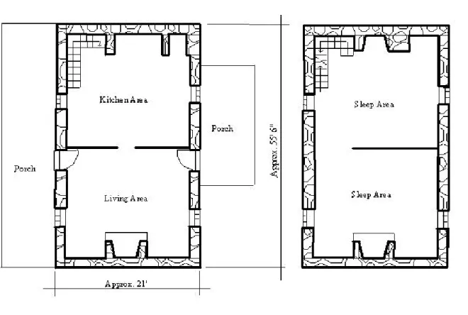
In 1856, a two-story brick addition was added to the northern side of the original limestone structure by John Allebaugh (Figures 4 and 5). If the hypothesis is supported, then it was at this time that the reorientation occurred. The north wall of this addition included two chimneys, with two fireplaces on each floor. A load-bearing wall runs through the middle of the addition from north to south to support the second floor and the attic. The existing doorway on the northerly-facing side connects the original stone structure with the new brick addition. The stone arch above this doorway was kept as support for the upper stories. The second level window on the western end of the northerly-facing side was widened to function as a doorway. The other second level window on the northerly-facing side was bricked shut, while still keeping the stone arch for support. Additionally, the windows on the northerly-facing side of the first level were both widened to function as doorways, and still retained their original arches. However, the east door was later bricked shut. There is no information regarding the stairway during this period of construction.
During the 1860s there were extensive renovations by William and Solomon Burtner to the original limestone structure, including some Greek revival influence seen in the design and woodwork (Figures 4 and 5). All four window openings on the southerly-facing side were made larger to accommodate taller and wider windows. The first level front door opening was enlarged to accommodate a taller door. The second level door opening leading onto the roof of the porch was also enlarged. At this time the stone arches above the doorway and the windows were removed because the weight distribution that they created could not accommodate a larger doorway and windows. A central hall, including a stairway, was constructed on both floors of the stone structure by removing the center partitions. This created an unheated hallway that provided
built. A new, south side porch was constructed, which was shorter than the original. An
additional window was placed on the east side of the original stone structure. The entire exterior of the structure was coated with stucco, providing a more finished look and helping to seal the walls. The original stone fireplaces and chimneys located on the east and west sides were
removed and replaced with freestanding brick fireplaces and chimneys. These chimneys were not built into the wall, but were added to the inside of the room. Following these major renovations, only minor changes occurred to the architectural form of Fort Harrison.
11
Figure 4: 1850s Addition and 1860s Renovations- First Floor Plan
The figure shows the first floor of both the 1856 brick addition added to the north side of the originial limestone structure and the 1860s renovations completed on the originial limestone structure portion of the house.
12
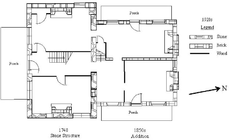
Figure 5: 1850s Addition and 1860s Renovations- Second Floor Plan
This figure shows the second floor of both the 1856 brick addition added to the north side of the original Limestone structure and the 1860s renovations completed on the originial limestone structure portion of the house.
Shenandoah Valley Settlement
In The Planting of New Virginia: Settlement and Landscape in the Shenandoah Valley, Warren Hofstra (2004) examines the initial settlement of the area and its progression from an unknown backcountry to an interconnected landscape crossing between areas of town and country. This contextual information helps to set the backdrop of the environmental, social, and economic conditions present at the time that Fort Harrison was first constructed and throughout its later periods of occupation. These conditions and mentalities would have affected human behavior, which is reflected in the architectural styles, layout, and artifact spatial patterns observed on the Fort Harrison property today.
At the beginning of the eighteenth century the Shenandoah Valley of Virginia was open, unfamiliar land. The Shenandoah Valley was a region of the southern backcountry that was one of the earliest settled and eventually became the most developed area West of the Blue Ridge Mountains by the early 1800s. Native Americans still occupied some of the area, but their habitations were increasingly uncommon beginning in the mid-seventeenth century as European settlement began and evolved in later years. The initial settlement of the Shenandoah Valley by Europeans began in the 1730s and lasted for around seventy years as the land was transformed into a developed world. Farms, roads, and markets eventually dotted the landscape among town and country as the area was altered through the institution of private property. The development and evolution of the town and country landscape west of the Blue Ridge Mountains is
understood by Hofstra (2004) through three phases, the initial European settlement in the 1730s, the establishment of counties and towns, and the increasingly interdependent landscape between the town and country spheres.
The first phase of settlement within the Shenandoah Valley of Virginia was during the 1730s, when Europeans first came to the area from other settled regions within mid-Atlantic North America. It was during this first phase of settlement that Daniel Harrison moved to the Shenandoah Valley from Delaware around 1738. Reasons for the movement of individuals from other settled areas into the region included economic pressures pushing them out, and seeking land or new opportunities. Settlement west of the Blue Ridge Mountains was further initiated by the colonial government of Virginia through the development of land policies. These land policies were set in place to help alleviate the effects of situations like threats from French encroachment on their land from the west, Native American attacks, conflicting claims to land between neighboring colonies, and threats of slave uprisings in the mountainous areas.
Families and individuals that settled the area were initially dispersed and the average land ownership ranged from three to four hundred acres. Dispersal throughout the Shenandoah Valley created rural communities, also known as open-country neighborhoods, where individual
families occupied hundreds of acres of land. The rural communities created the beginning of centrality on the landscape and were settled depending on the Europeans’ perceptions of a good farmstead location. The pattern of settlement on the land depended on multiple factors such as environmental conditions and the likelihood of the land to produce economic gain. The locations of European homesteads were often sites previously inhabited by Native Americans, suggesting that Europeans took advantage of the environmental modifications made by Native Americans, such as land clearance for the location of agricultural fields. Europeans may have also been using some of the same criteria that Native Americans were using to select suitable settlement
locations, which encompassed multiple environments that made for the best likely economic output. Homesteads consisting of a farmhouse and dependencies, such as small barns and storage
buildings, were often located in forested areas with good access to water. Forested areas were associated with good soil quality because Europeans judged the value of land based on vegetation coverage.
Dwellings during this phase if settlement were small, single roomed structures. They were often square, measuring about 20 feet on each side, and were essentially single room cabins. Log structures were built with earthen or wood floors, but stone structures were also common. Often if the early structures survived they were later incorporated into other structures. Surrounding these early dwellings were several smaller fields, which contained both gardens and crops. Fences kept free roaming animals like horses, cattle, and sheep separate from crop fields. During this initial settlement of the Shenandoah Valley the economy was focused on household production and local exchange. During this phase of settlement within the Shenandoah Valley there was a mix of ethnic backgrounds. Most populations were Scots-Irish and German, and there were some English and Anglo-Americans. This first phase of settlement ended with the establishment of Frederick and Augusta counties in 1738, which led toward the founding of county towns (Hofstra 2004).
The second phase in the settlement of the Shenandoah Valley consisted of the establishment and layout of county towns on the landscape, beginning in the years 1744 and 1745. During this evolutionary phase of settlement Daniel Harrison constructed the original limestone structure. The town of Dayton was likely beginning to emerge during this phase and the city of Harrisonburg was founded in 1780. The distinguishing factor of this stage of
settlement is not a major change in the people or economic activities, but was the establishment and the influence of the political authority. War in England caused leaders within the community
there began establishment of a landscape that allowed for the effective functioning of political organizations. The concentration of these political organizations, especially the court system was placed within county towns, where the court could serve as a large presence and exert its
influence on the surrounding areas. The towns began in the form of property lots and streets aligned on a grid system, which ultimately created a center square of public buildings. The areas surrounding the county town continued to be occupied by rural, open-country neighborhoods. Houses and farm layouts with dependencies continued to be constructed in similar fashions. During this phase economic activities of individual farms generally continued to focus on household production with some local exchange of goods like wheat and flour. As towns started to be developed, the economic activities there centered on the stores, but the court also often stimulated local trade in the town center. During the global conflict of the Seven Years War, which spanned from 1756 to 1763, the economy was stimulated due to demand of the military. Merchants from coastal areas took advantage of the economic opportunities found in the backcountry, and contributed to the expansion of economic markets and the increasing
dependence that the town and country began to have on one another. Economic developments that arose after 1760 resulted in the town and country spheres becoming even more integrated leading to the third phase of settlement and evolution within the Shenandoah Valley (Hofstra 2004).
The third phase of Shenandoah Valley settlement and evolution occurred around 1800. The first two phases of open-country and county town evolution occurred as results of political events. The third phase is the result of the occurrences in the previous two phases, which resulted in a more integrated and coherent landscape that consisted of both the town and country. The economy changed in Europe as the population increased, the Industrial Revolution began, and
agricultural yields could not support the growing population. Therefore, there were increases in food prices worldwide and stimulation in both the local and global exchange economies. Changes in Europe such as those previously mentioned led to the commercialization of the Shenandoah Valley region and the consumer revolution as individuals and families were gaining profits from selling their goods. Grain production, tobacco, and livestock constituted great sources of income for farmers within the Valley. Changes within the economy led to general prosperity and drove the town and country to become increasingly integrated and interdependent between commercial agriculture, market towns, and Atlantic ports. Due to the economic
prosperity more towns were founded and placed in locations along developing road systems such as the Valley Road, which ran north to south through the Appalachian Valley from Pennsylvania to North Carolina. Out of this development emerged a settlement configuration that included hierarchy of towns, which were integrated into the earlier landscape of open-country
neighborhoods. The increase in family wealth led to more defined social classes, including slaves. Furthermore, the prosperity led to renovations and rebuilding of structures on the landscape to better reflect the wealth of the region through Georgian and neoclassical forms. Streets and roads were merged, further establishing connections between town and country (Hofstra 2004). It was during this phase of settlement that the brick addition was added to Fort Harrison and later renovations were completed. Also during this phase was the founding of the town of Dayton in 1833 when the name was changed from Rifeville.
Shenandoah Valley Architecture
region was becoming further interdependent and developed. These architectural stages follow the different periods of settlement within the Shenandoah Valley. In A Field Guide to American Houses, Virginia and Lee McAlester (1984) state that domestic architectural buildings of the early settlement period fall between two categories: folk houses and styled houses. Folk houses are usually simple structures providing the basic need of shelter, and which are designed and built based on tradition with no conscious effort of including current styles. Two forms of vernacular architecture are hall and parlor dwellings and I-houses. Most American houses are styled houses, which are those that are designed with an attempt to include current styles. A distinct domestic building style found within the Shenandoah Valley from the middle of the 1800s is the Georgian style. This styled structure is classified based on the configuration of the first floor, while the arrangement and number of rooms on the second floor may be variable and does not affect the overall classification of the structure.
In Everyday Architecture of the Mid-Atlantic, Gabrielle Lanier and Bernard Herman (1997) examine structures and landscapes located within the Mid-Atlantic region from southern New Jersey to Virginia and interpret them through an archaeological perspective. Henry Glassie also examines typical structural forms and farm layouts found within the Delaware Valley in
Eighteenth-Century Cultural Process in Delaware Valley Folk Building (1972). The Delaware Valley shares house building styles with the Shenandoah Valley in Virginia because the Delaware Valley was one source of migration to the Shenandoah Valley via the Valley Road. Property owners, local builders, and trained architects determine architectural forms of houses based on both the natural and cultural environment at the time of construction. Architectural forms create one aspect of many cultural elements that are continuously changing within the Shenandoah Valley.
The pattern of vernacular architecture predominant within the Shenandoah Valley during the seventeenth and early eighteenth centuries was the I-house. Vernacular architecture is based on tradition, material availability, and the needs of the community. Fred Kniffen (1990) named this folk form of architecture in the 1930s, to describe a certain form popular in rural areas settled by the English in the seventeenth and eighteenth centuries. This form was thus named because of the appearance of the tall, thin gable as an upper case I. This form was found
throughout Europe prior to and during the time of settlement within North America, therefore, it was often built in the English colonies throughout the seventeenth and eighteenth centuries. During the time that the I-house form was initially being constructed, it was associated with societies containing an economy with an agricultural basis and it further indicated economic success. This form continued to be built within North America until the early 1900s, however, later after the mid 1800s it began to be increasingly associated with lower class households (Lanier and Herman 1997).
The definite characteristics of this form are two levels, one room in depth, and at least two rooms in length. In most instances, an I-house consisted of a hall and parlor design with two rooms placed side by side on the first level and a fireplace flush with the outside wall on each of the gabled ends. One room was called the hall, which was the main room of the house, and the other was the parlor, which served as a space for formal sitting and entertaining. The second level was used as a sleeping area for the inhabitants. The gable ends of the structure were usually blank, but later windows began to be incorporated. On the longer sides of the structure the doorways and windows were placed on each side of the doorways, to create a symmetrical arrangement.
Fred Kniffen (1990) explains that the I-house has a variable floor plan, which includes variation in the room dimensions and the placement of the stairway. While the form can be variable it includes the definite characteristics above, thus, it establishes a specific type within the Shenandoah Valley among other areas in the United States. The I-house type is further variable because structures are built using many material types including brick, log, and stone. The material that was chosen was due to multiple reasons including available materials, socioeconomic status, and the length of time intended for the occupation of that structure.
The I-house form is an open plan design because of the direct access that the entryway has into the dwelling’s main floor living areas. While there are variations in the I-house across the United States, within the Valley the variations of open plans within the Mid-Atlantic region were limited, with most dwellings containing one or two rooms, although there were some structures that contained open plans with up to three and four rooms. Open plan designs for houses were typical of the early periods of European settlement until the middle of the 1800s and different variations of the open plan coexisted.
The original limestone structure that was built by Daniel Harrison in 1749 was built using the two room open plan I-house form typical of the early period of initial European settlement (Figure 3). The structure possesses defining characteristics of this architectural form. It was one room in depth with two separate rooms on the first and second floors. Both of the longer sides of the structure had a doorway, with a window to either side. The gabled ends both contained fireplaces flush with the outer wall and originally had no windows. Daniel Harrison’s use of the I-house form is consistent with his position as an early settler in an agricultural society and his use of limestone material is an indicator of his higher social position, due in part to his economic success.
The early form of dwelling within the Mid-Atlantic region shifted from the open plan I-house to the closed plan Georgian I-house type (Glassie 1972). This shift occurred around the middle of the 1800s, but some early forms of the Georgian house type have been known to exist in the late 1690s. The Georgian type was inspired by the Renaissance period and classical Greek and Roman design during a time when the Mid-Atlantic region was becoming more developed, commercialized, and prosperous. When this form became more prevalent in the middle of the 1800s within the Mid-Atlantic region it was associated with affluent individuals of higher status, while the I-house hall and parlor form was increasingly associated with the less affluent.
The defining elements of the Georgian house type are a central hallway that contains the stairway and has direct access to the doorways. Typically the structure has a depth of two rooms located on either side of the central hallway. The second floor of a Georgian plan structure typically follows the same layout as the first floor, including two rooms on either side of the central hallway. There are Georgian plan structures that include more rooms on the second floor of the structure than on the first floor. There are two window openings on each floor of the gabled ends, and five openings on the longer sides of the structure, which include both doorways and windows. The doorways and windows are primarily placed in locations that are horizontally and vertically symmetrical to create a balanced form. Georgian plan structures were built in a variety of materials including log, brick, and stone.
Georgian houses are closed plans because they do not allow direct access into the living areas of the house. The front entrance in a Georgian structure has access to the central hallway, which then allows access into other rooms. A closed plan creates social distancing, separation, and control of space. This layout was popular for affluent owners of servants because of the
ability that it gave the owner to control the movement of servants within the house and through the creation of a social distance between owner and servant.
At Fort Harrison, the brick addition that was added to the north side of the original limestone structure in 1856 by John Allebaugh and the following renovations by William and Solomon Burtner in the 1860s to the original limestone structure were constructed according to the Georgian style, which was becoming more common during the middle of the 1800s (Figures 4 and 5). These changes to the structure include elements such as symmetry and proportion, which served as the basis of the Georgian form. The renovations to the original limestone building included the relocation of the corner stairway into the central hallway, which creates symmetry as well as creating a more closed floor plan with greater privacy. Renovations to existing domestic structures are often due to one or more of the following: to update the appearance, to add needed living space, and to minimize exterior maintenance. The use of structural elements by John Allebaugh and William and Solomon Burtner in the middle of the 1800s, to create a Georgian form dwelling indicates that they were changing the physical structure to update the appearance and to reflect a changing society. As the I-house hall and parlor form was becoming increasingly associated with the lower classes, Fort Harrison was altered to reflect an updated structure with the latest design elements, which reflect a fashionable family of higher status and success. The addition may have also been constructed to add needed living space to the structure, and the stucco that was applied during the renovations helped to seal the walls, therefore decreasing exterior maintenance while also providing a finished look.
Shenandoah Valley Farm Layouts
The arrangement of farmyard plans can vary for multiple reasons, but overall, functionality and geometry were key in the placement of barns and other dependencies. The types of farm buildings and their location on the land depended on other factors like the type of agriculture on the farm and regional preferences or traditions. Traditional folk plans for
farmyards had to be combined with new unfamiliar elements found within the backcountry, such as the topography and weather patterns, as well as new social and economic systems.
Henry Glassie (1972) identifies two basic farmyard plans within the Delaware Valley: the courtyard plan and the linear plan. As previously stated, the Delaware Valley is comparable to the Shenandoah Valley because many Delaware Valley people migrated south down the Valley Road into regions such as the Shenandoah Valley, bringing their architectural forms and cultural expectations with them. When either of the farmyard plans are in their ideal form they contain the same layout patterns between the house, barn, and other dependencies on the landscape. The two farmyard plans were not always vigorously applied especially when the traditional planner met a new environment. However, it is unlikely that farmyard plans were seldom random, having no linear organizational element and logical orientation. While unlikely, there were some random arrangements of farmyards, but these are most common in poorer agricultural areas. Farmyard plans are described by their relationship to the house, most often placing barns and other buildings behind the house, to the side, or across a road from the house. Different styles of houses and barns could be incorporated into the two basic farmyard plans that were recognized by Henry Glassie.
barn could also form a right angle with the ridge lines of the house. Other buildings to the side of the farmyard extend from the house to the barn and form a hollow rectangle that serves as an open work area. Buildings that are associated with the house are located closer to the dwelling, while outbuildings associated with the farm are located toward the barn. Overall this plan has the house at the front, the barn behind the house, and other outbuildings completing the hollow center courtyard area. There are a few variations of the courtyard arrangement for farmyards, such as just the house and the barn with no other outbuildings enclosing the center area. When this occurs a courtyard is implied in the space between the structures.
The linear plan is a farmyard arrangement that aligns the ridge lines of the house and the barn. The placement of these two structures is gable to gable. The arrangement of other buildings within the linear plan is a secondary courtyard arrangement that is defined by the barn, not the house. The farmyard arranged in a linear plan would often orient the front of both the house and the barn toward the south or east to maximize exposure to early morning sunlight.
Buildings present in early farmyard plans would have included the house, a small barn or stable, and other necessary outbuildings. Outbuildings were used to perform specific functions outside of the main house. This kept heavy, dangerous, dirty and odorous tasks separate from the house. Such outbuildings include detached kitchens, springhouses, dairies, smokehouses,
multipurpose buildings or shelters, and slave or servant quarters.
Both archaeology and architecture reflect aspects of past cultures through material remains. They compliment one another so that when both are used to study a landscape, a more complete understanding of its past can be determined. In the case of Fort Harrison,
archaeological investigation lends itself to studying the changes in architectural orientation over time.
Previous Archaeology
Beginning in the spring of 2016, Fort Harrison, Inc. invited the Department of
Anthropology at James Madison University to perform exploratory archaeological fieldwork with the goal of gaining insight into the everyday life of occupants at Fort Harrison. Initially, Fort Harrison, Inc. wanted to search for the legendary tunnel that supposedly led from the house to the nearby spring during the French and Indian war from 1756 to 1763. When no evidence was found for a tunnel, a comprehensive exploration of the immediate landscape was
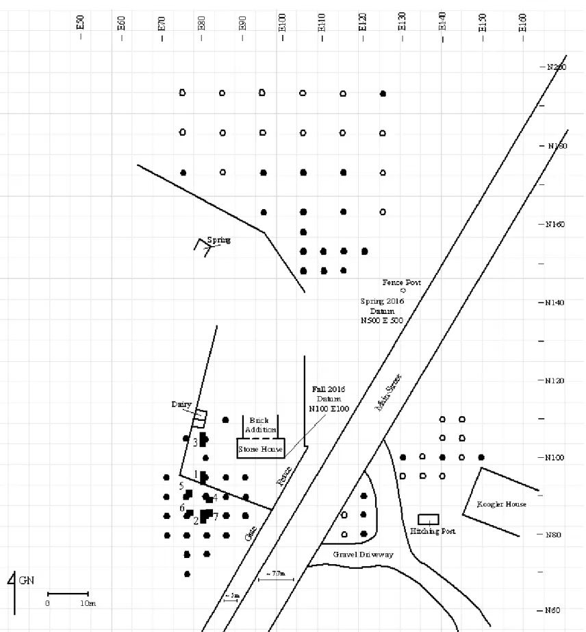
undertaken. When unexpected concentrations of early artifacts were recovered from the south side of the structure, focus was then concentrated within this area. Since then, there have been four periods of archaeological fieldwork performed by students enrolled in both the Historical Archaeology course (ANTH/HIST 331) and the Archaeology course (ANTH 197) under the direction of Dennis Blanton (Figures 6 and 7). The first occurred in the spring of 2016 and was focused within the cultivated field, to the north of the house. During this period 30 shovel test pits were excavated. The second was conducted in the fall of 2016 and was focused in the southern yard of the house and within the pasture to the south. A total of 14 shovel test pits and three units were excavated. The third occurred in the spring of 2017, and consisted of 17 shovel tests filling in areas within the southern yard, the pasture to the south, and to the east of the stone house across Main Street. Finally, the fourth occurrence of archaeological fieldwork took place this past fall and was focused in the pasture to the south of the house. During this period four units were excavated.
Excavation Procedures
The initial stage of archaeological work performed in the spring of 2016 involved 30 shovel test pits measuring 30 cm in diameter placed within the cultivated field, to the north of the house. The shovel test pits were laid out according to a fence post datum located at N 500, E 500, and placed at either 10 m or 5 m intervals.
The archaeological work in fall of 2016 involved 14 shovel test pits measuring 30 cm in diameter located in the southern yard of the house and within the pasture to the south. This area includes areas inside the current picket fence and outside the fence in the pasture to the south. Shovel test pits were laid out in 5 m intervals in the vicinity to the southwest of the existing house based on a reference baseline and datum at the corner of the original stone house designated as N 100, E 100. The placement of three units measuring 2 m by 0.5 m was determined based on the results from the shovel test pits. The goal of unit excavation was to further investigate areas within the yard and southern pasture that yielded an abundant amount of artifacts and features.
Archaeological work in the spring of 2017 consisted of 17 shovel test pits measuring 30 cm in diameter placed across the site in areas previously not investigated in order to determine the location of activity areas and to perform a comprehensive spatial analysis of the entire site. Such areas were located across Main Street in the Koogler’s front yard, to the east of the
structure. Additionally, areas within the pasture to the south of the structure were filled in based on the locations of previous shovel test pits.
The final archaeological excavation procedure consisted of four units measuring 1 m by 1 m within the pasture to the south. Units were placed according to the results from the previous
excavation periods. Shovel test pits where features were documented and those that contained an abundance of early artifacts were chosen for unit excavation.
All shovel test pits were excavated until subsoil was reached using shovel and trowel. Unit excavation involved the removal of soil with shovel and trowel according to natural soil levels until contact with subsoil. All soil was sifted through ¼ inch dry screen and artifacts bagged. Unit profiles and plan views were drawn, and the unit photographed. As features were identified they were exposed, drawn, and photographed. Soil was described using standard terminology and Munsell soil color.
With a goal of defining the boundaries of a feature identified in Unit 7 within the pasture to the south, two small test trenches were examined and some soil core samples were taken using an Oakfield soil sampler.
Following fieldwork all artifacts were taken to the James Madison University archaeology laboratory for washing, identification, cataloguing, and analysis. Using the
AutoSketch drawing program, the site map, unit plan views, and unit profiles were converted to digital format.
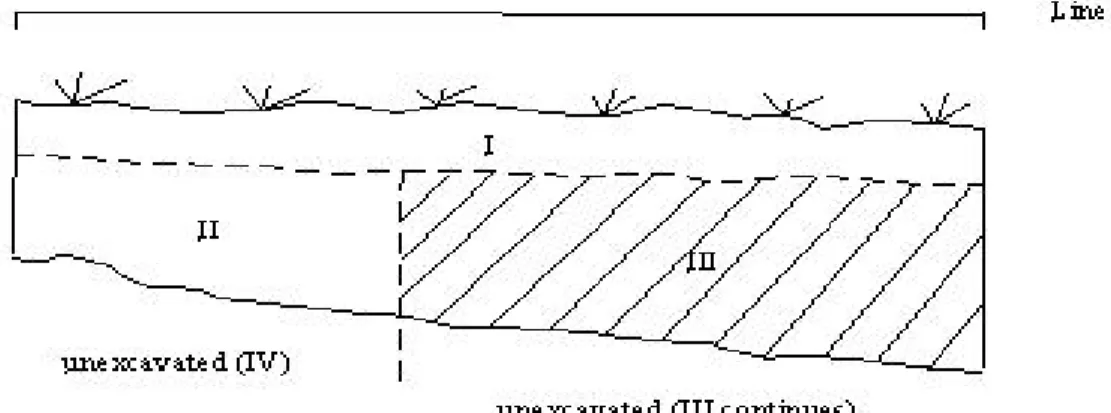
Stratigraphy & Integrity
The stratigraphy of the shovel test pits and units generally progressed through the horizon topsoil at the surface, the E-horizon, and the B-horizon subsoil. The color of the A-horizon topsoil had a dark grayish brown color and was a silty loam. The E-A-horizon ranged from primarily brown to a more dark brown, dark gray, or yellowish color. The texture of the E-horizon ranged from a silty loam to a silty clay loam with abundant small stones or pebbles. The
Differences in the general pattern of soil transitions from A-horizon to E-horizon to B-horizon took place when features were identified (Figures 9 and 14) and when the soil had been backfilled (Figures 8 and 10). The abundance of small pebbles and stone increased with depth within the southern pasture. Differences in depth among the shovel test pits until subsoil was reached spanned from less than 10 cm at the shallowest and around 80 cm for the deepest. Refer to the figures illustrating the unit profiles for specific information on strata, Munsell color, and soil texture.
Interpretation of archaeological data relies on a few key principles. First, the location of artifacts within the stratigraphic sequence correlates to their age. The law of superposition states that in an undisturbed sequence of strata, the youngest stratum is at the top and the oldest stratum at the bottom. Therefore, in an undisturbed landscape artifacts recovered within the top strata are younger than artifacts recovered in the bottom strata. Second, the absolute or calendar dates for strata can be determined by the artifacts within them. Ceramic and nail types are useful artifacts to provide a date range of occupation within certain strata because of their known manufacturing dates according to certain attributes. The period of site occupation that correlates with the most common ceramic and nail types recovered is from the mid-1700s to the mid-1800s, which is concentrated in stratum II. The large concentrations of artifacts within stratum II indicates that this was the most intensive period of site occupation at the locations of the five units in the southern pasture.
Figure 10: Unit 3 East Profile
The archaeological integrity of areas surrounding Fort Harrison is generally good. The integrity refers to the degree that the site has been disturbed and therefore, loses its
archaeological validity. Modern day activities and erosion are the two factors that have likely influenced the site’s archaeological integrity. The topmost stratum is of little to no value because of the degree of disturbance of the soil and the presence of modern day materials due to recent activities. The cultivated field to the north of the dwelling has undergone alterations like plowing and fertilizing to prepare for the growing of crops, thus the integrity of the top stratum is low. The pasture to the south of the dwelling has been used as an area for grazing cattle, also compromising the integrity of the topmost stratum.
Unit 4, Unit 5, and Unit 6 within the southern pasture likely suffered from the issue of deflation from soil erosion. Deflation is a process where wind and other natural forces transport sediment to another location. While this does not affect the artifacts, it causes the thickness of soil deposits to change over time as they shift within the area. Unit 5 is located toward the top of a small hill, while Unit 6 is located directly south and downhill. Within Unit 6 most artifacts are located in stratum III, while the majority of artifacts within other units are located within stratum II. This indicates that erosion caused another stratum of soil to gradually be deposited from the area of Unit 5 to the area of Unit 6. Based on the artifact types the time period of stratum III within Unit 6 correlates to the time period of stratum II among the other units. The same process affected Unit 4, which is also located toward the top of a small hill.
Archaeological Results- Shovel Test Pits
The four occasions of archaeological fieldwork included excavation of 61 shovel test pits in areas of the northern cultivated field, the yard, the southern pasture, and in the Koogler’s yard across Main Street to the east (Figures 6 and 7).
Artifacts
The types of artifacts that were recovered at Fort Harrison fall among the following main categories: ceramics, nails, glass, brick, bone, and miscellaneous. Within those categories the artifacts can be subdivided further. Ceramics fall between two main categories: coarse
earthenware and refined earthenware. Coarse earthenwares such as redware are fired at
temperatures between 900 and 1,200 degrees Celsius and are the softest type of ceramic finished with a variety of surface treatments. Refined earthenwares include types such as creamware, pearlware, and whiteware. Refined earthenwares are fired at higher temperatures between 1,100 to 1,200 degrees Celsius and usually are finished with a glazed surface. Nails can be further categorized into hand wrought, machine cut, and wire based on their mode of manufacture. Glass types are distinguished between window glass and bottle glass. Any type of artifact that does not fit within a large category falls within miscellaneous. At Fort Harrison this includes metal fragments, buttons, a straight pin, and percussion caps.
Recovered artifacts are significant because they give information regarding the past activities that occurred on the site. Ceramics and nails are important artifacts because they have unique attributes, which allow them to be more easily dated.
Northern Cultivated Field Artifacts
Within the northern cultivated field there were a total of 30 shovel test pits. Among the 30 total test pits, 15 yielded no artifacts. The total number of artifacts recovered for the
remaining 15 shovel test pits is 269 (Tables 2 and 3). The most abundant types of artifacts are brick fragments and bone fragments. Less abundant, but still numerous are redware sherds, refined earthenware sherds, bottle glass fragments, window glass fragments, and hand wrought and cut nails. One porcelain sherd was recovered (Figure 15). Within the recovered refined earthenwares, whiteware was the most common, followed by pearlware, then creamware. The temporal patterns of these artifacts are discussed in the next section.
Table 2: Shovel Test Pit Artifact Types
Northern Cultivated Field
Location Ceramics Nails Window Glass
Bottle
Glass Bone Brick Total
SP 1 1 35 1 37 SP 2 8 1 1 5 14 29 SP 3 6 5 2 2 10 25 SP 4 1 1 SP 5 1 1 SP 6 11 1 3 6 4 23 48 SP 7 5 3 4 3 3 16 34 SP 8 4 2 2 1 8 17 SP 9 10 1 1 2 1 19 34 SP 10 5 2 2 1 3 13 SP 11 1 1 SP 12 2 3 15 20 SP 13 SP 14 SP 15 SP 16 2 5 6 SP 17 1 1 SP 18 SP 19 SP 20 SP 21 SP 22 SP 23 SP 24 SP 25 SP 26 SP 27 SP 28 SP 29 SP 30 1 1 Total 54 11 16 20 51 116 269
Table 3: Shovel Test Pit Refined Earthenware and Nail Types
Northern Cultivated Field
Location Creamware Pearlware Whiteware
Hand Wrought
Nails Cut Nails
SP 1 1 SP 2 1 4 1 SP 3 1 1 SP 4 SP 5 SP 6 2 4 1 SP 7 2 1 SP 8 1 2 SP 9 1 5 1 SP 10 1 1 SP 11 SP 12 SP 13 SP 14 SP 15 SP 16 1 SP 17 SP 18 SP 19 SP 20 SP 21 SP 22 SP 23 SP 24 SP 25 SP 26 SP 27 SP 28 SP 29 SP 30
Figure 15: Northern Cultivated Field Artifact Type Percentages Refined
Earthenware
Redware
Window Glass Hand Wrought &
Cut Nails
Bone Brick
Bottle Glass Porcelain
Yard and Southern Pasture Artifacts
The yard south of the dwelling within the current picket fence and the pasture outside the fence included 25 shovel test pits. All of the shovel test pits contained artifacts and the total number recovered is 610 (Tables 4 and 5). The most abundant types of artifacts were redware sherds and refined earthenware sherds. Other artifact types that were still largely present but less abundant in this area of the site are brick fragments, bone fragments, hand wrought and cut nails, bottle glass fragments, and window glass fragments. No porcelain was recovered. In addition to the brick fragments, hand wrought and cut nails, and window fragments, another type of
architectural material that was recovered was other stone, such as limestone. In addition to bone there are some shell fragments recovered from the shovel test pits in the south yard and the southern pasture. Rare items are included in the miscellaneous category, which includes pipe stem and bowl fragments, button, buckle fragment, spring clip, fastener ring, slate, and tin can sheet metal (Figure 16).
Table 4: Shovel Test Pit Artifact Types
Yard and Southern Pasture
Location Ceramics Nails
Window Glass
Bottle
Glass Bone Brick Shell
Pipe
Frag. Misc. Total ST 1 10 4 1 7 12 5 39 ST 2 35 4 3 1 1 3 1 48 ST 3 8 6 4 5 3 8 1 1 36 ST 4 3 5 10 2 5 25 ST 5 2 9 1 1 13 ST 6 4 2 3 1 1 11 ST 7 40 5 1 2 12 2 1 1 64 ST 8 1 2 1 7 11 ST 9 31 1 11 5 1 49 ST 10 3 3 2 3 2 13 ST 11 9 2 5 2 1 1 20 ST 12 18 1 1 2 9 31 ST 13 16 3 1 3 14 1 1 39 ST 14 29 6 6 6 3 11 1 62 ST 54 14 4 2 20 ST 55 7 3 1 22 33 ST 56 4 1 5 ST 58 1 1 2 ST 59 2 2 ST 62 5 1 1 1 8 ST 63 9 2 11 ST 64 18 1 1 20 ST 65 9 3 1 13 ST 66 3 2 2 7 ST 68 15 1 1 4 7 28 Total 295 55 37 43 74 88 7 1 10 610
Table 5: Shovel Test Pit Refined Earthenware and Nail Types
Yard and Southern Pasture
Location Creamware Pearlware Whiteware
Hand Wrought
Nails Cut Nails Total
ST 1 1 7 1 3 12 ST 2 18 10 1 3 32 ST 3 1 2 3 3 9 ST 4 1 2 1 4 8 ST 5 2 2 ST 6 3 1 2 6 ST 7 19 5 2 3 29 ST 8 0 ST 9 6 2 2 10 ST 10 1 2 3 6 ST 11 2 2 2 2 8 ST 12 1 3 2 1 7 ST 13 2 1 1 2 6 ST 14 4 2 4 10 ST 54 1 1 1 3 6 ST 55 1 2 3 ST 56 0 ST 58 1 1 ST 59 0 ST 62 1 1 ST 63 3 3 ST 64 2 3 3 1 9 ST 65 2 1 1 4 ST 66 0 ST 68 2 1 1 1 5 Total 19 61 44 20 33 177
Figure 16: Yard and Southern Pasture Artifact Type Percentages Refined Earthenware Redware Window Glass Hand Wrought
& Cut Nails Bone
Brick
Bottle Glass Shell
Koogler Yard Artifacts
Within the Koogler family’s yard to the east of Fort Harrison across Main Street there were six shovel test pits. Among the six total test pits, four yielded no artifacts. The total number of artifacts recovered in this area of the site is four (Table 6). Half of the artifacts were redware sherds, followed by a refined earthenware sherd and a window glass fragment. No artifacts were recovered from the remaining types.
Table 6: Shovel Test Pit Artifact Types
Koogler Yard
Location Ceramics Nails Window Glass Bottle Glass Bone Brick Total
ST 52 ST 53 ST 57 ST 60 ST 61 1 1 ST 67 2 1 3 Total 3 1 4
Figure 17: Redware Fragment Figure 18: Feather Edge Creamware Fragment
Figure 19: Shell Edge Whiteware Figure 20: Pearlware Fragment Fragment
Figure 21: Cut Nails
Figure 22: Window Glass Fragments
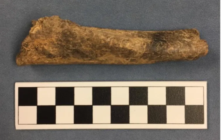
Figure 24: Bone Fragment
Figure 27: Bone Button and Milk Glass Button
Artifact Distributions
The distribution and densities of artifact types in different areas of the site varies and reveals changing spatial patterns over time. Areas with high artifact densities correlate with more intense past activity, while areas of low artifact densities suggest less past activity. The type of artifact also indicates the type of activity occurring at a specific location on the site. Furthermore, the type of artifact indicates the manufacturing period, which thus reveals the time period in which that area of the site was used. Among the shovel test pits the highest density of total artifacts is within the yard and the adjacent southern pasture. There is also a higher density of artifacts in the southern portion of the cultivated field to the north of the dwelling. In contrast, areas of low artifact densities are the northern portion of the cultivated field and east of the dwelling across Main Street in the Koogler’s yard.
The shovel test pits that have the highest total number of artifacts recovered are 7 and 14 (Table 4). These shovel test pits are located adjacent to one another within the southern pasture and are aligned according to their eastern coordinate (Figure 7). Shovel test pit 7 contains continuously high numbers of artifacts among all of the types. Categories of artifact types that have the highest numbers of artifacts recovered are ceramic, bone, and nails. The distributions of these three artifact types are concentrated within the shovel test pits located within the southern pasture. Shovel test pit 2 within the yard to the west of the dwelling also has a high concentration of ceramics.
The following is a chronological ordering of the artifact types with known manufacturing dates, their concentrations, and their distributions across the site. Over time ceramic wares develop from types of coarse earthenware to types of refined earthenware, and nail types develop
with known manufacturing dates, the distribution of other artifact types, such as bone fragments and architectural material like window glass and brick fragments are examined.
The coarse earthenware type that is most abundant is redware (1701-1800). The
distribution of redware is highly concentrated within the southern pasture at the same location as the concentration of refined earthenware. Redware also has a high concentration in the yard to the west of the dwelling.
Refined earthenware can be broken into the following chronological categories: creamware (1760-1820), pearlware (1779-1830), and whiteware (1820-present). Within the southern pasture and the yard where there are the highest densities of refined earthenware, the distributions of creamware, pearlware, and whiteware are different. The distribution of
creamware is more concentrated within the southern pasture to the south of the dwelling (Figure 29). The distribution of pearlware is to the west of the dwelling (Figure 30). The distribution of whiteware is to the north west of the dwelling (Figure 31). This change in refined earthenware distribution across the site, beginning in the pasture south of the dwelling and shifting north west of the dwelling, indicates that activity areas surrounding the dwelling changed over time.
Creamware, the earliest manufactured refined earthenware type is densely distributed in the area south of the dwelling. Whiteware, the latest manufactured refined earthenware type is more densely distributed in the area to the north of the dwelling. Pearlware, the refined earthenware type that was manufactured between creamware and whiteware is most densely distributed in the area to the west of the dwelling. Thus, this indicates that the earlier activity areas were located to the south of the dwelling and later activity areas were shifted to a location north of the dwelling.
Figure 29: Shovel Test Pit Creamware Distribution
This figure shows the distribution of creamware that was recovered from the shovel test pits. The highest density of creamware is located south of the house, which is represented by the cube.
Figure 31: Shovel Test Pit Whiteware Distribution
This figure shows the distribution of whiteware that was recovered from the shovel test pits. The highest density of whiteware is located north of the house, which is represented by the cube.
Nails are another artifact type that have known manufacturing dates based on specific characteristics. The nail types that were recovered were hand wrought (before 1800) and
machine cut (1801-1900). The distribution of the highest concentration of both hand wrought and cut nails is within the southern pasture and the south yard (Figure 32).
Other architectural materials that were recovered include window glass, brick fragments, and limestone. The distribution of the highest concentrations of window glass fragments
corresponded with the highest concentrations of hand wrought and cut nails. Brick fragment distribution was both in the area to the west of the brick addition to the dwelling and in the pasture to the south of the dwelling.
Figure 32: Shovel Test Pit Hand Wrought and Cut Nail Distribution
This figure shows the distribution of hand wrought and cut nails recovered from the shovel test pits. The highest density of nails is located to the west and south of the house, which is represented by the cube.
In addition to those artifact types with known manufacturing dates are animal bone fragments. One shovel test pit in the cultivated field and three shovel test pits within the southern pasture were where the most animal bone fragments were recovered (Tables 2 and 4). The distributions of the highest concentrations of bone fragments within the southern pasture are within the same area as the highest distributions of creamware. The majority of the shell
fragments that were recovered are mussel shells and their distribution is most high in the area of the southern pasture (Table 4).
Archaeological Results- Unit Excavation
The four occasions of archaeological fieldwork included excavation of seven units located in both the yard and the southern pasture. Units 1, 2, and 3 measured 2 m by 0.5 m and Units 4, 5, 6, and 7 measured 1 m by 1 m. The placement of units in specific locations was based on the shovel test pit results and any results from previously excavated units. Areas were targeted which yielded large concentrations of early artifacts and features. Among all of the units, each one contained artifacts and additionally every stratum within each unit produced artifacts.
Artifacts
Within all of the units across the site, artifact types of varying counts were recovered in every unit and also among all the strata (Table 7). While artifacts were recovered in all strata, not every type of artifact was recovered in every stratum or every unit. As previously stated in the stratigraphy section, units generally progressed through the A-horizon topsoil at the surface, the E-horizon, and the B-horizon subsoil. There were additional strata in the units where features
silty loam. The E-horizon ranged from primarily brown to more dark brown, dark gray, or yellowish. The texture of the E-horizon ranged from a silty loam to a silty clay loam with
abundant small stones or pebbles. The B-horizon subsoil ranged from yellowish brown to strong brown and had a clay texture. The abundance of small pebbles and stone increased with depth within the southern pasture. Artifacts were most abundant in stratum II of every unit. Units 7, 2, and 6 had the most total artifacts recovered. These three units are aligned along the north 85 coordinate (Figure 7). The most prominent artifact types were brick fragments, animal bone fragments, coarse earthenware, and refined earthenware (Table 7). Within the coarse earthenware type, redware was highly abundant. The most abundant refined earthenware type was pearlware, followed by whiteware, then creamware (Table 8 and Figure 33). Unit 2 had consistently high counts of all refined earthenware types and Unit 5 had low counts of each refined earthenware type (Figure 33). Hand wrought and cut nails were less abundant but still prominent within the units. Machine cut nails were the most abundant followed by hand wrought nails (Table 8 and Figure 34). Units 2, 7, and 3 had high numbers of hand wrought and machine cut nails (Figure 34). Window glass fragments followed nails in their abundance and were more abundant than bottle glass. Artifact types of low abundance include pipe fragments, shell, and miscellaneous items. Among the rare miscellaneous items there are buttons, sheet metal, a horseshoe, a straight pin, and a shoe buckle fragment.
The following tables show the seven units and the corresponding strata within each. Table 7 is a summary of all the major artifact types and the count of each recovered. It shows that Units 7, 2, and 6 have the most artifacts and further breaks down the count of each artifact type. Unit 5 has the least amount of artifacts present. Table 8 further breaks down the refined earthenware and nail types into categories. Porcelain is also included, but is considered a
separate ceramic type apart from either coarse or refined earthenware. Unit 2 and Unit 7 have the highest numbers of refined earthenware as well as the highest counts of hand wrought and
machine cut nails. The highest counts of artifacts are continuously located within Units 2 and 7, therefore targeting this area on the site as being the location of more intense past activity.
60
Table 7: Unit and Level Artifact Types
Location Unit, Level Refined Earthenware Coarse Earthenware Nails Window Glass Bottle
Glass Bone Brick Shell
Pipe
Frag. Misc. Total 15 U1, LI 6 1 11 6 12 47 1 2 86 18 U1, LIB 6 3 8 16 8 11 78 2 9 141 19 U1, LII 18 16 10 4 32 29 2 111 Total 30 20 18 31 14 55 154 3 2 11 338 16 U2, LI 7 11 5 6 3 4 4 40 20 U2, LII 80 104 26 23 15 72 106 4 10 440 Total 87 115 31 29 18 76 110 0 4 10 480 17 U3, LI 5 3 2 3 5 4 14 1 3 40 21 U3, LII 42 26 29 15 14 29 5 2 3 165 Total 47 29 31 18 19 33 19 0 3 6 205 70 U4, LI 21 21 5 6 7 20 16 96 74 U4, LII 22 13 10 8 9 23 32 2 119 Total 43 34 15 14 16 43 48 0 0 2 215 71 U5, LI 1 2 2 7 5 4 23 2 46 75 U5, LII 1 2 3 1 5 13 2 27 Total 1 3 4 10 6 9 36 0 0 4 73 72 U6, LI 4 2 10 3 16 7 42 76 U6, LII 2 4 2 1 2 4 1 2 18 78 U6, LIII 35 63 17 8 10 72 84 1 2 292 Total 37 71 21 19 15 92 92 1 0 4 352 73 U7, LI 10 15 6 2 7 25 65 77 U7, LII 65 77 28 20 5 138 115 5 5 458 Total 75 92 34 22 5 145 140 0 5 5 523 Grand Total 320 364 154 143 93 453 599 4 14 42 2186
61
Table 8: Unit and Level Refined Earthenware and Nail Types
Unit, Level Creamware Pearlware Whiteware Porcelain
Total Ref. Eware Hand Wrought Nails Cut Nails Total Nail U1, LI 3 3 6 U1, LIB 4 2 2 6 2 6 8 U1, LII 1 9 8 18 3 7 10 Total 5 14 11 2 30 5 13 18 U2, LI 2 5 7 5 5 U2, LII 20 35 25 80 13 33 46 Total 22 40 25 0 87 13 38 51 U3, LI 1 3 1 5 2 2 U3, LII 3 16 23 1 42 9 20 29 Total 4 19 24 1 47 9 22 31 U4, LI 19 2 21 2 3 5 U4, LII 7 13 2 22 3 7 10 Total 7 32 4 0 43 5 10 15 U5, LI 1 1 2 2 2 U5, LII 2 2 Total 1 0 1 0 2 0 4 4 U6, LI 2 2 U6, LII 1 1 2 2 2 U6, LIII 10 9 16 2 35 1 16 17 Total 11 9 17 2 37 1 20 21 6
Figure 33: Refined Earthenware Type Percentages
Percentages according to refined earthenware type total counts. 0 0.05 0.1 0.15 0.2 0.25 0.3 0.35
Unit 1 Unit 2 Unit 3 Unit 4 Unit 5 Unit 6 Unit 7
Pe rc en ta ge Location Creamware Pearlware Whiteware
Figure 34: Nail Type Percentages
Percentages according to nail type total counts.
0 0.05 0.1 0.15 0.2 0.25 0.3 0.35
Unit 1 Unit 2 Unit 3 Unit 4 Unit 5 Unit 6 Unit7
P erc entag e Location Wrought Cut