Natural Resources Conservation Service
Santa Monica
Mountains
National
Recreation Area,
California
the Interior, National Park ServiceGeneral Soil Map
The general soil map, which is a color map, shows the survey area divided into groups of associated soils called general soil map units. This map is useful in planning the use and management of large areas.
To find information about your area of interest, locate that area on the map, identify the name of the map unit in the area on the color-coded map legend, then refer to the section General Soil Map Units for a general description of the soils in your area. Detailed Soil Maps
The detailed soil maps can be useful in planning the use and management of small areas.
To find information about your area of interest, locate that area on the Index to Map
Sheets. Note the number of the map sheet and turn to that sheet. Locate your area of interest on the map sheet. Note the map unit symbols that are in that area. Turn to the Contents, which lists the map
units by symbol and name and shows the page where each map unit is described. The Contents shows which table has data on a specific land use for each detailed soil map unit. Also see the Contents for sections of this publication that may address your specific needs.
National Cooperative Soil Survey
This soil survey is a publication of the National Cooperative Soil Survey, a joint effort of the United States Department of Agriculture and other Federal agencies, State agencies including the Agricultural Experiment Stations, and local agencies. The Natural Resources Conservation Service (formerly the Soil Conservation Service) has
leadership for the Federal part of the National Cooperative Soil Survey. Major fieldwork for this soil survey was completed in 2001. Soil names and descriptions were approved in 2001. Unless otherwise indicated, statements in this publication refer to conditions in the survey area in 2001. This survey was made cooperatively by the Natural Resources Conservation Service and the United States Department of the Interior, National Park Service. The survey is part of the technical assistance furnished to the Ventura County and Santa Monica Mountains Resource Conservation Districts.
Soil maps in this survey may be copied without permission. Enlargement of these maps, however, could cause misunderstanding of the detail of mapping. If enlarged, maps do not show the small areas of contrasting soils that could have been shown at a larger scale.
The most current soil information and interpretations for this survey area are available either through the Soil Data Mart or in the Field Office Technical Guide (FOTG) at the local field office of the Natural Resources Conservation Service. The Soil Data Mart is the Natural Resources Conservation Service data storage site for the official soil survey information. The FOTG is linked to the Soil Data Mart; therefore, the same information is available from both sources. Soil survey maps and tabular data can be accessed through the Soil Data Mart at http://soildatamart.nrcs.usda.gov. The official soil survey information stored at the Soil Data Mart and this soil survey report are also available through Web Soil Survey at http://soils.usda.gov/survey.
Nondiscrimination Statement
The U.S. Department of Agriculture (USDA) prohibits discrimination in all its programs and activities on the basis of race, color, national origin, age, disability, and where applicable, sex, marital status, familial status, parental status, religion, sexual
orientation, genetic information, political beliefs, reprisal, or the fact that all or a part of an individual’s income is derived from any public assistance program. (Not all prohibited bases apply to all programs.) Persons with disabilities who require alternative means for communication of program information (Braille, large print, audiotape, etc.) should contact USDA’s TARGET Center at (202) 720-2600 (voice and TDD). To file a complaint of discrimination, write to USDA, Director, Office of Civil Rights, 1400 Independence Avenue, S.W., Washington, D.C. 20250-9410 or call (800) 795-3272 (voice) or (202) 720-6382 (TDD). USDA is an equal opportunity provider and employer.
Citation
The correct citation for this survey is as follows:
United States Department of Agriculture, Natural Resources Conservation Service. 2006. Soil survey of Santa Monica Mountains National Recreation Area, California. Accessible online at: http://soils.usda.gov/survey/printed_surveys/.
Cover Caption
View of Castro Peak, showing an uplifted sandstone fin surrounded by Sumiwawa soils.
Contents
How To Use This Soil Survey ... i
Contents ... iii
Foreword ... vii
General Nature of the Survey Area ... 1
History and Development ... 1
Physiography, Relief, and Drainage ... 3
Water Supply ... 4 Agriculture ... 5 Altered Soils ... 5 Fire History ... 6 Soil Slippage ... 6 Climate ... 7
How This Survey Was Made ... 9
Survey Procedures ... 10
General Soil Map Units ... 13
1. Sulfic Fluvaquents-Camarillo-Pacheco association, 0 to 2 percent slopes .... 13
2. Chumash-Malibu-Boades association, 30 to 75 percent slopes ... 14
3. Cotharin-Talepop-Rock outcrop complex, 30 to 75 percent slopes ... 15
4. Mipolomol-Topanga-Sapwi association, 30 to 75 percent slopes ... 16
5. Zumaridge-Rock outcrop-Kawenga association, 30 to 75 percent slopes ... 17
6. Linne-Gaviota-Los Osos complex, 30 to 75 percent slopes ... 18
7. Botella-Cropley-Urban land complex, 0 to 9 percent slopes ... 19
8. Balcom-Xerorthents, landscaped-Urban land complex, 0 to 75 percent slopes ... 20
9. Cumulic Haploxerolls-Elder-Fluvaquents complex, 0 to 9 percent slopes ... 21
10. Urban land-Xerorthents, landscaped complex, 0 to 9 percent slopes ... 22
Detailed Soil Map Units ... 23
100—Chumash-Boades-Malibu association, 30 to 75 percent slopes ... 24
101—Chumash-Boades-Malibu association, 5 to 15 percent slopes ... 27
110—Malibu-Chumash-Boades association, 15 to 50 percent slopes ... 29
120—Mipolomol-Topanga association, 30 to 75 percent slopes ... 32
121—Mipolomol-Topanga-Rock outcrop complex, 30 to 75 percent slopes ... 34
122—Calcic Haploxerepts-Mollic Haploxeralfs association, 30 to 75 percent slopes ... 36
130—Camarillo loam, coastal, 0 to 2 percent slopes ... 38
140—Sulfic Fluvaquents, frequently flooded, 0 to 1 percent slopes ... 39
150—Abaft-Beaches association, 0 to 5 percent slopes ... 40
151—Abaft-Beaches-Urban land complex, 0 to 5 percent slopes ... 42
160—Xerorthents, landscaped, 0 to 9 percent slopes ... 43
170—Cotharin clay loam, 30 to 75 percent slopes ... 44
171—Cotharin loam-Rock outcrop complex, very bouldery, 30 to 75 percent slopes ... 46
175—Cotharin-Talepop association, 30 to 75 percent slopes ... 47
176—Cotharin-Talepop association, 15 to 50 percent slopes ... 49
179—Cotharin loam, 30 to 75 percent slopes, dry ... 54
180—Pits and Dumps ... 55
190—Kayiwish association, 0 to 9 percent slopes ... 56
191—Kayiwish association, 9 to 30 percent slopes ... 58
200—Cumulic Haploxerolls, 0 to 9 percent slopes ... 60
202—Fluvaquents-Riverwash complex, 0 to 5 percent slopes ... 61
220—Elder fine sandy loam, coastal, 0 to 2 percent slopes ... 62
230—Cotharin-Talepop association, 15 to 50 percent slopes ... 64
231—Talepop-Rock outcrop complex, 30 to 75 percent slopes ... 66
240—Tongva-Cotharin-Rock outcrop complex, 30 to 75 percent slopes ... 67
241—Cotharin-Rock outcrop-Tongva complex, 30 to 75 percent slopes ... 69
250—Urban land-Xerorthents, landscaped, complex, 0 to 5 percent slopes ... 72
251—Urban land-Tongva complex, 0 to 15 percent slopes ... 73
252—Urban land-Xerorthents, landscaped, complex, rarely flooded, 0 to 5 percent slopes ... 74
270—Pacheco silty clay loam, 0 to 2 percent slopes ... 76
290—Topanga-Mipolomol-Sapwi association, 30 to 75 percent slopes ... 77
300—Zumaridge-Kawenga association, 30 to 75 percent slopes ... 79
301—Zumaridge-Kawenga association, 15 to 50 percent slopes ... 82
302—Zumaridge-Rock outcrop-Sumiwawa complex, very stony, 15 to 50 percent slopes ... 84
303—Zumaridge-Rock outcrop-Sumiwawa complex, very stony, 30 to 75 percent slopes ... 86
304—Zumaridge-Sapwi-Kawenga association, bouldery, 30 to 75 percent slopes ... 88
305—Zumaridge-Rock outcrop complex, bouldery, 30 to 75 percent slopes ... 91
310—Gaviota stony sandy loam, 30 to 50 percent slopes ... 92
311—Gaviota-Rock outcrop association, 50 to 100 percent slopes ... 94
320—Botella loam, 2 to 9 percent slopes ... 95
330—Linne-Los Osos-Haploxerepts association, 30 to 75 percent slopes ... 96
331—Linne silty clay loam, 15 to 50 percent slopes ... 99
332—Linne silty clay loam, 9 to 15 percent slopes ... 100
350—Los Osos clay loam, 30 to 50 percent slopes ... 101
390—Danville-Urban land complex, 0 to 9 percent slopes ... 103
391—Danville-Urban land complex, 9 to 15 percent slopes ... 104
400—Pachic Argixerolls, coastal, 30 to 75 percent slopes ... 105
410—Lockwood-Urban land complex, 0 to 15 percent slopes ... 107
411—Lockwood-Urban land complex, 0 to 9 percent slopes ... 108
430—Cropley clay, 2 to 9 percent slopes ... 109
431—Cropley association, 2 to 15 percent slopes ... 110
432—Cropley clay, 0 to 2 percent slopes ... 112
433—Cropley, coastal-Urban land-Haploxererts complex, 0 to 30 percent slopes ... 114
434—Cropley, coastal-Xerorthents, landscaped-Urban land complex, 0 to 9 percent slopes ... 116
450—Sapwi loam, 30 to 75 percent slopes ... 118
451—Urban land-Sapwi complex, 0 to 50 percent slopes ... 119
460—Typic Haploxerepts, 30 to 50 percent slopes ... 121
461—Typic Haploxerepts, 15 to 30 percent slopes ... 122
470—Sumiwawa-Hipuk-Rock outcrop complex, 30 to 75 percent slopes ... 123
472—Rock outcrop-Sumiwawa-Hipuk complex, 30 to 75 percent slopes ... 126
500—Balcom silty clay loam, 30 to 50 percent slopes ... 128
503—Balcom-Balcom, dark surface association, 30 to 75 percent slopes ... 129
531—Xerorthents-Urban land-Balcom complex, 0 to 15 percent slopes ... 133
532—Xerorthents-Urban land-Pachic Argixerolls, gullied complex, 0 to 30 percent slopes ... 135
540—Calcic Argixerolls, 30 to 75 percent slopes ... 137
550—Dam ... 139
W—Water ... 139
Use and Management of the Soils ... 141
Interpretive Ratings ... 141
Rating Class Terms ... 141
Numerical Ratings ... 141
Land Capability Classification ... 142
Major Land Resource Areas ... 143
Prime Farmland and Other Important Farmland ... 143
Prime Farmland ... 143
Additional Farmland of Statewide Importance ... 144
Rangeland ... 144
Characterization and Management ... 144
Ecological Sites in the Survey Area ... 145
Wildlife ... 150
Urban and Recreational Uses ... 152
Engineering ... 157
Building Site Development ... 157
Sanitary Facilities ... 159
Construction Materials ... 165
Water Management ... 166
Soil Properties ... 169
Engineering Index Properties ... 169
Physical Properties ... 170
Chemical Properties ... 171
Erosion Properties ... 172
Water Features ... 173
Soil Features ... 174
Classification of the Soils ... 177
Taxonomic Units and Their Morphology ... 177
Abaft Series ... 178 Balcom Series ... 179 Boades Series ... 180 Botella Series ... 181 Calcic Argixerolls ... 182 Calcic Haploxerepts ... 183 Camarillo Series ... 184 Chumash Series ... 186 Cotharin Series ... 187 Cropley Series ... 188 Cumulic Haploxerolls ... 189 Danville Series ... 190 Elder Series ... 191 Fluvaquents ... 192 Gaviota Series ... 194 Haploxerepts ... 195 Haploxererts ... 196 Hipuk Series ... 197 Kawenga Series ... 198 Kayiwish Series ... 199
Linne Series ... 200
Lockwood Series ... 202
Los Osos Series ... 203
Malibu Series ... 204 Mipolomol Series ... 205 Mollic Haploxeralfs ... 206 Pacheco Series ... 207 Pachic Argixerolls ... 208 Sapwi Series ... 209 Sulfic Fluvaquents ... 211 Sumiwawa Series ... 212 Talepop Series ... 213 Tongva Series ... 214 Topanga Series ... 215 Typic Haploxerepts ... 216 Xerorthents ... 217 Zumaridge Series ... 218
Formation of the Soils ... 221
Climate ... 221 Living Organisms ... 222 Geomorphic Surfaces ... 223 References ... 225 Glossary ... 227 Tables ... 251
Table 1.—Temperature and Precipitation ... 252
Table 2.—Freeze Dates in Spring and Fall ... 255
Table 3.—Growing Season ... 255
Table 4.—Acreage and Proportionate Extent of the Soils ... 256
Table 5.—Land Capability Classification ... 258
Table 6.—Prime Farmland ... 264
Table 7.—Statewide Important Farmland ... 265
Table 8.—Ecological Sites and Characteristic Plant Communities ... 266
Table 9a.—Urban and Recreational Uses (Part 1) ... 287
Table 9b.—Urban and Recreational Uses (Part 2) ... 300
Table 10a.—Building Site Development (Part 1) ... 312
Table 10b.—Building Site Development (Part 2) ... 325
Table 11a.—Sanitary Facilities (Part 1) ... 337
Table 11b.—Sanitary Facilities (Part 2) ... 352
Table 12a.—Construction Materials (Part 1) ... 367
Table 12b.—Construction Materials (Part 2) ... 383
Table 13.—Water Management ... 398
Table 14.—Engineering Index Properties ... 410
Table 15.—Physical Properties of the Soils ... 430
Table 16.—Chemical Properties of the Soils ... 440
Table 17.—Erosion Properties of the Soils ... 450
Table 18.—Water Features ... 460
Table 19.—Soil Features ... 472
Table 20.—Taxonomic Classification of the Soils ... 482
Appendix ... 483
Appendix.—Index of Common and Scientific Plant Names and Plant Symbols ... 484
This soil survey contains information that affects land use planning in this survey area. It contains predictions of soil behavior for selected land uses. The survey also highlights soil limitations, improvements needed to overcome the limitations, and the impact of selected land uses on the environment.
This soil survey is designed for many different users. Farmers, ranchers, foresters, and agronomists can use it to evaluate the potential of the soil and the management needed for maximum food and fiber production. Planners, community officials, engineers, developers, builders, and home buyers can use the survey to plan land use, select sites for construction, and identify special practices needed to ensure proper performance. Conservationists, teachers, students, and specialists in recreation, wildlife management, waste disposal, and pollution control can use the survey to help them understand, protect, and enhance the environment.
Various land use regulations of Federal, State, and local governments may impose special restrictions on land use or land treatment. The information in this report is intended to identify soil properties that are used in making various land use or land treatment decisions. Statements made in this report are intended to help the land users identify and reduce the effects of soil limitations on various land uses. The landowner or user is responsible for identifying and complying with existing laws and regulations.
Great differences in soil properties can occur within short distances. Some soils are seasonally wet or subject to flooding. Some are shallow to bedrock. Some are too unstable to be used as a foundation for buildings or roads. Clayey or wet soils are poorly suited to use as septic tank absorption fields. A high water table makes a soil poorly suited to basements or underground installations.
These and many other soil properties that affect land use are described in this soil survey. Broad areas of soils are shown on the general soil map. The location of each soil is shown on the detailed soil maps. Each soil in the survey area is described. Information on specific uses is given for each soil. Help in using this publication and additional information are available at the local office of the Natural Resources Conservation Service or the Cooperative Extension Service.
Lincoln “Ed” Burton State Conservationist
Natural Resources Conservation Service
Sacramento
Los Angeles
San Francisco
¨
By Alan R. Wasner, Natural Resources Conservation Service
Fieldwork by Alan R. Wasner and Kenneth J. Oster, Natural Resources Conservation Service
Technical edit by Kit Paris, Natural Resources Conservation Service
United States Department of Agriculture, Natural Resources Conservation Service, in cooperation with
United States Department of the Interior, National Park Service
SANTA MONICA MOUNTAINS NATIONAL RECREATION AREA is in the eastern part of Ventura
County and the western part of Los Angeles County. The total area is 182,440 acres. The survey area is bordered on the northwest and west by the Ventura Area soil survey area; on the northeast by the Los Angeles, West San Fernando Valley Area, soil survey area; on the south by the Pacific Ocean; and on the east by areas of Los Angeles County that have not yet been mapped. The survey area includes the Santa Monica Mountains and a small part of the Oxnard Plain, where Point Mugu Naval Base is located.
General Nature of the Survey Area
This section gives general information about the survey area. It discusses history and development; physiography, relief, and drainage; water supply; agriculture; altered soils; fire history; soil slippage; and climate.
History and Development
The Santa Monica Mountains have a history of continuous human occupation dating back more than 8,000 years. They were home to two of the largest Native American tribes in California—the Chumash and Garielino/Tongva. Large villages existed throughout the range, as evidenced by the more than 1,000 archaeological sites currently known to be located within the National recreation area boundary. The density of archaeological sites in this mountain range is one of the highest in the world. The most significant impact on the soils occurred in the areas of large villages, where anthropic epipedons were formed, and as a result of the use of fire as a management tool. Anthropic epipedons have a dark surface layer that formed as a result of long, continued use by humans. The disposal of bones and shells has supplied calcium and phosphorus to the soils; thus, the level of these elements is higher in these soils than in adjacent soils. Use of fire by the Indians probably resulted in fewer shrubs and more grasses, annual herbs, and bulbs than are typical of these soils today.
The first European explorer in the area was Cabrillo in 1542. During the
Santa Monica Mountains
National Recreation Area,
California
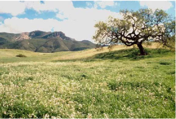
colonization in the 1700’s and early 1800’s, Franciscans established missions to claim the territory for Spain. Later, Spain granted tracts of land called “ranchos” to army veterans for raising cattle. In 1821, California became Mexican territory. Nine years later, Mexico divided the ranchos into smaller ranches. In 1891, Frederick and May Rindge purchased a large parcel of El Rancho Topanga Malibu Sequit. The family’s resistance to urban development in Malibu resulted in a legacy of open space in the Santa Monica Mountains (fig. 1).
The Santa Monica Mountains are dominantly steeply sloping mountain ranges with a few intervening flatter “valleys” and ocean terraces (fig. 2). Building site
development is dominantly in these flatter areas, although houses have been built on the steeper slopes in a few areas, such as on the mountains above the Malibu area. Considerable alteration of the soils has occurred in these areas. See the “Altered Soils” section for more detailed information.
In 1978, Congress established the Santa Monica Mountains National Recreation Area as part of the National park system. About 15 percent of the land in the recreation area is administered by the Federal government, about 22 percent is administered by the California Department of Parks and Recreation, and about 53 percent is privately owned. The major communities in the survey area are Malibu, Agoura, Calabasas, Monte Nido, Cornell, and Topanga.
Adjacent to the survey area are the major metropolitan areas of Los Angeles, the San Fernando Valley, and many cities such as Thousand Oaks and Ventura, with an approximate total population of 14 million, nearly 5 percent of the Nation’s total population. A large number of California State parks and beaches are within the survey area as well as many city and county parks and State and private conservancy land (fig. 3).
Currently, the Santa Monica Mountains National Recreation Area protects the greatest expanse of Mediterranean ecosystem in the National park system. It is generally considered the world’s largest “urban park,” because it is bounded by urban development.
Physiography, Relief, and Drainage
The Santa Monica Mountains National Recreation Area is in the southeast corner of Los Angeles County and the eastern part of Ventura County. The survey area is bounded on the east by the cities of Beverly Hills and Hollywood, on the north by Thousand Oaks, on the west by Camarillo and Oxnard, and on the south by the Pacific Ocean. The recreation area boundary on the south is at the high tide line along the Pacific Ocean. The area is about 46 miles long and 8 miles wide.
The dominant landforms in the survey area are steep, rugged mountains and hills, marine terraces, and intervening valleys. The area drains dominantly toward the Pacific Ocean. A narrow belt of marine terraces is along the ocean, extending west from Malibu to the Ventura County line. A few small valleys are throughout the area; Las Virgenes Canyon, La Jolla Valley, Seranno Valley, and Hidden Valley are the
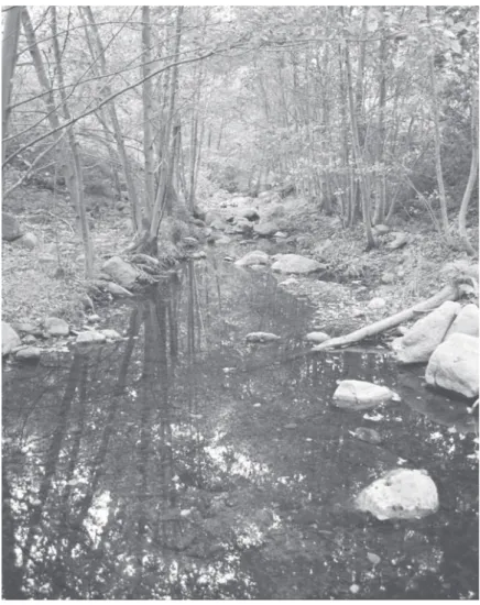
Figure 2.—View of Malibu Creek. Fluvaquents and Riverwash are on the creek bottom, and Sapwi soils are in areas of oak woodland.
largest ones. Elevation ranges from a few feet below sea level at the low tide mark in the tidal flats to 3,111 feet above sea level at Sandstone Peak. Other notable
mountains in the area are Laguna Peak, Castro Peak, Ladyface Mountain, Calabasas Peak, and Saddle Peak.
The recreation area can be divided into several geomorphic units. These include the steep, rugged mountains dissected by 49 coastal drainageways, the marine terraces along the ocean, the intervening valleys, and the coastal salt marshes of Mugu and Malibu Lagoons.
The steep, rugged mountains are part of the Transverse Range Geomorphic Province of California. Most of this land is open country because of the steepness of the terrain. The marine terraces along the Pacific Ocean are dissected by
drainageways originating in the adjacent hills and mountains. These terraces generally are used for building site development. Localized flooding can occur at the mouth of the drainageways during periods of high rainfall. The intervening valleys are used as building sites or for agriculture. The recreation area includes parts of the Calleguas Creek and Malibu Creek Watersheds. Several reservoirs are in the area, including Encino Reservoir, Stone Canyon Reservoir, Malibu Lake Reservoir, and Franklin Canyon Reservoir. Mugu Lagoon is part of the Mugu Naval Air Station and is a Federally protected wildlife habitat area.
Water Supply
Water supply varies from city to city. Most of the water comes from California water projects, such as the California Aqueduct in the north and the Colorado River and Owens Valley water projects in the south. In some areas the reservoir water is supplemented with ground water.
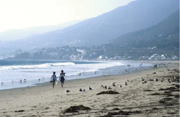
Figure 3.—View of the city of Malibu, along a coastal beach. The beaches are visited by millions of people each year.
Agriculture
Notable agriculture in the recreation area includes Broome and Thornhill Ranches, which manage cattle on the mountains at the west end of the area (fig. 4). Several ranches in Hidden Valley produce grass hay and raise horses. In Las Virgenes Canyon, the water district raises a small acreage of corn and has allowed sheep to graze the land after the harvest. Avocados and grapes are grown on hillsides in several small areas. Small areas scattered throughout the recreation area are used as nursery farms for ornamental and native plants.
Altered Soils
Areas of altered soils in the recreation area are dominantly those that have been subject to cut and fill operations in housing developments. These operations mix the existing soil material with crushed rock material, creating a very mixed soil that generally is classified as Xerorthents. The soils in cut areas can be shallow to bedrock, and those in fill areas are deeper.
Many of the “valleys” in the area historically have been under agriculture at some time. These areas now commonly have very clayey soils that do not have a surface layer, which is at least partly a result of incorporation of the surface layer into the subsoil during tillage operations. The areas probably once supported more native brush, but as a result of repeated burning by Indians and tillage by farmers, grass has become dominant. In some areas, the historical tillage lines can be seen on the adjacent hillsides above the “valley,” with grass within the tillage area and heavy brush outside of the tillage area. This probably occurs because the natural surface layer had
Figure 4.—View of Thornhill Ranch. Kayiwish soils are in the more gently sloping areas, and Cotharin soils are in the more steeply sloping areas.
considerably less clay than the underlying subsoil, and brush is not suited to the altered drainage and water holding capacity associated with the more clayey soils.
Some areas are artificially drained by the pumping of ground water, use of upstream diversions, and channeling of water. Some drainageways have altered drainage as a result of the deeply incised drainage channel. Sycamore Canyon is a good example.
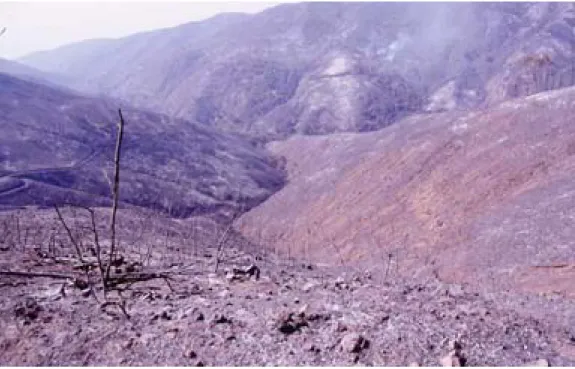
Fire History
All of the land in the Santa Monica Mountains National Recreation Area has burned at least once in the last 100 years. Some areas have burned as many as six times. Fanned by the high Santa Ana winds, fire reduces most native shrubs to charred stumps and ash. The dominant plant community in the mountains is
chaparral, which is particularly susceptible to fire because of its thick growth and high concentration of volatile oils. Fire is a natural process within the ecosystem of the mountains (fig. 5).
Soil Slippage
Landslides are evident throughout the recreation area. Some of the landslides have areas of deposition, but most do not because the deposited material has been washed away in the steep canyon bottoms, forming new beaches or filling in behind dams. The Rindge Dam is a good example. It is filled to the top with sediment.
The angle of repose is defined as the steepest angle that bare soil will maintain. For natural soils, the angle of repose is about 34 percent. In areas where the angle is higher, soil and rocks are totally under the influence of gravity and may slide downhill unless anchored by plants. All of the soils in the Santa Monica Mountains that have slopes of more than 34 percent are susceptible to soil slippage during dry periods.
Figure 5.—Area of Cotharin soils, showing the effects of the 1993 Green Meadows fire. This area presently is heavily revegetated with chaparral.
During periods of intense rainfall, the angle of repose decreases, depending on factors such as soil type and the amount of rainfall.
The underlying geology also influences the soil slippage potential. Soils that are particularly susceptible to slippage, or unstable, are those that are underlain by downslope-tilted sedimentary rock or by clay shale, those in areas of previous slides, and those that have parallel ridges underlain by basalt. The soils in this recreation area have been rated for their slippage potential. These ratings are given in table 19.
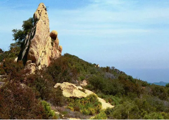
Areas that have flat-lying sedimentary rock are susceptible to slippage under certain conditions (moderately unstable). These areas are very rare in the
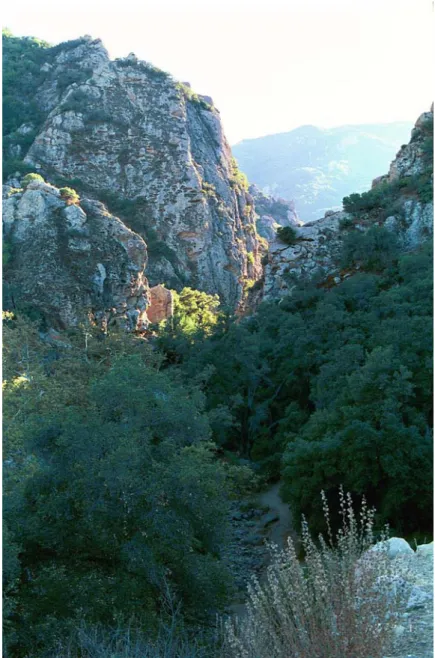
Santa Monica Mountains. Areas that have sedimentary beds that are perpendicular to the soil slope are much less susceptible to soil slippage. The protruding beds act as anchors or barriers to soil movement. The angle of geologic bedding can change greatly over short distances; therefore, onsite investigation is recommended (fig. 6).
Climate
Prepared by the Natural Resources Conservation Service, National Water and Climate Center, Portland, Oregon.
The climate tables were created from data gathered at the climate stations at Canoga Park, Pierce College; Santa Monica Pier; and University of California, Los Angeles (UCLA), in California. Additional information was obtained from several other precipitation-only climate stations in the region as well as from new official precipitation normals maps of California developed for the Natural Resources Conservation Service by Oregon State University using the PRISM modeling system (See “Glossary”).
Thunderstorm days, relative humidity, percent sunshine, and wind information were
estimated from data gathered at the First Order station at Los Angeles Civic Center, California.
Table 1 gives data on temperature and precipitation for the survey area as
recorded at Canoga Park, Pierce College; Santa Monica Pier; and UCLA in the period 1961 to 1990. Extremes reported are for the period 1949 to 1999. Table 2 shows probable dates of the first freeze in fall and the last freeze in spring as recorded at Canoga Park, Pierce College, in the period 1961 to 1990. Table 3 provides data on the length of the growing season as recorded at Canoga Park, Pierce College, in the period 1961 to 1990.
In winter, the average temperature is 54.6 degrees F at Canoga Park, Pierce College; 57.4 degrees at Santa Monica Pier; and 58.6 degrees at UCLA. The average daily minimum temperature in winter at these locations is 39.8 degrees,
50.0 degrees, and 50.6 degrees, respectively. The lowest temperatures on record are 18 degrees at Canoga Park, Pierce College, on February 6, 1989; 33 degrees at Santa Monica Pier on March 21, 1952; and 30 degrees at UCLA on January 4, 1949.
In summer, the average temperature is 74.6 degrees at Canoga Park, Pierce College; 64.9 degrees at Santa Monica Pier; and 68.0 degrees at UCLA. The average daily maximum temperature in summer at these locations is 92.8 degrees, 68.8 degrees, and 75.6 degrees, respectively. The highest temperatures on record are 116 degrees at Canoga Park, Pierce College, on August 24, 1985; 104 degrees at Santa Monica Pier on September 26, 1963; and 108 degrees at UCLA on
January 26, 1990. The inland region north of the coastal mountains is considerably warmer in the daytime during the warmest months than is the coastal strip.
Growing degree days are shown in table 1. They are equivalent to “heat units”. During the month, growing degree days accumulate by the amount that the average temperature each day exceeds a base temperature (50 degrees F). The normal monthly accumulation is used to schedule single or successive plantings of a crop between the last freeze in spring and the first freeze in fall.
At Santa Monica Pier and UCLA, temperatures near 32 degrees are extremely rare. The temperature has not been as low as 31 degrees at UCLA since 1957, and it has never been that low at Santa Monica Pier. In contrast, at Canoga Park, Pierce College, which is inland, frost is common in winter. The normal frost (32 degrees) season is from December 2 to March 4. At the higher elevations, frost is very uncommon, but temperatures near or slightly below 32 degrees occur every few years.
The average annual precipitation across the survey area is quite variable, depending largely on elevation and location. In general, the coastal strip receives 12 to 16 inches of precipitation per year. Precipitation increases inland, and the highest locations near Malibu receive about 30 inches of precipitation in an average year. Most of the rest of the coastal mountains receive 20 to 27 inches annually. Officially, the average annual precipitation is 16.33 inches at Canoga Park, Pierce College; 12.16 inches at Santa Monica Pier; and 16.25 inches at UCLA. At Lechuza Point climate station, which is at an elevation of 1,600 feet and is in the Zuna Ridge area of the western portion of the survey area, the average annual precipitation is about 21 inches. The heaviest 1-day rainfall on record is 6.57 inches at Canoga Park, Pierce College, on November 29, 1970; 5.11 inches at Santa Monica Pier on January 20, 1969; and 5.75 inches at UCLA, on January 26, 1956. Thunderstorms occur on average about 6 days each year, and they can occur in any month.
Snowfall is extremely rare in the survey area. At UCLA and Santa Monica Pier, there is no official record of measurable snowfall from the past 50 years. At Canoga Park, Pierce College, 0.5 inch of snow was recorded on February 8, 1989. At the Lechuza Point climate station, 6.2 inches of snow was recorded on January 12, 1949. In general, the highest mountain locations in the survey area receive a few inches of snow every decade or so. Snow is extremely uncommon elsewhere in the area.
The average relative humidity is highly dependent on location. In general, the highest humidity occurs along the ocean. In areas slightly inland, such as at the Los Angeles Civic Center, the average relative humidity in midafternoon is about 50 percent; the highest nighttime humidity is about 65 percent in winter and 85 percent in summer. The inland valleys north of the coastal hills are very dry, especially during the afternoon in summer, when the humidity typically drops to 20 to 30 percent or lower. Generally, the sun shines 80 to 90 percent of the time in summer throughout the survey area, except along the beach and in June. In winter, the sun shines approximately 70 percent of the time in all areas. The prevailing wind is highly dependent on location. At the Los Angeles Civic Center, the prevailing wind is from the west in all months except December and January, when it is from the northeast. The average windspeed is quite slow all year; it is highest, about 7 miles per hour, in February and March.
How This Survey Was Made
This survey was made to provide information about the soils and miscellaneous areas in the survey area. The information includes a description of the soils and miscellaneous areas and their location and a discussion of their suitability, limitations, and management for specified uses. Soil scientists observed the steepness, length, and shape of the slopes; the general pattern of drainage; the kinds of crops and native plants; and the kinds of bedrock. They dug many holes to study the soil profile, which is the sequence of natural layers, or horizons, in a soil. The profile extends from the surface down into the unconsolidated material in which the soil formed. The unconsolidated material is devoid of roots and other living organisms, except in fractures, and has not been changed by other biological activity.
The soils and miscellaneous areas in the survey area are in an orderly pattern that is related to the geology, landforms, relief, climate, and natural vegetation of the area. Each kind of soil and miscellaneous area is associated with a particular kind of landform or with a segment of the landform. By observing the soils and miscellaneous areas in the survey area and relating their position to specific segments of the
landform, a soil scientist develops a concept or model of how they were formed. Thus, during mapping, this model enables the soil scientist to predict with a considerable degree of accuracy the kind of soil or miscellaneous area at a specific location on the landscape.
Commonly, individual soils on the landscape merge into one another as their characteristics gradually change. To construct an accurate soil map, however, soil scientists must determine the boundaries between the soils. They can observe only a limited number of soil profiles. Nevertheless, these observations, supplemented by an understanding of the soil-vegetation-landscape relationship, are sufficient to verify predictions of the kinds of soil in an area and to determine the boundaries.
Soil scientists recorded the characteristics of the soil profiles that they studied. They noted soil color, texture, size and shape of soil aggregates, kind and amount of rock fragments, distribution of plant roots, reaction, and other features that enable them to identify soils. After describing the soils in the survey area and determining their properties, the soil scientists assigned the soils to taxonomic classes (units). Taxonomic classes are concepts. Each taxonomic class has a set of soil
characteristics with precisely defined limits. The classes are used as a basis for comparison to classify soils systematically. Soil taxonomy, the system of taxonomic classification used in the United States, is based mainly on the kind and character of soil properties and the arrangement of horizons within the profile. After the soil scientists classified and named the soils in the survey area, they compared the individual soils with similar soils in the same taxonomic class in other areas so that
they could confirm data and assemble additional data based on experience and research.
While a soil survey is in progress, samples of some of the soils in the area generally are collected for laboratory analyses and for engineering tests. Soil scientists interpret the data from these analyses and tests as well as the field-observed characteristics and the soil properties to determine the expected behavior of the soils under different uses. Interpretations for all of the soils are field tested through observation of the soils in different uses and under different levels of
management. Some interpretations are modified to fit local conditions, and some new interpretations are developed to meet local needs. Data are assembled from other sources, such as research information, production records, and field experience of specialists.
Predictions about soil behavior are based not only on soil properties but also on such variables as climate and biological activity. Soil conditions are predictable over long periods of time, but they are not predictable from year to year. For example, soil scientists can predict with a fairly high degree of accuracy that a given soil will have a high water table within certain depths in most years, but they cannot predict that a high water table will always be at a specific level in the soil on a specific date.
After soil scientists located and identified the significant natural bodies of soil in the survey area, they drew the boundaries of these bodies on aerial photographs and identified each as a specific map unit. Aerial photographs show trees, buildings, fields, roads, and rivers, all of which help in locating boundaries accurately.
The soils in this survey area were mapped at two levels of detail. At the more detailed level, map units are narrowly defined. Map unit boundaries were plotted and verified at closely spaced intervals. At the less detailed level, map units are broadly defined. Boundaries were plotted and verified at wider intervals. The areas in the survey area that have slopes of less than 9 percent were mapped at the more detailed level. These areas include La Jolla Valley, Serrano Valley, Hidden Valley, the city of Malibu, Cheeseboro Canyon, Paramount Ranch, Diamond X Ranch, Malibu Creek State Park, parts of the cities of Topanga and Calabasas, and other less notable areas. The remaining hills and mountains are mapped at the less detailed level.
Survey Procedures
The general procedures followed in making this survey are described in the “National Soil Survey Handbook” of the Natural Resources Conservation Service (Available in the State office of the Natural Resources Conservation Service at Davis, California, or online at http://soils.usda.gov/technical/handbook/) and the “Soil Survey Manual” (Soil Survey Division Staff, 1993).
Before the fieldwork began, preliminary boundaries of slopes and landforms were plotted stereoscopically on aerial photographs taken in 1984 and enlarged to a scale of 1:24,000. Soil scientists studied U.S. Geological Survey topographic maps to relate land and image features. A reconnaissance was made by vehicle before the
landscape was traversed on foot.
Sample areas that represent the major landscapes in the survey area were selected. These areas were investigated more closely than the rest of the survey area. Extensive notes were taken on the composition of map units in these preliminary study areas. As mapping progressed, these preliminary notes were modified and a final assessment of the composition of the individual map units was made.
As the traverses were made, the soil scientists divided the landscape into landforms or landform segments based on use and management of the soils. For
example, a hill was separated from a depression and a gently sloping summit from a very steep backslope of a ridge.
Observations of landforms, excavations and trenches, vegetation, roadcuts, and animal burrows were made without regard to spacing. Soil boundaries were
determined based on soil examinations and observations and on photointerpretation. The soil material was examined, with the aid of a hand auger or spade, to a depth of about 6 feet or to bedrock if within a depth of 6 feet. The typical pedons were
observed and studied in pits that were dug with shovels, spades, and backhoes. Samples for analyses of chemical and physical properties and of engineering properties were taken from representative sites of several of the soils in the survey area. The chemical and physical analyses were made by the National Soil Survey Laboratory, Natural Resources Conservation Service, Lincoln, Nebraska. The results of the analyses are stored in a computerized data file at the laboratory. A description of the laboratory procedures can be obtained on request from the laboratory. The results of the studies are available at the State office of the Natural Resources Conservation Service at Davis, California.
The general soil map with this publication shows broad areas that have a
distinctive pattern of soils, relief, and drainage. Each map unit on the general soil map is a unique natural landscape. Typically, it consists of one or more major soils or miscellaneous areas and some minor soils or miscellaneous areas. It is named for the major soils or miscellaneous areas, known as major components. The
components of one map unit can occur in another but in a different pattern. The general soil map can be used to compare the suitability of large areas for general land uses. Areas of suitable soils can be identified on the map. Likewise, areas where the soils are not suitable can be identified.
Because of its small scale, the map is not suitable for planning the management of a farm or field or for selecting a site for a road or building or other structure. The soils in any one map unit differ from place to place in slope, depth, drainage, and other characteristics that affect management.
1.
Sulfic Fluvaquents-Camarillo-Pacheco association,
0 to 2 percent slopes
Very deep, nearly level and level, somewhat poorly drained to very poorly drained soils that formed in mixed alluvium; on flood plains and tidal flats
Setting Landform: Flood plains and tidal flats
Slope: 0 to 2 percent
Composition Extent of map unit in survey area: Less than 1 percent Extent of components in map unit:
Sulfic Fluvaquents—43 percent Camarillo—34 percent
Pacheco—21 percent
Minor components—2 percent
Soil Properties and Qualities
Sulfic Fluvaquents Depth class: Very deep
Drainage class: Very poorly drained Position on landform: Tidal flats
Parent material: Alluvium derived from mixed sediment Slope: Level
Camarillo
Depth class: Very deep
Drainage class: Somewhat poorly drained Position on landform: Flood plains
Parent material: Alluvium derived from mixed sediment Slope: Nearly level
Pacheco
Depth class: Very deep
Drainage class: Poorly drained Position on landform: Flood plains
Parent material: Alluvium derived from mixed sediment Slope: Nearly level
Minor Components Haploxerolls
Major Uses Recreation and wildlife habitat
2.
Chumash-Malibu-Boades association, 30 to 75
percent slopes
Very shallow to moderately deep, steep and very steep, well drained and moderately well drained soils derived from shale and sandstone; on hills and mountains
Setting Landform: Hills and mountains
Slope: 30 to 75 percent
Composition Extent of map unit in survey area: About 14 percent Extent of components in map unit:
Chumash—33 percent Malibu—24 percent Boades—24 percent
Minor components—19 percent
Soil Properties and Qualities
Chumash
Depth class: Very shallow and shallow Drainage class: Well drained
Position on landform: Hills and mountains
Parent material: Residuum and colluvium derived from sandstone and shale Slope: Steep and very steep
Malibu
Depth class: Moderately deep
Drainage class: Moderately well drained Position on landform: Hills and mountains
Parent material: Residuum and colluvium derived from sandstone and shale Slope: Steep and very steep
Boades
Depth class: Shallow
Drainage class: Well drained
Parent material: Residuum and colluvium derived from sandstone and shale Slope: Steep and very steep
Minor Components
Cotharin soils, Pachic Argixerolls, Rock outcrop, Calcic Pachic Argixerolls, and Calcic Haploxerolls
Major Uses Recreation and housing development
3.
Cotharin-Talepop-Rock outcrop complex, 30 to 75
percent slopes
Shallow, steep and very steep, well drained soils that formed in igneous volcanic rock, and Rock outcrop; on hills and mountains
Setting Landform: Hills and mountains
Slope: 30 to 75 percent
Composition Extent of map unit in survey area: About 22 percent Extent of components in map unit:
Cotharin—69 percent Talepop—7 percent Rock outcrop—7 percent Minor components—17 percent
Soil Properties and Qualities
Cotharin
Depth class: Shallow
Drainage class: Well drained
Position on landform: Hills and mountains
Parent material: Residuum and colluvium derived from metavolcanic rock Slope: Steep and very steep
Talepop
Depth class: Shallow
Drainage class: Well drained
Position on landform: Hills and mountains
Parent material: Residuum and colluvium derived from metavolcanic rock Slope: Steep and very steep
Rock outcrop
Position on landform: Hills and mountains Parent material: Igneous volcanic rock Slope: Steep and very steep
Minor Components
Kayiwish soils, Typic Haploxerolls, Pachic Argixerolls, Lithic Haploxerolls, Cumulic Haploxerolls, Tongva soils, and Urban land
Major Uses Recreation and housing development
4.
Mipolomol-Topanga-Sapwi association, 30 to 75
percent slopes
Shallow and moderately deep, steep and very steep, well drained soils that formed in shale, sandstone, and slate; on hills and mountains
Setting Landform: Hills and mountains
Slope: 30 to 75 percent
Composition Extent of map unit in survey area: About 29 percent Extent of components in map unit:
Mipolomol—38 percent Topanga—38 percent Sapwi—8 percent
Minor components—16 percent
Soil Properties and Qualities
Mipolomol
Depth class: Shallow
Drainage class: Well drained
Position on landform: Hills and mountains
Parent material: Residuum and colluvium derived from sandstone and shale Slope: Steep and very steep
Topanga
Depth class: Shallow
Drainage class: Well drained
Position on landform: Hills and mountains
Parent material: Residuum and colluvium derived from sandstone and shale Slope: Steep and very steep
Sapwi
Depth class: Moderately deep Drainage class: Well drained
Position on landform: Hills and mountains
Parent material: Residuum and colluvium derived from sandstone Slope: Steep and very steep
Minor Components
Boades soils, Pachic Argixerolls, Typic Palexerolls, Rock outcrop, Typic Argixerolls, Kawenga soils, and Urban land
Major Uses Recreation and housing development
5.
Zumaridge-Rock outcrop-Kawenga association,
30 to 75 percent slopes
Shallow and deep, steep and very steep, well drained soils derived from sandstone, and Rock outcrop; on hills and mountains
Setting Landform: Hills and mountains
Slope: 30 to 75 percent
Composition Extent of map unit in survey area: About 10 percent Extent of components in map unit:
Zumaridge—28 percent Rock outcrop—24 percent Kawenga—10 percent
Minor components—38 percent
Soil Properties and Qualities
Zumaridge
Depth class: Shallow
Drainage class: Well drained
Position on landform: Hills and mountains
Parent material: Residuum and colluvium derived from sandstone Slope: Steep and very steep
Kawenga
Depth class: Deep
Drainage class: Well drained
Position on landform: Hills and mountains
Parent material: Residuum and colluvium derived from sandstone Slope: Steep and very steep
Rock outcrop
Position on landform: Hills and mountains Parent material: Sandstone and shale Slope: Steep and very steep
Minor Components
Sapwi soils, Typic Argixerolls, Typic Haploxerolls, Gaviota and Sumiwawa soils, Typic Xeropsamments, Hipuk soils, and Lithic Xerorthents
Major Uses Recreation and housing development
6.
Linne-Gaviota-Los Osos complex, 30 to 75 percent
slopes
Very shallow and moderately deep, well drained soils derived from marine shale and sandstone; on hills and mountains
Setting Landform: Hills and mountains
Slope: 30 to 75 percent
Composition Extent of map unit in survey area: About 9 percent Extent of components in map unit:
Linne—31 percent Gaviota—22 percent Los Osos—14 percent
Minor components—33 percent
Soil Properties and Qualities
Linne
Depth class: Moderately deep Drainage class: Well drained Position on landform: Hills
Parent material: Residuum derived from marine shale Slope: Steep and very steep
Gaviota
Depth class: Very shallow Drainage class: Well drained
Position on landform: Hills and mountains
Parent material: Residuum and colluvium derived from sandstone Slope: Steep and very steep
Los Osos
Depth class: Moderately deep Drainage class: Well drained Position on landform: Hills
Parent material: Residuum and colluvium derived from marine shale and sandstone Slope: Steep and very steep
Minor Components
Sapwi and Elder soils, Rock outcrop, Calcic Haploxerolls, Mollic Haploxerolls, Cropley soils, Xerorthents, Haploxerepts, Typic Argixerolls, and Pachic Argixerolls
Major Uses Recreation and housing development
7.
Botella-Cropley-Urban land complex, 0 to 9 percent
slopes
Very deep, nearly level to moderately sloping, well drained soils that formed in sedimentary material, and Urban land; on alluvial fans and hills
Setting Landform: Hills and alluvial fans
Slope: 0 to 30 percent
Composition Extent of map unit in survey area: About 4 percent Extent of components in map unit:
Botella—20 percent Cropley—18 percent Urban land—15 percent
Minor components—47 percent
Soil Properties and Qualities
Botella
Depth class: Very deep Drainage class: Well drained Position on landform: Alluvial fans
Parent material: Alluvium derived from sedimentary rock Slope: Gently sloping
Cropley
Depth class: Very deep Drainage class: Well drained Position on landform: Alluvial fans
Parent material: Residuum and colluvium derived from sedimentary rock Slope: Nearly level to moderately sloping
Urban land
Position on landform: Hills and alluvial fans Slope: Nearly level
Minor Components
Danville and Abaft soils, Typic Xeropsamments, Beaches, Riverwash, Typic Xerorthents, Elder soils, Pachic Argixerolls, Lockwood soils, and Cumulic Haploxerolls
Major Uses Recreation and housing development
8.
Balcom-Xerorthents, landscaped-Urban land complex,
0 to 75 percent slopes
Shallow to very deep, nearly level to very steep, well drained soils derived from shale and sandstone; on hills
Setting Landform: Hills
Slope: 0 to 75 percent
Composition Extent of map unit in survey area: About 3 percent Extent of components in map unit:
Balcom—50 percent
Xerorthents, landscaped—20 percent Urban land—18 percent
Minor components—12 percent
Soil Properties and Qualities
Balcom
Depth class: Moderately deep Drainage class: Well drained Position on landform: Hills
Parent material: Residuum derived from shale and sandstone Slope: Steep and very steep
Xerorthents, landscaped Depth class: Shallow to deep Drainage class: Well drained Position on landform: Hills
Parent material: Residuum derived from marine shale and sandstone Slope: Nearly level to moderately steep
Urban land
Position on landform: Hills
Description of areas: Houses and other buildings, streets, parking lots, and association landscaped areas
Slope: Nearly level to moderately steep
Minor Components
Urban land, Typic Xerochrepts, Botella soils, Typic Calcixerolls, Xerorthents, Rock outcrop, and Pachic Argixerolls
Major Uses Recreation and housing development
9.
Cumulic Haploxerolls-Elder-Fluvaquents complex,
0 to 9 percent slopes
Very deep, nearly level to gently rolling, well drained and very poorly drained soils that formed in alluvium derived from volcanic and sedimentary material; in
drainageways
Setting Landform: Inset fans and flood plains
Slope: 0 to 9 percent
Composition Extent of map unit in survey area: About 1 percent Extent of components in map unit:
Cumulic Haploxerolls—58 percent Elder—17 percent
Fluvaquents—9 percent
Minor components—16 percent
Soil Properties and Qualities
Cumulic Haploxerolls Depth class: Very deep Drainage class: Well drained Position on landform: Inset fans
Parent material: Alluvium derived from volcanic and sedimentary material Slope: Nearly level to gently rolling
Elder
Depth class: Very deep Drainage class: Well drained Position on landform: Flood plains
Parent material: Alluvium derived from shale and sandstone Slope: Nearly level
Fluvaquents
Depth class: Very deep
Drainage class: Very poorly drained Position on landform: Flood plains
Parent material: Alluvium derived from volcanic and sedimentary material Slope: Nearly level
Minor Components Riverwash, Danville soils, Typic Argixerolls, and Botella soils
Major Uses Recreation and housing development
10.
Urban land-Xerorthents, landscaped complex, 0 to 9
percent slopes
Urban land, and shallow to very deep, level to moderately sloping, well drained soils derived from sedimentary rock; on hills, mountains, valleys, and alluvial fans
Setting Landform: Hills, mountains, valleys, and alluvial fans Slope: 0 to 9 percent
Composition Extent of map unit in survey area: About 8 percent Extent of components in map unit:
Urban land—69 percent
Xerorthents, landscaped—29 percent Minor components—2 percent
Soil Properties and Qualities
Urban land
Position on landform: Hills and mountains
Description of areas: Houses and other buildings, streets, parking lots, and association landscaped areas
Slope: Level to moderately sloping Xerorthents, landscaped
Depth class: Shallow to very deep Drainage class: Well drained
Position on landform: Hills, mountains, valleys, and alluvial fans
Parent material: Residuum and colluvium derived from sedimentary rock Slope: Level to moderately sloping
Minor Components Elder soils
Major Uses
The map units delineated on the detailed soil maps in this survey represent the soils or miscellaneous areas in the survey area. The map unit descriptions in this section, along with the maps, can be used to determine the suitability and potential of a unit for specific uses. They also can be used to plan the management needed for those uses. More information about each map unit is given under the heading “Use and Management of the Soils.”
A map unit delineation on a soil map represents an area dominated by one or more major kinds of soil or miscellaneous areas. A map unit is identified and named according to the taxonomic classification of the dominant soils. Within a taxonomic class there are precisely defined limits for the properties of the soils. On the landscape, however, the soils are natural phenomena, and they have the
characteristic variability of all natural phenomena. Thus, the range of some observed properties may extend beyond the limits defined for a taxonomic class. Areas of soils of a single taxonomic class rarely, if ever, can be mapped without including areas of other taxonomic classes. Consequently, every map unit is made up of the soils or miscellaneous areas for which it is named and some minor components that belong to taxonomic classes other than those of the major soils.
Most minor soils have properties similar to those of the dominant soil or soils in the map unit, and thus they do not affect use and management. These are called
noncontrasting, or similar, components. They may or may not be mentioned in a particular map unit description. Other minor components, however, have properties and behavioral characteristics divergent enough to affect use or to require different management. These are called contrasting, or dissimilar, components. They generally are in small areas and could not be mapped separately because of the scale used. The contrasting components are mentioned in the map unit descriptions. A few areas of minor components may not have been observed, and consequently they are not mentioned in the descriptions, especially where the pattern was so complex that it was impractical to make enough observations to identify all the soils and
miscellaneous areas on the landscape.
The presence of minor components in a map unit in no way diminishes the usefulness or accuracy of the data. The objective of mapping is not to delineate pure taxonomic classes but rather to separate the landscape into landforms or landform segments that have similar use and management requirements. The delineation of such segments on the map provides sufficient information for the development of resource plans. If intensive use of small areas is planned, however, onsite investigation is needed to define and locate the soils and miscellaneous areas.
An identifying symbol precedes the map unit name in the map unit descriptions. Each description includes general facts about the unit and gives the principal hazards and limitations to be considered in planning for specific uses.
Soils that have profiles that are almost alike make up a soil series. Except for differences in texture of the surface layer, all the soils of a series have major horizons that are similar in composition, thickness, and arrangement.
Soils of one series can differ in texture of the surface layer, slope, stoniness, salinity, degree of erosion, and other characteristics that affect their use. On the basis of such differences, a soil series is divided into soil phases. Most of the areas shown
on the detailed soil maps are phases of soil series. The name of a soil phase
commonly indicates a feature that affects use or management. For example, Cropley clay, 0 to 2 percent slopes, is a phase of the Cropley series.
Some map units are made up of two or more major soils or miscellaneous areas. These map units are complexes or associations.
A complex consists of two or more soils or miscellaneous areas in such an intricate pattern or in such small areas that they cannot be shown separately on the maps. The pattern and proportion of the soils or miscellaneous areas are somewhat similar in all areas. Danville-Urban land complex, 0 to 9 percent slopes, is an example.
An association is made up of two or more geographically associated soils or miscellaneous areas that are shown as one unit on the maps. Because of present or anticipated uses of the map units in the survey area, it was not considered practical or necessary to map the soils or miscellaneous areas separately. The pattern and relative proportion of the soils or miscellaneous areas are somewhat similar. Chumash-Boades-Malibu association, 30 to 75 percent slopes, is an example.
This survey includes miscellaneous areas. Such areas have little or no soil material and support little or no vegetation. Rock outcrop is an example.
Table 4 gives the acreage and proportionate extent of each map unit. Other tables give properties of the soils and the limitations, capabilities, and potentials for many uses. The Glossary defines many of the terms used in describing the soils or miscellaneous areas.
100—Chumash-Boades-Malibu association, 30 to 75
percent slopes
Map Unit Setting General location: Low-elevation coastal hills and mountains
Major uses: Wildlife habitat, recreation, and building site development Major land resource area (MLRA): 20—Southern California Mountains Landform: Hills and mountains
Elevation: 5 to 1,545 feet (3 to 471 meters)
Mean annual precipitation: 14 to 18 inches (360 to 457 millimeters) Mean annual air temperature: 60 to 64 degrees F (16 to 18 degrees C) Frost-free period: 290 to 350 days
Map Unit Composition Chumash and similar soils—35 percent
Boades and similar soils—25 percent Malibu and similar soils—25 percent Minor components—15 percent
Major Components
Chumash Slope: 30 to 75 percent
Aspect (clockwise): Dominantly southwest to southeast Landform: Hills and mountains
Parent material: Colluvium and/or residuum derived from sandstone and shale Typical vegetation: Grey coast eriogonum
Selected properties and qualities Surface pH: 6.8
Surface area covered with coarse fragments: None
Slowest permeability class: Moderate above the bedrock Salinity: Nonsaline
Sodicity: Nonsodic
Available water capacity to a depth of 60 inches: About 0.9 inch (very low) Shrink-swell potential: Moderate (LEP 3 to less than 6)
Soil slippage potential: High Selected hydrologic properties Present annual flooding: None Present annual ponding: None Surface runoff: Very high Current water table: Not present
Natural drainage class: Somewhat excessively drained Hydrologic soil group: D
California land use interpretive groups Land capability class (irrigated): Not calculated Land capability class (nonirrigated): 7e
Farmland classification: Not prime farmland or statewide important farmland Ecological site: R020XD041CA, Shallow Coastal Scrub 14-16" p.z.
Typical profile
A—0 to 7 inches; gravelly loam
Cr—7 to 17 inches; soft, weathered bedrock Boades Slope: 30 to 75 percent
Aspect (clockwise): Dominantly northwest to northeast Landform: Hills and mountains
Parent material: Colluvium and/or residuum derived from sandstone and shale
Typical vegetation: Coastal scrub Selected properties and qualities Surface pH: 6.0
Surface area covered with coarse fragments: None
Depth to restrictive feature: Bedrock (paralithic)—10 to 20 inches Slowest permeability class: Moderately slow above the bedrock Salinity: Nonsaline
Sodicity: Nonsodic
Available water capacity to a depth of 60 inches: About 1.6 inches (very low) Shrink-swell potential: Moderate (LEP 3 to less than 6)
Soil slippage potential: High Selected hydrologic properties Present annual flooding: None Present annual ponding: None Surface runoff: Very high Current water table: Not present Natural drainage class: Well drained Hydrologic soil group: D
California land use interpretive groups Land capability class (irrigated): Not calculated Land capability class (nonirrigated): 7e
Farmland classification: Not prime farmland or statewide important farmland Ecological site: R020XD039CA, Coastal Scrub 14-16" p.z.
Typical profile
A1—0 to 2 inches; loam A2—2 to 14 inches; loam
Cr—14 to 24 inches; soft, weathered bedrock Malibu Slope: 30 to 75 percent
Aspect (clockwise): Dominantly northeast to west Landform: Hills and mountains
Parent material: Colluvium and/or residuum derived from interbedded sandstone and shale
Typical vegetation: Coastal scrub Selected properties and qualities Surface pH: 6.4
Surface area covered with coarse fragments: None
Depth to restrictive feature: Bedrock (paralithic)—20 to 40 inches Slowest permeability class: Very slow above the bedrock
Salinity: Nonsaline Sodicity: Nonsodic
Available water capacity to a depth of 60 inches: About 3.4 inches (low) Shrink-swell potential: Moderate (LEP 3 to less than 6)
Soil slippage potential: High Selected hydrologic properties Present annual flooding: None Present annual ponding: None Surface runoff: Very high Current water table: Not present
Natural drainage class: Moderately well drained Hydrologic soil group: D
California land use interpretive groups Land capability class (irrigated): Not calculated Land capability class (nonirrigated): 7e
Farmland classification: Not prime farmland or statewide important farmland Ecological site: R020XD039CA, Coastal Scrub 14-16" p.z.
Typical profile
A—0 to 19 inches; loam 2Bt—19 to 27 inches; clay
2Cr—27 to 37 inches; weathered bedrock
Minor Components
Pachic Argixerolls
Percentage of map unit: About 5 percent Slope: 15 to 50 percent
Landform: Hills and mountains Rock outcrop
Percentage of map unit: About 5 percent Landform: Hills and mountains
Cotharin
Percentage of map unit: About 5 percent Slope: 30 to 75 percent
101—Chumash-Boades-Malibu association, 5 to 15
percent slopes
Map Unit Setting General location: Low-elevation coastal hills and mountains
Major uses: Wildlife habitat, recreation, and building site development Major land resource area (MLRA): 20—Southern California Mountains Landform: Hills and mountains
Elevation: 150 to 895 feet (46 to 274 meters)
Mean annual precipitation: 14 to 18 inches (360 to 457 millimeters) Mean annual air temperature: 60 to 64 degrees F (16 to 18 degrees C) Frost-free period: 290 to 350 days
Map Unit Composition Chumash and similar soils—35 percent
Boades and similar soils—25 percent Malibu and similar soils—25 percent Minor components—15 percent
Major Components
Chumash Slope: 5 to 15 percent
Aspect (clockwise): Dominantly northeast to south Landform: Hills and mountains
Parent material: Colluvium and/or residuum derived from sandstone and shale Typical vegetation: Grey coast eriogonum
Selected properties and qualities Surface pH: 6.8
Surface area covered with coarse fragments: None
Depth to restrictive feature: Bedrock (paralithic)—4 to 22 inches Slowest permeability class: Moderate above the bedrock Salinity: Nonsaline
Sodicity: Nonsodic
Available water capacity to a depth of 60 inches: About 1 inch (very low) Shrink-swell potential: Moderate (LEP 3 to less than 6)
Soil slippage potential: High Selected hydrologic properties Present annual flooding: None Present annual ponding: None Surface runoff: Very high Current water table: Not present
Natural drainage class: Somewhat excessively drained Hydrologic soil group: D
California land use interpretive groups Land capability class (irrigated): Not calculated Land capability class (nonirrigated): 7e
Farmland classification: Not prime farmland or statewide important farmland Ecological site: R020XD041CA, Shallow Coastal Scrub 14-16" p.z.
Typical profile
A—0 to 9 inches; gravelly loam
Boades Slope: 5 to 15 percent
Aspect (clockwise): Dominantly northeast to south Landform: Hills and mountains
Parent material: Colluvium and/or residuum derived from sandstone and shale Typical vegetation: Coastal scrub
Selected properties and qualities Surface pH: 6.0
Surface area covered with coarse fragments: None
Depth to restrictive feature: Bedrock (paralithic)—10 to 20 inches Slowest permeability class: Moderately slow above the bedrock Salinity: Nonsaline
Sodicity: Nonsodic
Available water capacity to a depth of 60 inches: About 1.6 inches (very low) Shrink-swell potential: Moderate (LEP 3 to less than 6)
Soil slippage potential: High Selected hydrologic properties Present annual flooding: None Present annual ponding: None Surface runoff: Very high Current water table: Not present Natural drainage class: Well drained Hydrologic soil group: D
California land use interpretive groups Land capability class (irrigated): Not calculated Land capability class (nonirrigated): 7e
Farmland classification: Not prime farmland or statewide important farmland Ecological site: R020XD039CA, Coastal Scrub 14-16" p.z.
Typical profile
A1—0 to 2 inches; loam A2—2 to 14 inches; loam
Cr—14 to 24 inches; soft, weathered bedrock Malibu Slope: 5 to 15 percent
Aspect (clockwise): Dominantly northeast to south Landform: Hills and mountains
Parent material: Colluvium and/or residuum derived from interbedded sandstone and shale
Typical vegetation: Coastal scrub Selected properties and qualities Surface pH: 6.4
Surface area covered with coarse fragments: None
Depth to restrictive feature: Bedrock (paralithic)—20 to 40 inches Slowest permeability class: Very slow above the bedrock
Salinity: Nonsaline Sodicity: Nonsodic
Available water capacity to a depth of 60 inches: About 3.4 inches (low) Shrink-swell potential: Moderate (LEP 3 to less than 6)