Reporting of road traffic accidents in London:
Matching police STATS19 with hospital accident and
emergency department data.
Supplementary Report for St. Thomas’ Hospital
Central London.
by Heather Ward, Sandy Robertson (UCL)
Katherine Townley and Annette Pedler (TRL Limited)
UPR T/043/05
Clients Project Reference Number
UNPUBLISHED PROJECT REPORT
UNPUBLISHED PROJECT REPORT UPR T/043/05
REPORTING OF ROAD TRAFFIC ACCIDENTS IN LONDON:
MATCHING POLICE STATS19 WITH HOSPITAL ACCIDENT AND
EMERGENCY DEPARTMENT DATA.
SUPPLEMENTARY REPORT FOR ST. THOMAS’ HOSPITAL
CENTRAL LONDON.
Version: Phase 3 Final
by Heather Ward, Sandy Robertson (UCL), Katherine Townley and Annette Pedler (TRL Limited)
Project Record: Reporting Levels of Road Traffic Accidents
Client: Street Management, Transport for London,
(Nina Webster)
Copyright TRL Limited May 2005
This report, prepared for Transport for London (Street Management) is unpublished and should not be referred to in any other document or publication without the permission of Transport for London. The views expressed are those of the author(s) and not necessarily those of the client.
Approvals Project Manager
TRL is committed to optimising energy efficiency, reducing waste and promoting recycling and re-use. In support of these environmental goals, this report has been printed on recycled paper, comprising 100% post-consumer waste, manufactured using a TCF (totally chlorine free) process.
CONTENTS
Executive summary 1
1 Introduction 3
1.1 Definition of reporting rate 3
2 Definition of the St Thomas’ hospital area 6
3. Method 9
4. Results 10
4.1 The overall picture 10
4.2 Detailed breakdown of results for St. Thomas’ Hospital 14
4.2.1 Hospital data for inside the area only 14
4.2.2 Lower estimates of reporting rate using All hospital data for inside and
cross border casualties 16
4.2.3 Best estimates of reporting rates using Hospital data for inside and
estimated unmatched cross border casualties 18
5. Interpretation of results 20
6. Other issues 22
7. Acknowledgements 22
8. References 25
Appendix 1: The data-matching process 26
A1.1 Sorting hospital records according to location in or outside the cordon 26 A1.1.1 Procedure for estimating casualties on roads running through the area and out the
other side? 26
A1.1.2 Hospital data whose location was unknown. 27
A1.2 The matching process 27
A1.2.1 The combined dataset 27
A1.2.2 Data coding 28
A1.3 The matching algorithm 29
A1.4 Automated matching 30
A1.5 Manual matching 30
Executive summary
A previous study for Transport for London (TfL) had taken three hospitals in London and matched their road traffic casualty data with the STATS19 police records for the same areas. The hospitals were St Mary’s Paddington, representing Central London, King’s College Hospital Camberwell, representing Inner London, and Barnet General Hospital, representing Outer London. The results indicate that the percentage of road traffic casualties known to the police in London through the STATS19 data collection process is higher than found by other studies elsewhere in the country (see for example Simpson 1996, Ward et al 1994, Robertson and Ward 2002)) with the King’s area being about 71 percent, Barnet about 70 percent and St Mary’s about 87 percent. This latter figure was considered to be high even for London so a second Central London hospital, St Thomas’ was chosen in order to estimate the reporting rate in this area which forms the basis of this study.
Using the same methodology and time period (2001) as in the first study it was estimated that the reporting rate for St Thomas’ was about 79 percent. This is considerably higher than Barnet and King’s but lower than St Mary’s.
The table on the following page combines results from both studies and shows estimates of the headline percentage reporting rates to the police for the four hospital areas.
The indications are that there is a Central London effect which increases the reporting rate. Two possible explanations for this are:
• If a casualty feels well enough to continue home and once there they feel the need for treatment, they will go to the local hospital near where they live and not back to the Central London Hospital near where they were injured. Therefore, for this unquantified group of people, their injury may be in the police record for the study area and in the record of some other hospital unknown to us but not the hospital record being studied. This would have the effect of increasing the proportion of casualties known to the police relative to the number of all known casualties and thus increase the estimated reporting rate.
• The level of police presence and awareness of traffic incidents in Central London means that when a road traffic accident occurs the police are on the scene very quickly, thus making it more likely that the accident will be reported and appear in the STATS19 record.
Based on the proportion of road traffic accident casualties to all A&E attendances at the four hospitals studied, it was concluded that the St Mary’s Hospital record for road traffic accident casualties was about half what might be expected based on its total number of A&E
attendances. This suggests that the dataset used in the original study may not have been complete, leading to a higher than average estimated reporting rate.
The total number of road traffic casualties attending the 33 London hospitals with full time A&E departments was estimated to be about 44 700 people, there were 44 500 casualties reported to the police. The total number of road traffic casualties in London in 2001 is therefore estimated to be about 68 500.
Rate=All casualties known to police/All known casualties.
Casualty class Area in
London Lower estimate 1 Upper estimate2 Current best estimate3 All casualties Kings Inner 66 80 71 Barnet Outer 61 75 70 St Mary’s Central 77 91 87 St Thomas’ Central 71 84 79 Pedestrian casualties Kings Inner 62 78 67 Barnet Outer 72 78 70 St Mary’s Central 66 84 78 St Thomas’ Central 69 82 78
Pedal cyclist casualties
Kings Inner 61 75 66
Barnet Outer 60 75 69
St Mary’s Central 89 98 96
St Thomas’ Central N/A N/A N/A
TWMV casualties
Kings Inner 74 87 78
Barnet Outer 65 80 73
St Mary’s Central 74 92 85
St Thomas’ Central N/A N/A N/A
Car occupant casualties
Kings Inner 67 78 72
Barnet Outer 58 73 68
St Mary’s Central 82 92 90
St Thomas’ Central 71 84 79
1 This estimate includes all casualties identified as being in the area only for police data and all those that are in the area and on cross border roads for the hospital
2 This estimate includes all casualties identified as being in the area only for hospital and police data 3
This estimate includes all casualties identified as being in the area only for police data and all those that are in the area plus adjusted number for those on cross border roads for the hospital
1
Introduction
During 2002, Transport for London (TfL) commissioned work to estimate the level of reporting to the police of road accident casualties in London in order to:
• Provide a base-line against which the effect of policy initiatives can be properly assessed, given that the level of reporting might be influenced and change over time. Such
initiatives might include publicity campaigns, road safety engineering programmes, and congestion charging.
• Improve understanding of the extent of the accident and casualty problem.
• Provide robust information on the reporting of the severity of injuries, and
• Engender better working relationships and cooperation with Health Authorities and Hospitals.
In the original project records were used from Accident and Emergency (A&E) Departments of three representative hospitals (outer, inner and central London) to supplement those of the police to allow us to estimate of the proportion of people injured who report their injury accident to the police. From these two sets of records estimates can be made of the reporting rate to the police, and at the same time improve the estimate of the level of injury in London.
1.1 Definition of reporting rate
The reporting rate used in this study can be described as all casualties known to the police divided by all known casualties. Electronic records were requested from three London hospitals, out of a total of 31 hospitals with full time A&E Departments. They were chosen to represent Central (St Mary’s Hospital, Paddington), Inner (Kings College Hospital,
Camberwell) and Outer London (Barnet General Hospital, Barnet).
The method of calculation of reporting rate may vary between different studies. Here the reporting rate to the police is calculated as follows:-
(p+b)/(p+h+b) Where:
p= number of casualties reported to the police only;
b= number of casualties reported to both police and hospital; h= number of casualties reported to the hospital only.
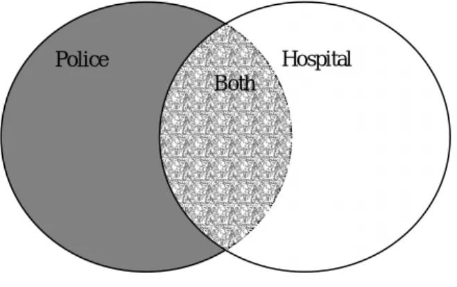
Figure 1. The overlap between police and hospital casualty records Police Hospital
In other words all casualties known to the police divided by all known casualties. This is shown schematically in Figure 1. The reporting rate is the shaded areas divided by the total area.
Table 1 shows estimates of the headline reporting rates to the police for each hospital area in the original study. It can be seen that the values for St. Mary’s Hospital, representing Central London, are higher than for King’s College Hospital, representing Inner London, and Barnet General Hospital, representing Outer London. There was some concern that there may have been a shortfall in the number of casualties reported as road traffic accidents (RTAs) at St. Mary’s and a subsequent overestimation of the reporting rate.
Table 1: Estimates of the headline reporting rates to the police for the three hospital areas in the original study.
Rate=All casualties known to police/All known casualties.
Casualty class Area in
London Lower estimate 1 Upper estimate2 Current best estimate3 All casualties Kings Inner 66 80 71 Barnet Outer 61 75 70 St Mary’s Central 77 91 87 Pedestrian casualties Kings Inner 62 78 67 Barnet Outer 72 78 70 St Mary’s Central 66 84 78
Pedal cyclist casualties
Kings Inner 61 75 66 Barnet Outer 60 75 69 St Mary’s Central 89 98 96 TWMV casualties Kings Inner 74 87 78 Barnet Outer 65 80 73 St Mary’s Central 74 92 85
Car occupant casualties
Kings Inner 67 78 72
Barnet Outer 58 73 68
St Mary’s Central 82 92 90
To investigate this, and other possibilities, it was decided to study St. Thomas’ or University College London (UCL) Hospitals as central London hospitals and calculate their reporting
1 This estimate includes all casualties identified as being in the area only for police data and all those that are in the area and on cross border roads for the hospital
2 This estimate includes all casualties identified as being in the area only for hospital and police data 3
This estimate includes all casualties identified as being in the area only for police data and all those that are in the area plus adjusted number for those on cross border roads for the hospital
rates. In the event, the UCL Hospital data was not suitable as it did not include location data so St Thomas’ provided a dataset for 2001 (the same year as in the original study).
This supplementary report documents the analysis and findings using this supplementary data.
2
Definition of the St Thomas’ hospital area
There are no definitive catchment areas for London hospitals. In the same way that areas for study around the other three hospitals were selected, London Ambulance Service Data was used as a guide to what was an appropriate area within which casualty records could be identified for linking and matching. The definition of this area aimed to maximise the
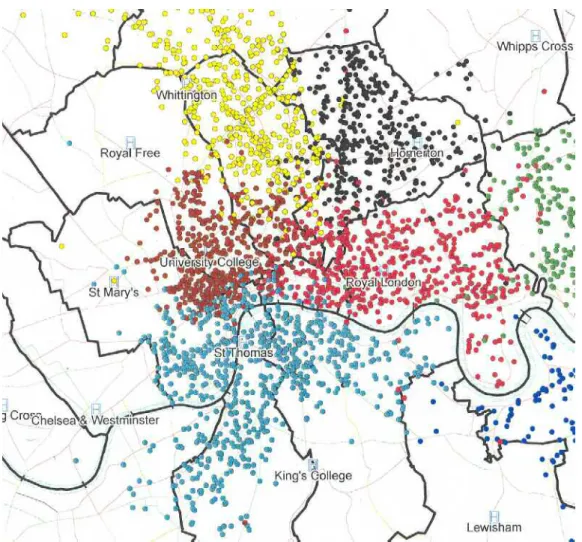
proportion of casualties within it that were taken to St Thomas’ hospital rather than any other. Figure 2 shows the London Ambulance Service data on the locations of casualties taken to St Thomas’ Hospital in 2001. Figure 3 shows the boundary of the area selected for study and the location of Police Stats19 records within that area.
The boundaries agreed between UCL and TfL for St Thomas’ Hospital are shown in Figure 2. The approximate area bounded by each cordon is as follows:
St. Mary's Hospital 7.9 km sq King’s College Hospital 16.2 km sq Barnet General Hospital 44.3 km sq St. Thomas’ Hospital 10.2 km sq
By comparison with the other areas, the St Thomas’ area chosen for study is compact compared with King’s and Barnet but is slightly larger than St. Mary’s.
Figure 2: London Ambulance Data indicating the Location of Casualties taken to St Thomas’ and four other hospitals in London
Source InfoMap
Figure 3: Location of Police Stats19 Records within the boundary (shown by the green line) of the area selected for study.
Table 2 shows the total number of casualties in the A&E datasets for St. Thomas’ compared with the other three hospitals and Table 3 shows the number of casualties in the STATS19 record for each area defined by the cordon. Whilst the area within the cordon for St Thomas’ is relatively small, the number of STATS19 casualties is some 45-50 percent higher than for St Mary’s or King’s. The number of casualties in the hospital record is some three times higher than in the total St Mary’s record and 1.5 times higher than in the King’s record. It should be noted that these totals in Table 2 are for the whole of the A&E set and not only for those inside the cordon.
Table 2: Number of casualties in hospital datasets for 2001 Barnet St
Mary's
King’s St.Thomas’
Table 3: Number of Police STATS19 casualty records for each hospital area. Barnet St. Mary’s King’s College St Thomas’
3. Method
Unlike the STATS19 data which includes 10 digit grid references for the location of every accident, the hospital data only records a road name, e.g. Oxford Street, Marylebone Road, Edgware Road. Whereas an area can be defined using a grid-referenced polygon for the police data this cannot be done for the hospital data. Also there is no absolute boundary for each hospital where a person might be expected to be taken by ambulance, or go to on their own, in the event of an injury.
For the St Thomas’ area the hospital data needed to be sorted to ascertain whether or not each record lay within a cordon drawn around the hospital to create an area within which casualty records could be identified for linkage and matching (see Section 2). The procedure is described in Appendix 1.
The following datasets were matched with the STATS19 data as described in Section 3 of the original report and reproduced in Appendix 1
1. Hospital data for inside the area only.
2. All hospital data for inside and cross border casualties
3. Hospital data for inside and adjusted unmatched cross border casualties
This resulted in three estimates of the reporting rate. The first, using hospital data for inside the area only will give the highest reporting rate and is obviously an overestimation because only a proportion of the ‘true’ hospital dataset is being used. The second set of tables gives us the lowest reporting rate and is an underestimation because all the hospital data that lies on boundary roads is included and in the ‘true’ dataset only some of these will be in the area. The best estimate of reporting rate lies between these two figures. Using the adjustment described in Section 2 of the original report and Appendix 1, the reader is guided to where this reporting rate might lie within the range. More work needs to be done to refine this process and an opportunity arises under work commissioned by the Department for Transport using data from other areas of England. Until this is completed the estimate is still considered to be the best estimate.
4.
Results
4.1 The overall picture
The St Thomas’ 2001 data did not accurately distinguish between pedal cycle casualties and two-wheeled motor vehicle casualties (TWMV). Table 4 shows how the matched records were categorised by the police and by the hospital.
In Table 4 the data shows all the police data and hospital data that were matched to the police records. Unmatched hospital data is also included for completeness. The rows represent the categorisation of casualty class recorded by the police and the columns represent the casualty class as identified by the hospital. Police data for casualty class is currently thought to be more accurate than hospital data for casualty class on the basis of the police presence at the scene of the accident. Police data is therefore used for defining class of user when it is available (i.e. for all casualties know to the police). Where there are inconsistencies between the police and hospital categorisations of road user class, these will affect casualties known to the police and casualties known only to the hospital and hence the estimate of reporting rate. Additionally the proportion of casualties in each classes is different for those known to the police and known only to the hospital for example
The largest inconsistencies for matched casualties is for the casualties identified as being TWMVs by the police. Of the 141 matched records shown in Table 4, (matched on other factors such as date, time, age and gender) 80 were categorised by the hospital as pedal cycles, 51 as other and 10 as car/van/bus. We there fore do not know how many TWMV casualties went to St Thomas’s hospital as a result of their injuries. By extension, we do not know how many pedal cyclists attended hospital because of their injuries because about half of those in the hospital record are probably TWMVs.
Owing to the inconsistency of categorisation it is not possible to obtain estimates of reporting rates for PC, ‘other’ or TWMV that would be comparable to the other hospitals. A combined category (All others including PC and TWMV) has been created for this report, but it should be noted that this category is not comparable with the ‘Other’ category in earlier reports1.
1
Other used elsewhere is a category for motor vehicles such as milk floats, road rollers etc. it does not include TWMV or pedal cycles and therefore cannot be considered comparable.
Table 4: Classification of road user class by police and St Thomas’ Hospital for casualties injured inside the area (i.e. not on the cross border roads)
Hospital Casualty class Police Casualty Class Pedestrian pedal cycle Car, van, goods, bus
Other Unknown Police only. Not found in hospital data set Total Pedestrian 128 1 1 1 1 126 258 PC 1 81 3 1 107 193 TWMV 80 10 51 201 342 Car etc 7 3 139 7 1 299 456 Other 1 2 5 8 Hospital only. Not found in police data set
56 75 90 23 244
Total 193 240 245 83 2 738 1501
Table 5 summarises the results for St Thomas’ Hospital and Table 6a,b gives the estimates of (a) reporting rates to the police for each of the four hospital areas ((p+b)/(p+b+h)) together with (b) percentage of records matched (b/(p+b+h)).
Table 5: St. Thomas’ Hospital - lower and upper estimates of percentages of casualties reported to the police with the current best estimate of reporting rate for each category.
Casualty Class Lower estimate Upper estimate Current best
estimate All casualties 71 84 79 Pedestrians 69 82 78 Car occupant 71 84 79 0-15 years 63 78 75 16-24 years 66 79 74 25-59 years 71 84 79 Over 60 years 75 87 84 Males 71.0 84.7 79.6 Females 70.4 81.8 78.7 Fatal 100 100 100 Serious 60 80 73 Slight 73 85 81
Table 6a, b: (a)Estimates of the headline reporting rates to the police for each hospital area together with (b) percentage of records matched.
Casualty Class Lower estimate 1 Upper estimate2 Current best
estimate3 (a) Estimates of percentages of all casualties reported to the police (reporting rate)
Kings 66 80 71 Barnet 61 75 70
St Mary’s 77 91 87
St Thomas’ 71 84 79
(b) Estimates of all casualties known to both/all known casualties (matching rate) expressed as a percentage Kings 29 22 31 Barnet 31 30 36 St Mary’s 27 21 31 St Thomas’ 29 35 33
1 This estimate included casualties identified as being in the area only for police data and all those that are in the area and on cross border roads for the hospital
2 This estimate included casualties identified as being in the area only for hospital and police data 3
This estimate included casualties identified as being in the area only for police data and all those that are in the area plus adjusted number for those on cross border roads for the hospital
Table 7: Estimates of the headline reporting rates to the police for each of the four hospital areas.
Rate=All casualties known to police/All known casualties.
Casualty class Area in
London Lower estimate 1 Upper estimate2 Current best estimate3 All casualties Kings Inner 66 80 71 Barnet Outer 61 75 70 St Mary’s Central 77 91 87 St Thomas’ Central 71 84 79 Pedestrian casualties Kings Inner 62 78 67 Barnet Outer 72 78 70 St Mary’s Central 66 84 78 St Thomas’ Central 69 82 78
Pedal cyclist casualties
Kings Inner 61 75 66
Barnet Outer 60 75 69
St Mary’s Central 89 98 96
St Thomas’ Central N/A N/A N/A
TWMV casualties
Kings Inner 74 87 78
Barnet Outer 65 80 73
St Mary’s Central 74 92 85
St Thomas’ Central N/A N/A N/A
Car occupant casualties
Kings Inner 67 78 72
Barnet Outer 58 73 68
St Mary’s Central 82 92 90
St Thomas’ Central 71 84 79
1 This estimate includes all casualties identified as being in the area only for police data and all those that are in the area and on cross border roads for the hospital
2 This estimate includes all casualties identified as being in the area only for hospital and police data 3
4.2 Detailed breakdown of results for St. Thomas’ Hospital
4.2.1 Hospital data for inside the area only
Hospital data for those casualties that occurred on roads that are completely within the study area only. Table 9 shows casualties by road user class. Because of inconsistencies in coding vehicle class data the ‘All others’ category has been used The ‘All others’ user class is not comparable to the ‘Other’ user class reported for the other hospitals.
Table 8: Overall frequencies and upper estimate of reporting rate
All casualties: St. Thomas', 2001
Casualties known only to the Police
Casualties known only to the hospital Casualties known to both All known casualties Reporting rate 738 244 519 1501 84% Table 9: By Road User class
Casualties by road user class: St. Thomas', 2001
Road User Class Casualties known only to the Police Casualties known only to the hospital Casualties known to both All known casualties Reporting rate Pedestrian 126 56 132 314 82%
Car, van, goods, bus user 299 90 157 546 84% All others including PC and TWMV 313 98 230 641 85% All 738 244 519 1501 84%
Table 10: By Age
Casualties by age: St. Thomas', 2001
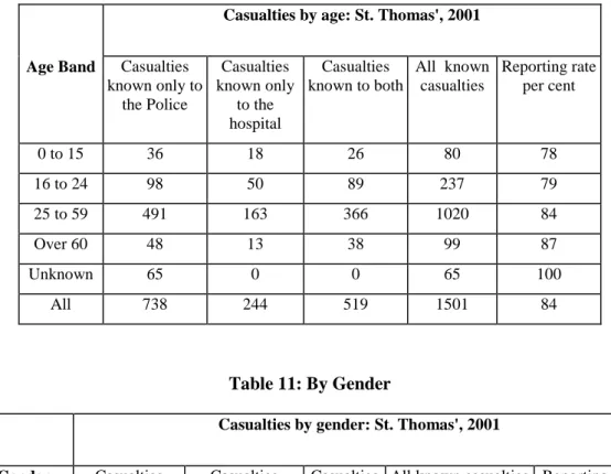
Age Band Casualties known only to the Police Casualties known only to the hospital Casualties known to both All known casualties Reporting rate per cent 0 to 15 36 18 26 80 78 16 to 24 98 50 89 237 79 25 to 59 491 163 366 1020 84 Over 60 48 13 38 99 87 Unknown 65 0 0 65 100 All 738 244 519 1501 84 Table 11: By Gender
Casualties by gender: St. Thomas', 2001
Gender Casualties known only to the Police Casualties known only to the hospital Casualties known to both
All known casualties Reporting rate per cent
Male 496 152 348 996 85
Female 242 92 171 505 82
All 738 244 519 1501 84
Table 12: By Severity
Casualties by severity: St. Thomas', 2001
Severity Casualties known only to the Police Casualties known only to the hospital Casualties known to both All known casualties Reporting rate per cent Fatal 5 0 3 8 100 Serious 62 46 122 230 80 Slight 671 193 394 1258 85 Unknown 0 5 0 5 0 All 738 244 519 1501 84
4.2.2 Lower estimates of reporting rate using All hospital data for inside and cross border casualties
Table 13: Overall numbers and lower estimate of reporting rate
All casualties: St. Thomas', 2001
Casualties known only to the Police Casualties known only to the hospital Casualties known to both All known casualties Reporting rate per cent
738 518 519 1775 71
Table 14: By Road User Class
Casualties by road user class: St. Thomas', 2001
Road User Class Casualties known only to the Police Casualties known only to the hospital Casualties known to both All known casualties Reporting rate per cent Pedestrian 126 115 132 373 69 Car, van, goods,
bus user 299 185 157 641 71 All others including PC and TWMV 313 218 230 761 71 All 738 518 519 1775 71 Table 15: By Age
Casualties by age: St. Thomas’, 2001
Age Band Casualties known only to the Police Casualties known only to the hospital Casualties known to both All known casualties Reporting rate per cent 0 to 15 36 37 26 99 63 16 to 24 98 97 89 284 66 25 to 59 491 355 366 1212 71 Over 60 48 29 38 115 75 Unknown 65 0 0 65 100 All 738 518 519 1775 71
Table 16: By Gender
Casualties by gender: St. Thomas’, 2001
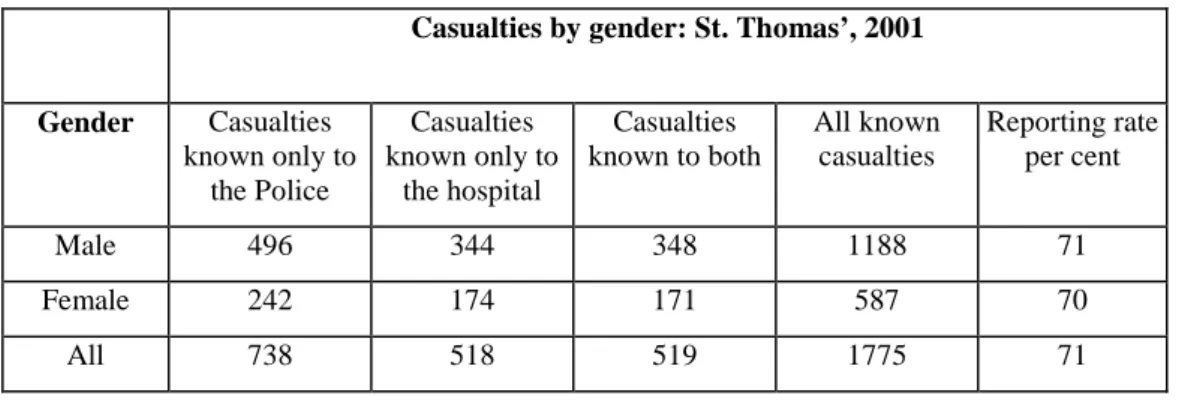
Gender Casualties known only to the Police Casualties known only to the hospital Casualties known to both All known casualties Reporting rate per cent Male 496 344 348 1188 71 Female 242 174 171 587 70 All 738 518 519 1775 71 Table 17: By Severity
Casualties by severity: St. Thomas’, 2001
Severity Casualties known only to the Police Casualties known only to the hospital Casualties known to both All known casualties Reporting rate per cent Fatal 5 0 3 8 100 Serious 62 121 122 305 60 Slight 671 391 394 1456 73 Unknown 0 6 0 6 0 All 738 518 519 1775 71
4.2.3 Best estimates of reporting rates using Hospital data for inside and estimated unmatched cross border casualties
Table 18: Overall numbers and best estimate of reporting rate
All casualties: St. Thomas', 2001
Casualties known only to the Police
Casualties known only to the hospital
Casualties known to both
All known casualties
Best estimate Reporting rate per
cent
738 328 519 1585 79
Table 19: Overall numbers and best estimate of reporting rate by road user class
Casualties by road user class: St. Thomas', 2001
Road User Class Casualties known only to the Police Casualties known only to the hospital Casualties known to both All known casualties Reporting rate per cent Pedestrian 126 73 132 331 78
Car, van, goods, bus user 299 119 157 575 79 All others including PC and TWMV 313 136 230 679 80 All 738 328 519 1585 79
Table 20: Overall numbers and best estimate of reporting rate by age
Casualties by age: St. Thomas', 2001
Age Band Casualties known only to the Police
Casualties known only to the hospital Casualties known to both All known casualties Reporting rate per cent 0 to 15 36 21 26 83 75 16 to 24 98 66 89 253 74 25 to 59 491 225 366 1082 79 Over 60 48 16 38 102 84 Unknown 65 0 0 65 100 All 738 328 519 1585 79
Table 21: Overall numbers and best estimate of reporting rate by gender
Casualties by gender: St. Thomas', 2001
Gender Casualties known only to the Police
Casualties known only to the hospital Casualties known to both All known casualties Reporting rate per cent Male 496 216 348 1060 80 Female 242 112 171 525 79 All 738 328 519 1585 79
Table 22: Overall numbers and best estimate of reporting rate by severity
Casualties by severity: St. Thomas', 2001
Severity Casualties known only to the Police
Casualties known only to the hospital Casualties known to both All known casualties Reporting rate per cent Fatal 5 0 3 8 100 Serious 62 69 122 253 73 Slight 671 254 394 1319 81 Unknown 0 5 0 5 0 All 738 328 519 1585 79
5. Interpretation
of
results
The results from matching St Thomas’ Hospital with STATS19 data indicate that the reporting rate to the police is about 79 percent of all casualties. This is higher than at both King’s College Hospital ( 71 percent - Inner London ) and at Barnet General (70 percent - Outer London) but lower than at St Mary’s (87 percent – Central London). From this extra analysis of St Thomas’ data it is suggested that:
• the level of reporting to the police in Central London is generally higher than that in Inner and Outer London, and
• the reporting rate calculated from St Mary’s Hospital data still seems on the high side. The analysis of the St Thomas’ data throws further doubt on the data from St Mary’s. St Mary’s A&E department has on average just over 63 000 attendances each year whilst St Thomas’ has about 108 000 attendances
(http://www.performance.doh.gov.uk/hospitalactivity/data_requests/index.htm). The
percentage of road traffic accident attendances to the total attendances is 1.07% for St Mary’s and 2.65% for St Thomas’. Repeating the calculation for King’s and Barnet the percentages are 2.12 and 1.53 respectively. Taking the average percentage road traffic casualties to all attendances at King’s, Barnet and St Thomas’ we would expect the number of road traffic accident casualties to be registered by St Mary’s to be nearer to 2000 per annum than the 929 reported. This suggests an incomplete dataset was used in the original analysis of St Mary’s. The lack of identifiable pedal cyclist and TWMV casualties in the St Thomas’ hospital record is a disappointment because these are two important road user groups. However, the data for the pedestrian casualties indicates that their injuries are generally well reported with a
reporting level of about 78 percent. Even if the lower estimate is used, then the reporting rate to the police is still high at 69 percent. The best estimate is similar to that found at St Mary’s but higher than that for the inner and outer London hospitals. It is difficult to assess
differences between hospitals in the number of pedestrian casualties and their reporting rate in the absence of exposure data for this group (and the pedal cycle and TWMV riders if we had their casualty information at the hospital).
Possible explanations for the high Central London reporting rates:
1. If a casualty feels well enough to continue home and once there if they or their GP consider there is a need for hospital treatment, they are more likely to go to their local
hospital and not back to the central London hospital near where they were injured. Therefore, for this unknown group of people, their injury will be in the police record and in the record of some other hospital unknown to us but not the hospital record being studied.
Lowdell et al (2002) in their study of injuries and accidents in London found that pedestrians were likely to be injured in the borough where they live, and pedal cyclists in the borough where they live or in an adjacent one. Drivers and riders of two wheeled motor vehicles are likely to be injured further from their home borough. Having said this there are substantial numbers, not quantified in the report, of road user casualties coming from elsewhere in London and outside. The borough with the highest number of road accident casualties is The City of Westminster with 2737 casualties in 2001, followed by Lambeth with 1928 (TfL 2002). Casualties from large parts of both these boroughs are likely to be taken to St Thomas’.
St Mary’s hospital is situated in the City of Westminster and St Thomas’, whilst in Lambeth, is just across the river from Westminster and is the nearest hospital to the southern part of it. Westminster has the most accidents of all London boroughs, has the lowest rate of injury to its own residents, and has the largest mix of casualties from other parts of London. An assumption that also may be made is that Westminster has the largest mix of casualties among people not living in London.
2. The level of police presence and awareness of traffic incidents in Central London means that when a road traffic accident occurs the police are more likely to be on the scene very quickly, thus making it more likely that the accident will be reported and appear in the STATS19 record.
6. Other
issues
In the previous report, an estimate was made of the number of people injured in road traffic accidents for the whole of London. This was achieved by using the relatively conservative estimate of 70 percent as the reporting rate to the police. This, together with the number of casualties reported to the police but absent from the hospital record, led to an estimate of 63 000 casualties on London’s roads in 2001.
Subsequently the total number of casualties has been re-estimated using the hospital activity data for London to estimate the number of A&E attendances for the groups of central, inner and outer London hospitals. For Central London there were about 398 000 attendances at A&E in 2000-01, the figures for inner London are 735 000 and for outer London 1.2m (see Table 23). Using the percentages of road traffic casualties to all attendances calculated using our representative hospitals (excluding St Mary’s), it is estimated that about 44 700 people attended the 33 A&E departments in London hospitals as road traffic casualties in 2000-01. Table 23: Estimates of numbers of road traffic accident casualties at London hospitals in 2000-01
Area of London Percentage of rta/all attendances from 3 sample hospitals
First attendance at A&E (DH data)
Estimated number of rta casualties for area
Central 2.65 397891 10555
Inner 2.12 735248 15590
Outer 1.54 1205096 18554
London 2338235 44700
Table 24: Estimates of the proportion of all casualties in both police and hospital record for three London hospitals.
Hospital area Casualties known only to police Casualties known only to hospital Casualties known to both police and hospital All known casualties Casualties known to both / all known casualties King’s (inner) 605 214 232 1051 0.221 St Thomas’ (central) 738 328 519 1585 0.327 Barnet (outer) 324 280 341 945 0.361 All areas 1667 822 1092 3581 0.305
There were about 44 500 casualties reported to the police but as shown in Table 24 this represents those known only to the police (i.e. do not appear in the hospital record) plus a proportion of those that appear in the hospital record. Similarly for the 44 700 people
estimated to be in the hospital records across London there will be those known only to the hospital plus a proportion that appear in the police record as well. From Table 24 it is
estimated that about 30.5 percent appear in both sets so the 89 200 people in the hospital and police records together represent about 130.5 percent of the number of people injured. This leads to an estimate of about 68 500 injured people on London’s roads in 2001. This is within the range of 63 000 to 73 000 previously reported
Still of interest is to investigate whether there is a better way of estimating the number of casualties occurring on cross-border roads given they make up a substantial proportion of the total number of casualties in the hospital dataset. It has not been immediately obvious how this might be done without more precise locational data from hospital records but work for the Department for Transport on investigating trends in serious accidents may afford an opportunity to look at data from other smaller areas of England and through this a more refined method may be investigated.
Lowdell et al’s (2002) work estimated that there were about 4300 hospital admissions each year for residents of London injured in road traffic accidents. In the course of the work for the DfT, the relationship between the number of casualties in the police record and those
admitted to hospital will also be investigated. This may provide a methodology for providing an additional estimate of the more serious injuries.
7.
Acknowledgements
The data was provided by Chris Lacey, A&E Consultant and Julie Herring, Emergency Department Service Manager at St Thomas’ Hospital.
8. References
Department of Health Hospital activity statistics, A&E Attendances.
(http://www.performance.doh.gov.uk/hospitalactivity/data_requests/index.htm) Lowdell C., Fitzpatrick J., Wallis R., Mindell J., and Jacobson B (2002) Too high a price.
Injuries ands accidents in London. Health of Londoners Programme Sept 2002. Pjsoft (1999) InfoMap ver.7.0,
Robertson S. and Ward H. (2002) Levels of reporting to the police of road traffic accident casualties 1996-2000. Unpublished report, centre for Transport Studies, UCL.
Simpson H.F. (1996) Comparison of hospital and police casualty data: A national study. TRL Report 173. TRL. Crowthorne.
Transport for London (2002) Accidents and Casualties in greater London during 2001. Fact Sheet - London Accident Analysis Unit Quarterly summary – Year 2001 (Final) May 2002
Ward H, Cave J, Morrison A, Allsop R , Evans A, Kuiper C and Willumsen L (1994) Pedestrian activity and accident risk. AA Foundation for Road Safety Research., Basingstoke.
Ward H., Robertson S., Lester T., and Pedler A. (2002) Under-reporting of road traffic accidents in London: Matching police STATS19 with hospital accident and
emergency department data. Unpublished TRL report PR/T/069/2002. TRL Limited, Crowthorne
Appendix 1: The data-matching process
A1.1 Sorting hospital records according to location in or outside the cordon
Sorting the hospital data is made difficult because only vague descriptions of location are given. Using InfoMap a list was extracted of all road lying within the cordon and each of the hospital records checked manually using the location information. This resulted in the records being partitioned into four sets:
1. Definitely in the area 2. Definitely not in the area
3. On a road that passes through the area and continues outside it, or on a road that starts (or finishes) in the area and crosses the boundary
4. Unknown location
A1.1.1 Procedure for estimating casualties on roads running through the area and out the other side?
Figure A1 illustrates the issues associated with set 3 in the list. Here we do not know whether the casualty was injured on the part of the road that is in the area or the part of the road that is outside the area. The size of these boundary data will differ according to the road characteristics of the cordon area. This has implications for the size of the hospital dataset and hence the denominator used in the calculation of reporting rate.
Figure A1. Schematic diagram of roads within and roads crossing the boundary to the study area.
Hospital data for casualties that occurred on roads with their entire length inside the catchment Hospital data for casualties that occurred on roads with some length inside the catchment and some length outside the catchment
Hospital data for casualties that occurred at some unknown or unspecified location Boundary of the catchment that all the police data lies within
For the STATS19 records we know they are all in the area (or at least we are assuming that the grid reference is correct) so these issues do not arise here.
If we use only the data that are known to be in the area for matching with STATS19 data we will be ‘discarding’ hospital casualties that lie on the roads passing through the area even though we cannot identify these records individually. We would therefore overestimate the reporting rate. See Figure A1.
However, if we include all the boundary data as being within the hospital set we will be overestimating the size of the hospital dataset and thereby underestimate the reporting rate.
The actual number of casualties known only to the hospital will lie somewhere between the values described above. In this report we have included the high and the low estimates of reporting rate together with an estimate of the actual value.
For the purposes of this report, we have made an estimate of the proportion of casualties that are known to the hospital only (unmatched hospital data in the boundary area) on roads which cross the boundary of the study area. This estimate is calculated separately for each hospital area and is based on the number of matched casualties known to be in the study area divided by the number of casualties in the hospital dataset that are known to be wholly within the study area. Then the number of casualties in the cross border dataset are divided by this proportion to give the total number of casualties we might expect to have occurred within the study area on the roads that cross the borders of the study area. To get to our final estimated number we then have to remove the casualties that are deemed to be outside the boundary but as we don’t know which these are we exclude, and put to one side, the ones that already match then remove the others according to a random selection process.
This estimate is the best that can be provided within the scope of this report and in terms of the time available for the analysis. We have made the assumption that the reporting and other casualty characteristics for casualties occurring within the study area are the same as those occurring on the roads crossing the boundaries of the study areas. This assumption is not very robust as the characteristics of roads that cross the study area
boundaries can be markedly different from those within the study area in terms of size, traffic flow, composition and numbers of casualties. An example of this would be the M1 in the Barnet study area. On the other hand, there are some roads which cross the study area that would be more typical of the roads found entirely within the study area.
A1.1.2 Hospital data whose location was unknown.
A similar approach could be applied to casualties known to the hospital only whose location was unknown. Time constraints did not permit a similar treatment at this stage. There were relatively few of these and it was concluded that the difference in the resulting estimate of numbers would not be great as there were few matches for casualties where the hospital location was unknown.
A1.2 The matching process
The matching process was undertaken in two stages with an automated and a manual component. The police data and hospital data (having been pre-processed to a consistent format) were placed on the same page of a spreadsheet which allowed automated and visual comparison of the two data sets. This section will describe the data sets used, and the matching process.
A1.2.1 The combined dataset
The data from the hospitals and from the police were converted to a compatible format for the matching exercise. This included parsing of date and time data to a form that could be used in a spreadsheet. These are shown below.
Police data was converted to:
Refnum Sex(p) Age(p) Cas Class(p)
Severity (p)
Date Police =1
Time East North Location Postcode Match Date
Hospital data was converted to:
Date Age(h) sex(h) Class(h) Severity(h )
Hospital= 2
RTA Date RTA Time Location of Accident
In area Ref number
There are two date fields in each of the data sets. The data field at the end of the police and the one at the beginning of the hospital data share the same spreadsheet column and for matched data become a common field. A further set of fields converted the police and hospital codes to a common set of codes that were used in the analyses. These fields were:
PHB Age(hp) Severity(ph) Class(ph) Year code sex(hp)
The field PHB identifies whether the line of data is known to police only, to hospital only or to both. The year code is to allow year by year comparison in the future.
A1.2.2 Data coding
Data coding was key to the success of the work. The data codings are shown in Appendix 3 of Ward et al (2002). Some of the key data coding issues are described below.
A1.2.2.1 Severity
The severity coding used was the STATS19 levels of killed, seriously injured and slightly injured. The hospital descriptions of severity were in the form of disposal codes or outcomes and these were mapped onto the STATS19 severity codes. Each hospital had a different set of disposal codes (or discharge outcomes) which were individually mapped on to the severity codes mapped.. These can be found in Appendix 2 of Ward et al (2002)
A1.2.2.2 Codes for vehicle class
The coding used for the class of a road user casualty by the police and by the hospital is different so a set of categories that encompassed both coding systems was required. The following categories encompassed both sets and have been used throughout the phases of the study:-
Pedestrian Pedal cycle
Two Wheeled Motor Vehicle
Car, bus , Heavy Goods Vehicle,Light Goods Vehicle ( etc Other ( horse, milk floats etc)
Unknown
Police user class data were taken as definitive for tables. It was assumed that the vehicle type was more likely to be correctly identified by police at the scene of the crash than by hospital A&E staff. The hospital user codes are shown in Appendix 3 of Ward et al (2002)
A1.2.2.3 Age band codes
Hospital age data were taken as definitive for tables. Where these were not available the police age data were used. The following age bands were used
0-15 16-24 25-59 60+ Unknown
A1.2.2.4 Codes for area
The locations of the hospital casualties were coded in terms of whether they were on roads that were within the study area. These data were used to allow selection for data for different analyses.
The categories were:-
On roads wholly within the study area.
On roads that were partially within the study area. On roads whose location was unknown.
On roads outside the study area.
A1.2.2.5 Codes for date and time
In some cases for police data, the time given has the same minutes and hours shown where the hours are greater than 23. This means that for the purposes of the analysis, the actual time of the incident is unknown and also cannot be handled by the matching algorithm. Such times are therefore coded in this analysis as 12:12. The use of 12:12 as an unknown time value provides a mid point during the day and allows the data to be included in the automated matching process. In some cases the time of incident recorded by the police is rounded to the nearest hour. The use of the value 12:12 also indicates that the value is likely to be a missing one and not a rounded one. For the hospital data, both the time of registration at the hospital and the time of the incident were recorded. Where the date of the incident date was missing it was replaced by the date of registry at the hospital. Where the incident time was missing this was set to 00:12 so as to be 12 hours from missing police incident time thus avoiding a spurious time match.
A1.3 The matching algorithm
Experiments were undertaken using 1 month of data to determine the effectiveness of various algorithms. 5 fields were used in the algorithm:
Date of incident
Date and time of incident (allowed incidents spanning midnight to be included) Age
Gender User class
A number of runs using different combinations of mandatory matches were undertaken and the total number of matches Number of matching variables Mandatory matching variables
Matches Of which false positives
5 All 12 0
4 Date 24 5 False 2 uncertain
4 Date & age 20 2 uncertain
4 Date & gender 20 2 uncertain
4 Date age & class 20 2 uncertain
4 Date & time 12 0
4 Date or time, and age & gender
20 2 uncertain
Given the high proportion of false positives obtained where 4/5 variables with same date were used it was decided not to investigate the effect of 3 matches. The algorithm finally selected for the auto matching was at least 4 of the above fields matching with the following fields mandatory.
• age
• gender
• date or time
A1.4 Automated matching
The data sheet consisted of two sets of columns of data one for the police and one for the hospital data with one common column for the date field. When two lines of data matched they were place in a single line. The matching process moved lines of hospital data to the same line as the matching police data. Codes for age gender and whether a given line contained data from police, hospital or both etc were calculated in further fields from which pivot tables were used to produce results tables.
The automated matching process used an algorithm written in visual basic for application running within an excel spreadsheet. The automated matching process was run using all police and all hospital data including those hospital data that had been provisionally identified as being outside the study area. This allowed a double check on the exclusion of hospital data. The automated matching process did not take account of the plain English description of locations.
Codes for matches were inserted in the matches field on the combined data page. A value was inserted to indicate a match a blank is left to indicate no match. In the auto sort routine, a number was also inserted where additional lines also matched the specific police data. These were used to help inform the manual matching process.
4 auto match 4 matching variables: - (Date or time) and (age and gender) 5 auto match 5 matching variables (date, time, age, gender, class)
The matching process was run on all police and all hospital data supplied (this included data which had been provisionally identified as outside the area so as to provide a double check on location data).
A1.5 Manual matching
After the automated matching process, a manual matching process was undertaken on the output of the automated matching process.
For the manual matching process there was an element of qualitative judgement applied to the matches based on the experience of the people undertaking the matching process. Possible additional matches and false matches were identified by one individual and the decisions on whether to include these were made by two or in difficult cases by 3 individuals.
The fields used in the manual matching process were:- Date
Age Gender User class
Location (plain English)
In some cases the following codes were included in the matched spreadsheet 6 Manual match where the matchers had high confidence.
7 Manual match where the matchers had less high confidence.
This process was undertaken on the matched datasheet. The datasheet used earlier to identify the location was not updated. Where matches were made on data that had been previously been identified as being outside the area, a careful examination of location information was undertaken. In some cases additional data that were within the area were identified. Matching lines of data were moved manually within the spreadsheet. The manual matching required some qualitative assessment. In a number of cases the original data had to be revisited especially where there were inconsistencies of date. An example would be where the date of incident was recorded by the hospital as being on one day and the date of registration at the hospital was recorded as being on the day before, as was the police record of the accident. Such a combination of factors would imply a match. other types of inconsistency included misuse of the 12/24 hour clock system so tie of incident could sometimes appear to be 12 hours apart.
A1.6 Selecting subsets of the data
The original matching exercise was undertaken on the full dataset, but for a number of the analyses a sub set of the data was required, (for example hospital casualties on roads that were entirely from within the study area only). Where subsets of the data were required, the unwanted hospital data was identified by sorting on the "in area" field then removing the unwanted hospital data and saving the spreadsheet under a new name.