Cerro Cumbray: A Chimú Frontier Outpost
By
Matt Ballance
Senior Honors Thesis
Department Of Anthropology
University of North Carolina – Chapel Hill
Thursday, April 4, 2019
Approved:
TABLE OF CONTENTS
CHAPTER PAGE
Acknowledgments ... 4
Preface ... 5
Introduction ... 6
CHAPTER 1 – The Lay of the Land ... 8
CHAPTER 2 – Arch Rivals ... 15
CHAPTER 3 – A Fort by Any Other Name ... 31
CHAPTER 4 – MV-323 Cerro Cumbray ... 35
CHAPTER 5 – A View to Kill ... 51
CHAPTER 6 – Conclusions ... 61
BIBLIOGRAPHY ... 65
List of Figures Figure PAGE 1. A visualization of Vidal's ecological zones ... 9
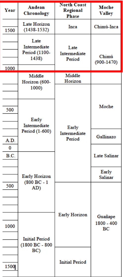
2. A partial chronological sequence for the Moche Valley and Andes at Large ... 12
3. Plan of Rivero Ciudadela ... 17
4. A possible sequence of Chimú Expansion ... 21
5. An Inka Captain facing a jaguar, armed with a bow and arrow, in a wooded environment... 25
6. An Inka Captain engaged in a siege ... 26
7. Areas of concentrated Inka fortifications ... 28
8. The distribution of PD’s or surface survey points at Cerro Cumbray ... 37
9. The Author piloting the Phantom 4 drone from the summit of Cerro Cumbray ... 39
10. The Cerro Cumbray Gate from Below and Above ... 41
13. Total distribution of lithics per square meter, by PD. ... 44
14. Marine shell found at Cerro Cumbray ... 45
15. The bastion at the western end of Sector 3 under normal light. ... 47
16. The bastion at the western end of Sector 3 under hillshading ... 47
17. The points, least cost paths, and viewsheds discussed in Chapter Five – Large Scale ... 54
18. The points, least cost paths, and viewsheds discussed in Chapter Five – Small Scale. ... 55
19. Comparison of slope raster before and after reclassification. ... 56
20. Comparison of slope raster before and after reclassification. ... 56
21. The cost distance raster for Cerro Ramon ... 57
22. The cost backlink raster for Cerro Ramon ... 57
List of Tables Table PAGE 1. Diagnostic Sherds from Sector 1 ... 43
2. Diagnostic Sherds from Sector 2 ... 44
3. Diagnostic Sherds from Sector 3 ... 46
4. Diagnostic Sherds from Sector 4 ... 48
5. Results of Viewshed intersections with 10m buffer polygons. ... 58
Acknowledgements
There are a number of people who made this work possible. I was firstly supported by my
parents Kevin and Julie Ballance, who encouraged me to pursue archaeology against their better
judgement. I was mentored in Andean archaeology by Dr. Brian Billman as a field school
student. I’m forever grateful to him and his wife Laurie, who nursed me back to health after I
was diagnosed with Bronchitis during the field season. I’m also thankful to Patrick Mullins, who
took me under his wing and his roof during the field season, and taught me the Moche Valley
ceramic sequence. I’d like to apologize for the poor quality of the rim sherd drawings I
contributed to his dissertation, but I’m thankful for his patience. I’d like to thank Robby
Valderrama for his assistance with the fieldwork at Cerro Cumbray and his patience with my
bumbling Spanish. Finally, I’d like to thank the UNC Office of Undergraduate Research who
Preface
Cerro Cumbray wasn’t the first site I would’ve chosen. It doesn’t have grand
fortifications, or much standing architecture of any kind. Nevertheless, when illness derailed my
initial research plans, I resigned myself to it.
The ceramics scattered across the ground are, for the most part, utilitarian wares. Rather
than the complex and beautifully decorated ceramics I’d seen in museums, I was met with a
collection of red, brown, and black earthenwares unremarkable in both form and decoration. I
wasn’t immediately thrilled.
However, the more I looked, the more the little site had me hooked. Little hints kept
popping up: the distribution of certain types of rim sherds, the one intact seashell, the tiny pile of
slingstones. Each added a tiny piece to the puzzle.
That puzzle is far from complete. Nevertheless, the following chapters represent my best
understanding of the way that the people of Cerro Cumbray lived.
Likewise, I wanted to understand the world that Cerro Cumbray sat in the middle of.
Cerro Cumbray, like many other sites in the Upper Moche and Sinsicap Valleys, sits on a
precipice. Dividing coastal and highland populations, these seemingly inconsequential hilltop
sites have an incredible amount to say about one of the most tumultuous and violent times in
Introduction
In order to understand how the residents of Cerro Cumbray participated in a contest
between the Chimú and Inka Empires, it is first necessary to understand the playing field. As
such, Chapter One focuses on the ecology and prehistory of the Moche Valley.
Chapter Two introduces the two empires. The Chimú Empire is discussed from the
perspective both of its capital city as well as its territorial expansion. The Inka Empire is
examined through an archaeological and ethnohistoric lens. A particular focus is placed on the
ways that the Inka incorporated territory both diplomatically and violently, and what that implies
for the conquest of the Chimú. This chapter forms the basis for later discussions of coastal
highland interaction, using GIS techniques to supplement the historical and archaeological
record.
Chapter Three initially discusses the problems and opportunities involved with
identifying prehistoric fortifications. Later, two different perspectives on Andean fortifications
are presented. Both sides are used as a critical lens to examine the extent to which Cerro
Cumbray was simultaneously fortified and accessible. The defensive characteristics discussed by
Keeley et. al, Arkush and Stannish, and Topic and Topic as well as Cerro Cumbray’s naturally
defensive position are synthesized in Chapter Four.
Chapter Four presents an in depth discussion of the survey of Cerro Cumbray. First, the
two distinct methods and process used to survey the site are established. Firstly, a systematic
pedestrian survey was performed that resulted in the collection of large amounts of ceramic data.
support and corroborate the other. The presentation of ceramic and other artifactual data over the
drone based imagery allows for easy analysis and a better understanding of the spatial divisions
at the site.
At a larger scale, Chapter Five discusses the use of GIS techniques to analyze Cerro
Cumbray’s place on the landscape. A sequence of three highland sites are presented as likely
jumping off points for an invasion of the coast. A least cost path is derived using a DEM of the
region from each point to Chan Chan, the Chimu capital. Each path is then analyzed with regards
to its intersection or overlap with regards to three distinct viewsheds from the summit of Cerro
Cumbray. The chapter concludes with a speculative discussion of Cumbray’s place in the Chimú
network.
Chapter Six briefly synthesizes and presents the conclusions from the previous five
chapters and presents my final thoughts on the project. Chapter six concludes with a reflection on
the successes and limitations of the project and some promising opportunities for future
Chapter One – The Lay of the Land
Moche Valley Ecology
The Moche Valley is much like many of the other river valleys on the coast of Peru. It is
visible on modern satellite imagery as a thin ribbon of green that cuts through an arid coastal
desert. The valley also serves as a connection between the productive fisheries of the coast and
the agriculturally limited zones of the cold highlands. Connecting these two distinct extremes are
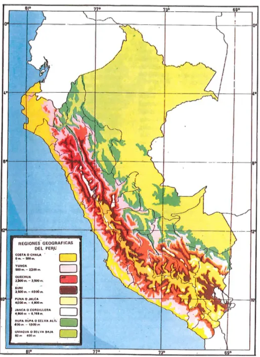
a vertical sequence of 8 “natural regions”, first named by Vidal (1990). From roughly east to
west these regions are: the Chala or coast(0-500m), the Yunga (500-2300m), the Quechua
(2300-3500m), the Suni (3500-4000m), the Puna (4000-4800m), the Janca or Cordillera
(4800-6768m), the Selva Alta (400-1000m), and the Selva Baja (80-400m). While these zones were all
codependently linked in Andean prehistory, this paper will focus on the zones most crucial to the
Figure 1. A visualization of Vidal's ecological zones. From Zimmerer and Bell 2013.
The coast refers to the region bounded by the Pacific ocean and the foothills of the Andes
that ranges from 0 to approximately 500 meters in elevation. The coast is dominated by a
seeming dichotomy between the rich marine fisheries of the Humboldt current and the arid desert
outside the narrow river valleys. As a result, coastal populations developed subsistence systems
As such, the Coast has historically been especially susceptible to ENSO (El Niño
Southern Oscillation) events. These large scale climatic events occur when Pacific ocean
currents reverse, and warm equatorial waters flow south down the usually frigid pacific coast of
South America. As a result, large scale die-offs of marine fish occur as water temperatures
exceed their survival threshold. On land, the normally arid desert is inundated by torrential rains.
This in turn leads to catastrophic flooding damage and loss of agricultural infrastructure. Recent
archaeological research has examined the relationship that the peoples of Peru’s prehistoric coast
had with ENSO events, and how they accommodated these apocalyptic events into their
cosmovision (Prieto et al. 2019).
These effects were not, however, limited to the coast. Further up the river valleys the
yunga zone emerges. Located between 500 and 2300 meters in elevation, and with more fertile
soils than the arid coast, the yunga provides a prime site for agricultural production. Production
is most intense in the narrow chaupiyunga band, a zone between 800-1200m. Here the
microclimate is particularly suited to the production of coca and maize. Both were coveted
resources in Andean prehistory. Coca was prized for its stimulating effects, while maize was
highly valued for its ability to be fermented into chicha, an alcoholic maize beer. The coca from
the western chaupiyunga was especially prized for its sweeter taste in comparison to coca grown
in the ceja de la montaña on the eastern slopes of the Andes (Malpass 2016: 21).
In this zone El Niño events can cause devastating rainfall, but the ensuing moisture also
periodically turns the desert into perfect pasture for camelid herds. As a result of these
properties, the yunga was highly contested in Andean prehistory with coastal and highland
polities jockeying for control of its resources. Cerro Cumbray is located on the low margin of
Above the yunga zone, the quechua emerges. While this zone lies outside the immediate
survey area, it is nevertheless important to mention it in regards to highland polities. Located
between 2300-3500 meters, the quechua zone produces a substantial amount of maize. In the
Late Horizon, this maize was collected by the Inka Empire along with potatoes grown at higher
altitudes and put into state storehouses. It was also used to produce large amounts of chicha. It
was only through the large scale production of maize and that Inka military forces and corvée
labor divisions could be provisioned. The quechua zone is relevant to this thesis in that the late
horizon fortified sites identified by Coupland serve to mark the zones lower boundary.
While not especially relevant to the focus of this thesis, the upper zones of the Suni,
Puna, and Cordillera are worth a brief mention. They were, respectively, focal points of: potatoes
and high altitude grains such as quinoa, pasture for grazing camelids, and the spiritually
significant snow covered mountain peaks of the high Andes. The selva alta and selva baja refer
to higher and lower zones of moist forest on the east slopes of the Andes, bordering the amazon
basin.
Each of these vertical zones are important in Andean prehistory. In his influential work
on the Inka empire, John Murra (1980) termed the connections between populations at different
elevations “vertical archipelagos.” He saw these vertical ecological zones as being
complementary in many ways, each producing goods necessary to the other regions. Zones
which produced especially important goods used for ritual or conspicuous consumption were
zones of increased conflict. In terms of this study, the most important resources were coca,
produced in the Chaupiyunga and maize produced in the Quechua (Boswell 2016). It’s likely that
competition over control of these resources represents an impetus for at least some of the site
Prehistoric Sequence of the Moche Valley
The prehistory of Andean South America is divided into a sequence of Horizons and
Intermediate Periods. Each horizon represents a time period where a certain culture seems to
have established widespread popularity or dominance. Each period, conversely, represents a
temporal division wherein Andean societies were more regionally or locally focused and thus
exhibit greater variation. This system was codified into the
Rowe-Menzel system. The Rowe-Menzel system divides
Andean prehistory into eight general phases, which can be made
more specific for the region of interest.
Humans first inhabited the continent of south America
sometime after the end of the last ice age. This initial period is
termed the “lithic” after the fluted projectile points that appear
in both North and South America. Evidence from the site of
Monte Verde suggests that humans had reached the southern tip
of South America by approximately 13,000 years BP (Moseley
2001). Andean peoples of the Lithic period were sustained
mostly by hunting and gathering (in the highlands) or by fishing
and the collection of marine resources (on the coast).
The next period is defined more by climatic change than
by cultural shift. The Preceramic, which follows the lithic, is
defined as coinciding with the end of glacial melting. When the
climate entered its current pattern, approximately 5,000 years ago, sea levels and weather
patterns stabilized. Populations became increasingly sedentary (Moseley 2001). Evidence of
simple agriculture in the Moche Valley dates back to the Late Preceramic, prior to the
intensification of irrigation (Billman 2002). As the name would suggest, this period ends with the
introduction of pottery approximately 1800 BCE.
The initial period, beginning in 1800 BC is primarily associated with the widespread
adoption of irrigation agriculture (Moseley 2001). On a local level, the initial period coincides
with the beginning of the Guañape Phase in the Moche Valley. At this time, a significant
population shift occurred with coastal populations settling in the valley to take advantage of
irrigable land (Billman 2002).
By 400 BC, the Guañape Phase in the Moche Valley was giving way to the Salinar Phase.
This phase was characterized by continuing irrigation development and by the end of the period
virtually all the irrigable land in the valley had been developed (Billman 2002). Food production
increased and consequently population expanded significantly. Settlements often shifted to more
defensive locations, and the first fortifications in the Moche Valley emerged (Mullins 2012).
The Salinar Phase was followed by the Gallinazo Phase, in which one site came to
dominate the lower valley and monumental architecture was revived. Further up the valley,
highland settlements emerged that may represent increased highland migration into the valley.
This increased migration may well have led to tension, and these settlements may represent the
beginnings of violent highland-coastal conflict in the Moche Valley (Mullins 2012; Billman
2002). Further investigation is needed to clarify the exact relationships between highland and
coastal populations in the Gallinazo period. The Gallinazo Phase ends with the beginning of the
The Moche period is perhaps the best known period of the north coast cultural sequence.
Moche public architecture is remarkably consistent across the region, showing a similar color
palette and a planned architectural schema. These sites were also the locations of carefully
choreographed human sacrifice events. Initially, it was believed that the sacrifices were losers in
ritual combat between Moche elites. More recent bioarchaeological investigation has uncovered
strong evidence that Moche sacrificial victims were prisoners taken in territorial conflict with
highland populations (Sutter and Verano 2006).
While there is little evidence of fortification in the Moche Phase, this territorial warfare
can be supported by the contemporary abandonment of many local highland communities
(Billman 2002).
The Southern Moche State declined sometime between 750 and 900 CE, likely due to
climatic events which weakened the prestige of the ruling class and destabilized subsistence
systems. Between 900 and 1000 CE, there was little central political organization in the Moche
Valley. A hierarchical state reemerges during the Late Intermediate Period in the form of the
Chimú Empire. The Chimú Empire, and their highland rivals the Inka will be discussed in further
Chapter Two – Arch Rivals
The Chimú: Foundations and Capital
Beginning sometime around 1000 CE, the Chimú Empire emerged on the north coast of
Peru. Following Rowe’s Andean chronology, the formation of the Chimú Empire coincides with
the beginning of the Late Intermediate Period (LIP). At a smaller scale, the Chimú chronology is
divide into Early Chimú (approximately 900-1000AD) and Middle/Late Chimú (1000 AD to
Inka conquest around 1470). These stages are useful in considering the process that transformed
the Chimú Empire from a local power to a territorial empire.
The initial seed of this power was rooted at the site of Chan Chan. Located on the coast
just outside the modern city of Trujillo, Chan Chan became the seat of political power in the
Moche Valley a brief time after the demise of Gallindo, the last vestige of Moche power in the
valley. Some have even argued that populations from Gallindo where involved in the initial
construction phases at Chan Chan, citing architectural similarities between Galindo and the
initial phase of construction at Chan Chan (Kolata 1982). As time passed, further architectural
developments were made in a uniquely Chimú style.
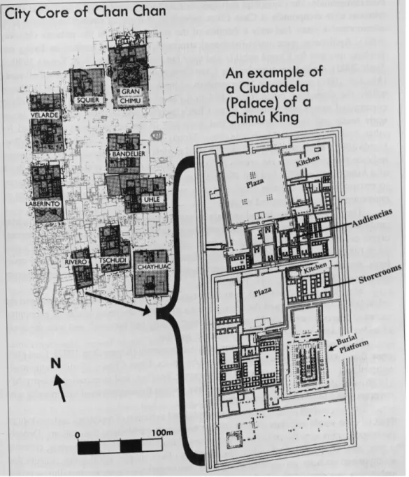
Among the unique architectural features of the city’s urban center are: temples known as
huacas, palatial buildings known as ciudadelas, and U shaped plazas known as audiencias. Each
represents a vital arm of political control. Residential structures can be divided into two main
categories: elite residential structures proximal to the ciudadelas, and lower class residences
known as SIAR (small irregularly agglutinated rooms) which are located near certain ciudadelas
as well as around the outskirts of the city (J. Topic 1982). While these structural types are all
spatially and temporally interrelated, it is necessary to discuss each in turn in order to then
Chan Chan: Monumental Architecture
Chan Chan has four named huacas, most of which lie further from the center of the city
than the ciudadelas and audiencias. In the case of Chan Chan, the huacas are large adobe terraced
mound structures. While the archaeological investigation of the huacas has been limited due to
extensive looting during the colonial period, it can be generally observed that the size of the
huaca structures decreases through time (Moore 1996: 85). This may be a result of the increasing
relative power of the ciudadela complexes.
There are nine definitive ciudadelas at Chan Chan, with a tenth enclosure known as Tello
falling outside the normal schema. All are rectangular and roughly oriented along a north south
axis. Size range from 88,790 m2 to 221,000 m2, with an average of 140,000 m2 (Day 1982).
Each ciudadela is surrounded by high walls with a single door that leads into a narrow corridor.
These controlled access points lead to a wide plaza on the north end of the complex. These
plazas were often encircled by benches and decorated with repetitive friezes. These plazas likely
represent the deepest that non-elites could penetrate the ciudadela complexes. Two sectors to the
south in the ciudadelas likely represent spaces for elite bargaining and royal residences,
respectively. These are marked as elite spaces due to their restricted access and increasing
proximity to the burial mound, located in the southeast corner (Day 1982).
Elite access to the ciudadelas was another matter entirely. After passing through the
narrow entrance and wide plaza space, elite members of society could ascend a ramp to enter the
central and northern sectors of the ciudadela. These sectors are distinguished by the presence of
numerous storerooms as well as the audiencias. Audiencias were square rooms, open at one end,
with niched walls and cane or reed roofs. These roofs were supported by large wooden posts that
Figure 3. Plan of Rivero Ciudadela. From Moore and Mackey 2008.
While the exact functions of audiencias is still a contested issue, it is clear that access to
them was highly controlled. One interpretation views the audiencias as administrative ‘offices’
where bureaucratic negotiation took place. Supporters of this theory cite the spatial relationship
between the audiencias and the storerooms (Keatinge and Conrad 1983). Others have critiqued
this interpretation, claiming that the connection between audiencias and storerooms has been
is supported by the presence of sub-floor dedicatory burials and by the analogous ceremonial use
of wall niches elsewhere in the Andes. It’s possible that in reality the purpose of the audiencias
fell somewhere in between the two extremes, coopting religious authority to legitimize political
power.
Chan Chan: Residential Structures
Residential structures at Chan Chan can be divided into two main categories: elite
compounds and SIAR (small irregularly agglutinated rooms) (J Topic 1982). Like many
pre-industrial cities, Chan Chan is marked by a rigid division between an elite upper class (topped by
royalty who lived inside the ciudadelas) and a larger working class. This division is reflected in
residential structures.
Elite complexes are marked by features they share with ciudadelas, only at a smaller
scale. Elite compounds are encircled by high walls with few entrances. They contain U-shaped
structures similar to audiencias. Approximately one quarter of elite compounds contain
storerooms (Klymyshyn 1982). Elite complexes also had priority access to water, with 28% of
wells being associated with elite compounds while only 12% were associated with SIAR’s. This
is significant due to Chan Chan’s desert location. Thus elite compounds can be defined by their
enclosing walls, restricted entry, and access to water. While elite residences are marked by these
dividing factors, they are not consistently spatially separated from the SIAR compounds. Rather,
they are often proximal.
The SIAR can be divided into two main blocks: those on the outskirts at the southern and
western edges of the city, and those associated with elite compounds in the center. Both types
have been interpreted as combined living spaces and workshops for Chan Chan’s lower class.
retainer relationship with the residences of the elite compounds. SIAR units of both kinds have
been interpreted as housing for a sort of urban proletariat, who exchanged craft goods for access
to wells and foodstuffs stored in the ciudadelas and elite compounds (J Topic 1982). While there
was undoubtedly some variation in social status among SIAR residents, it seems clear that they
were rigidly defined as being outside the nobility. Nevertheless, they engaged in reciprocal
economic relationships with the nobility.
This reciprocal economic relationship is exemplified by the complementary residential
pattern in urban Chan Chan. However, an increasing urban population at Chan Chan necessitated
the acquisition of increased land and labor to maintain this economic system.
The Chimú: Imperial Expansion
By 1200 CE, the Chimú had conquered their immediate area. In order to expand their
resource pool the Chimú state needed to acquire more territory and/or improve their current
territory. With control of the Moche, Chicama and Viru valleys the immediate security of Chan
Chan was assured. The Chimú administration then set to work improving this immediate area to
increase its productivity.
This was primarily accomplished through the construction of vast irrigation networks.
Often, many components of these irrigation systems were pre-existing and were revitalized by
the Chimú. In the end, the Pre-Columbian extent of irrigated land in the Moche valley was at
least 30% greater than the area sustained by modern irrigation practices (Moore and Mackey
2008: 787). The Chimú also established satellite outposts that provided access to specific
agricultural products. The site of Cerro la Virgen, for example, specialized in the production of
cotton (Pozorski and Pozorski 1979). However, it soon became apparent that supporting the
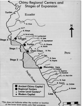
While the exact chronology of Chimú expansion is still debated, the process of expansion
is generally agreed to have begun sometime in the 12th century and to have reached its apogee by
the turn of the 15th century. Several competing theories of Chimú expansion exist, but Theresa
Topic’s 1990 sequence is useful in its discussion of Chimú expansion up the course of the Moche
River rather than north to south along the coast.
Topic (1990) describes this first phase from 900 to 1050 CE as being one of local
consolidation. In this period, the Chimú extended their frontier to the lower edge of the
chaupiyunga zone. At this juncture, a Chimú labor force constructed wall over 1km long as a
frontier demarcation. Two fortified sites placed lower in the valley served as the muscle to
enforce this territorial claim. Due to Cerro Cumbray’s location in the Sinsicap valley inland of
this demarcation, it is likely the site was not yet occupied during this period.
Chimú expansion further inland took place during a second phase. Between 1130-1200
CE the Chimú expanded their territorial control further inland, reaching into the Sinsicap and La
Cuesta Valleys and consolidating control of the upper Moche. As the Chimú reached past the
costa-chaupiyunga boundary into prime coca producing territory, they constructed fortresses to
embody their claim to this valuable commodity (Topic 1990). They also constructed several
fortifications along major roadways, perhaps in an attempt to control trade routes connecting
coastal and highland communities (Boswell 2016). Cerro Cumbray’s situation in the lower
chaupiyunga, and its location approximately 3km north of the Sinsicap-Moche juncture signal
that the site most likely dates to this period at the earliest. The limited ceramic evidence noted
during pedestrian survey would similarly place Cerro Cumbray in this mid to late Chimú period.
Further imperial expansion took place outside of the Moche Valley, but the timeline of
this expansion has been a subject of debate. Topic (1990) argues for an initial phase of
north-south expansion that coincided with the consolidation of the upper Moche Valley, between
1130-1200. Topic’s third phase, between 1300 and 1400, represents the final expansion of Chimú
influence from Tumbes in the north to Chillon in the south. A new chronology proposed by
Moore and Mackey (2008) agrees on the initial two phases, but proposes a date of 1320 for the
first expansion outside the imperial heartland. Moore and Mackey also express doubts
concerning the exact nature of imperial hegemony in the outlying provinces (Figure 4). They
propose that areas north of Tucumé and south of the Casma valley “interacted with, but were not
directly integrated into, the Chimú administrative hierarchy (Moore and Mackey 2008: 789).”
While little evidence regarding Chimú strategy or military tactics is available, it is not a
stretch to imagine that areas nearer to Chan Chan were more likely to have been conquered using
direct force, while more distant areas were more likely to enter into a client state relationship. It’s
also possible that like the Inka, the Chimú were prepared to accept cooperative populations
nonviolently while exacting a heavy toll from populations that resisted.
Ironically, the Chimú themselves would be violently conquered only a few generations
later. The date for the fall of the Chimú empire is traditionally given as 1470. Ethnohistoric
sources describe both an initial conquest by Topa Inka Yupanki, as well as a rebellion crushed by
his son Huayna Capac (Rostworowski 1999: 78-89). While an ultimate battle likely spelled the
end for the Chimú empire, Inka conquest of the north coast was a long and gradual process. In
order to understand Chimú response to Inka expansion, it is therefore necessary to understand the
formation and expansion of the Inka Empire.
The Inka: Consolidation and Imperial Expansion
The Inka Empire would grow to become the largest land empire in South America prior
to the Spanish Invasion. What began as a “moderately complex group of maize farmers” would
grow into an imperial tour de force (Covey 2008: 812). Inka origin myths explained this meteoric
rise to power as being due to divine blessing, the Inka royalty were sons of the sun.
Archaeological evidence indicates only that by 1300 CE the Inka had dominion over Cusco and
an area of 50-70km around it, with significant territorial campaigns beginning approximately 100
years later (Covey 2008).
The leader credited with the transformation of the Inka state was Pachakuti, a son of the
eighth king of a small Cusco polity. Pachakuti defeated the Inka’s biggest rivals, the Chankas, in
brother, the heir, executed for cowardice. He then seized political control (Gamboa 1532:
104-106). It’s almost certain that Pachakuti did not defeat the Chankas single-handedly. These events
may well represent a revisionist history designed to legitimize a violent coup. Whatever the case,
these events made Pachacuti the sole leader of a kingdom primed to expand. So radical was the
change that Pachacuti’s name can be translated either as the literal “earth shaker”, or the more
profound “reformer of the world” (Cameron 1990, 58). By the end of his reign Pachacuti had
subjugated much of the central Andean highlands. The conquests of the coast and the southern
Andes were left to his son, Topa Inka Yupanki.
Topa Inka Yupanki expanded the Inka Empire by the greatest land area of any single
ruler. He oversaw the conquest of the Inka’s greatest rivals, the Chimú (Moore and Mackey
2008). He extended the empire’s reach north to Ecuador and south to northern Argentina. He’s
also remarkable for his organizational efforts. By expanding the qhapaq ñan, the Inka royal
highway, and organizing his subjects into a decimal bureaucracy he increased both agricultural
productivity and military efficiency (Guaman Poma 1615: 141-161). While his tactical victories
were impressive, it is these infrastructural developments which paved the way for further Inka
conquest. They enabled Topa Inka Yupanki’s son, Huayna Capac, to continue his expansion.
Huayna Capac pushed the empire north and south. In the south, he moved deeper into
modern Argentina and Chile. In the north he was determined to expand the Inka empire into
modern day Colombia, though he was stalled by fortified local resistance (Guaman Poma 1615:
182-185). He also reconquered the Chimú and depopulated the city of Chan Chan, following a
revolt against Inka authority (Rostworowski 1999: 89). These sorts of rebellions were not
fact designed to respond to this process of rebellion and reconquest, supported by an efficiently
designed infrastructure system.
The Inka: Tactics and Strategy
While Inka battle tactics have not been the subject of much in depth study, there are
nevertheless some things that seem clear about how Inka commanders approached military
engagements. Firstly, they preferred to avoid them. By massing troops at the border of an
objective territory, Inka commanders tried to force local leaders to the negotiating table. If local
elites submitted peacefully, they would be celebrated and in many cases maintain a significant
level of agency (D’Altroy 1992; Ogburn 2014).
If the Inka’s generous offer was refused, they relied on mass attacks by groups of
conscript soldiers (Ogburn 2014). Many of these infantrymen were drawn from the provinces.
Officers were typically either ethnically Inka or Inkas by privilege, an honor that could be
bestowed as reward for loyalty or military achievement (Bram 1966: 47). The primary hand to
hand weapons were maces, clubs, axes, and spears. At range, Inka forces employed the sling to
great effect (Arkush and Tung 2013). Troops drawn from the eastern, Amazonian region of the
Andes were particularly skilled in the use of the bow and arrow (Guaman Poma 1615: 120; Cobo
Documentary evidence that the Inka military, especially under the command of Huayna
Capac, also engaged in sieges (Guaman Poma 1615: 122; Gamboa 1532: 159-166).
Early written evidence also suggests that upon the conquest of a resistant population, the
Inka were prepared to commit systematic executions as a form of reputation management.
Recent bioarchaeological investigations have discovered suggestive evidence of the Inka
massacre of a rebellious Chachapoyas population (Toyne and Vargas 2014).
On a strategic level, the Inka road system was designed for the rapid and well supplied
movement of troops. The economic foundation of the Inka empire was a system of corvée labor
known as the mita. Mita laborers could be conscripted into military service, or used to construct
roads or work the fields (Murra 1980). During their period of service, mita laborers were
provided food and clothing by the state (Murra 1980). Using this large labor force, the Inka were
able to construct a massive highway network. Along the roads, the Inka constructed storehouses
and way stations known as tambos, to supply military expeditions. These tambos were built at
distances commensurate with the distance men and llama trains could travel in a day. Major
centers were placed approximately one week apart and were stocked with surplus food and
clothing (D’Altroy 1992). Messengers known as chaskis were employed to run great distances
relay style. This allowed for the rapid transmission of military intelligence. Inka fortifications
were unsurprisingly concentrated at the northern, southern, and eastern frontier (Covey 2008)
Figure 7. Areas of concentrated Inka fortifications. From Covey 2008.
This system of roads and supply depots allowed for rapid movement of troops both to defend the
frontier as well as to quell rebellions. This system of provisioning and mobility allowed the Inka
Inka-Chimú Conflict
Perhaps anticipating eventual conflict with an expanding highland enemy, the Chimú
heavily fortified their territory. Unfortunately, the Inka system of warfare discussed above
enabled Inka forces to flank the Chimú, conquering local chiefdoms one by one until they
reached Cajamarca. While the river valleys between Cajamarca had been fortified as a result of
centuries long conflict between the Chimú and various small highland polities, they nevertheless
represented the path of least resistance to Chan Chan. One account describes forces led on the
ground by the brother of Inka Topa Yupanki, who disobeyed his brother’s orders not to advance
in pursuit of a rebellious Chanca army.
Going after [the Chancas], [Capac Yupanqui] reached Cajamarca, crossing the borders that the Inca had instructed him not to pass. Although he remembered the orders of the Inca, he decided to conquer the province of Cajamarca, since he was already there, even though he did not have his brother's permission to do so. This province was densely populated and was rich in gold and silver, thanks to great cinchi1named Guzmano Capac
who lived there and who was a great tyrant who had robbed many provinces surrounding Cajamarca. As Capac Yupanqui entered the land of Cajamarca, Guzmano Capac learned of it. He prepared his men and called another cinchi, his tributary named Chimo Capac, the cinchi of the area where the city of Trujillo is now, on the coast of Peru. Combining their forces, they came in search of Capac Yupanqui, who defeated them with an ambush and other ruses that he placed for them. He routed and captured the two cinchis,
Guzmano Capac and Chimo Capac, and acquired innumerable riches of gold and silver and other precious things, such as precious stones and red shells, which these natives then esteemed more than silver or gold. (Pedro Sarmiento de Gamboa 1532, 134)
Interestingly, this account presents a pre-existing perhaps even tributary relationship
between Guzmano’s highland kingdom and the Chimú leadership. This may also be a Spanish
misunderstanding of the periodic raiding of the coast by highland populations in pursuit of “gold
and silver”, represented as Guzmano Capac as having “robbed many provinces surrounding
Cajamarca.” The Chimú may not have been true subjects, rather they may have been paying a
nominal sum to highland groups to avoid violent incursions into their territory.
Other accounts of the conquest portray an even more aggressive Inka strategy. They
describe an attack that descended the Moche River with the goal of disrupting Chimú irrigation
and laying siege to the city of Chan Chan by disrupting its food supply (Rostworowski 1999:
78). While this is possible, it would have meant bypassing or subduing a number of fortresses
between Cajamarca and Chan Chan. As a means of testing these theories, I present a number of
possible invasion routes in Chapter 5. Each begins at a site that has archaeological or historical
evidence of Inka presence, and ends at Chan Chan. Using GIS techniques, I explore the
likelihood of each invasion path activating the a defensive response from the site of Cerro
Chapter Three: A Fort by Any Other Name
Archaeologists working in the New World often feel a desire to make up for the mistakes
of a colonial past by working to counter notions of Indigenous Americans as violent savages.
However, this can have dangerous ramifications. Violence in prehistory was not an everyday
occurrence, but neither was it uncommon. To insist otherwise is to infantilize indigenous peoples
and to engage with the notion of the noble savage, an equally damaging stereotype.
In a 2007 article, Keeley, Fontana and Quick brought attention to this dilemma and in
response discussed features of archaeological sites which are considered universally military in
nature. Their stated goal was to “counter a long standing tendency of prehistoric archaeologists
to dismiss or ignore the defensive functions and military significance of the large scale features
they excavate and analyze” (Keeley et al. 2007: 56). The authors identified three specific
characteristics of fortified sites: V-sectioned ditches, defended gates, and bastions (Keeley et al.
2007: 55). These three features are briefly discussed below.
V sectioned ditches are especially telling of defensive site use for two main reasons.
Firstly, they are not especially conducive to the flow of water, and thus would only limit an
irrigation system. Secondly, their steep sides and narrow bottom are especially impeditive to
attackers (Keeley et al. 2007: 58). The labor needed to construct these defenses ditches is in
many cases less than would be expected. Surprisingly, the Romans (who one could consider
something of an authority on earthwork fortifications) deemed a ditch only 1.5m wide by 1m
deep to be sufficient defense in most circumstances. (Keeley et al. 2007: 61)
Defended gates can be used both to repel attackers as well as to control entry and exit of
can only be made so defendable before becoming an impediment to the everyday movement of
individuals in and out of a settlement (Keeley et al. 2007, 62).
Bastions effectively multiply the defender’s advantage, conferring additional height and
cover and providing a platform from which to fire. Bastion spacing is therefore affected
primarily by the maximum range of a culture’s primary defensive weapon. In the western Andes,
the most widely used ranged weapon by far was the sling. The range of the sling’s effective
firing range using different ammunition has been experimentally tested many times. Published
results range from 27 m across flat ground to 110 m firing from an elevated position downhill
(Keeley et al. 2007: 73). Vega and Craig found that untrained but fit male slingers had an
average horizontal distance of 78 m with a maximum distance of 130 m (2009: 1267-1268).
Obviously, a slingers range when firing downslope would be significantly greater. A slinger in a
hilltop site was dangerous at a considerable range.
Clearly, some features of archaeological sites can be definitively assigned a military
function. Even so, this does not preclude a secondary or coincident symbolic function. Keeley,
Fontana and Quick acknowledge that “fortifications have long been extremely powerful symbols
pf possession, exclusion, independence, status, and political power.” (Keeley et al. 2007: 81)
Some Andeanists, however, have posited a primarily ceremonial function for walled Andean
hilltop sites. This is based on several lines of evidence, both archaeological and ethnohistoric.
Archaeologically, critics of the hilltops as fortresses theory focus on four criteria that
must be present to define a site as defensive. These are “(1) parapeted walls, (2) slingstones, (3)
moats outside the walls, and (4) defensible location with restricted access” (Topic and Topic
1987: 48). These criteria are difficult to assemble in full for many sites. A parapet is a raised
time, especially in a seismically active zone such as Peru. Slingstones can, obviously, be moved.
In cases where more angular stones were used as projectiles, they can be difficult to differentiate
from piles of building materials. Moats can be filled with sediment, especially by the torrential
El Niño rains which plague the north coast of Peru. A defensible location is a strong indicator,
but judging defensibility is far from objective. This is troubling to many archaeologists who seek
to quantify site data for scientific, comparative study. As such, these criteria in many ways seem
destined to fail.
Further complicating the discussion of Andean warfare is an Andean practice known as
Tinku. Occuring to the present day, Tinku is a form of ceremonial combat in which different
communities or kin groups engage in a sort of competitive violence. These fights often take place
at a significant location between the two groups’ territories. The occasion is a festivity where
there is drinking, dancing and music. There are often more spectators than participants (Arkush
and Stannish 2005, 12). The winning group receives bragging rights, but not territory or tribute.
In modern Tinku events, participants utilize weapons they associate with inka-ness: “slingshots,
boleadors, clubs, and whips” (Arkush and Stannish 2005, 13). Nevertheless, serious injuries and
even death still occur. Documented as far back as the early colonial period, the practice is now
being curtailed by many Andean states. Some archaeologists have used ethnographic evidence of
Tinku to argue that apparent warfare in Andean prehistory was instead ritual or performative
(Topic and Topic 1987). This approach has been criticized by others for ignoring the ritual
component of all warfare, and for its tendency to pacify indigenous Andeans.
A recent publication by Arkush and Stannish (2005) has pushed back against these ideas.
They criticize both an overly strict definition of “fortification” as well as the way that many
were involved in military conflict in prehistory” (Arkush and Stannish 2005, 3). In terms of
architecture Arkush and Stannish focus on explaining why some features other archaeologists
have described as lacking in military capability could still be defensive in nature. These features
include: incomplete walls, a lack of parapets, and a lack of water sources.
Incomplete walls can largely be explained away as a result of Topic and Topic’s fourth
principle of fortifications, defensible location. Rather than expending unnecessary labor creating
artificial barriers, prehistoric peoples utilized and augmented existing natural features such as
cliffs, ravines, and bodies of water. As Arkush and Stannish note, “the fact that Andean site walls
from many different social contexts supplement natural defenses and block the routes of easiest
access should be seen as evidence for defensive design, not against it” (2005, 8).
A lack of parapets on walls would seem to limit them as platforms for defensive combat.
However, they are not necessary. Parapets imply that an outside attacker would need to be
engaged and prevented from reaching the wall. In many parts of the Andes and indeed in the
Moche Valley, walls could still successfully be defended even without parapets for use as cover.
Guaman Poma’s illustration of a pucara (Figure 6) shows defenders tossing stones down
on an attacking force from a wall lacking parapets. Educated by Spanish missionaries, Guaman
Poma was familiar with European military history and practice, as shown by many of his other
illustrations. The fact that he would purposefully ignore parapets (or battlements in the European
tradition) seems more unlikely than the alternative that many Andean fortified sites simply
lacked parapets.
A lack of internal water sources is often cited as reasoning behind dismissing a site’s
military function. Castles and Fortresses in the old world were often designed around a spring or
this was only a consideration in cultural contexts which emphasized protracted siege warfare. In
the Andes, the Inka Empire was perhaps the first polity with a logistical system capable of
supplying troops over long distances (D’Altroy 2002; Arkush and Stannish 2005). Thus, siege
with the goal of starving the enemy out was a relatively late development in Andean warfare. In
the Moche valley, many fortifications were originally developed to counter incursive raiding by
highland groups (Patrick Mullins, personal communication, 2019). As such, they could have
served as temporary refuges in times of danger without the need for extensive supply caches
(Arkush and Stannish 2005). The Inka emerged as the first existential threat with the capability
to engage in long term campaigning on the north coast. As such, a fortification system that had
been designed for a very different sort of threat was tested in a new military environment. One
small component of this fortification system was located on a non-descript hilltop a short
Chapter 4: MV-323 - Cerro Cumbray
Identification and Selection
The site considered here was originally identified from Brian Billman’s 1990-91
pedestrian survey of the Moche Valley. MV-323, hereafter referred to as Cerro Cumbray, was
selected for the presence of both coastal and highland ceramics dating to the Late Intermediate
Period (Billman 1996). This was interpreted as a sign that the site was relatively close to the
highland-coastal frontier. As the focus of the project was on highland-coastal conflict, Cerro
Cumbray presented a significant opportunity. Also contributing to the selection of the site for
study was its preservation. Many hilltop sites in the Moche valley have been looted in the search
for precious metals and prehistoric ceramics for the art market. While Cerro Cumbray does show
signs of exploratory looting between PD’s 010-012 and 018-019, the relatively small size of the
site seems to have made it unattractive to looters. The area of the entire site can be estimated at
1.6 hectares.
Cerro Cumbray – Pedestrian Survey
The pedestrian survey of Cerro Cumbray took place over two field days. Over those two
days, fifty one PD’s (provenience designations) were documented, each a 1m2 circle. One PD
(033) was excluded due to GPS error. One PD (001) was used as a proof of concept and later
found to be outside the LIP area of the site. Points were taken in 5–10 m intervals along the
complete survey data, they were not feasible given the number of sheer cliff faces in the survey
area. All surface artifact data was documented in the field.
A standard data collection form was used in the field. UTM and elevation were taken
using a Garmin 62stc GPS.
For artifact data, four main groups were used: ceramic material, lithic material,
faunal/human Remains, and additional material. Ceramics were subdivided into: body,
diagnostic, and waster sherds. Five ceramic styles were identified from diagnostic sherds: coastal
blackware, coastal redware, highland, Salinar, and unidentified(Strong and Evans 1952; Collier
1955). Three main vessel forms were identified based on Keatinge’s seriation of Chimú
ceramics (1973): jars/ollas, urns, and plates. Jars are constricted forms with tall necks, and are
used primarily for temporary liquid storage. Ollas are less constricted forms which are used
primarily for cooking, but can be used for storage. 2 Urns are large vessels used principally for
water or chicha storage. Plates are flat forms used as serving vessels. These categories are basic,
but were easy and expedient to judge in the field with unwashed and eroded sherds. When
possible some rim forms were specifically documented as “C Rim”, a distinctive Chimú recurved
rim form dating to the mid to late Chimú period (Cutright 2009: 234-259). Others were noted for
Chimú stylistic design elements such as: “piel de ganzo”, a mold impressed bumpy surface
compared to goosebumps, or mold impressed/applique designs (Keatinge 1973). While more
specific identifications would’ve been possible in a laboratory setting, the resulting data from
field identification was sufficient for the purposes of this study.
Lithics were divided into: cores, debitage (shatter), hammer stone, sling stone, ground
stone, hoe/digging implement, and flake. Faunal/ human Remains were divided into: marine
shell, human crania, long bones, and other. Additional material included any artifact not
encompassed by the previous three categories. Each data collection form also recorded
information concerning preservation and integrity and a photo log for photos of diagnostic sherds
or architectural features associated with each survey point.
Cerro Cumbray – Drone Based Photogrammetry
In order to provide an orthophoto and DEM for analysis, a DJI Phantom 4 drone was
used to aerially photograph the entire site and surrounding hillsides. The Phantom 4 provides an
optimal platform for this application due to its integrated camera and GPS systems, as well as its
relatively long battery life. In addition to the drone, an Iphone 6 and DJI GO 4 were used to
manually pilot the drone and trigger photographs. Photographs were taken at an altitude of 15m
above the summit with an overlap of approximately 50%. This overlap was manually increased
to compensate for the steep inclines on either side of the summit area. While an increased
overlap may have improved fine-scale resolution, flight time was limited by both battery and
atmospheric conditions.
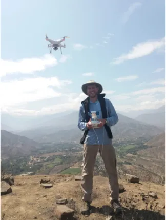
Figure 9. The Author piloting the Phantom 4 drone from the summit of Cerro Cumbray.
Much like fine-scale photogrammetry of artifacts, drone photogrammetry methods benefit
greatly from flat overhead light. The best flight times are thus shortly before and after noon.
Flight opportunities are also limited by the thick coastal fog which often characterizes
mornings in the Moche Valley. Moisture in the air can reach levels which damage cameras and
produce foggy or fuzzy photographs. (Patrick Mullins, personal communication, 2019). As the
Phantom 4 unit used in the survey was both “brand new” and “really expensive” I sought to
avoid exposure to adverse conditions whenever possible (Brian Billman, personal
A total of 489 photographs representing 2.74GB of data were taken over the course of
two days. Agisoft Photoscan was used to align the photos and construct a 3D model of the site.
From this 3d model, Photoscan was used to generate a geolocated orthophoto and DEM from this
3D model in .tif format. These files were imported into QGIS for initial proofing and ArcPro for
more rigorous analysis. The creation of an orthophoto allows for true comparisons between
architectural features because orthophotos present accurate distances. The DEM is used for
viewshed analysis as well as to produce a number of other raster layers. One of the most
productive layers was a hillshade produced from the DEM. The use of artificially enhanced
lighting made visible a number of ditches and several terraces not visible in the original
photographs.
Cerro Cumbray – Survey Results
Located a short walk up the ridge from the Momdern hamlet of Cumbray, Cerro
Cumbray has only one viable approach. Low down, it involves negotiating a steep scree covered
slope and often falling into single file as the ridge narrows and expands. Nevertheless, the east
facing slopes of the low ridge was terraced and prehistorically occupied. While no systematic
survey was conducted lower on the approach due to time constraints, Brian Billman’s 1990–1
field notes and my own observations of surface ceramics would guardedly date the lower
occupation earlier than the LIP.
As the ridgeline steepens and approaches the summit, it again narrows. It was at this
point that we discovered a well-preserved gate. The gate was situated on the most level approach
to the upper site, presumably because it was the easiest everyday access. Small foundations flank
gate immediately between two steep slopes would have made it easy to augment the site’s
natural defenses. Past this gate, the Chimú occupation of the site is readily apparent.
Figures 10 and 11. The Cerro Cumbray Gate from Below and Above. The individual on the right, Robby Valderrama, is 1.6m tall. The author, on the right, is 1.8m tall.
Excluding areas below the entrance gate, the site can be divided into four main sectors.
They are, in order of increasing distance from the south gate: (1) the approach, (2) the summit
area, (3) the bastion, (4) the lower occupation area. The results of pedestrian survey above the
Figure 12. The division of the site into different sectors based on topography and artifact data.
Sector 1 is a relatively narrow section of the ridge, though not quite as narrow as the gate
passage. As it approaches the summit, it becomes broader and less steep. From the samples taken
(022–032), the ceramic density is low at an average of 4.9 sherds/m2. This average is also
artificially rather high, given the inclusion of sherds redeposited from higher ground at PD-028.
This was noted as a flat catchment area below an actively eroding surface and contained 24 total
discovered in Sector 1: one coastal blackware, one coastal redware, and one Salinar. Only one
sherd was large enough to indicate form, representing a blackware jar.
Table 1. Diagnostic sherds from Sector 1.
Sector 1 Diagnostic Sherds
Coastal
Red Coastal Black Highland Salinar Unidentified Total
Jar/Olla 0 1 0 0 0 1
Urn 0 0 0 0 0 0
Plate 0 0 0 0 0 0
Unknown 0 0 0 1 0 1
C-Rim 0 0 0 0 0 0
PdG 1 0 0 0 0 1
Mold/App 0 0 0 0 0 0
Total 1 1 0 1 0 3
No lithic artifacts or ecofacts were documented in this zone. Shortly past the entrance
gate, the remainder of a substantial wall was documented immediately downhill of PD-031.
As the approach flattens near the top of the hill, the transition is both immediate and
remarkable. This marks Sector 2, the summit area. This area is marked by a significantly higher
ceramic density, averaged from PD’s 008–021. The average for this sector is 18.2 sherds/m2.
Twenty nine diagnostic sherds were identified, of which 16 were coastal blackwares, 10 were
coastal redwares, 1 was highland and 2 were unidentified. Of the diagnostic sherds, the majority
of coastal wares were jars/ollas (18) with a small cluster of urns (3). Several pieces of coastal
ware were further identifiable as C rims (1) or Piel de Ganzo (2). The only face motif sherd
found during the survey was a piece of coastal blackware located at PD-019. The single highland
Table 2. Diagnostic Sherds from Sector 2.
The eastern edge of Sector 2 also shows the highest concentration of lithic artifacts
anywhere on the site, seconded by a lighter concentration in the upper area of Sector 4. All of the
lithic artifacts found were a type of fine grained local andesite, characteristic of stone tools in the
Moche Valley.
Evidence of scattered broken marine shell was found at PD’s 009, 012, 020. The only
whole shell observed on the site was located at PD-013 and was identified as Donax Peruvianis.
Sector 2 Diagnostic Sherds
Coastal
Red Coastal Black Highland Salinar Unidentified Total
Jar/Olla 7 11 0 0 0 18
Urn 3 0 0 0 0 3
Plate 0 0 1 0 0 1
Unknown 0 0 0 1 1 2
C-Rim 0 1 0 0 0 1
PdG 0 2 0 0 0 2
Mold/App 0 2 0 0 0 2
Total 10 16 1 1 1 29
Figure 14. Marine shell found at Cerro Cumbray. A value of 0.5 indicates the presence of broken shell, a value of 1 indicates an intact shell.
Sector 3 is located to the west of the Sector 2 down the western ridge. Sector 3 is defined
by the PD’s from 002–007. While not as low as Sector 1, ceramic densities in Sector 3 are
significantly lower than Sector 2. Based on an average of PD’s 002–007 the ceramic density of
Sector 3 is approximately 8.7 sherds/m2. Four diagnostic sherds were found in Sector 3, all
coastal blackware. One was identified as a C rim. While no highland diagnostic sherds were
found, 14 body sherds at PD-006 were noted as possibly highland due to their overall brown
color, the inclusion of lustrous micaceous minerals, and the overall small size of inclusions. Due
to their similarities in temper and surface treatment, these sherds likely originate from a single
Table 3. Diagnostic Sherds from Sector 3.
The most significant area of Sector 3 is the western edge, which represents the most
fortified area of the site. At this boundary, a natural ditch has been enhanced by the construction
of two stone walls (Figure 15). It is unclear whether the ditch was excavated prehistorically to
increase its military function. A prehistoric earthwork lended cover to defenders above without
being a true parapet. There is also evidence of an eroded v-shaped ditch between PD-004 and
005, more visible under hillshade lighting conditions(Figure 16).
Sector 3 Diagnostic Sherds
Coastal
Red Coastal Black Highland Salinar Unidentified Total
Jar/Olla 0 3 0 0 0 3
Urn 0 0 0 0 0 0
Plate 0 0 0 0 0 0
Unknown 0 0 0 0 0 0
C-Rim 0 1 0 0 0 1
PdG 0 0 0 0 0 0
Mold/App 0 0 0 0 0 0
Figure 15. The bastion at the western end of Sector 3 under normal light. Green lines represent the approximate upper and lower bounds of a defensive earthwork,
Figure 16. The bastion at the western end of Sector 3 under hillshading. Green lines represent the approximate upper and lower bounds of a defensive earthwork,
Two of the three slingstones documented at Cerro Cumbray were also found in Sector 3
at PD-002. No other lithic artifacts or ecofacts were found in this sector. The steep ditch west of
PD-002 limited further survey in the interest of safety. By retracing the ridge from Sector 3 back
Sector 4 is defined by a high ceramic density and evidence of significant prehistoric
terracing. PD’s 034–053 define the limits of Sector 4, but it’s likely that PD’s 034-040 represent
either a less dense occupation than the upper areas of Sector 4 or erosion deposits from terraces
higher on the face. As such, a distinction is drawn between the lower and higher areas of Sector 4
in the site map. The average ceramic density between PD’s 034–053 was 16.8 sherds/m2.
Considering only PD’s 41–53 yields an average of 23.8 sherds/m2. 29 diagnostic sherds were
identified:, 13 coastal blackware, 10 coastal redware, three highland, and three unidentified. All
of the coastal wares were identified as jars/ollas apart from two red, coarsely tempered urn
sherds identified at PD-053. Both highland sherds were identified as plates, one a coarse
earthenware (PD-041) and one a painted thin walled vessel (PD-049). Among the more unusual
finds was a small blackware applique hand (PD-048).
Table 4. Diagnostic Sherds from Sector 4.
Sector 4 Coastal
Red Coastal Black Highland Salinar Unidentified Total
Jar/Olla 6 8 0 0 0 14
Urn 2 0 0 0 0 2
Plate 0 0 1 0 0 1
Unknown 1 0 1 0 0 2
C-Rim 0 2 0 0 0 2
PdG 0 1 0 0 0 1
Mold/App 0 2 0 0 2 4
Painted 1 0 1 0 1 3
Total 10 13 3 0 3 29
From the ridge that comprises Sector 4, a number of walls and terraces were visible on
the northeastern slope of the hill above the river valley. Erosion, site degradation, and steep
Cerro Cumbray – Basic Interpretations
Per the ceramic, lithic, and biological evidence, four distinct areas can be identified at the
site corresponding with the four sectors identified above. Sector 1, the approach, has a low
artifact density. As such, it likely represents the entrance path to the site, but little more than that.
Sector 2, the summit area, can be described best as a general work and food preparation
area. The lithic evidence speaks to the use of an open and flat space in the preparation of stone
tools. Food preparation is evidenced by the presence of marine shell including the single
identifiable instance of Donex Peruvianus. The concentration of urns near the summit may also
signal the storage of water in this area. This would be necessary given the site’s lack of internal
water source. During times of conflict, the flat and highly visible nature of this area would also
make it an ideal signaling platform.
Sector 3, the bastion, is largely defensive in nature. While the gate and wall complex near
PD-031 defended the most likely approach, Sector 3 defended the rear. This is evidenced both by
the presence of slingstones and the walls and earthworks by PD-002. The ditch between PD-004
and 005 may represent a backup fortification or fall back defensive line. This is the strongest
evidence for intentional fortification at Cumbray.
Sector 4, with a high ceramic density and a sequence of terraces, likely represents the
site’s main occupational area. Most of the forms present (jars/ollas) are constricted and related to
liquid storage or cooking. The terraces visible from Sector 4 on the northeast face likely
represent additional residential terraces, and would be a promising area for future investigation.
This evidence overall speaks to a site that was situated in a naturally defendable setting
and over time, lightly fortified and sparsely occupied. It was not a fortified military outpost, able
best be interpreted as a refuge site, one that was occupied more during times of conflict, and
more lightly during less tumultuous periods. The use of the site as a periodic refuge would help
explain the large number of storage or constricted cooking vessels present in the diagnostic
dataset. The presence of blackware C Rims date the site to the Middle or Late Chimú phases, a
time of heightened tension between the coast and highlands (Toohey 2016). If ceramics are taken
to reflect the origin of the resident population, the site was overwhelmingly coastal. The presence
of a few highland sherds, though, does speak to a frontier that was at least somewhat porous. The
very limited set of highland diagnostic sherds would seem to indicate that, at Cerro Cumbray,
highland wares were present mostly as serving vessels. However, the limited sample size makes
this little more than conjecture.
In order to truly understand the role that Cumbray played however, its necessary to move
beyond the bounds of the site itself. A more full understanding of the world in which the site’s
Chapter 5: A View to Kill
The advent of widely available and user-friendly GIS software has made viewshed
analysis a popular technique, both in the Andes and further afield. While viewshed techniques
can be adapted to nearly any context, this analysis focuses on surveillance and security. This
trend in Andean archaeology was invigorated by the work of Elizabeth Arkush, who used
intervisibility as a means to examine the role of fortified sites in the Titicaca Basin (Arkush
2011). Patrick Mullins’ 2016 work focuses on the intervisibilty of a number of Moche Valley
LIP fortified sites (Mullins 2017). My paper deals with a similar subject matter, but is instead
focused on the visibility of three hypothetical invasion routes from Cerro Cumbray. Using this
data, the role of Cerro Cumbray in the overall Chimú defensive network can be examined.
GIS Analysis - Selection and Considerations
Five sites are involved in the Viewshed analysis hereafter presented. They are Chan
Chan, Cerro Cumbray, Cerro Ramon, Rogoday, and Guzmango. Each was chosen for a certain
role. Chan Chan, as the Chimú capital, was likely the ultimate goal of Inka conquest. As such, it
represents the destination point of all GIS functions discussed in this chapter. Cerro Cumbray
serves as the center of the viewshed polygons, and the PD’s shown in Figure 8 are used as the
observer points for the visibility analysis conducted here. Guzmango, Cerro Ramon, and
Rogoday serve as three hypothetical starting points for a highland based invasion of Chan Chan.
Three possible invasion routes are modeled using a least-cost path function. The visibility of
each route was then calculated as a percentage of the least-cost path that falls within a viewshed
polygon centered at Cerro Cumbray. In order to account for different weather and light