as route engine providers and the cost to the service users is usually high.
ROUTE BUILDER is a software program that can compile route information from simple operations. It can make use of maps expressed in terms of altitude, latitude and longitude as well as illustration maps, so it is also capable of compiling route information for the insides of buildings. It is also capable of compiling route information for an entire district covering the insides of buildings, by connecting maps made with differ-ent floors, those of differdiffer-ent scales and 3D route information from outdoors to indoors. The compiled route information can thus be shared by using an open format.
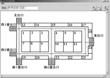
1) ROUTE BUILDER registers route information using maps expressed in terms of altitude, latitude and longitude and illustration maps (Fig. 1). In the figure, “○” (nodes) and “―” (dashes) marked on the center of pathways indicate the routes compiled using the ROUTE BUILDER and the num-bers are the tentatively assigned store numnum-bers.
2) The system can use the maps used in websites and those based on existing guidance maps, thereby making it possible to reduce the costs of preparing the maps to be used as the basis of route information.
The widespread distribution of the Internet and the advance-ment of broadband and ubiquitous computer networks in our daily lives have led to a rise in the need for the provision of mobile equipment positioning information. Meanwhile, the ITS (Intelligent Transport Systems) pedestrian systems need route guidance services that are capable of being able to pro-vide general assistance to the public as well as specific assis-tance for vision and hearing impaired persons.
At present, route guidance services are most advanced in the provision of route information for vehicles, this is as a result of the wide availability of car navigation systems. Route infor-mation provision for pedestrians is also being advanced fol-lowing the development of pedestrian navigation services such as ezNaviWalk.
Although the compilation of route information for route guidance services necessitates maps to be expressed in terms of altitude as well as latitude and longitude data, such maps are not normally prepared for underground shopping centers, sta-tion precincts and specialized shopping malls or for theme parks. So, these facilities have been excluded from the cover-age of existing route guidance services. Even when such maps are prepared for these facilities, they are usually prepared only at the individual facility level because their scope of applica-tion is limited. Furthermore, since the format of route informa-tion is dependent on route engines, the registrainforma-tion of route information is usually performed by specialist companies such
ROUTE BUILDER is a route building program capable of compiling new route information of an entire district covering the insides of buildings by connecting maps of different floors, maps of different scales and 3D route information from outdoors to indoors. It can be used to provide route information for pictorial maps of underground shopping centers or buildings in websites as well as to connect the above route information with other route information including existing types. Its ground level map can use open format “DRM21” as the common data format.
This paper introduces the newly developed route building software ROUTE BUILDER and describes some examples of services in which this software can be used effectively.
MATSUHASHI Masamichi, YAMASHITA Koji, KUBOTA Atsushi, ITO Yusuke, AMEMIYA Hideki
Keywords
positioning information, route guidance, picture map, map, Bluetooth, wireless information tag, tag, cellular phone, WWW
Abstract
1. Introduction
2.1 Features of ROUTE BUILDER
Fig. 1 Route information registration using an illustration map.
3) It allows route information to be registered using the GUI (Graphical User Interface) tool and the XML (eXtensible Markup Language) defined specifically for the ROUTE BUILDER, so registration of route information is possible by persons other than the employees of specialized compa-nies.
4) It supports the route information of DRM (Digital Road Map) standard format 21 (hereinafter abbreviated to “DRM21,”) so that the maintenance of exiting ground route information (vehicle road route information) is possible. 5) It can connect route information using an illustration map and that using the DRM21 format (Fig. 2) into integrated route information. This enables a route guidance service without interruption between the ground level (existing
ser-vices) and an underground mall, etc.
In the following figure, Ⓒ is the connection point.
6) The supported route information exchange methods in-clude the ROUTE BUILDER-dedicated XML (IRML: See next section), DRM21 and G-XML (Geospatial XML).
(1) Route Description Language “IRML (Integration of Route Markup Language)”
・This defines the XML for use in expressing route informa-tion.
・It can describe the addition, correction and deletion of routes.
・It can add routes to the route information in the DRM21 format.
・It can also describe the route information of positions that are hard to be expressed in altitudes, latitudes and longi-tudes such as for underground malls. It can also define connection of this information with DRM21 format route information.
・This is an original standard of the NEC Corporation.
(2) Route Information Registration Support Tool
・This is the GUI tool for use in preparing the IRML. ・It can create route information by the simple operation of
clicking on the map and the provision of ongoing mainte-nance is possible.
・It can also register attribute information, such as barrier-free information.
・It can utilize illustration maps.
(3) User Management Function
・This function manages the area subjected to route compi-lation per mesh and checks the authorities of users. ・It can collect user-created XML files via the Internet and
incorporate them in the route database.
(4) Simplified Route Search Engine
・This searches routes based on the compiled route informa-tion.
・It can search routes by seamlessly connecting the route information expressed using illustration maps and that ex-pressed in DRM21.
2.2 Functions of ROUTE BUILDER
In the above, we described the features and functions of the ROUTE BUILDER. This section will describe the services available to those using it.
Previous route guidance services have not covered the places for which maps expressed in altitude; latitude and longitude are not prepared, such as for underground shopping centers in underground station precincts and specialized shopping malls etc. However, the ROUTE BUILDER makes it possible to pre-pare route information covering such places by using their il-lustration maps, without the help of a specialized company. This allows the route guidance service to be run at a lower cost, by reducing expenses for the preparation of maps and the registration of route information, etc.
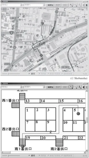
The ROUTE BUILDER can search and give guidance on routes connecting the underground and ground levels as well as simple guidance inside the underground level. For example, when the information on the entrances of the station at the ground level are connected with that on the entrances of the underground mall, the system gives guidance in the form of a map expressed in terms of altitude and longitude while the per-son carrying the system is at the ground level and, when the person comes to an entrance to an underground shopping area, the system is triggered by the signal from the Bluetooth-based wireless information sign “InfoSign1)” map and switches the
information to the guidance using the illustration map for the underground mall (Fig. 3). In this figure, the upper map shows an example of guidance for the route from Tamachi JR Station to the NEC Head Office Building, where Ⓢ is the start point and Ⓒ is the connection point. The lower map shows an ex-ample of guidance from the connection point Ⓒ in the virtual underground mall on the basement of the NEC Head Office Building to the goal point Ⓖ.
Since the ROUTE BUILDER allows anyone who can handle a PC to register route information by the simple GUI operation of clicking on the map, it can be used in applications such as the simulation of a disaster evacuation, in which case it is re-quired to register route information several times in order to verify the evacuation routes.
Fig. 3 Service for guidance of routes connecting the underground and ground level.
3.1 Route Guidance in Underground Malls, etc.
3.2 Route Guidance Connecting Underground and Ground Levels
3.3 Registration of Evacuation Route for Evacuation Simulations
(Ⓒ Shobunsha)
3. Examples of Services Available with ROUTE BUILDER
Golf courses and theme parks are not covered by traditional route guidance services because they do not have the route in-formation registered in ordinary maps. However, the ROUTE BUILDER can give route guidance for such facilities provided that the route information is prepared on the maps owned by these facilities.
We exhibited the ROUTE BUILDER at iEXPO2005 held in December 2005. But this event was simply “for the first time in Japan.” We had in fact already demonstrated the system at the World Congress on ITS held in San Francisco in November 2005 where it had attracted the interest of persons concerned from all over the world. Incidentally, the Autonomous Move-ment Support Project Promotion Committee2) of the Japanese
Ministry of Land, Infrastructures and Transport are actively developing verification trials in order to meet the projectʼs pur-pose of “conducting studies for creating an environment in which “anyone, anywhere and anytime” can access informa-tion on ʻmovement routes,ʼ ʻmeans of trafficʼ and ʻdestinainforma-tionsʼ that is required for participation in or working in the commu-nity.” NEC also contributes to this project by actively partici-pating in the verification trials being held in Kobe by using the simple route compilation capability of the ROUTE BUILDER software.
For the future, we are planning to add an external interfacing function to the route information, and to increase the routing features information that can be registered as well as in devel-oping services and applications that make use of registered route information.
In the above, we introduced the ROUTE BUILDER software that can easily compile route software guidance information based on simplified maps by reducing the map preparation costs, which occupy an important part of the expenses for the systems development program of the Pedestrian ITS.
When this software is used to produce route information that incorporates the information required for assisting the autono-mous movements of pedestrians in local governmental institu-tions, public transport facilities, underground malls and large-scale commercial facilities, it will be possible to build a larger mechanism for the provision of route information by
integrat-5. Conclusion
3.4 Route Guidance for Golf Courses and Theme Parks
4. Future Development
This will make it possible to provide the minimum required information for searching and moving to destinations for vi-sion and hearing impaired persons as well as non-Japanese speaking tourists from abroad. It is expected that, in the future, a variety of convenient systems that effectively utilizes posi-tional information will be required in addition to the route guidance services in order to meet the needs of the broadband-based Ubiquitous society. For our part, we will use the ROUTE BUILDER developed in order to reduce the total systems costs of the Pedestrian ITS in developing various business models for its applications.
In closing, we would like to express our thanks toward the persons who have offered their kind cooperation to us in devel-oping this software.
References
1) ITAGAKI, et al., “Developing Radio Information Beacons to Provide Information to Walkers,” ITS World Congress (Nagoya, 2004), ITS Japan. 2) Autonomous Movement Support Project Promotion Committee: http://www.
jiritsu-project.jp/
*As the products introduced in this paper are mainly sold for the domestic
market, some figures feature explanations by the Japanese Language.
*ROUTE BUILDER is a pending registered trademark of the NEC
Corporation.
*ezNaviWalk is a registered trademark of the KDDI Corporation.
*Bluetooth is a trademark of the Telefonaktiebolaget LM Ericsson, Sweden. *InfoSign is a registered trademark of the NEC Corporation.
*The Pedestrian ITS refers to the ITS destined for “pedestrians, etc.,” which
was positioned as the eighth of the nine development fields for the Intelligent Transportation System proposed by five Japanese (then) ministries and agencies in July 1996.
http://www.mlit.go.jp/road/ITS/j-html/index.html
*The DRM21 is the format used in the roadmap database, which has been
created based on the 1/25000 scale maps of the Geographical Survey Institute and maintained annually based on information from the road managing institutions in Japan including the Regional Development Bureaus, prefectures, cabinet order-designated cities and road-related public corporations.
http://www.drm.jp/index.htm
*The G-XML is a protocol that has been developed in an
industry-university-government collaboration project for use in description communication and exchange of GIS (Geographical Information System) contents in the electronic maps of the XML-compliant format and also for their distribution via the Internet.
MATSUHASHI Masamichi
Expert, ITS Business Development Center, Market Development Division,
NEC Corporation
Member of The Virtual Reality Society of Japan YAMASHITA Koji
Assistant Manager, ITS Business Development Center, Market Development Division,
NEC Corporation KUBOTA Atsushi
Manager, IT Consulting Department, Fourth Systems Division,
NEC Software Chubu, Ltd. ITO Yusuke
Staff, IT Consulting Department, Fourth Systems Division, NEC Software Chubu Ltd.. AMEMIYA Hideki
Senior Manager, ITS Business Development Center, Market Development Division,
NEC Corporation