470
COMPARATIVE STUDY ON THE USE OF GNSS TECHNOLOGY AND
TOTAL STATIONS IN THE GENERAL CADASTRE WORKS IN ROMANIA
BADESCU G.,CALINA A., CALINA J., MILUŢ M., BABUCA N., CROITORU A., BUZATU C.
1
University of Craiova, Faculty of Agronomy
Key words: total station, general cadastre, surveying, GNSS
Abstract:
It presents the use of GNSS technology and total stations in the general cadastre works in Romania and a comparative study between the two methods of measurement, and their use together.
When using total stations and other '' classical '' measurement methods, it is imperative to reduce projection distance before compensating for the measurements and then determining the coordinates.
The widespread use in Romania of measurement methods using GNSS technology and the RTK measurement method, especially the latter for detail points, is beneficial because distance reduction is no longer necessary and generally there are no problems as before when distances are measured with total stations if it is not reduced to the projection plan.
Finally, conclusions are drawn from the use of GNSS technology and total stations separately and together in cadastral elevations for the general cadastre.
Conclusions on the methods of measurement and the study compared to the two methods of measurement are auspicious and should be learned by those working for the implementation of the general cadastre in Romania.
INTRODUCTION
A comparative study on measurements using GNSS technology and total stations in the outskirts of Oncesti Commune, Maramureş County, is presented. The measurement method using GNSS technology is RTK, and with total stations, the classic methods: routing and point surveying. The case study is chosen outside the Onesti Commune, Maramureş County. General cadastre works (systematic cadastre) are performed with the help of new GNSS technologies and total stations, here a comparative study and the conclusions to be drawn from this article.
WORK METOHDS
For the GPS measurements, the following operations were carried out: planning and design of kinematic measurements, making kinematic measurements, processing of kinematic measurements.
In the case of kinematic measurements, some of the principles of static measurements also apply. The fundamental condition to be observed for kinematic measurements is the permanent reception of the signals emitted by at least four satellites (currently received during both stationary and time intervals from one station to another.
471
Measurement planning was done at the office after careful land and satellite reconnaissance, GNSS real-time positioning equipment and post-processing GNSS positioning.
The measurements were completed in the out of town for the introduction of the general cadastre (systematic cadastre).
For measurements in the out of town of Oncesti commune, Maramureş County, measurements were made during the autumn.
-The observation plan for each location was projected at the office based on the information gathered during the land recognition phase and taking into account that 2 GNSS receivers are available to perform the measurements:
- a first design criterion was to cover the required area of interest and to choose the common points for connecting to the reference systems.
-a second criterion was the efficiency during the measurements, in particular optimization of the time between points and between observation sessions.
-a third criterion was staying in at least two independent sessions of each benchmark and establishing at least two links to adjacent points to achieve the required precision and confidence parameters.
The observation plan was compiled on the computer through Ashley's MULTI SITE MISSION PLANNING program. A project called "ONCEŞTI.PRJ" was created that included all the points selected for GPS observations.
The basis of the observation program was:
geographic coordinates and approximate altitudes of points, extracted from map sheets 1:25 000 (or already known);
Recognition sheets prepared during the land recognition operation for the points which ensured for the entire horizon an open window above the elevation of 15 °.
Planning has been done for the present example for three receivers so that the following conditions are met:
at least 6-9 satellites received at the same time by the three receivers;
The PDOP value, as a measure of expected accuracy and imposed by the satellite constellation geometry, is below 5;
Minimum observation time between 10-20 seconds and up to 1 minute; In the Onceşti commune in Maramureş County, kinematic measurement method was used to determine the coordinates of the detailed cadastral points, the coordinates were determined in real time, using two HITARGHET type GNSS receivers. These receivers or used for real-time measurement, the transcalk coefficients in the WGS-84 system were introduced in the Stereo 70 system so that the coordinates were determined directly in the field in the national projection Stereo 70 (TransDAT Program).
This was possible by using a type controller that is very convenient and easy to handle.
During the measurements, it was intended to receive at least five satellites, as the interruption of signals from a satellite can occur and thus the reception of at least 4 satellites is sufficient to determine the coordinates. Even if during a measurement session the constellation changes, the measurements will not be compromised. It is not necessary to receive signals from the same satellites from the beginning and until the end of the measurements.
For cinematic measurements, it is very important to choose the correct path to ensure that the signals are received permanently. At any time and at any point of the route, at least four satellites must be visible. This assumed that before the measurements begin, the proposed route will be traced and identified the obstacles that could prevent the reception of satellite signals in good condition.
472
For the points on the boundaries of the sectors or property bodies (in the areas of coverage), or high "eccentric" auxiliary points on the line from which the distance to the point to be raised was measured with the roulette.
For permanent constructions, the antenna is also placed in "auxiliary points" (eccentric), on the façade line (in extension), each time measuring the roulette distance to the points of the building.
The buildings with stairs were taken from their corners and a corner of the building (directly or as an auxiliary point).
For lifting the cadastral details of the property, there were raised points belonging to permanent elements, accessible by the type of the manholes, the corners of concrete fences etc., which can then be used to lift the other details by intersections of distances.
In order to make comparisons, the selected areas were also raised with the total stations using the known classical methods.
Throughout the measurements, much attention has been paid to:
pressing the ROVE key before the antenna moves to another point;
Handling the antenna in such a way as to avoid losing signals from the satellites at any of these times;
placing hands under the flat surface of the antennas during their handling. RTK method.
The real-time kinematic measurement method (RTK) was used for detailed cadastral elevations in the outskirts of Oncesti Commune, Maramureş County.
And in these cases, the observation plan was projected at the office using elements and respecting the same known criteria and conditions.
At the end of the daily observation session, recorded data is downloaded from the internal memory of the GPS receiver to a computer and DVDs. Downloading data is through a program included in the GPS software.
For land recognition, 1: 25,000 scale maps were used to identify triangulation points in the area.
The processing of GPS measurements has been made taking into account the known formulas. At the end of the daily observation session, the recorded data was downloaded from the internal memory of the GPS receiver to a computer and floppy disks. Downloading data is through a program included in the GPS software.
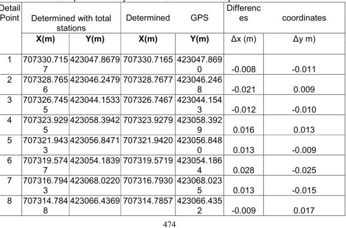
From the point of view of precision, the results are presented in the tables and from a careful visualization it can be seen that the accuracy of the measurements using the GNSS technology is superior to the one made with the total stations, with the accuracy of the GNSS technology being uniform.
In the tables are presented the coordinates in the Stereo 70 projection system, determined by classical RTG, with the corresponding values and the comparative study tables for: Onceşti out-of-town, Maramureş County.
RESULTS AND DISCUSSIONS
To carry out a comparative study, the areas of Oncesti commune, Maramureş County, were also raised with the total stations.
On the outskirts of Oncesti commune, Maramureş County, the operations were as follows:
473
channels, fences, etc., were identified, and then the parcels included in the land plots were identified according to the parcel plan; and also measured.
In the out of town, the landings are identified and measured beforehand, and then the parcels that compose it are identified and measured. The surface of the landing must be the same as the sum of the plots of the parcels that make up it.
Dredging points were determined and the cadastral lifting points were radiated from them. The number of stations was 54, which was influenced by the concrete conditions on the ground, the lack of visibility between the stations, as well as between the stations and the points of cadastral lifting.
The area measured was about 650 ha and was composed of 12 land plots, which were cultivated with corn, alfalfa and fruit trees.
The time required for cadastral lifting with the total station amounted to 2,1 days, time for a team of three people.
In Oncesti commune, Maramureş County, the measurements using the total stations were carried out by a team of three people using a total Sokia station, two canes with 2 reflectors, a Suzuky land car.
It should also be mentioned here that the methodology for collecting the details, for the purpose of drawing up the cadastral plan, requires the drawing up of sketches and the attribution of codes characteristic of the types of details.
To compare the time required for lifting by each method, the relationship was used: T = T1 + T2 + T3, where
T1 - it is the cumulative time at the office to carry out the lifting project as roughly 60 minutes for each method;
T3 - it is the time to process the measured data that is estimated at 0 minutes for GNSS elevations, because it is determined in real time and about one day for the total stations.
T2 - is the time required to raise the approximate detail points with the relation: For the GNSS kinematic method:
t m t n t t t T i i 4 3 5 2 1 2 2 5 -10 min. - selecting the location of the reference station (if the station is the value of the station is several tens of seconds);
10-15 min. - initialization of the reference station and the communication system (if the station is the value is several tens of seconds);
5 sec. - 1 min. - measuring in detail;
1 min. - processing detail point observations (zero for being instantly determined);
10 min. - tightening the reference station (if it is a parking station the value is several tens of seconds);
n = the total number of points of detail; m = number of mobile handsets;
For the GNSS method, the time is 10-30 seconds for a point of detail and for the whole area we have: 10-30 seconds min x no. points:
For the case of cadastral measurements on the outskirts of Oncesti locality in Maramureş County we have: 30 seconds x 1441 points = 43230 seconds / 3600 12 hours 1/2 days
For lifting stations with total station results:
- Performing observations for a point of detail in
which:
10-30 min. - recognition of the land and the point;
10-20 min. - Staging at the station station including installation of the instrument;
474
1 min. - aiming and measuring to the point of detail; 1 min. - processing comments for the point of detail;
10 min. - tightening the instrument and moving it to another station; n = the total number of points of detail; m = number of reflectors;
For the case of cadastral measurements on the outskirts of Onceşti locality in Maramureş County we have:
2 min x 1441 points + [(t1 + t2) + t5] = 176520 seconds / 3600 49 hours 2,1 days
From the above, the following conclusions can be drawn:
Its value is lower for metric measurements kinematic GPS, but this value is calculated if the measured points are determined from a station. This was done by the GNSS technology by the real-time kinematic method (RTK), and the time required to determine the 1441 points in the Onceşti locality outside of Maramureş County was half a day for a team of three people.
At the measurements in Onesti commune in Maramureş County, over 650 ha of the total area of the commune were measured. Percentage of the surface is presented in annexes.
Measurements in the out-of-town area, in this case Oncesti commune in Maramureş County, using GNSS technology, were performed 100% in terms of cadastral details in the concrete conditions in the field. The cadastral details of the out of town were totally lifted because the field conditions were better than in the city, with no obstructions to the satellite signals.
In our case, the receivers used were two-wave geodetic class, resulting in much greater efficiency in cadastral elevations. Simple frequency receivers can also be used, but they have more stringent limitations than L1, L2.
The measurement process can be improved by using GNNS receivers that are also receiving the NAVSTAR-GPS satellites and GLONASS or satellite satellites of the GALILEO European system at least between 9-16 visible satellites, which is very good for cadastral measurements, here it takes at least 5 satellites.
Table 1 Comparative study common coordinate Onceşti from Maramures – Outside Detail
Point Determined with total stations
Determined GPS
Differenc
es coordinates
X(m) Y(m) X(m) Y(m) Δx (m) Δy m)
1 707330.715 7
423047.8679 707330.7165 423047.869
0 -0.008 -0.011 2 707328.765
6
423046.2479 707328.7677 423046.246
8 -0.021 0.009 3 707326.745
5
423044.1533 707326.7467 423044.154
3 -0.012 -0.010 4 707323.929
5
423058.3942 707323.9279 423058.392
9 0.016 0.013 5 707321.943
3
423056.8471 707321.9420 423056.848
0 0.013 -0.009 6 707319.574
7
423054.1839 707319.5719 423054.186
4 0.028 -0.025 7 707316.794
3
423068.0220 707316.7930 423068.023
5 0.013 -0.015 8 707314.784
8
423066.4369 707314.7857 423066.435
475 9 707310.936
0
423063.3232 707310.9374 423063.324
7 -0.014 -0.015 10 707303.848
7
423089.8111 707303.8469 423089.813
3 0.018 -0.022 11 707301.389
9
423088.0592 707301.3877 423088.057
2 -0.021 0.022 12 707295.812
4
423082.2670 707295.8142 423082.269
5 -0.018 -0.025 13 707274.615
9
423063.3478 707274.6139 423063.349
4 0.020 -0.016
CONCLUSIONS
Following the results of the case study, the following conclusions and recommendations can be made:
The most accurate GPS methods in terms of accuracy and speed for building cadastral details are Real Time Cinema Method (RTK).
The use of the network of permanent stations (which take the role of fixed stations), bring great advantages in increasing the accuracy of lifting, reducing the cost price, the labor force and the working time in the field.
It is recommended to use at least two mobile receivers for very high field efficiency.
In order to increase the accuracy of high point determination, it is recommended to determine two vectors from each point of detail, preferably by scanning the points with a mobile handset at one end of the area, and with the second mobile handset at the other end of the area, each point is staked twice to obtain independent vectors and eliminating any errors associated with the mobile handset.
all kinematic measurements must be initialized in time during their performance. There are several possibilities for initialization: By permuting the antennas, by measuring a known base, the OTF (On The Fly) process, the latter being used for the RTK measurement method.
It is also recommended to reset the mobile handsets at the end of the kinematic measurements in order to have a safety, if initialization from the beginning is not OK.
The use of GPS’s combined with total stations does not have restrictions of use regardless of the type of area, and the yield increases both in terms of precision and cost.
The comparative study on the use of GPS and total stations in cadastral elevations recommends GPS methods both in terms of precision and efficiency, with a ratio of about 4/1 in favor of them.
The use of GNSS technology in cadastral elevations using NAVSTAR-GPS satellites and GLONASS or GALILEO satellites, as the number of visible satellites in a station would increase to 9-20, increasing safety, precision and lift performance.
BIBLIOGRAPHY
476
2.Badescu, G; Stefan Ovidiu; Radulescu, GM - Using Satellite Methods, GNSS ROMPOS in Developing the Control and Survey Network of LIPOVA Forestry Buildings, UPV BELOTINT, ARAD County, Proceedings of the 2nd WSEAS International Conference on Engineering Mechanics, Structures and Engineering Geology (EMESEG '09), Rhodes GREECE, 22-24 Jul. 2009, Book Series: Mathematics and Computers in Science and Engineering, Pag. 262-267.
3. Badescu, G ; Badescu, R; Stefan, Ovidiu ; Ortelecan, M ; Pop, N ; Ciotlaus, A; Luput, L - 2011- Using GPS-GNSS global positioning systems in agriculture, Conference: International Conference on Agricultural and Biosystems Engineering, 20-21 FEB 2011, Hong Kong, CHINA, Book Series: Advances in Biomedical Engineering, Pag. 449-452. 4. Badescu, G ; Badescu, R ; Stefan, Ovidiu; Didulescu, C ; Veres, IS ; Paunescu, C - Studies and research on the use of Virtual Reference Station (VRS) and Precise Point Positioning (PPP) GPS in Romania, International Conference on Mechanical, Industrial, and Manufacturing Engineering (MIME 2011), JAN 15-16, 2011, Melbourne, Australia, Book Series: Lecture Notes in Information Technology, Pag. 414-417, ISBN: 978-0-9831693-1-4.
5. Badescu, R; Badescu, G; Stefan, Ovidiu; Didulescu, C; Badea, G; Badea, AC - Positioning System GPS and RTK VRS type, using the Internet as a base, a network of multiple stations, International Conference on Mechanical, Industrial, and Manufacturing Engineering (MIME 2011), JAN 15-16, 2011, Melbourne, Australia, Book Series: Lecture Notes in Information Technology, Pag. 548-551, ISBN: 978-0-9831693-1-4.
6. Badescu, Gabriel; Stefan, Ovidiu; Badescu, Rodica; Darja, Marcel; Ortelecan, Mircea; Pop, Nicolae Veres, Ioel Samuel - The Use of GIS is Shown in Taking Decisions Regarding on Environmental Engineering Projects, 12h International Multidisciplinary Scientific Geoconference (SGEM), SGEM 2012, VOL. III, Albena, BULGARIA, JUN 17-23, 2012, pages 425-432,
7. Gabriel Badescu, Ovidiu Stefan, Marcel Darja, Mircea Ortelecan, Rodica Badescu - Aspects Regarding the use of GNSS technology in local networks in Romania and comparative study with the use of the Romanian Position Determination System (ROMPOS), Proceedings of the 12th International Multidisciplinary Scientific Geoconference - SGEM 2012, 17-23 jun 2012, Albena, Bulgaria, Section Geodesy and Mine Surveying, vol II, pag. 685-692, ISSN 1314- 2704.
8.Călina Aurel, Călina Jenica, Miluț Marius, Croitoru Alin, Ionică Cristian, Study on preparation of technical documentation required to design road DC36 upgrading -Stanesti-Stoilesti, Valcea County, Annals of the University of Craiova, Series Agriculture, Montanology, Cadastre, Vol. XLIV/2, Ed. Universitaria, Craiova, pag. 35-41, ISSN 1841- 8317, http://anale.agro-craiova.ro/index.php/aamc/article/view/165/159, 2014.
9. Georgi M, Keranka V, GNSS and Gravity Projects in Europe and Bulgarian Participation FIG Working Week, 2003, Paris, France, April 13-17, 2003;
10.Miluț M., Călina Jenica, Croitoru A., Buzatu C., Iosif G. - Leica SR20 GPS receiver use and data processing for topographical surveying in order to rehabilitate a communal road, Annals of the University of Craiova, Series Agriculture, Montanology, Cadastre, vol XLI/2, Ed. Universitaria, Craiova, pag. 373-380, ISSN 1841-8317,
http://old.agro-craiova.ro/index.php/aamc/article/view/632/584, 2011.
11.Neuner J., Global Positioning Systems (Sisteme de poziţionare globală), 2000, Matrix Rom Publishing House;