Approach and Methodology i
TABLE OF CONTENTS
3
APPROACH AND METHODOLOGY ... 3-1
3.1
Introduction ... 3-1
3.2
ESIA Process... 3-1
3.3
Stakeholder Consultation and Disclosure ... 3-3
3.3.1 Overview ... 3-3 3.3.2 Stakeholder Identification ... 3-4 3.3.3 Tracking Consultation... 3-53.4
Screening Phase... 3-5
3.5
Scoping Phase... 3-6
3.6
Project Development and Evaluation of Alternatives ... 3-6
3.7
Legislative Review ... 3-7
3.8
Establishing Baseline Information ... 3-7
3.9
Impact Assessment Methodology ... 3-8
3.9.1 Identification of Impacts... 3-8 3.9.2 Mitigation of Potential Impacts... 3-10 3.9.3 Residual Impacts and Defining Significance ... 3-11 3.9.4 Importance/Sensitivity of the Receptor... 3-12 3.9.5 Magnitude of Potential Impact... 3-12 3.9.6 Impact Significance Assessment Tables ... 3-12 3.9.7 Evaluating Significance of Residual Impact... 3-423.10
Environmental and Social Hazard and Risk Assessment ... 3-42
3.11
Cumulative and Transboundary Impacts ... 3-43
3.12
ESIA Disclosure and Regulatory Approval Process... 3-44
3.13
Management and Monitoring ... 3-45
3.14
Difficulties Encountered ... 3-45
3.15
Lessons Learned ... 3-46
Tables
Table 3-1: Issues–Receptors–Impacts Example ... 3-9
Table 3-2: Receptor Importance/Sensitivity and Magnitude Topics ... 3-13
Table 3-3: Importance/Sensitivity of Receptors to Impacts on Soils and Ground
Conditions ...3-13
Table 3-4: Ranking of Magnitude of Predicted Impacts on Soils and Ground
Conditions ...3-14
Table 3-5: Importance/Sensitivity of Visual Receptors and Landscapes ... 3-15
Table 3-6: Ranking of Magnitude of Assessed Impacts on Visual Receptors and
Landscape Character... 3-16
Table 3-7: Importance/Sensitivity of Surface Water Resources and Users ... 3-18
Table 3-8: Ranking of Magnitude of Predicted Impacts on Surface Water ... 3-19
Table 3-9: Importance/Sensitivity of Groundwater Resources and Users ... 3-21
Table 3-10: Ranking of Magnitude of Predicted Impacts on Groundwater ... 3-22
Table 3-11: Importance/Sensitivity of Ecological Receptors... 3-23
Table 3-12: Ranking of Magnitude of Predicted Ecological Impacts ... 3-25
Table 3-13: Importance/Sensitivity of Receptors for Air Emissions ... 3-27
Approach and Methodology ii
Table 3-14: Ranking of Magnitude of Impacts of Emissions to Air ... 3-28
Table 3-15: Importance/Sensitivity of Noise Receptors... 3-29
Table 3-16: Ranking of Magnitude of Noise Emissions ... 3-29
Table 3-17: Importance/Sensitivity of Receptors for Vibration... 3-31
Table 3-18: Ranking of Magnitude of Predicted Impacts from Vibration ... 3-31
Table 3-19: Importance/Sensitivity of Cultural Heritage Assets... 3-32
Table 3-20: Ranking of Magnitude of Predicted Impacts on Cultural Heritage Assets
... 3-33
Table 3-21: Importance/Sensitivity of Social Receptors ... 3-34
Table 3-22: Ranking of Magnitude of Impacts of Land Acquisition... 3-36
Table 3-23: Ranking of Magnitude of Impacts on Economy, Employment, Skills and
Livelihoods ... 3-36
Table 3-24: Ranking of Magnitude of Impacts on Infrastructure and Services ... 3-38
Table 3-25: Environmental Health Areas... 3-38
Table 3-26: Health Impact Severity Classification ... 3-39
Table 3-27: Importance/Sensitivity of Receptors for Project Traffic and Transport3-40
Table 3-28: Ranking of Magnitude of Predicted Impacts of Traffic and Transport. 3-40
Figures
Figure 3-1: The ESIA Process... 3-2
Figure 3-2: Consultation and Disclosure Process ... 3-4
Figure 3-3: Residual Impact Significance Matrix ... 3-42
Figure 3-4: Residual Risk Significance Matrix for Unplanned Events... 3-43
Approach and Methodology 3-1
3 APPROACH
AND
METHODOLOGY
3.1 Introduction
This chapter describes the process undertaken to produce this Environmental and Social Impact Assessment (ESIA) and presents the methodology used to assess the significance of impacts that may result from the South Caucasus Pipeline Expansion (SCPX) Project. Potential impacts have been identified through baseline assessments carried out in specific relation to the works activities anticipated in this Project and experience gained during the Western Route Export Pipeline (WREP), Baku–Tbilisi–Ceyhan (BTC) pipeline and South Caucasus Pipeline (SCP) construction and operation in Azerbaijan. At the outset of this Project, it was decided that a more contemporary approach to the impact assessment process was needed than was originally defined in the SCP ESIA (2002). Impact assessment methodology has evolved significantly since 2002 and the methodology used to assess the impacts from the SCPX Project will adopt widely established current industry standards and practice.
The methodology takes account of potential impacts on a wide range of receptors including:
The physical and chemical environment (e.g. climate, air quality, soil and groundwater quality)
The biological environment (e.g. plants, terrestrial animals, birds and their food chains)
Communities, social groups and individuals (e.g. employment generation, changes in per capita incomes, threats to vulnerable groups and exposure to health and safety risks).
The results of the impact assessment, assignment of mitigation measures and discussion of key impacts are presented in Chapter 10, Environmental and Social Impacts and Mitigations (Planned Events); Chapter 11, Cumulative and Transboundary Impacts; Chapter 12, Hazard Analysis and Risk Assessment (Unplanned Events); and Appendix B. Impact Assessment and Mitigation Tables.
3.2 ESIA
Process
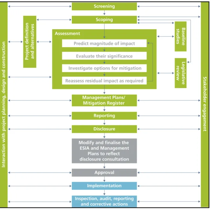
The principles of ESIA are now widely established. Figure 3-1 illustrates several key steps in the general approach.
All major projects will cause some changes to the environment. In the past the ESIA process mainly identified what these changes would be and, after proposing mitigation, reported them to the decision maker. As ESIA has evolved, the emphasis has moved on to the reduction of potential adverse impacts and maximising potential benefits through appropriate design measures. Designing out the significant effects of a project is the central tenet of the approach.
As can be seen from Figure 3-1 an iterative assessment process is shown in the central box of the diagram. The aim of the process is to design out or minimise potential impacts and to do so in a way that prioritises those that are potentially most significant.
The assessment process constitutes a systematic approach to the evaluation of the proposed Project in the context of the natural, regulatory and socio-economic environments in which development is proposed. Each of the steps in the ESIA process will be described in turn in the following sections. However, key to understanding the process applied to minimising the impact of this Project has been the iterative development of mitigation
Approach and Methodology 3-2
measures. All of the potential impacts arising from this Project have been identified, and either standard, recognised industry practice mitigation measures or impact-specific, feasible and cost-effective mitigation measures have been applied. Any potential impacts that remain after the application of mitigation measures are referred to as residual impacts. All residual environmental and social impacts are assigned a level of impact of low, medium, high or beneficial, following the methodology described in Section 3.9.3.
Figure 3-1: The ESIA Process
This ESIA addresses the environmental and social issues associated with the proposed SCPX Project and supplements earlier environmental studies undertaken by BP. It does not seek to repeat information contained in other reports that have been submitted previously to the Ministry of Ecology and Natural Resources (MENR). The SCPX ESIA process has referred to the SCP ESIA (2002) and BTC ESIA (2002) but has followed the standard key steps to produce an ESIA for a new development project, as illustrated in Figure 3-1 and described in the following sections.
Approach and Methodology 3-3
3.3
Stakeholder Consultation and Disclosure
3.3.1
Overview
The process of stakeholder consultation and disclosure is an ongoing overarching requirement that applies to the entire ESIA process. The SCP HGA includes specific requirements for the disclosure (including the time period) of the ESIA. Disclosure is also a requirement of Azerbaijani EIA legislation (as described in the Handbook for the Environmental Impact Assessment Process in Azerbaijan, 1996, and enforced through other legislative processes such as the Law on Protection of the Environment 1999) and is considered good international gas pipeline industry practice. Consultation is of critical importance in gaining insights into the key environmental and social issues, addressing the concerns of communities and other stakeholders, and aiding the development of potential strategies for tackling Project impacts. BP recognises the importance of stakeholder consultation, participation and disclosure during the lifetime of the Project.
Effective consultation with stakeholders is:
Key to understanding the concerns of affected communities and other stakeholders
Achieved by effective disclosure, through the release of timely, accurate and comprehensive information to stakeholders. This is essential to ensure that the likely impacts (both positive and negative) are understood by stakeholders, and that they can provide feedback to the Project.
Stakeholder consultation has the following objectives:
Inform: Provide accurate, relevant, timely and culturally appropriate information to Project stakeholders about the SCPX Project, its impacts and benefits, and the ESIA process. The Project’s stakeholders include host governments, regulatory authorities and Project-affected communities (and are listed in Chapter 9 (Consultation Process) and Appendix C (Public Consultation and Disclosure Plan)
Engage: Provide opportunities for Project stakeholders to express their opinions and concerns about the Project, and to seek broad stakeholder support for the Project and impact management
Understand: Enable the SCPX Project team to understand the concerns and priorities of stakeholders
Review: Incorporate justified concerns and priorities into the design, construction and operation of the SCPX Project
Inform (feedback): Provide feedback to Project stakeholders and host communities as the Project develops so that the consultation process continues.
Approach and Methodology 3-4
Figure 3-2: Consultation and Disclosure Process
Methodologies for consultation and disclosure are discussed in more detail in the following Chapters of this ESIA:
Chapter 8, Socio-economic Baseline, which outlines social and economic issues raised by stakeholders during the consultation process
Chapter 9, Consultation Process, which details the results of consultation undertaken during the scoping/early ESIA stage of the SCPX Project
Appendix C, the Public Consultation and Disclosure Plan (PCDP), which includes further information on the methodology used for data collection, consultation and lists of stakeholders consulted at each point.
The consultation and disclosure process is important and complex and care has been taken to capture and document stakeholder concerns. Care has also been taken to co-ordinate with the considerable amount of work that has already been initiated by BP with the stakeholder groups in Azerbaijan. Specific meetings were held with governmental stakeholders at an early stage in the Project and with non-governmental organisations (NGOs) and the scientific community. In addition to this, specific community consultations were undertaken within Project-Affected Communities (PACs). PACs have been defined for this Project as communities within 2km of the pipeline (including block valves and pigging stations) and pipe storage areas, 5km from construction camps and 300m from access roads.
3.3.2
Stakeholder Identification
BP and the ESIA consultants worked together to identify the key stakeholders to be consulted as part of the SCPX Project. This was done using a combination of previous experience during construction and ongoing operation of SCP, knowledge of Azerbaijan and the local communities around SCP, and consultation with authorities, academics, etc. This has sought to ensure that all the people who may be affected by or have an interest in the proposed Project have had an opportunity to obtain information about the Project and to express their opinions and concerns.
Stakeholders were drawn from the following groups:
Authorities comprising national, regional and local government bodies, of primary political importance to the Project and to the ESIA process
National and regional NGOs, and international NGOs with a presence in Baku
Scientific community
Residents, community leaders, vulnerable groups and land users in the towns and villages in the PACs, i.e. those within 2km of the pipeline (including block valves
Approach and Methodology 3-5
and pigging stations) and pipe storage areas, 5km from construction camps and 300m from access roads.
A full list of the stakeholders consulted can be found in Chapter 9, Consultation Process and the PCDP (Appendix C).
3.3.3
Tracking Consultation
Documentation of public consultation is important to ensure that inputs are captured and fed into the Project planning process and to maintain a record of issues raised by consultees. Minutes were taken for all meetings that include the date of the meeting, material issues raised, people involved and agreed actions. The results of consultation activities are recorded in a stakeholder database. Agreed actions related to mitigation of identified potential impacts will be considered and as appropriate transferred into the Project commitments register (discussed in Chapter 13, Management and Monitoring). An outline of the results of consultations carried out to date is presented in Chapter 9, Consultation Process.
3.4 Screening
Phase
Screening is undertaken at the very early stages of project concept development to identify potentially significant impacts. Early identification of these potential impacts enables projects to gain an early understanding of the key environmental and social sensitivities, and the potential project impacts on those sensitivities. It results in a list of prioritised potential impacts that are likely to require management throughout the life of a project and through to operations. The output from screening informs the scoping of the impact assessment (Section 3.5).
The early nature of screening usually means that precise quantitative data may be unavailable or imperfect. However, as the SCPX Project is located in an area where significant environmental and social baseline data is already available (from previous WREP, SCP and BTC EIAs, operational data and environmental and social monitoring), the screening output was considered fairly robust and representative.
Screening was undertaken for the SCPX Project in line with the requirements of BP’s Environmental and Social Group Defined Practice (E&S GDP). The screening workshop was carried out by environmental and social specialists combining representatives from the Project and the Georgian and Azerbaijan operations environmental and social team. The screening study assessed 25 key environmental and social indicators against Project activities (construction and operation), ranking each potential impact from low to high. The output from the screening process indicated the following potential impacts as some of the key areas for the ESIA scoping to focus on primarily in the construction phase:
Employment and economic opportunity
Cultural heritage
Community safety and disturbance
Infrastructure quality
Community health
Economic resettlement
Protected areas
Protected or endangered species
Environmentally sensitive areas (some of the rivers crossed)
Approach and Methodology 3-6
3.5 Scoping
Phase
An important initial stage in the ESIA process is the scoping of key issues. An ESIA is a multidisciplinary study and its success in connection with any given project depends largely on the ability to identify at an early stage the key environmental and socio-economic issues that should be focused upon. Scoping is the process of determining which issues are likely to be important, including the identification of key environmental and social issues and defining the ESIA terms of reference (ToR). Scoping has identified some or all of the matters to be addressed in the ESIA, including, but not limited to:
Identifying the impacts to be assessed, especially focusing on those that are critical to decision-making by the Project proponents, stakeholders and regulatory authorities
Assessing the types of alternatives to be examined including routing, design solutions and mitigation Baseline aspects that require particular attention.
Since the SCPX Project is an expansion of an existing operational pipeline, where baseline environmental and social conditions are largely understood, part of the scoping exercise was to consider whether any significant gaps were present in the existing baseline data and to focus on filling the gaps with primary baseline data where necessary.
An integral and essential component of the scoping process is stakeholder consultation, which has been carried out in specific connection with the Project (summarised in Chapter 9, the Consultation Process and Appendix C). Consultation has been undertaken throughout the ESIA process, and was not a discrete phase of the ESIA. BP has an ongoing stakeholder engagement programme in Azerbaijan in connection with existing SCP, BTC and WREP operations, and stakeholder consultation for SCPX was carried out both as an extension of this programme and as specific community consultation within the PACs. Consultation with key governmental stakeholders was initiated early in the ESIA process, with NGO, scientific community and consultation with the PACs following later. Information and feedback provided by stakeholders was used to inform the scope of the ESIA.
Consultations between various Project teams were also carried out to maximise the use of information and knowledge gained from previous projects undertaken in Azerbaijan.
Meetings were held with stakeholders on an ongoing basis through the ESIA process in order to inform the ESIA and identify key issues. These will continue throughout the design, construction and operation of the SCPX Project as described in Chapter 9.
Although the description of the scoping process provided above has been described, by necessity, as a discrete step in the ESIA process, scoping in application is actually an ongoing and iterative activity. The use of scoping as a dynamic and evolving tool has enabled the ESIA process to respond to new information, changed emphasis, or Project modification arising from the baseline data collection, consultation and design processes.
3.6
Project Development and Evaluation of Alternatives
Prior to agreeing the SCPX Pipeline route, length, diameter and other aspects of Project design, viable alternatives were identified so that a realistic base-case design could be developed. However, design development is an iterative process and the design is modified continuously to take account of new information as and when it becomes available, including information from the ESIA process.
As new information becomes available the status of potential impacts is continually reviewed and updated. This iterative stage assists in reducing the overall potential impacts of the Project. To facilitate this, the ESIA team worked closely with the design engineers and with ESIA personnel based in engineering offices.
Approach and Methodology 3-7
A full discussion of the alternative options that were assessed during the Project development is provided in Chapter 4, including the social and environmental implications of a ‘no development option’.
3.7
Legislative Review
The legal, policy and administrative framework review for this Project is described in Chapter 6. This review addresses social and environmental requirements and policies relevant to the SCPX Project at the following levels:
SCP host government agreement (HGA) including
o Good international gas pipeline industry standards and practices
o World Bank and other international standards, such as World Health Organization standards
International and regional conventions that Azerbaijan has ratified, acceded to or is a signatory (see Chapter 6)
BP policy and management systems.
Understanding the legal and policy framework ensures that the SCPX Project has been assessed, as far as possible, against relevant existing environmental and social regulations and guidelines as well as BP’s environmental, social, ethical and business policies and standards.
3.8
Establishing Baseline Information
The scoping exercise for the SCPX Project involved a review of available environmental and socio-economic data sources to identify gaps in baseline information necessary to complete the ESIA process. The original SCP and BTC Project ESIAs (2002), and existing SCP and BTC operations’ monitoring results to date, all of which contain valuable baseline information, were reviewed. This gap-analysis approach allowed the Project to avoid repetition of work already undertaken and maximise the collection of focused, up-to-date baseline data from the Project area.
The results of the scoping study indicated that there were certain key issues requiring additional study for the SCPX Project, and that some of the existing baseline data for the Project were either insufficient, out of date (the original SCP ESIA baseline data was collected in 2001) and required supplementary information. The detailed baseline surveys therefore conducted for the SCPX ESIA were:
Botanical and zoological survey of the proposed pipeline route and pigging station location, and a representative sample of the river crossings, focussing on locations where the SCPX route deviates from BTC/SCP and where specific gaps in the original baseline data have been identified
Fish surveys of a representative sample of the rivers that the SCPX route will cross
Cultural heritage survey focussing on re-routed sections, block valve sites, the pigging station, construction camps and pipe storage areas and areas where unexpected finds were discovered during construction
Land contamination survey of pipeline route, block valve and pigging station sites construction camps and pipe storage areas
Soil survey of pipeline route, block valve sites, the pigging station, construction camps and pipe storage areas
Socio-economic survey including gathering of:
Approach and Methodology 3-8
o baseline data for existing health issues and conditions within PACs
o information regarding the use of land by households in the PACs
Traffic surveys at key points along access roads
Project-specific community consultation
Geohazards including soil erosion susceptibility classification
Surface water quality including sampling at significant watercourse crossings
Landscape and visual survey where the SCPX route deviates significantly from the BTC/SCP route
Topographic survey.
Baseline SCP information (e.g. from biorestoration and landscape and visual surveys undertaken from 2007 to 2011) were supplemented with SCPX fieldwork using a combination of local and international scientists.
Summaries of the environment and social baseline report for the physical environment, biological environment and cultural heritage are provided in Chapter 7 and for socio-economic conditions in Chapter 8. More detailed reports on certain baseline studies are contained within the Environment and Social Baseline Report (ESBR) for this Project, namely geology, geomorphology and geohazards, soils and ground conditions, landscape and visual, surface water, groundwater, ecology, climate and air quality, noise, cultural heritage, traffic and socio-economic and health conditions.
3.9
Impact Assessment Methodology
The impact of the SCPX Project on the physical, biological and socio-economic environment has been assessed using the methodology described in the following section. As noted in Section 3.1, it was decided that a more contemporary approach to the impact assessment process would be used than was originally defined in the SCP ESIA (2002).
To maximise the transparency of the ESIA, criteria for assessing the significance of impacts are defined for each issue and type of impact in this section. These criteria take into account whether the project is expected to:
Cause project standards to be exceeded, e.g. air, water or soil quality, noise levels, or make a substantial contribution to the likelihood of exceedance
Adversely affect protected areas or features, or valuable resources: nature conservation areas, rare or protected species, protected landscapes, historic features, livelihoods, important sources of water supply and other key ecosystem services (i.e. the benefits people gain from ecosystems)
Conflict with established company policy/practice.
3.9.1
Identification of Impacts
The impact assessment process initially involves identification of the Project’s activities and potential environmental and social impacts resulting from each activity during the Project phases. A Project activity could include site preparation, construction, reinstatement, operation and decommissioning. It would also encompass planned routine activities; planned, but non-routine activities; and unplanned or accidental events.
Within this ESIA, an impact is defined as ‘Any change to the physical, biological or social environment, whether adverse or beneficial, wholly or partially resulting from an organisation’s activities, products or services’. An impact may result from any or all Project activities.
Approach and Methodology 3-9
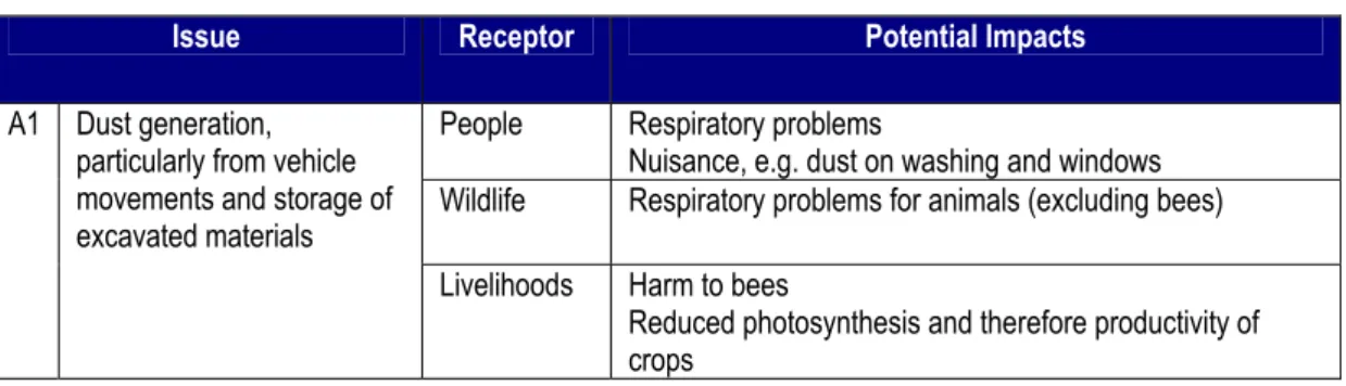
Project activities give rise to issues, which in turn could then cause an impact to an environmental or social receptor. Table 3-1 illustrates the links between activity, issue and potential sources of impact. All SCPX Project activities and associated issues have been identified. Generic Project issues and potential impacts, and route or site-specific issues and potential impacts are tabulated in Appendix B.
Table 3-1: Issues–Receptors–Impacts Example
Issue Receptor Potential Impacts
People Respiratory problems
Nuisance, e.g. dust on washing and windows Wildlife Respiratory problems for animals (excluding bees) A1 Dust generation,
particularly from vehicle movements and storage of excavated materials
Livelihoods Harm to bees
Reduced photosynthesis and therefore productivity of crops
A variety of impacts can occur and are identified and addressed in this ESIA, as defined below:
Negative – an impact that is considered to represent an adverse change from the baseline, or introduce a new undesirable factor
Positive or beneficial – an impact that is considered to represent an improvement to the baseline or introduces a new desirable factor
Direct (or primary) – impacts that result from a direct interaction between a planned Project activity and the receiving environment (e.g. between occupation of the pipeline corridor and pre-existing habitats)
Secondary – impacts that follow on from the primary interactions between the Project and its environment as a result of subsequent interactions within the environment (e.g. loss of part of a habitat affects the viability of a species population over a wider area)
Indirect – impacts that result from other activities that are encouraged to happen as a consequence of the Project (e.g. new business set up to cater for increased traffic on roads)
Transboundary – impacts that extend or occur across a national boundary
Cumulative – impacts that act together with other impacts, from the same or other projects, to affect the same environmental or social resource or receptor. The following types of cumulative impact are discussed in this ESIA:
o Additive - impacts that may result from the combined or incremental effects of future activities (i.e. those developments currently in planning and not included as part of the baseline)
o In-combination - impacts where different types of impact from the project being considered are likely to affect the same environmental or socio-economic features. For example, a sensitive receptor being affected by both noise and dust during construction could potentially experience a combined effect greater than the individual impacts in isolation.
Short-term – impacts that are predicted to last only for a limited period (e.g. during pipeline construction) but will cease on completion of the activity, or as a result of mitigation/reinstatement measures and natural recovery (e.g. temporary employment of unskilled workers during construction)
Long-term – impacts that will continue over an extended period, (e.g. disturbance from inspection vehicles travelling to and from the ROW during pipeline operations) but cease when the Project stops operating. These will include impacts that may be
Approach and Methodology 3-10
intermittent or repeated rather than continuous if they occur over an extended time period (e.g. repeated seasonal disturbance of species as a result of pipeline inspection using existing tracks)
Permanent – impacts that occur during the development of the Project and cause a permanent change in the affected receptor or resource (e.g. damage of a cultural artefact or loss of a mature tree-line) that endures substantially beyond the Project lifetime
Accidental – impacts that result from accidental (unplanned) events within the Project (e.g. fuel spillage during vehicle re-fuelling) or in the external environment affecting the Project (e.g. landslide). In these cases the probability of the event occurring is considered.
3.9.2
Mitigation of Potential Impacts
Mitigation measures are the actions or systems that are used, or have been proposed, to avoid, eliminate, reduce or compensate for impacts that have been identified in screening and further analysed in the impact assessment. In some instances, mitigation will be inherent in design; in others, mitigation measures have been identified by the ESIA process for implementation during design optimisation, construction and operation of the Project. The ESIA process therefore involves identifying where significant impacts could occur and then identifying technically and financially feasible and cost-effective means of mitigating those impacts. These measures are then agreed with the Project team via a multidisciplinary mitigation workshop, and all agreed mitigation measures are integrated into the ESIA. The mitigation measures are tracked through to the Project Commitments Register as clear, unambiguous commitments. In this ESIA the Commitments Register is the authoritative source of all mitigation measures that the Project proposes to make.
Mitigation has been an integral part of the SCPX Project design process and will continue through to construction and operation. Where a significant impact has been identified, a hierarchy of options for mitigation has typically been explored as follows.
Avoid at source – remove the source of the impact
Abate at source – reduce the source of the impact
Attenuate – reduce the impact between the source and the receptor
Abate at the receptor – reduce the impact at the receptor
Remedy – repair the damage after it has occurred
Compensate/offset – replace in kind or with a different resource of equal value. It should be noted that compensation or offset does not automatically make an impact ‘acceptable’ or excuse the need to consider other forms of mitigation as discussed in the hierarchy.
Examples of enhancing beneficial impacts or developing opportunities for positive benefits can include:
Preference for hiring unskilled labour from local communities
Preference for use of local suppliers.
It is important to note that the application of mitigation measures is an iterative process as shown in Figure 3-1, with residual impacts remaining only after all reasonable mitigation measures have been applied, often after several iterations. The process of iteration will continue until an impact is deemed as low as reasonably practicable.
Mitigation measures, already implemented or proposed for the SCPX Project, are discussed in Chapter 10, Environmental and Social Impacts and Mitigations and Chapter 12 Hazard
Approach and Methodology 3-11
Analysis and Risk Assessment, and set out definitively in the Commitments Register. They include, in summary:
Routing of the new SCPX section as close as practicable to the existing BTC and SCP pipelines to overlap with the previous construction ROW
Measures in the Project design (e.g. ensuring pipeline is routed a safe distance from dwellings and communities)
Location of new block valves adjacent to existing facilities
Engineering design solutions during the ESIA process (e.g. increasing pipe burial depth at vulnerable watercourse crossings
Alternative solutions to processes and methods to achieving objectives (e.g. methods of transporting materials, river crossing techniques)
Construction and operational control procedures (e.g. contractor requirements to demarcate work areas to prevent work outside approved zones)
Conservation management (e.g. pre-clearance surveys to remove sensitive fauna from the construction sites)
Management systems (e.g. comprehensive systems of policies, procedures, and industry standards that have been developed and implemented to manage environmental, social, health and safety hazards and risks related to the Project)
Development of policies and procedures to control impacts and apply mitigation measures (e.g. compensation plans for land/livelihoods)
Timing restrictions (e.g. generally no night-time construction activities near villages).
3.9.3
Residual Impacts and Defining Significance
Any impacts remaining after mitigation measures have been applied to the extent that an impact is deemed as low as reasonably practicable are considered residual impacts. The significance level of the residual impact is assessed as a combination of:
The importance/sensitivity of the receptor
The magnitude of the impact.
To allow assessment of impact significance, tables have been specifically developed for this Project to define the importance/sensitivity of receptor and the magnitude of potential impact. These tables are presented in the sections below. Several considerations have been built into the tables including temporal, spatial, impact reversibility, direct and indirect impacts, internationally used emission or ambient quality standards and relevant legal or policy constraints.
It should be noted that any legislation, guidelines and standards described within the significance tables have been used as references only for the purposes of assessment of impact significance and that the applicable legislative requirements for the Project are found within Chapter 6, Policy, Legal and Administrative Framework. Additionally, the legislation and standards referenced are not necessarily in accordance with the environmental and social standards as specified in the HGA.
The significance level is ranked in four categories: high, medium and low adverse and beneficial. These rankings are used for both environmental and social residual impacts. It should be noted that this is a relative assessment and the results of the significance of residual impacts ranging from low to high adverse are a comparative scale that seeks to identify the relative magnitude of the impacts in qualitative terms. The method used for evaluating the level of significance of impacts, before and after implementation of the proposed mitigation measures, is discussed in detail in the sections below.
Approach and Methodology 3-12
It is often difficult to compare residual impacts consistently across different natural and socio-economic environments. Scientific evidence, as well as predictions based on observation of similar activities, has been used in the impact assessment process. Where this is not possible, qualitative judgment has been used to ascribe impact based on the Project and ESIA team’s extensive experience and knowledge.
3.9.4
Importance/Sensitivity of the Receptor
The importance/sensitivity of a receptor has been defined for the Project taking into account such matters as its local, regional, national or international designation, its importance to the local or wider community, its ecosystem function or its economic value. The assessment of the sensitivity of human receptors, for example a household, community or wider social group, has taken into account their likely response to the change and their ability to adapt to and manage the effects of the impact.
The importance/sensitivity of the receptor has been determined on a topic-by-topic basis on an A–E tiered scale, as shown in the topic-based tables in Section 3.9.6 (A = very low; B = low; C = medium; D = high; E = very high).
3.9.5
Magnitude of Potential Impact
The term ‘magnitude’ is used to encompass all the dimensions of the predicted impact including:
The nature of the change (what is affected and how)
Its size, scale or intensity
Its geographical extent and distribution
Its duration, frequency and reversibility.
Project-specific magnitude tables have been developed for each topic listed in Section 3.9.6. The magnitude of the impact has been determined on a 1–5 tiered scale (1 = very small; 2 = small; 3 = medium; 4 = large; 5 = very large). The tables are provided in Section 3.9.6.
To encompass different issues, a number of criteria are defined for each level of impact. Where an impact meets criteria in more than one level of impact, it is categorised according to the highest level, so if an impact meets criteria in both the medium and large categories, it is classed as large. The range of criteria in each level encompasses a number of parameters (e.g. habitats and species are addressed in the ecology table); an impact therefore only has to meet one of the criteria in each category to be assigned that score. In developing criteria for accidental spills or other unplanned events (e.g. gas releases from pig launcher or block valves), a distinction has been drawn between immediate area, localised and widespread damage. There are no fixed rules for determining the boundaries of these zones, but the immediate area is the area immediately covered by the spill and is meant to imply confinement of the spill to this area. Localised means that the spill has spread out to the area around the spill but is confined to the working area (i.e. the area within BP’s control). Widespread implies that the spill has spread out beyond the working area, usually because it has been carried downstream by a watercourse or entered groundwater.
In evaluating cultural heritage and socio-economic impact magnitude criteria, an additional tier of “beneficial” has been added to the tables to allow for the beneficial effects the Project may have on these topic areas.
3.9.6
Impact Significance Assessment Tables
This section presents the topic-based tables that have been used in this ESIA to assess impact significance. Each topic has two associated tables, one indicating
Approach and Methodology 3-13
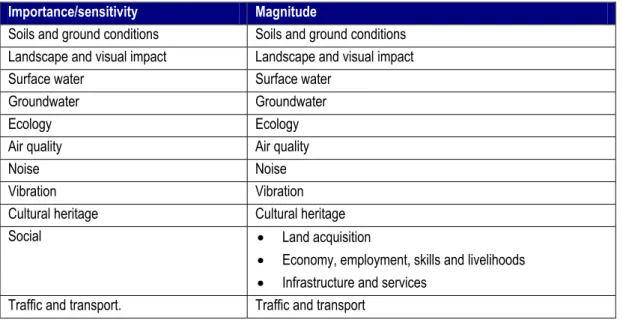
importance/sensitivity of receptors and the other indicating magnitude of impact. The tables are accompanied by text explaining the approach adopted to assess the impacts and identify the criteria used for each topic. Receptor importance/sensitivity and magnitude tables have been developed for the topics outlined in Table 3-2.
Table 3-2: Receptor Importance/Sensitivity and Magnitude Topics
Importance/sensitivity Magnitude
Soils and ground conditions Soils and ground conditions Landscape and visual impact Landscape and visual impact Surface water Surface water
Groundwater Groundwater Ecology Ecology Air quality Air quality
Noise Noise Vibration Vibration Cultural heritage Cultural heritage
Social Land acquisition
Economy, employment, skills and livelihoods
Infrastructure and services Traffic and transport. Traffic and transport
In addition, the Project has carried out a parallel health impact assessment (HIA), which has been executed in close cooperation with the ESIA. Table 3-26 presents a summary of the HIA methodology, which is based on the identification of the health impact and the probability (likelihood) of the impact occurring to determine the overall health risk.
3.9.6.1 Soil and ground conditions
The tables below (Table 3-3 and Table 3-4) consider the potential impact of pipeline on soil productivity, erosion and ground stability. The tables also include criteria for the assessment of impacts of spills or other accidental events on ground conditions.
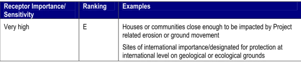
Table 3-3: Importance/Sensitivity of Receptors to Impacts on Soils and Ground Conditions
Receptor Importance/ Sensitivity
Ranking Examples
Very low A Unused land
Low B Land used for grazing by roaming graziers Industrial land
Medium C Agricultural land used for cereals
Land used for permanent grazing or a rotational grazing system High D Land used for horticulture, fruit or other high value crops
Sites valued or designated for protection on the grounds of geology or ecology at national level
Soils with formation rates substantially lower than the moderate soil loss tolerance rate of 5–10te/ha 1yr-1 as these are vulnerable
Approach and Methodology 3-14
Receptor Importance/ Sensitivity
Ranking Examples
Very high E Houses or communities close enough to be impacted by Project related erosion or ground movement
Sites of international importance/designated for protection at international level on geological or ecological grounds
Table 3-4: Ranking of Magnitude of Predicted Impacts on Soils and Ground Conditions
Magnitude Ranking Examples
Very small 1 No detectable effect on soils or ground conditions
Spill or accidental event that causes immediate area damage only and can be restored to an equivalent capability in a period of days or up to a month, i.e. full restoration is achieved as a result of immediate clean-up operations
Small 2 Minor losses of productivity expected to last up to six months after reinstatement
Water remains in surface depressions for less than three months after construction
Soil creep
Spill or accidental event leading to immediate area or localised damage that may take up to six months to restore to pre-existing capability/function
Medium 3 Minor losses of productivity expected to last between 6 and 12 months after reinstatement
Water predicted to remain in surface depressions less than one year after construction but more than three months
Soil erosion evident but not leading to visible rill or gully formation Spill or accidental event leading to immediate area or localised damage that may take between six months to one year to restore to pre-existing capability/function
Spill or accidental event leading to widespread damage that may take up to six months to restore to pre-existing capability/function Large 4 Moderate losses of productivity expected to last between one and
five years after reinstatement
Water predicted to remain in surface depressions for between one and five years after construction
Soil erosion predicted to lead to visible rill or gully formation Landslip or ground subsidence not leading to exposure of the pipe, or extending outside the working area
Spill or accidental event leading to localised damage that cannot be restored to pre-existing capability/function within one year
Spill or accidental event leading to widespread damage that may take six months to one year to restore to pre-existing capability/ function
Approach and Methodology 3-15
Magnitude Ranking Examples
five years after reinstatement
Water predicted to remain in surface depressions permanently Rill and gully formation predicted to be extensive with potential impacts on neighbouring land and pipe integrity
Landslip, ground subsidence or ground collapse that exposes the pipe and/or extends outside the working area
Spill or accidental event leading to widespread damage that cannot be restored to pre-existing capability/function within one year
3.9.6.2 Landscape and visual impact
Assessing the significance of landscape and visual impact is a qualitative process, which relies upon subjectivity and reasoned judgement that is supported, as far as possible, by evidence. Significance is not absolute and can only be defined in relation to each development and its location. Therefore, the criteria and the significance thresholds used are reviewed for each assessment, to ensure they are relevant. The criteria tables below provide a guide only as to the likely level of significance of impacts, and the actual conclusions of the assessment may vary. The full assessment provides an explanation, using well informed and reasoned professional judgement, as to how the conclusions about significance for each effect assessed have been derived.
The approach outlined in Table 3-5 and Table 3-6, is in accordance with UK practice as laid down in the Landscape Institute and Institute of Environmental Management and Assessment’s (IEMA) (2002) Guidelines for Landscape & Visual Impact Assessment, and is considered relevant to this Project.
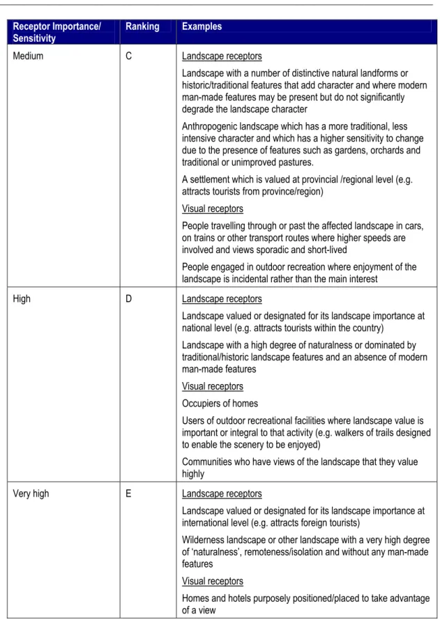
Table 3-5: Importance/Sensitivity of Visual Receptors and Landscapes
Receptor Importance/
Sensitivity Ranking Examples
Very low A Landscape receptors
Landscape that is dominated by derelict, disused or degraded man-made made structures and/ or which is not valued by local communities or others
A natural landscape severely degraded or modified by cultural land uses, such as intensive arable or pastoral agriculture Visual receptors
Receptors with no or very limited views Low B Landscape receptors
A landscape with few intact or distinctive natural or historic features but which is valued at settlement/district/municipal level (e.g. attracts local visitors)
Landscape with large, dominant, numerous and/or noisy modern man-made features
A natural landscape degraded or modified by cultural land uses such as arable or pastoral agriculture
Visual receptors
Approach and Methodology 3-16
Receptor Importance/ Sensitivity
Ranking Examples
Medium C Landscape receptors
Landscape with a number of distinctive natural landforms or historic/traditional features that add character and where modern man-made features may be present but do not significantly degrade the landscape character
Anthropogenic landscape which has a more traditional, less intensive character and which has a higher sensitivity to change due to the presence of features such as gardens, orchards and traditional or unimproved pastures.
A settlement which is valued at provincial /regional level (e.g. attracts tourists from province/region)
Visual receptors
People travelling through or past the affected landscape in cars, on trains or other transport routes where higher speeds are involved and views sporadic and short-lived
People engaged in outdoor recreation where enjoyment of the landscape is incidental rather than the main interest
High D Landscape receptors
Landscape valued or designated for its landscape importance at national level (e.g. attracts tourists within the country)
Landscape with a high degree of naturalness or dominated by traditional/historic landscape features and an absence of modern man-made features
Visual receptors Occupiers of homes
Users of outdoor recreational facilities where landscape value is important or integral to that activity (e.g. walkers of trails designed to enable the scenery to be enjoyed)
Communities who have views of the landscape that they value highly
Very high E Landscape receptors
Landscape valued or designated for its landscape importance at international level (e.g. attracts foreign tourists)
Wilderness landscape or other landscape with a very high degree of ‘naturalness’, remoteness/isolation and without any man-made features
Visual receptors
Homes and hotels purposely positioned/placed to take advantage of a view
Table 3-6: Ranking of Magnitude of Assessed Impacts on Visual Receptors and Landscape Character
Magnitude Ranking Examples
Very small 1 Small or imperceptible change in components of the landscape or introduction of a new element that is in keeping with the
Approach and Methodology 3-17
Magnitude Ranking Examples
surroundings or no appreciable change to existing views Small 2 Development would result in minor changes in views without
affecting overall quality of views
Minor permanent change in the landscape – new element is only slightly out of character, existing landscape quality is maintained Temporary change where baseline landscape character is predicted to be restored within 1–2 years
Medium 3 The development would result in a noticeable change in the existing view and or would cause a noticeable change in the quality and/or character of the view
Permanent changes in the landscape predicted in a localised area; new element may be prominent, but not significantly uncharacteristic
Temporary changes where baseline landscape character is predicted to be restored in 2–5 years
Large 4 The development would result in a prominent change in the existing view and/or would cause a prominent change in the quality and/or character of the view
Permanent changes over an extensive area and/or new development that will result in significant negative change to the existing landscape character (e.g. because of loss of key elements of the existing landscape, or introduction of elements that are uncharacteristic compared to existing features) Temporary changes where baseline landscape character is predicted to be restored in 5–10 years
Very large 5 Development will dominate the view or result in a dramatic change to the quality and/or character of the view
Permanent change over an extensive area and/or introduction of elements that will fundamentally change the landscape character Temporary changes where restoration of baseline landscape character is predicted to take longer than 10 years
3.9.6.3 Surface water
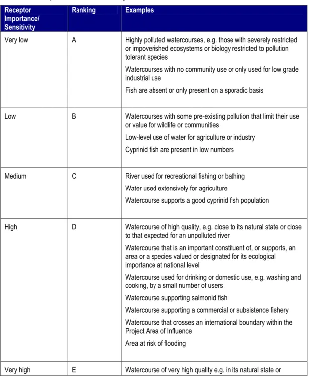
The significance of any potential impact on water quality and quantity will depend on the current (or designated) use of the resource (e.g. for drinking water, irrigation, industrial process water, fishing, domestic use) or its importance to ecology and the nature and magnitude of change caused by the Project. Table 3-7 therefore defines receptors with regard to the use they make of the water resource or the ecological importance of the resource.
For pipeline and associated construction activities, there are likely to be three main types of impact:
Planned discharges of treated sanitary sewage and process wastewater (e.g. stormwater run-off from construction camps, run-off from vehicle wash-down areas and hydrostatic test water)
Disturbance of watercourses directly through physical works, and indirectly due to run-off containing suspended solids from working and reinstated areas
Approach and Methodology 3-18
Planned discharges will be treated to specified Project standards, which are defined in Appendix B of the ESMMP (Appendix D).
The magnitude of these impacts to water quality (and secondary impacts to water users) are therefore based largely on compliance with these discharge standards, together with the impact on the quality of the receiving watercourse, again as defined following a review of available standards and guidance, see Appendix B of the ESMMP (Appendix D).
The other types of impact do not lend themselves to being easily quantified in terms of standards or impact prediction. Table 3-8 therefore includes several descriptions of potential scenarios/impacts to facilitate reaching an assessment of impact magnitude.
Table 3-7: Importance/Sensitivity of Surface Water Resources and Users
Receptor Importance/ Sensitivity
Ranking Examples
Very low A Highly polluted watercourses, e.g. those with severely restricted or impoverished ecosystems or biology restricted to pollution tolerant species
Watercourses with no community use or only used for low grade industrial use
Fish are absent or only present on a sporadic basis
Low B Watercourses with some pre-existing pollution that limit their use or value for wildlife or communities
Low-level use of water for agriculture or industry Cyprinid fish are present in low numbers
Medium C River used for recreational fishing or bathing Water used extensively for agriculture
Watercourse supports a good cyprinid fish population
High D Watercourse of high quality, e.g. close to its natural state or close to that expected for an unpolluted river
Watercourse that is an important constituent of, or supports, an area or a species valued or designated for its ecological importance at national level
Watercourse used for drinking or domestic use, e.g. washing and cooking, by a small number of users
Watercourse supporting salmonid fish
Watercourse supporting a commercial or subsistence fishery Watercourse that crosses an international boundary within the Project Area of Influence
Area at risk of flooding
Approach and Methodology 3-19
Receptor Importance/ Sensitivity
Ranking Examples
corresponding to that expected for an unpolluted river
Watercourse that is an important constituent of, or supports, an area or a species valued or designated for its ecological importance at international level
Watercourse used for drinking or domestic use, e.g. washing and cooking, by a large number of users
Watercourse that supports a very good salmonid fishery
Table 3-8: Ranking of Magnitude of Predicted Impacts on Surface Water
Magnitude Ranking Examples
Very small 1 Direct or indirect impacts largely not discernible No effect on users
Spill or accidental event that causes immediate area damage only and can be restored to an equivalent capability in a period of days or up to a month, i.e. full restoration is achieved as a result of immediate clean-up operations
Small 2 Project effluent/discharge within effluent quality standards and does not breach ambient environmental quality standard for the receiving watercourse
Physical disturbance of watercourse limited to immediate working area
Visible sediment and obscuration of watercourse bed observed for less than 1 week
<15% decrease of downstream river flowrate for no more than 1 week
Minor shift away from baseline conditions. Direct or indirect impacts will be discernible but use and value of resource not impacted. Rapid return to baseline conditions on completion of Project activities (guide timescale: within 1 to 3 months depending on receptor)
Spill or accidental event leading to immediate area or localised damage that may take up to 6 months to restore to pre-existing capability/function
Medium 3 Visible sediment and obscuration of watercourse bed observed for 1–3 weeks after completion of construction
<15% decrease of downstream river flowrate for more than one week or 15-40% decrease of downstream river flowrate for no more than 1 week
Direct or indirect impacts to users or the value of the resource such that character/composition/ attributes of the resource temporarily changed and/or use temporarily affected or restricted but the overall integrity of the resource is not threatened. Guide timescale for return to baseline conditions: 3–6 months depending on receptor
Approach and Methodology 3-20
Magnitude Ranking Examples
damage that may take between 6 months to one year to restore to pre-existing capability/function
Spill or accidental event leading to widespread damage that may take up to six months to restore to pre-existing capability/function Large 4 Project effluent/discharge breaches effluent quality standards or
ambient environmental quality standard for the receiving water body but rapidly diluted
Visible sediment and obscuration of watercourse bed observed for more than 3 weeks but less than 3 months after construction 15–40% decrease of downstream river flowrate for more than one week or >40% decrease of downstream river flowrate for no more than 1 week
Project causes temporary flooding over a small area Direct or indirect impacts to other users or the value of the resource such that character/ composition/ attributes of the resource post development are changed, threatening the overall integrity of the resource, or use by others significantly restricted on a temporary basis. Guide timescale for return to baseline conditions: 6-12 months
Spill or accidental event leading to localised damage that cannot be restored to pre-existing capability/function within one year Spill or accidental event leading to widespread damage that may take six months to one year to restore to pre-existing capability/ function
Very large 5 Project effluent/discharge breaches effluent quality standards or ambient environmental quality standard for the receiving water body and receiving water body has poor dilution capacity Visible sediment and obscuration of watercourse bed observed for more than 3 months after construction
>40% decrease of downstream river flowrate for more than 1 week
Project causes temporary flooding over a large area Total loss or very major alteration to key elements/features of watercourse such that post development character/composition/ attributes will be fundamentally changed and may be lost altogether or use by others permanently impacted. Guide timescale for return to baseline conditions: 12 months or more Spill or accidental event leading to widespread damage that cannot be restored to pre-existing capability/function within one year
3.9.6.4 Groundwater
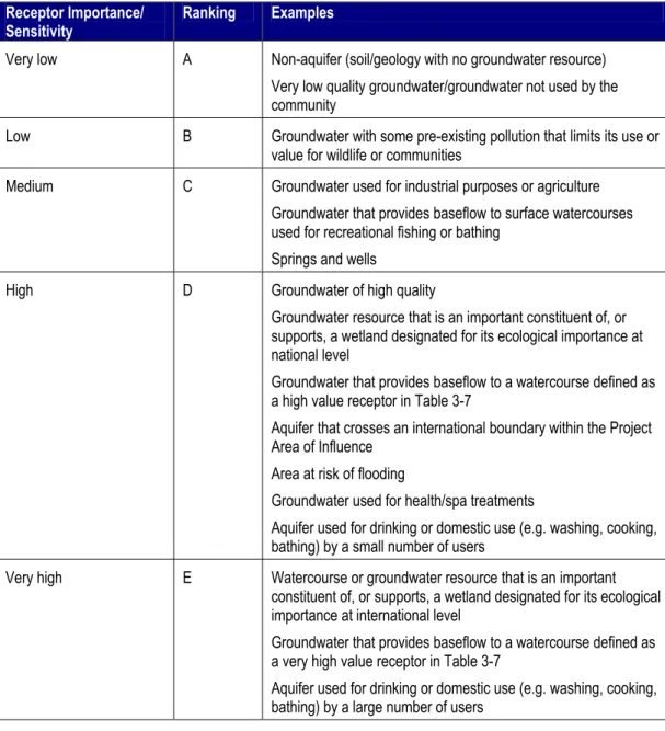
The significance of any potential impact on groundwater quality and quantity will depend on the current (or designated) use of the resource (e.g. for drinking water, irrigation, industrial process water, domestic use) or its importance to ecology and the nature and magnitude of change caused by the Project. Table 3-9 below therefore defines receptors with regard to the use they make of the water resource or the ecological importance of the resource.
Approach and Methodology 3-21
For pipeline and facility construction activities, there will be three main types of potential impact. Note that there are currently no planned discharges to groundwater:
Potential impacts on groundwater quality or quantity due to dewatering of the trench in areas of high groundwater, abstraction for use during construction
Disturbance of groundwater directly through physical works or construction through aquifers, where non-open-cut crossing methods are used
Accidental events or pollution.
These impacts do not lend themselves to being easily quantified.
Table 3-10 below therefore includes several descriptions of potential scenarios/impacts to facilitate reaching an assessment of impact magnitude.
Table 3-9: Importance/Sensitivity of Groundwater Resources and Users
Receptor Importance/
Sensitivity Ranking Examples
Very low A Non-aquifer (soil/geology with no groundwater resource) Very low quality groundwater/groundwater not used by the community
Low B Groundwater with some pre-existing pollution that limits its use or value for wildlife or communities
Medium C Groundwater used for industrial purposes or agriculture Groundwater that provides baseflow to surface watercourses used for recreational fishing or bathing
Springs and wells
High D Groundwater of high quality
Groundwater resource that is an important constituent of, or supports, a wetland designated for its ecological importance at national level
Groundwater that provides baseflow to a watercourse defined as a high value receptor in Table 3-7
Aquifer that crosses an international boundary within the Project Area of Influence
Area at risk of flooding
Groundwater used for health/spa treatments
Aquifer used for drinking or domestic use (e.g. washing, cooking, bathing) by a small number of users
Very high E Watercourse or groundwater resource that is an important constituent of, or supports, a wetland designated for its ecological importance at international level
Groundwater that provides baseflow to a watercourse defined as a very high value receptor in Table 3-7
Aquifer used for drinking or domestic use (e.g. washing, cooking, bathing) by a large number of users
Approach and Methodology 3-22
Table 3-10: Ranking of Magnitude of Predicted Impacts on Groundwater
Magnitude Ranking Examples
Very small 1 Direct or indirect impacts largely not discernible. No effect on users
Spill or accidental event that causes immediate area damage only and can be restored to an equivalent capability in a period of days up to a month, i.e. full restoration is achieved as a result of immediate clean-up operations
Small 2 Groundwater abstraction does not exceed recharge rate. Spill or accidental event leading to immediate area or localised damage that may take up to 6 months to restore to pre-existing capability/function
Medium 3 Groundwater abstraction exceeds the natural low flow groundwater recharge rate but users and groundwater levels within any receiving water body, river or wetland are not affected and saline intrusion does not occur
Spill or accidental event leading to immediate area or localised damage that may take between 6 months to one year to restore to pre-existing capability/function
Spill or accidental event leading to widespread damage that may take up to six months to restore to pre-existing capability/function Large 4 Groundwater abstraction exceeds the natural high flow
groundwater recharge rate leading to minor changes of groundwater levels within any receiving water body, river or wetland but not to saline intrusion
Project causes temporary flooding over a small area Direct or indirect impacts to other users or the value of the resource such that character/composition/attributes of the resource such that post development
character/composition/attributes changed or use by others significantly restricted on a temporary basis
Spill or accidental event leading to localised damage that cannot be restored to pre-existing capability/function within one year Spill or accidental event leading to widespread damage that may take six months to one year to restore to pre-existing capability/ function
Very large 5 Groundwater abstraction exceeds the natural high flow groundwater recharge rate leading to significant depletion of groundwater levels within any receiving water body, river or wetland and/or to saline intrusion
Project causes temporary flooding over a large area Total loss or very major alteration to key elements/features of watercourse or aquifer such that post development character/ composition/attributes will be fundamentally changed and may be lost altogether or use by others permanently impacted
Spill or accidental event leading to widespread damage that cannot be restored to pre-existing capability/function within one year
Approach and Methodology 3-23
3.9.6.5 Ecology
Ecological impacts have been evaluated taking account of the following factors:
The magnitude of the impact, as determined by its intensity, its extent in space and time
The vulnerability of the habitat or species to the change caused by the impact
The ability of that species or habitat to recover
The value, in nature conservation and ecological terms of affected receptors including species, populations, communities, habitats, landscapes and ecosystems. Both indirect and direct impacts are included in the assessment of the significance of impacts – for example, the loss or alteration of a feeding area for a rare bird and impacts on a protected area off-site because they are connected to the pipeline route, e.g. by a watercourse. Impacts on species behaviour or interactions have also been assessed, for example, consideration of impacts from noise and lighting.
The scientific value of habitats for nature conservation is assessed according to widely accepted criteria of which the most important are naturalness, extent, rarity, and diversity. These and others are described in an extensive literature (Ratcliffe, 1977; Usher, 1986). Rarity and extent are assessed at several scales: in the context of occurrence on the proposed pipeline route, in the context of the surrounding ecosystem, and at a national and international scale. For example, habitats that are rare at an international scale would be considered the most important for nature conservation, while habitats that are rare on the proposed pipeline route or facility locations, but common in the context of the surrounding ecosystem, would be considered important at a site level. The ability of habitats to recover from change is also assessed based on the experience gained from monitoring of the BTC and SCP pipelines following construction.
The ecological importance of species is assessed according to two main criteria:
International significance according to the IUCN Red List of threatened species
Species listed in the Country Red Data Book.
Table 3-11 defines the ecological receptors with regard to sensitivity, taking into consideration the value and ecological importance of different habitats and species. Table 3-12 defines the magnitude of the potential impact, including several descriptions of potential scenarios/impacts to facilitate reaching an assessment of impact magnitude. Table 3-11: Importance/Sensitivity of Ecological Receptors
Receptor Importance/
Sensitivity Ranking Examples
Very low A Commonly occurring habitats and species, not subject to significant decline
Habitats that are already disturbed or which are periodically subject to natural disturbance (e.g. arable fields or areas affected by existing infrastructure/development)
Low B Sites of local biodiversity value but not intact, fragile or unique Wildlife corridors
Habitats that recover quickly following disturbance (i.e. habitats comprising species that readily re-colonise disturbed areas) Widespread common species with low biodiversity value and not listed on the CITES, IUCN or Azeri Red List Species
Approach and Methodology 3-24
Receptor Importance/ Sensitivity
Ranking Examples
Medium C Sites of regional importance
Habitats that are suffering significant decline at a national or regional level
Habitats of high species or habitat diversity or ‘naturalness’ Habitats that are capable of unassisted recovery to natural conditions following disturbance, although this may require several years (e.g. chal meadows, reed swamps and other habitats where growing conditions are favourable) Sites of research or educational value
Regionally important (in the country context) population of a species, either because of population size or distributional context Species in significant decline at national or regional level
Species listed as rare at country level (i.e. listed in the country Red Data Book) or species listed on the IUCN Red List that either:
occur on the proposed route but are unlikely to be affected by it (e.g. owing to large populations off the route or type of use of the area, such as raptors foraging over, but not breeding on, the route), or
are unlikely to be present on the pipeline route High D Sites designated for protection at national level
Habitats recognised as intact or unique (e.g. true deserts, fragile soils, coastal areas, estuaries and wetlands) or areas recognised by NGOs as having high environmental value (e.g. key bird areas)
Habitats that are unlikely to return to natural conditions without some intervention (such as re-seeding or planting), but which are capable of assisted recovery (including most semi-deserts) Species listed as rare at country level (i.e. listed in the country Red Data Book) or species listed on the CITES, IUCN that have either been recorded on the pipeline route of facility area or are likely to be present, based on known distribution and habitat availability, and are likely to be affected by it
The presence of a nationally important population of a species on the pipeline route or which could be affected indirectly
Very high E Sites of international importance/designated for protection at international level
Areas recognised as intact and fragile and unique or areas recognised by NGOs as having high environmental value Habitats that are very difficult to restore to natural conditions (even with biorestoration) such as salt-deserts and arid deserts Species that are rare at an international level
Natural or critical habitat as defined in IFC P-S 61
1 Natural habitats are land and water areas where the biological communities are formed largely by native plant
and animal species, and where human activity has not essentially modified the area’s primary ecological functions. Habitat may be considered to be critical by virtue of (i) its high biodiversity value; (ii) its importance to the survival of endangered or critically endangered species; (iii) its importance to endemic or geographically