We
move
transportation master plan
transportation and land use integration
An integrated approach to planning and developing the transportation system and land uses supports the creation of an efficient, sustainable, compact and vibrant city that maximizes the effectiveness of its investment in transportation infrastructure.
public transportation as a cornerstone
A comprehensive public transportation system supports a sustainable, livable city where more people use transit as a preferred transportation choice.
encouragement of active transportation
A walkable, cycle-friendly city supports the creation of a healthy, barrier-free, age-friendly and safe city where active modes are a preferred transportation choice.
manage the transportation system
more effectively
A comprehensive strategic approach to roads balances the objectives of the transportation system by focusing roadway expansions to improve the efficiency of goods, services and transit movements while using transportation operation, supply and demand management strategies to manage roadway congestion.
summary of
tmp Directions
roadway improvements focus on
efficient goods movement
An efficient network for goods and services movements incorporates integrated multimodal and regional
approaches to support commercial transportation needs.
regional interface
A comprehensive, coordinated and integrated transportation system supports regional mobility, accessibility and economic vitality.
Well-maintained and managed infrastructure
A holistic approach to infrastructure investments supports the fiscal sustainability of the transportation system by considering life-cycle costs, adhering to a service life based asset management program and providing a robust operational maintenance program to facilitate year round transportation.Summary of tmp Directions 1
executive Summary 3
1.0 introduction 12
1.1 What is the Way We move? 12
1.2 Context 12
1.3 Achieving the City Vision 14
1.4 Aligning with edmonton’s Other Strategic plans 14
1.5 How Was The Way We Move prepared? 15
1.6 Next Steps 15
2.0 strategic Goals 16
3.0 current and future conditions 24
3.1 Current Conditions 24
3.2 Future Conditions 29
4.0 transportation and land use integration 34
background 34
4.1 Integrating transit with Land Use 36
4.2 Integrating roadways with Land Use 39
4.3 Community building 40
4.4 regional Context 41
5.0 public transportation 42
background 43
5.1 Light rail transit (Lrt) Network 44
5.2 bus System 47
5.3 Services for Customers with
mobility Challenges 49
5.4 park and ride 50
5.5 essential Supporting measures 51
5.6 taxis 53
5.7 regional Connections 53
6.0 active transportation 54
background 54
6.1 Walking 56
6.2 Cycling 57
6.3 Shared-Use Facilities 58
6.4 Safety 59
6.5 regional Connections 59
7.0 roads 60
background 61
7.1 road System and responsibilities 62
7.2 management of the road System 66
7.3 Automobile parking 71
7.4 road Safety 72
7.5 transportation Impacts on Communities 73
8.0 Goods and services movement 74
background 74
8.1 existing road System 76
8.2 Key Industrial Areas 78
8.3 rail 78
8.4 Air 80
9.0 regional interface 82
background 82
9.1 regional public transportation 85
9.2 regional roads 86
9.3 Other modes 86
10.0 asset management and maintenance 88
background 89
10.1 Asset management 90
10.2 maintenance 92
11.0 implementation 94
11.1 Implementation plan 94
11.2 progress measurement 94
11.3 Updates 96
Glossary 97
appenDices 109
Appendix 1: City Vision, principles
and Strategic Goals 110
Appendix 2: Subsidiary plans, policies,
Transportation is more than moving people, goods and services on Edmonton
roads, rails, buses, sidewalks, and light rail transit. It is essential infrastructure
that shapes our urban form, impacts our economic well being and is a primary
determinant of our city’s environmental, financial and social sustainability.
How easily we move through our city, the distances we must travel, the transportation choices we have and how readily we can move between different transportation modes profoundly affects our relationship with the city, the environment and each other. As the major urban centre of regional industrial development, our city’s transportation system is a contributing factor to the economic vitality and competitive advantage of Edmonton and the Capital Region.
We are building a 21st century city, shaping an Edmonton that will meet the needs of our diverse and growing urban and regional population. Growing environmental concerns, acknowledgment of the ongoing investment needed to maintain our transportation infrastructure and the rapid growth of our city demand a shift in transportation priority setting. It is a shift from single passenger vehicle use to more public transit; from building outward to a compact urban form. From an auto oriented view of transportation to a more holistic view of an interconnected, multi-modal transportation system where citizens can walk, bike, bus and train efficiently and conveniently to their desired location. In 2007, Edmontonians offered their experiences and insights into the kind of city they envisioned Edmonton to be by 2040, resulting in the City Vision. Edmontonians also offered their views on our approach to land use (The Municipal Development Plan, The Way We Grow) and on transportation and the movement of people, goods and services (The Transportation Master Plan, The Way We Move).
eXeCUTIve
SUmmaRy
To achieve the City Vision, City Council has identified six 10-year Strategic Goals that are outlined in The City of Edmonton’s 2009-2018 Strategic Plan, The Way Ahead: Preserve and Sustain Edmonton’s Environment; Improve Edmonton’s Livability; Transform Edmonton’s Urban Form; Shift Edmonton’s Transportation Mode; Ensure Edmonton’s Financial Sustainability; and Diversify Edmonton’s Economy. The Transportation Master Plan (TMP) is consistent with and supportive of these goals. The Transportation Master Plan is guided by and intended to achieve the City Vision. It establishes the framework for how the City of Edmonton will address its future transportation needs and is aligned with the Municipal Development Plan, The Way We Grow, to acknowledge that land use and transportation are inextricably linked. The Transportation Master Plan is based on seven Transportation Strategic Goals that define a vision for the transportation system. Each of these goals embodies the four guiding principles (integration, sustainability, livability, innovation) of The Way Ahead. These will guide City policies and direction on how best to manage the transportation system to contribute to the City Vision. Together these goals contribute to creating the kind of safe, vibrant, economically robust, culturally active and environmentally sustainable city Edmontonians said they envision.
transportation strateGic Goals:
(cHapter 2)
Transportation and Land Use Integration
The transportation system and land uses/urban design complement and support each other so that the use of transit and transportation infrastructure is optimized and supports best practices for land use.
Access and Mobility
The transportation system is
interconnected and integrated to allow people and goods to move efficiently throughout the city and to provide reasonable access with a variety of modes for people across demographic, geographic, socio-economic and mobility spectrums.
Sustainability
Transportation decisions reflect an integrated approach to environmental, financial and social impacts thereby creating sustainable, livable communities that minimize the need for new
infrastructure and increase quality of life. Health and Safety
The transportation system supports healthy, active lifestyles and addresses user safety and security including access for emergency response services, contributing to Edmonton’s livability. Transportation Mode Shift
Public transportation and active transportation modes are the preferred choice for more people making it possible for the transportation system to move more people more efficiently in fewer vehicles.
Well-Maintained Infrastructure The transportation system is planned and developed so that the city is able to keep it in a good state of repair and future growth is accommodated in a fiscally responsible and sustainable manner. Economic Vitality
Efficient movement of goods, convenient mobility of the labour force and access to a vibrant city centre are features of the transportation system that enhances the economic vitality and competitive advantage of Edmonton and the Capital Region.
current anD
future conDitions
(cHapter 3)
transportation anD lanD
use inteGration (cHapter 4)
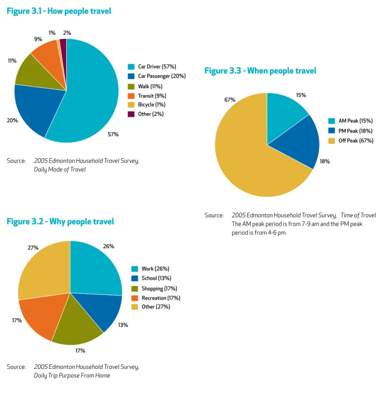
In 2009, Edmonton is home toapproximately 750,000 people and by 2040 will grow by 400,000 people. Edmonton’s 2005 Household Travel Survey showed that of the 2.5 million trips made each day, Edmontonians traveled by car (77%), walking (11%), public transportation (9%), and bicycle (1%). This is one of the highest car dependence rates in Canada.
Edmontonians are spending more time in their cars, driving longer distances and dealing with increasingly congested streets. Between 1994 and 2005, Edmonton’s population increased 13%. At the same time, the total amount of kilometres traveled by automobile in the city increased 32%. This shows that the amount of automobile travel is increasing at a much faster rate than the population. The result is increased roadway
congestion that impedes the efficient movement of people, goods and emergency response services. This car dependence contributes to a cycle of increased kilometres traveled, increased road congestion and the perceived need to build more roadways which will require more taxpayer dollars for operation and maintenance.
The City will integrate land use planning and transportation decisions to create a compact and efficient urban form.
Transportation provides access to land, thereby affecting its desirability and value, while the mix and intensity of land uses results in activities that generate demands on the transportation system. Building communities around effective transit service will decrease the need for other public infrastructure investment throughout the region, and provide viable alternative transportation modes that lower Edmonton’s carbon and ecological footprint and lessen demand on energy and natural resources. Focusing industrial developments in close proximity to goods and services movement corridors is efficient, adds to the economic vitality of the city and Capital Region and reduces goods and services movement traffic through residential areas.
This is a fiscally and environmentally unsustainable cycle. In addition, there are major health risks associated with long trip distances and automobile dependence such as physical inactivity, air pollution, motor vehicle collisions and mental health effects.
Developing and expanding the existing public transportation system while capitalizing on new opportunities for public transportation within the greater Edmonton area are cornerstones of the Transportation Master Plan. To make public transportation the
preferred choice of more people, Edmonton must make a large series of
improvements to the transit system as well as to its physical, social and economic context. A comprehensive public transportation system made up of a variety of service strategies, including premium transit, bus service and disabled adult
transit service (DATS) is a key to achieve the City Vision and Strategic Goals. To achieve this, the City will:
• Pursue expansion of the LRT to all sectors with a goal to increase transit ridership and transit mode split, and spur the
development of compact, urban communities.
• Pursue implementation of an expanded, city-wide premium transit network which will provide faster, more reliable
service with direct connections to major destinations. • Develop an efficient, effective, accessible and
integrated bus, premium bus and LRT network to serve Edmonton with connections to the Capital
Region. The network will include services for persons with mobility challenges.
• Use technology such as transit priority, passenger information systems and
ITS to improve the reliability, efficiency and passenger
information systems to make transit a more competitive
mode of travel.
public transportation
roaDs (cHapter 7)
Roads are the foundation of Edmonton’s transportation system. Roads significantly affect the economic vitality and competitiveness of Edmonton and the Capital Region, as they facilitate the movement of goods and services, emergency response services, and people using public transit, vehicles, taxis, bicycles and active modes. As Edmonton evolves from a mid-size prairie city to a large metropolitan area, it is inevitable that congestion levels will increase, particularly during peak periods. Physical, financial and community constraints in many areas make it unfeasible or even undesirable to build or expand roads to alleviate congestion. As such, the City of Edmonton will need to place greater emphasis on strategies to optimize the use of the existing road system.
These strategies include:
• Land use development strategies
• Promoting use of transit and active transportation modes • Managing existing roadways more efficiently
• Transportation Demand Management (TDM) • Selectively adding more roadway capacity
The City will attempt to maintain or improve the level of service for transit and goods and services movement by giving priority to roadway projects that enhance these movements. Adding roadway capacity to serve commuter traffic will not be a priority for major road projects. The focus of improvements for commuter traffic will be on optimizing the existing roadway operations.
actiVe transportation
(cHapter 6)
Active transportation is any mode of transportation by which people use their own energy to power their motion such as biking or walking. Some of the benefits of active modes of transportation are that it builds health and exercise into one’s daily routine, helps to create a strong sense of community, and reduces the greenhouse gas emissions related to transportation by reducing vehicle volumes and maximizing the effective use of existing infrastructure.
To encourage more active transportation, the City will create a more walkable environment, a cycle-friendly city and an integrated network of multi-use trail facilities.
Active transportation should be viewed as being year round and available for all citizens; therefore the city must have a robust maintenance policy for all seasons.
GooDs anD serVices moVement (cHapter 8)
The Capital Region, including Edmonton, is a major manufacturing, logistics and distribution centre. It is essential to the economy that commercial transportation is able to move freely throughout the Region. Safe, efficient and effective movement of people, goods and services is essential to supporting and fostering the economic vitality and competitive advantage of Edmonton and the Region. An efficient system is cost effective in terms of time, energy consumption and infrastructure needs.Key corridors for the movement of goods and services are: • Outer Ring Road – Anthony Henday Drive
• Inner Ring Road – Consists of Yellowhead Trail, 170 Street, 75 St/ Wayne Gretzky Drive, Whitemud Drive
• Highway Connectors – Yellowhead Trail, Whitemud Drive, Calgary Trail, and others In addition to these corridors, rail and air transport are important components of the regional transportation network. The City of Edmonton will work with other jurisdictions to ensure that Edmonton has a safe and efficient goods
movement network that connects well with other transportation modes and facilities.
reGional
interface
(cHapter 9)
As Alberta’s capital city and the major urban centre within the Capital Region, Edmonton has become the focus of complex issues that demand a regional perspective. The Capital Region Board, made up of Edmonton and twenty-four surrounding municipalities, is a decision making body that was established by Provincial legislation in April 2008. The Board’s mandate is to create a comprehensive plan to manage regional growth, the Capital Region Growth Plan, with the initial phase having been completed in June 2009.
The City, as part of the Capital Region Board, will work constructively with the Capital Region Board as it prepares the Capital Region Growth Plan and conform to the plan once it is formally adopted. In addition, the City will work with the Capital Region Board to cooperatively plan and implement system improvements such as:
• Region-wide system of inter-municipal transit • Region-wide land use planning principles to support
compact growth
• Inter-modal facilities and connections to support rail and air transportation
• Roads of regional significance within the city as well as highway facilities with cooperation of the Province. • Regional multi-use facilities and TDM initiatives.
asset manaGement anD maintenance
(cHapter 10)
implementation (cHapter 11)
City-owned infrastructure, valued in the billions of dollars, include significant transportation assets that are incontinuous need of maintenance, repair, rehabilitation or replacement. With limited budgets and increasing demands on the transportation network, the City is challenged to manage its assets in a way that minimizes
total life-cycle costs yet sustains expected levels of service and safety. The City will use best asset management practices to preserve infrastructure and minimize total life cycle costs.
Operational maintenance of the transportation system such as cleaning and snow plowing are critical to maintaining system safety and accessibility, particularly for active modes. The City
will have robust maintenance practices to facilitate year round transportation.
The Transportation Master Plan and its policies are strategic in nature. An
Implementation Plan that outlines plans, program and actions will be developed to bring the policies into reality. The Implementation Plan, to be updated every three
years, will outline the specific projects, programs and initiatives that will be carried out to achieve the Transportation Strategic Goals.
Progress measures will be developed and reported yearly to create an effective monitoring framework for the TMP that closely considers the
Transportation Strategic Goals and Objectives. Emphasis will be placed on progress measures that track system-wide, long-term changes and
The Way We Move is the Transportation Master Plan (TMP) that establishes a framework for how the City of Edmonton will address its future transportation needs. Edmonton is the fifth largest of Canada’s municipalities with a population of approximately 750,000 people in 2009. It is at the heart of a thriving region which currently includes over one million people in the Census Metropolitan Area (CMA).
Over the next 30 years, the City of Edmonton’s population is expected to exceed one million people, while the CMA will exceed 1.6 million people. This growth will bring about enormous levels of change and challenge as the City delivers services to many new people, businesses and industries. The TMP reflects citizens’ values and directs appropriate decision making while considering the long term and often indirect impacts of those decisions. Its Strategic Goals, Objectives and Actions give direction for the management of the transportation system, and provide a basis for making strategic planning and budgetary decisions.
Provincial
The Province of Alberta’s City Transportation Act requires the City of Edmonton to prepare a comprehensive report (TMP) for an integrated transportation system to serve the city’s needs.
The Capital Region Plan
On April 15, 2008, the Alberta Government created the Capital Region Board and gave it the mandate to prepare a comprehensive Regional Growth Plan. The board consists of 25 participating municipalities of the Capital Region. On April 2, 2009, the Capital Region Board submitted the
Capital Region Growth Plan: Growing Forward to the Alberta Government. The Growth Plan includes four components: a Land Use Plan, an Integrated Transit Network Plan, a Geographic Information Services (GIS) Plan and a Housing Plan.
The plan contains 22 detailed policies that fall under the following six principles. The Way We Move is consistent with these principles and policies.
I: Protect the Environment and Resources II: Minimize Regional Footprint
III: Strengthen Communities IV: Increase Transportation Choice V: Ensure Efficient Provision of Services VI: Support Regional Economic Development
Context
1.0 introDuction
What is
The Way We Move
?
The City of Edmonton is currently aligning its strategic planning processes to ensure an integrated and holistic approach toward city building over the next three decades (See Appendix 1 for more details). The Transportation Master Plan aligns with:
• The Way We Grow: The Municipal Development Plan - This plan establishes Council’s policy direction for future land development and redevelopment decisions. It parallels the 30 year timeframe of the TMP.
• The Way We Green: Edmonton’s Environment Plan - An update of the EcoVision Edmonton Plan which outlines Edmonton’s vision for an environmentally sustainable city. It includes the Environmental Strategic Plan and the Natural Connections Strategic Plan.
• The Way We Live: Edmonton’s People Plan - Guides future sustainable investment in people services and programs that contribute to Edmontonians’ health, safety and social well-being.
• The Way We Prosper: Edmonton’s Plan to Diversify and Maximize the Economy - To be developed
• The Way We Finance: Edmonton’s Financial Sustainability Plan – To be developed
• Infrastructure Strategy - A comprehensive and sustainable long term financial strategy that allows the City of Edmonton to address its increasing infrastructure gap. The plan will identify the infrastructure demand for the next 30 years and estimate the associated costs including renewal, asset operation, maintenance and service delivery.
The Transportation Master Plan and the Municipal Development Plan have been developed concurrently in acknowledgment that land use and transportation are inextricably linked. The preparation of both statutory plans must be approached in an integrated manner and be informed by the Infrastructure Strategy to successfully achieve the City’s goals.
Aligning with Edmonton’s
Other Strategic Plans
This plan is guided by and meant to achieve the City Vision, which is a creative description of Edmonton’s future. The vision guides our decisions, helps us set direction and encourages us to align our priorities as we work to make Edmonton the city we want it to become in 2040. The City Vision is included in Appendix 1.
City of Edmonton 10-Year Strategic Plan
The City of Edmonton Strategic Plan gives direction for the next ten years towards achieving the City Vision. It provides a focus to the City’s efforts to deliver the greatest value of services and infrastructure that are most important to Edmontonians, while managing the opportunities and challenges of our rapidly growing and changing city. Four principles underpin the development and
implementation of the City of Edmonton Strategic Plan (see Appendix 1 for elaboration):
• Integration • Sustainability • Livability • Innovation
To further focus the City’s efforts on achieving the vision, Council identified six 10-year Strategic Goals. These goals will direct long term planning for the City and help set priorities for the delivery and improvement of services, programs and infrastructure.
The 10-year Strategic Goals are (See Appendix 1 for elaboration):
• Preserve and Sustain Edmonton’s Environment • Improve Edmonton’s Livability
• Transform Edmonton’s Urban Form • Shift Edmonton’s Transportation Modes • Ensure Edmonton’s Financial Sustainability • Diversify Edmonton’s Economy
Achieving the City Vision
This document is an update and replaces the 1999
Transportation Master Plan; it responds to the rapid growth and changes the city has experienced over the last decade. It has been developed with a 30 year view into the future to a horizon year of 2040. The TMP is informed by:
• The comments, experiences and insights expressed by Edmontonians in public focus groups and stakeholder workshops. • A review of best practices from other
municipal jurisdictions.
• An evaluation of best practices for use in the local context.
This plan has its roots in the City of Edmonton Vision and Strategic Plan. The Transportation Strategic Goals are designed to achieve the City Vision. The TMP is a strategic document that conveys intent and direction. Individual projects, cost estimates, schedules and other key and specific details will be outlined in a separate Implementation Plan.
After the TMP is approved by Council, a TMP Implementation Plan will be developed and updated on a three year cycle. The Implementation Plan will outline the specific projects and actions to achieve the Strategic Goals. In addition, progress measures that determine achievement towards the TMP Strategic Goals will be reported annually. For more information on implementation and progress measures please see Chapter 11 - Implementation.
Next Steps
How Was
The Way We Move
Prepared?
The TMP Transportation Strategic Goals were specifically developed to express the intent for the future of Edmonton’s transportation system. These seven goals express the holistic, city-wide, long term vision for the future of the transportation system. They support and align with the City Vision and the City of Edmonton’s 10-year Strategic Goals. The seven Transportation Strategic Goals are:
• Transportation and Land Use Integration • Access and Mobility
• Transportation Mode Shift • Sustainability
• Health and Safety
• Well-Maintained Infrastructure • Economic Vitality
The Transportation Strategic Goals were developed in coordination with The Way We Grow’s Municipal Development Strategic Goals to ensure the goals of the TMP and MDP were mutually supportive toward achievement of the City Vision.
2.0 strateGic Goals
The eight Municipal Development Strategic Goals are: • Sustainable Urban Form
• Integrated Land Use and Transportation • Complete, Healthy and Livable Communities • Urban Design
• Supporting Prosperity • Natural Environment • Working within our Region • Managing Land and Resources
The Transportation Strategic Goals have been applied to each mode of transportation, as outlined in Chapters 4 through 8, to create Strategic Objectives that the City will use to direct and enhance current and future policies.
The Transportation Master Plan and Municipal Development Plan’s Strategic Objectives will guide and shape the
transportation system and land use patterns to achieve the sustainable, livable city that Edmontonians envision. Each Transportation Strategic Goal is described in the remainder of this chapter.
Transportation and land use are inextricably linked and impact Edmonton’s environmental, financial and social sustainability. New approaches to land use planning and development will allow people to live closer to where they want to go and closer to the high quality transit service they need to get there. Building communities around major transit infrastructure helps encourage transit use, develops a compact city, maximizes public infrastructure return on investment and minimizes Edmonton’s carbon and ecological footprint.
This goal encompasses the following ideas:
• Designing complete communities - where citizens can work, live and access services, entertainment and recreation - reduces the need for automobile travel.
• Ensuring regional coordination of public transportation contributes to labour force mobility.
• Focusing business and industrial developments in close proximity to corridors that move goods and services is efficient, adds to the economic vitality of Edmonton and Capital Region and reduces goods movement traffic through residential areas.
Strategic Goal: Transportation
and Land Use Integration
the transportation system and land use / urban design
complement and support each other so that the use of
transit and transportation infrastructure is optimized and
supports best practices for land use.
Edmontonians’ ability to move efficiently through the city helps define the city’s livability. The economic prospects of both Edmonton and the Capital Region are affected by the efficient movement of people, goods and services. Edmonton’s continuing role as a distribution and logistics centre is contingent upon an accessible and highly mobile transportation system. It is essential to the economy that commercial transportation vehicles are able to move freely throughout the Capital Region.
An accessible transportation system addresses the transportation needs of a diverse urban population regardless of mobility challenges or vehicle ownership. A twelve year old who needs to travel alone, a person living with physical or cognitive challenges, or a senior citizen should feel confident that their city’s transportation system meets their needs. The ability of the growing senior population to age in place is dependent upon a transportation system that offers them a full range of options that are connected and integrated with each other.
Creating more livable complete communities where jobs, retail, medical, recreational, cultural and entertainment services are integrated within residential areas will help minimize the need to travel greater distances, increase the viability of all transportation modes and will help reduce overall vehicle traffic volumes.
Strategic Goal: Access and Mobility
the transportation system is interconnected and
integrated to allow people and goods to move efficiently
throughout the city and to provide reasonable access with
a variety of modes for people across demographic,
Encouraging fewer single occupant vehicle trips reduces the pressure on the roadway system and reduces the need for increased roadway investment. Moving more people in proportionately fewer vehicles adds to overall transportation system efficiency, minimizes environmental impacts and maximizes the effectiveness of financial investments in the transportation system. It also increases the efficiency of goods movement. Mode shift will be incremental. For example, more families could choose to own one automobile instead of two because they will be confident that other transportation modes will enable them to move conveniently throughout the city. Shifts in transportation modes will yield a significant benefit to personal and urban health and to environmental sustainability.
Strategic Goal: Transportation Mode Shift
public transportation and active transportation are the
preferred choice for more people making it possible for
the transportation system to move more people more
efficiently in fewer vehicles.
The way a city grows and how its population moves impacts its future livability and its environmental, financial and social sustainability. The most effective way to minimize the transportation system’s environmental impact is to reduce the scope and scale of that system so it is easier to make sustainable transportation mode choices. How a city designs its transportation facilities, how the transportation system and land uses are integrated and the way people choose to travel affects a city’s air, water, and land quality and impacts the natural environment.
Capital construction is the beginning of an ongoing financial commitment to operate and maintain a transportation system. A compact city requires a smaller and less costly transportation system. Integrating land uses and transit planning maximizes the effectiveness of taxpayer investment in infrastructure.
Completing and servicing communities in succession rather than in parallel is a more efficient method of providing city infrastructure and services. Promoting the reuse and redevelopment of underutilized facilities that already exist will rejuvenate our neighbourhoods and help to optimize use of infrastructure, including investments in the transportation system. Creating livable, complete communities where people of all ages and abilities have access to social, educational, recreational, employment and medical opportunities reduces the need to travel outside the community and adds to the social sustainability of individual neighbourhoods and the city as a whole.
Strategic Goal: Sustainability
transportation decisions reflect an integrated approach
to environmental, financial, and social impacts thereby
creating sustainable, livable communities that minimize
the need for new infrastructure and increase residents’
quality of life.
Community design, access to transportation opportunities and a transportation system that enables effective emergency response services affects individual, community and environmental health. Providing opportunities to safely incorporate physical exercise into daily activities in all four seasons contributes to improved livability and environmental sustainability.
Creating a city conducive to active transportation contributes to a strong sense of community. Increasing density and creating human scale, walkable communities increases citizen security by adding more eyes on the street. Walkable communities also appeal to people from a broad range of ages and abilities, thereby enhancing social health.
Over the past several decades the number of children who walk to school has declined significantly. Creating and keeping more walkable, complete communities will encourage healthy, active lifestyles for future generations. Edmonton’s transportation system is one of its largest assets. The transportation system is a public amenity, and when it is designed to promote the movement of people rather than just vehicles, our transportation system can add to the enjoyment of urban living and have a positive impact on health and safety.
Strategic Goal: Health and Safety
the transportation system supports healthy, active
lifestyles, and addresses user safety and security including
access for emergency response services, contributing to
edmonton’s livability.
A transportation system that is well-maintained in all seasons promotes economic vitality and a positive city image. Maintenance of our transportation system means keeping buses, roads, sidewalks and public spaces in good repair, clean and free from litter. This adds to Edmonton’s ability to compete globally for people, investment and visitors. The state of a city’s transportation system also impacts the safety and mobility of its citizens. Sidewalks that are kept in good condition throughout all seasons greatly enhance the walkability of a city. Given the aging and diverse population, the need to ensure well-maintained sidewalks and curb ramps is imperative for a continued quality of life and safety. Planning a transportation network with life cycle costing in mind will help meet citizen expectations for a well-maintained system now and into the future. Maintaining the current inventory of infrastructure is a primary focus and must be considered before adding new facilities; the future vitality and quality of life of our existing neighbourhoods depends upon it. Strategically managing urban growth will minimize the need for the addition of new infrastructure with its associated maintenance and operating costs, and minimizes the city’s carbon and ecological footprint.
Strategic Goal: Well-Maintained
Infrastructure
the transportation system is planned and developed so
that the city is able to keep it in a good state of repair, and
future growth is accommodated in a fiscally responsible
and sustainable manner.
Effective and efficient transportation systems are essential to the economic vitality of Edmonton and the Captial Region. Businesses must attract employees to the city and employees must be able to efficiently and affordably travel to their workplaces. Businesses are dependent on the efficient movement of goods by rail, truck and/or air transport in a globally competitive environment. Service sector businesses also need efficient transportation so they can perform services for their customers and/or have their customers come to them. Efficient and effective transportation requires us to be leaders in collaborating with other interests in our Region.
Downtown is the heart of any great city, and is a major contributor to a city’s economic vitality. It is the showpiece,the magnet - it defines the city’s image. Supporting a robust transit system with a Downtown hub and efficient access from the Edmonton International Airport to the city’s Downtown are essential to the ongoing success of the urban core, the city as a whole and the Capital Region.
Strategic Goal: Economic Vitality
efficient movement of goods, convenient mobility of the
labour force and access to a vibrant city centre are features
of the transportation system that enhances the economic
vitality and competitive advantage of edmonton and the
Capital region.
Current Transportation System
The City of Edmonton is home to approximately 750,000 people and the Capital Region as a whole includes just over 1,000,000 people (2009). There are presently about 425,000 jobs in Edmonton, with 100,000 more in the Capital Region. These people and jobs generate travel throughout the Edmonton area.
Edmonton is served by an extensive multi-modal transportation system that includes:
• An active transportation system for walking and cycling (sidewalks and multi-use trails)
• A public transportation system (Edmonton Transit System - buses, LRT, and Disabled Adult Transit Service (DATS)) • A hierarchal road system of arterial, collector
and local roads • A railway system
• Two airports (Edmonton City Centre and Edmonton International)
The City of Edmonton owns, operates and maintains the active transportation system, the public transportation system and the majority of the road system. The Province of Alberta has responsibility for key strategic highways including Anthony Henday Drive. The rail and airport systems are operated by private enterprises (Canadian National Railways, Canadian Pacific Railways and Edmonton Airports).
Current Conditions
3.0 current anD future conDitions
Current Transportation Demand
Transportation planning for the City of Edmonton and the Capital Region requires a thorough understanding of: • How, why, when and where people travel.
(Figures 3.1, 3.2, 3.3, 3.4)
• Goods and commercial vehicle movements and how these are generated to support the economic activity of the city and Capital Region. (Figure 3.5)
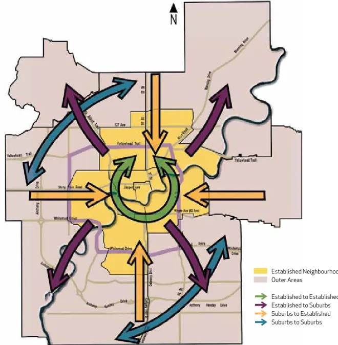
Edmonton residents make around 2.5 million trips on a typical fall weekday (an average person trip rate of 3.6 trips per day). Of these trips, 57% are made as a car driver, with the remaining trips being made by car passengers (20%), walking (11%), transit (9%) and cycling (1%) (Figure 3.1). Thirty-nine percent of weekday trips are made to commute to work or school (Figure 3.2). Trips occurring during the peak periods (7-9am and 4-6pm) represent over a third of all daily trips made, with the remaining trips spread throughout the day (Figure 3.3). The peak periods are important as there are a very high number of trips in a short period of time which dictate road capacity. However, the design of the transportation system, including transit service, also has to consider off peak trips, because the majority of trips occur in this time frame. As illustrated by Figure 3.4, 41% of all trips are made from Established Neighbourhoods to Established Neighbourhoods while 33% of trips are made between Established and Suburban Neighbourhoods.
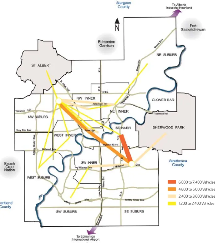
The Edmonton Region Commodity Flow Survey (2002) collected information on all goods and service vehicle movements generated by city and region businesses. Figure 3.5 shows the major movements of commercial vehicles between industrial areas within the city.
Figure 3.1 - How people travel
Figure 3.2 - Why people travel
Figure 3.3 - When people travel
Source: 2005 Edmonton Household Travel Survey, Daily Mode of Travel
Source: 2005 Edmonton Household Travel Survey, Daily Trip Purpose From Home
Source: 2005 Edmonton Household Travel Survey, Time of Travel
The AM peak period is from 7-9 am and the PM peak period is from 4-6 pm.
57% 20%
11%
9% 1% 2%
Car Driver (57%) Car Passenger (20%) Walk (11%) Transit (9%) Bicycle (1%) Other (2%)
13%
17% 17%
27% 26%
Work (26%) School (13%) Shopping (17%) Recreation (17%) Other (27%)
18%
67% 15%
AM Peak (15%) PM Peak (18%) Off Peak (67%)
Source: 2005 Edmonton Household Travel Survey
Note: These represent daily trips from home for all purposes by all modes. Established neighborhoods are those built before 1970.
52% of the population lives in the established Neighborhoods (2005).
Established neighbourhoods are equivlalent to mature neighbourhoods in The Way We Grow.
Established Neighbourhoods Outer Areas
Established to Established 41% Established to Suburbs 11% Suburbs to Established 22% Suburbs to Suburbs 26%
Figure 3.4 - Where people travel (Trip Destinations)
Figure 3.5 - 2002 Daily Good and Services Vehicle Trips within Edmonton
6,000 to 7,400 Vehicles 4,800 to 6,000 Vehicles 2,400 to 3,600 Vehicles 1,200 to 2,400 Vehicles
Current Environmental Trends
Climate Change
Climate change is one of the most pressing matters in the world today. Some of the key conclusions of the Intergovern-mental Panel on Climate Change Report Climate Change
(2007) were that:
• Most of the observed increase in globally-averaged temperatures since the mid-20th century is very likely due to the observed increase in anthropogenic GHG concentrations; and
• Continued GHG emissions at or above current rates would cause further warming and induce many changes in the global climate system during the 21st century that would very likely be larger than those observed during the 20th century.
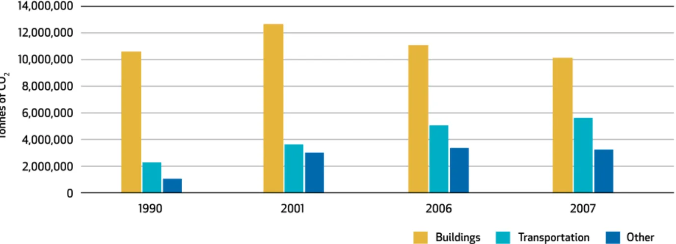
Greenhouse Gas (GHG) emissions consists of those gases that, once released into the atmosphere, absorb and emit thermal infrared radiation. These include water vapour, carbon dioxide, methane, nitrous oxide, ozone, hydrofluorocarbons, perfluorinated carbons, and halogenated fluorocarbons. Anthropogenic greenhouse gases are those that can be attributed directly or indirectly to human activity.
According to the City of Edmonton’s Corporate Environmental Scan, Edmonton is experiencing climate change along with the rest of the world. Edmonton’s anthropogenic GHG emissions have increased from 13.9 million tonnes in 1990 to 19.0 million tonnes in 2007, which equates to an increase of approximately 36%. This increase is greater than the rate of population growth. In addition, the proportion of emissions from transportation sources has been increasing since 1990, and in 2007 the transportation sector accounted for 30% of Edmonton’s anthropogenic GHG emissions, as shown in Figure 3.6. Ambient air quality depends on the balance between the rate that pollutants are emitted into the atmosphere, and the ability of the atmosphere to disperse them. It is a significant factor in respiratory health. The Air Quality Index is compiled by Alberta Environment and primarily considers non-greenhouse gas emissions, such as levels of particulate matter (10 and 2.5 µm), carbon monoxide, nitric oxide, nitrogen dioxide and ozone. Edmonton’s air quality has been good during the last ten years. In addition, the air quality impacts of the transportation sector in Alberta have been reduced since 1990. This is primarily due to widespread application of vehicle emission reduction technologies and advances in gasoline and diesel fuel technologies.
Source: EcoVision Annual Report 2008
Figure 3.6 Anthropogenic Greenhouse Gas (GHG) Emissions for Edmonton
14,000,000 12,000,000 10,000,000 8,000,000 6,000,000 4,000,000 2,000,000 0 Transportation
Tonnes of CO
2
Other
1990 2001 2006 2007
Future Transportation Demand
Future transportation demand will depend upon: • Demographic and geographic factors, including
population size and age, as well as where residents live, work and play (Figure 3.7);
• Economic and employment growth (Figure 3.8); • Transportation network supply and operating
conditions (Figure 3.9);
• Transportation policy, including cost of travel; and • Volatile fuel prices
The Strategic Goals, Strategic Objectives and Strategic Actions of The Way We Move were developed to consider these factors.
Demographic Factors
By 2040, the City of Edmonton’s population is expected to have grown by over 50% to approximately 1,150,000 people. The Capital Regional population as a whole is expected to have grown by about 60% to approximately 1.6 million people. As illustrated in Figure 3.7, significant population growth is projected in the 65+ age group. In contrast, less population growth is projected for children and youth.
In terms of percentages, children aged 0-14 years made up about one quarter (23%) of the population in 1987. This percentage had decreased to 19% by 2007 and is forecasted to decrease to 15% by 2040.
Currently, seniors aged 65 years and older make up 12% of the population, and are projected to represent 20% of the population by 2040. Specifically, the population of seniors 75 years and older has increased by 122% over the last 20 years. It is projected to further increase by another 80% by 2040.
Future Conditions
This demographic shift will have a significant impact on future travel patterns and associated transportation system requirements. As seniors make up an increasing proportion of the population, the transportation system will need to respond to their changing needs. Indications are that many seniors will continue to drive until they are medically unable to do so. As a result, the proportion of seniors who drive will increase. However, those seniors who do not drive or choose not to drive will require a range of public and private
transportation services. To allow seniors to age in place, that is to remain in their home or neighbourhood as long as they are interested in doing so, there are a number of key planning principles that should be implemented according to the report
Aging in Place: Promising Practices for Municipalities (2009). Some of these include:
• Diversify the housing stock available to seniors, • Promote mixed use development,
• Locate seniors housing close to facilities and services, • Provide for public transit that recognizes the
needs of seniors, and
• Encourage walkability by providing a pedestrian friendly walking environment.
Figure 3.7 - Edmonton Population by Age Profile
The financial sustainability of the transportation system will also be further stretched as a larger proportion of the population retire from working life, since income taxes paid to the provincial and federal governments are a major source of transportation funding.
Economic and Employment Growth
Figure 3.8 outlines the land development concept proposed by the Municipal Development Plan. Edmonton’s employment is projected to grow by more than 50% by the year 2040,
which is similar to the projections of population growth. Some of the larger employment areas within the Capital Region will be in the Alberta Industrial Heartland and Port Alberta (see Chapter 8 – Goods and Service Movement, Figure 8.2 - Regional Industrial Areas). Expansion of post-secondary education is also expected to contribute to future economic and employment growth.
If the current growth patterns continue, more than 80% of the population growth by 2040 is expected to occur outside of the established areas, while 75% of employment growth by 2040 will occur outside the established areas and industrial areas.
90,000 80,000 70,000 60,000 50,000 40,000 30,000 20,000 10,000 0
2006 Age Category
Number of P
ersons
2040
0 - 4 5 - 9 10 - 14 15 - 19 20 - 24 25 - 29 30 - 34 35 - 39 40 - 44 45 - 49 50 - 54 55 - 59 60 - 64 65 - 69 70 - 7
4
Figure 3.8 - Proposed Land Development Concept (MDP)
Map provided based on the Municipal Development Plan, The Way We Grow, Bylaw 15100 as of September, 2009. Please refer to current version of Bylaw 15100 for possible updates to map.
Central Core
Established Neighbourhoods Developing, Planned and Future Neighbourhoods
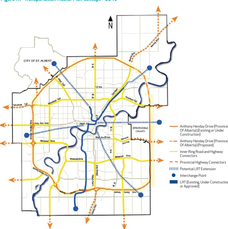
Industrial / Business Urban Growth Area Environment Restricted Development Area Inner Ring Road
Transportaion Utility Corridor North Saskatchewan River Valley and Ravine System
City Boundary This map represents a broad and conceptual illustration of the desired land development
structure and is not intended to provide site specific direction to land use regulations.
Figure 3.9 - 2040 Daily 2 way Vehicle Volume Increases from 2006
Figure 3.9 shows the anticipated increase in vehicle trafficvolume between 2006 and 2040. Anthony Henday Drive, although not complete today, is projected to be complete by
2016, and therefore shows a large increase in traffic volume over 2006. Yellowhead Trail, Whitemud Drive, the Inner Ring Road, and the Highway Connectors also carry a significant amount of the traffic growth.
Transportation Network Supply and Operating Conditions
Over 60,000 Vehicles 40,000 to 60,000 Vehicles 25,000 to 40,000 Vehicles 15,000 to 25,000 Vehicles 7,500 to 15,00 Vehicles
Note: Based on the Municipal Development Plan’s Proposed Land Use
Transportation Policy and Direction
Edmontonians are driving longer distances and dealing with increasingly congested streets. Automobile travel is increasing at a much faster rate than the rate of population growth: between 1994 and 2005, Edmonton’s population increased by 13% while the total number of kilometres traveled by automobiles (vehicle-kilometres) increased by 32%. The result is increased roadway congestion that impedes the efficient movement of people, goods, and emergency response services.
The transportation system is inextricably linked with land use policy. Vehicle kilometres traveled will consistently increase if the city continues to grow outwards in a suburban style. Edmonton’s suburban population has grown markedly over the last decade.
As a city grows outward, reliance on automobiles increases. Edmontonians living in suburban style developments are the least likely to take public transportation, as shown by City studies. This reliance on automobiles, combined with outward expansion of the city, means that people’s automobile trip lengths will become longer. The resulting cycle of increased kilometres traveled, road congestion, and the perceived need to build more roadways requires ever more taxpayer dollars for operation and maintenance, and is fiscally and
environmentally unsustainable.
In the Alberta Health Services report How Healthy Are We?
(2007), four major health risks associated with long trip distances and automobile dependence are identified - physical inactivity, air pollution, motor vehicle collisions and mental health. As increased time is spent commuting, daily opportunities for widely accessible and inexpensive forms of
exercise such as walking or biking decrease. Walking to work or shopping areas, sending children to school on their bicycles, or traveling to other destinations by bus or LRT are all made more difficult when distances are great because of low density neighborhoods, when streets are not well connected, or when public transit is less frequent.
Volatile Fuel Prices
As Edmontonians continue to rely on automobiles for their commute and drive longer distances, there is a risk associated with increases in fuel prices potentially arising from supply constraints associated with peak oil and/or the onset of a carbon pricing regimen. If the compounding cycle of increased kilometres traveled continues, Edmonton’s economic vitality may be affected by volatile fuel prices as citizens are forced to spend more to commute. Increasing and volatile fuel prices will also affect the financial sustainability of City operations if the vehicle fleet continues to use predominantly petroleum-based fuels such as gasoline and diesel.
4.0 transportation anD
lanD use inteGration
Background
Edmonton’s settlement pattern and urban form have always been influenced by its transportation infrastructure, including its river connections, railways, roadways, public transportation and airports. Transportation provides access to land, thereby affecting its desirability and value, while the mix and intensity of land uses results in activities that generate demands on the transportation system.
It is well recognized that major roadway and highway
investments tend to support and be consistent with a dispersed urban form and lower density development. Conversely, effective transit investments both rely on and help encourage more concentrated, denser and mixed use patterns of development. Continued growth of dispersed, low density land uses in Edmonton makes the provision of effective
The integration of transportation and land use supports
TMP STraTegic goalS:
• transportation and Land Use Integration
• Access and mobility
• transportation mode Shift
• Sustainability
• Health and Safety
• Well-maintained Infrastructure
• economic Vitality
MDP STraTegic goalS:
• Sustainable Urban Form
• Integrated Land Use and transportation
• Complete, Healthy and
Livable Communities
• Urban Design
• Supporting prosperity
• Natural environment
transit service very difficult and costly. The inability to effectively serve dispersed land uses has and continues to result in a high dependence on automobiles, as well as pressures to expand existing roads and build new ones. A major expansion of the LRT system is proposed to help move the city towards achieving the City Vision of becoming compact, healthy and sustainable. Land use policies and decisions to complement and support this system will be essential for success. Effective transit service along with transit oriented development will decrease the need for other public infrastructure investment throughout the Capital Region, and provide viable alternative transportation modes that will reduce Edmonton’s carbon and ecological footprint and lessen demand on energy and natural resources.
An integrated approach
to planning and developing the
transportation system and land
uses supports the creation of an
efficient, sustainable, compact and
vibrant city that maximizes the
effectiveness of its investment in
transportation infrastructure.
Building an integrated land use and transit system is key to managing the future growth of Edmonton. To accommodate future growth in a way that will enhance rather than degrade the region’s economy and appeal, the City of Edmonton can create higher density, mixed use developments in existing and future communities that are served by LRT, premium bus, or frequent, all-day bus service and make them better places to live and work (See Chapter 5 – Public Transportation for discussion of premium transit and premium bus service). The effective integration of land use and transit infrastructure requires mutually supportive land use, roadway, neighbourhood design and transit policies and actions. To that end, the City’s desired urban form, and the land uses used to define it, must be supported by a transportation network that reinforces the City’s broader economic, social and cultural objectives.
An Integrated Transit and Land Use Framework
An Integrated Transit and Land Use Framework focuses future higher density residential and employment growth toward transit corridors and station areas where it can be best accommodated by transit services and other public facilities. The integrated transit and land use approach provides direction for developing and redeveloping property based on the transit service provided, so that higher density developments are located where it is convenient for people to use transit. This approach promotes the creation of compact neighbourhoods with housing, jobs, shopping, community services, and cultural and recreational opportunities all within walking distance of convenient transit service. Integrating the planning and development of transit and land use creates well designed, livable, well connected, and environmentally sustainable communities where people can get from home to the office, grocery store, day care centre, restaurant, dry cleaner, library or park without using an automobile.
Planning efforts to support transit oriented communities include:
• Designing for public transportation initially, as opposed to fitting it in later.
• Encouraging a diverse mix of land uses at transit nodes and along transit corridors. This allows people to live and shop near their jobs, and leads to more balanced ridership levels and day-long transit use.
• Locating major trip generators (office towers, shopping centres, entertainment facilities, cultural centres, post-secondary education institutes, and major health care facilities) close to transit nodes and transit corridors. These facilities should be designed to be pedestrian friendly, bicycle friendly and compatible with transit. • Moderating the supply of parking at selected, higher
density trip destinations to encourage the use of transit and other alternative modes.
• Avoiding or minimizing land uses near transit nodes that are auto-oriented or that require significant amounts of parking.
The concepts of Smart Growth and Transit Oriented Development have been prevalent across North America for a number of years. The application of these concepts in Edmonton must however recognize the local Edmonton context and the reality that different parts of the city may require different approaches.
The land development pattern in Edmonton has a multitude of conditions. The types of projects that may be appropriate in older neighbourhoods, including their scale and density, are different from those that may work in newer areas.
The diversity of current development patterns, built forms, and levels of transit service requires the integration of transit and land use to be influenced by the local context. To provide general direction for development intensification, Edmonton can be divided into transit area types based on their geographic location, the type of land uses in the area, the type of transit service provided, and the built environment as defined below.
Integrating Transit with Land Use
4.1
• LRT Nodes – Areas served by existing and proposed LRT should have the highest land development intensities in Edmonton to achieve transit oriented development. Areas initially served by premium bus service as a precursor to LRT may be included in this category. Not all LRT Nodes are equal and development densities will vary between them due to the local context
of the station.
• Transit Centres – These are hub locations for bus routes in Edmonton that allow for transfers between routes. Similar to LRT Nodes, these areas benefit from their proximity to transit service, and as a result the development intensities surrounding them should be moderately high, leading to the creation of mixed use, complete communities that evolve to become important centres of activity.
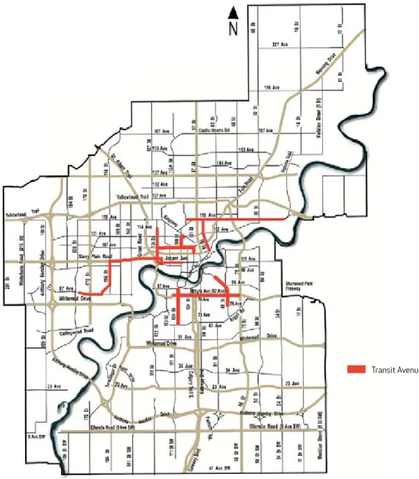
• Transit Avenues – There are linear corridors served by one or more bus routes that provide all day service and connect major trip generators, LRT stations, and transit centres. The bus routes serving these areas operate seven days a week with at least 15 minute frequency during weekday peak, and weekday, Saturday and Sunday midday periods. The land uses along these corridors are primarily oriented toward the street, allowing for redevelopment and intensification. Figure 4.1 illustrates the location of Transit Avenues in Edmonton. The areas along these corridors should intensify to moderate levels over time because they have dependable transportation options.
• Other Areas - All areas not meeting the LRT Node, Transit Centre, or Transit Avenue definition are defined as “Other Areas”. Other Areas include locations where the level of transit service is not great enough to be a factor in intensification of development, and where the street patterns, built environment, and existing land uses limit the potential for redevelopment or intensification. These areas should therefore not intensity to the same extent as areas associated with LRT Nodes, Transit Centres, or Transit Avenues.
Figure 4.1 - Transit Avenues
Transit Avenues
All the components that help shape urban form must be aligned for the City to reach its goals. As with transit, there is a need to develop roadway related policies and actions that support the city’s land use goals, and by extension, also support the transit policies and measures that are aligned with these land use directions.
Planning efforts to support appropriate land use and roadway integration include:
• Locating land uses and forms of development that are reliant on vehicle access to areas with appropriate and supporting roadway infrastructure; this would include areas of industrial and/or office park development that are highly dispersed, have high levels of free parking, serve commercial heavy vehicles and are inherently difficult and costly to serve with public transit. • Giving priority to roadway projects that support
enhanced transit operations and the movement of goods and services.
Integrating Roadways
with Land Use
4.2
• Designing transportation systems to ensure they are compatible and complementary to the surrounding land uses.
• Avoiding the construction or enhancement of roadways that would compete with or diminish the effectiveness of adjoining (parallel) transit infrastructure or service.
The integration of transportation and land use is more complex than simply placing the correct land uses around the appropriate transportation investments. It incorporates all the diverse elements of community building that influence land use and transportation infrastructure in the overall urban fabric.
Land Use and Community Character
The creation of a sustainable community involves a mix of land uses as well as land use features and design elements that promote the development of walkable communities.
Community Building
4.3
Transportation Mobility and Access
Transportation facilities should be designed for the movement of goods and people, balanced by the need to design the transportation system to fit with the surrounding or desired land use context and the need to support
development opportunities. Neighbourhoods should be designed to encourage community-friendly traffic behaviour, such that speeding and shortcutting are discouraged.
Parks, Public Spaces and Civic Infrastructure
Parks and civic infrastructure are community investments that have a significant impact on adjoining land uses. A system that considers transportation infrastructure to a greater extent than the current system will be necessary to develop livable, transit-friendly communities. Frequency of use, public safety and public acceptance of parks, public spaces, cultural and recreational facilities and civic infrastructure increases significantly when access and visibility is improved, and the surrounding land uses encourage use throughout the day.
Regional Context
Strategic Objective
4.1 the City will integrate land use planning and transportation decisions to create an accessible, efficient and compact urban form.
Strategic Actions
a. Developing integrated transit and land use guidelines.
b. encouraging land uses that are compatible and complementary to the surrounding transportation network.
c. Designing the transportation network to ensure it is compatible and complementary to the surrounding land uses.
d. Locating business employment areas relying heavily on goods movement in the vicinity of the Inner ring road, Anthony Hendy Drive or Highway Connectors.
e. Working with regional partners to implement complementary policies in adjacent
municipalities and in the Capital region plan.
Economic Development and Development
Incentives
The City has the ability to encourage, provide incentives and potentially share risk with private developers to create desired patterns of development. Economic development and development incentives play a critical role in shaping the pattern of development in Edmonton and placing demands on the transportation system.
Coordination of land use and transportation decisions within the City of Edmonton will affect Edmonton’s urban form. If similar policies are implemented in the entire Capital Region the effectiveness of transportation and land use policies will be maximized.
5.0 public transportation
A comprehensive public transportation system supports
a sustainable, livable city where more people use transit
as a preferred transportation choice.
A comprehensive public transportation system supports
TMP STraTegic goalS:
• transportation and Land Use Integration
• Access and mobility
• transportation mode Shift
• Sustainability
• Health and Safety
• economic Vitality
MDP STraTegic goalS:
• Sustainable Urban Form
• Integrated Land Use and transportation
• Complete, Healthy and
Livable Communities
• Urban Design
• Supporting prosperity
• Working within our region
Background
Public Transportation is a cornerstone of Edmonton’s transportation system. Edmonton’s strong economy and population growth will continue to exert significant pressure on the city’s transportation system, civic infrastructure and public services. Growing environmental and energy concerns make the development and expansion of the existing public transportation system paramount. Indications are that Canada has a great opportunity to support a shift to sustainable transit options for a variety of reasons. Canadians are saying that they want better transit to create better communities and to help cope with increasing gas prices, other significant costs associated with vehicle ownership, and increasing traffic congestion.
The Transportation Master Plan places an emphasis on developing and expanding the existing public transportation system while capitalizing on new opportunities for public transportation within the greater Edmonton area.
To make public transportation the preferred choice of more people, Edmonton must make a series of major improvements to the transit system as well as to its physical, social and economic context. A comprehensive public transportation system is the key to achieve the City’s Vision and Strategic Goals. The importance of public transportation in city building is recognized in The Way We Grow chapters “Managing Growth,” “Complete, Healthy and Livable Communities” and “Urban Design.”