2018 International Conference on Computational, Modeling, Simulation and Mathematical Statistics (CMSMS 2018) ISBN: 978-1-60595-562-9
The Positioning Performance Simulation Analysis of BeiDou-2
and GPS in the Arctic Region
Hou-pu LI
1*, Qing-hui TANG
2and Hai-feng ZHANG
31Department of Navigation, Naval University of Engineering, Wuhan, China
232022 Troops, Wuhan, China
3 92987 Troops, Hezhou, China
*Corresponding author
Keywords: Beidou-2; GPS, the Positioning performance, the Arctic region, STK.
Abstract. In order to master the positioning performance of BeiDou-2 and GPS in the Arctic region, the “5 GEO+5 IGSO+ 4 MEO” BeiDou-2 and “24 MEO” GPS using STK software is simulated. Based on this simulation, the satellite visibility, GDOP value and navigation accuracy in the Arctic region such as Yellow River Station (78.92° N and 11.93 ° E), Rick station (64.15°N, 21.57°W) and a third station are systematically analyzed. The results show that BeiDou-2 could not provide continuous and reliable service in the Arctic, while GPS has better performance.
Introduction
The development of Chinese navigation satellite system follows the “three step” strategy, that is, “the demonstration system, the regional system, and the global system” (Yang et al, 2014). The regional system is also called as BeiDou-2 Satellite Navigation System, which has been successfully established on October25, 2012. With global warming, the Arctic sea route from the Arctic Ocean to the Atlantic and the Pacific will eliminate the threat of sea ice and iceberg, and is expected to become the future of a major strategic significance of the golden channel. Arctic region contains rich resources, and its great commercial value and scientific research value has become the new focus of attention of the international. It has very important value in military strategy. The people who controls over the Arctic obtain the commanding height of the military, will have a significant impact on the entire northern hemisphere and global military posture, thus greatly influence the world pattern. So it is very important to master the positioning performance of the BeiDou-2 and GPS satellite navigation systems in the Arctic region.
Some researchers have done a lot of work about the satellite visibility and GDOP (Geometric Dilution of Precision) of BeiDou-2. But little work has been done about BeiDou-2 in the Arctic region .In this paper, the STK10.0 software is used to simulate the BeiDou-2 and GPS systems, and the visibility, navigation accuracy and geometric precision of the system are analyzed in detail.
The Simulation of BeiDou-2 and GPS Constellations
Figure 1. The three-dimensional scene of beidou-2 constellation.
Figure 2. The three-dimensional scene of GPS constellation.
The positioning performance comparison of BeiDou-2 and GPS in the ArctIC Region
The satellite visibility, navigation accuracy and GDOP, are often used to indicate the positioning performance, which could help us master the positioning effect and provide reference for the practical application. These can be obtained using “Coverage Definition” and “Figure of Merit” modules in STK.
Assuming the simulation time is from 4 o´clock 21 April
2016 to 4 o´clock 22 April 2016, Yellow River Station (78.92° N and 11.93 ° E), Rick station (64.15°N, 21.57°W) and a third station (85 ° N, 30 ° E) are chosen as the typical regions. The satellite elevation mask angle is set as 15 degrees.
The Comparison of Satellite Vvisibility
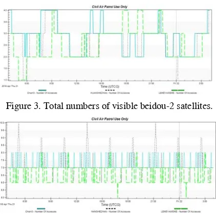
[image:2.612.197.413.194.301.2]Figure 3. Total numbers of visible beidou-2 satellites.
[image:3.612.200.413.325.405.2]Figure 4. Total numbers of visible GPS satellites.
Table 1. The comparison of total numbers of visible beidou-2 and GPS satellites.
Systems BeiDou-2 /GPS
Stations Min Max Mean
Yellow
River 1.0/6.0 4.0/10.0 2.7/7.2 Rick 2.0/5.0 4.0/.08 2.5/6.6 3rd 2.0/7.0 4.0/8.0 2.9/7.3
From Figure 3, Figure 4 and Table 1, one could find that the visible satellites of BeiDou-2 are no more than 4 satellites and much less than that of GPS, which means that BeiDou-2could not accurately calculate the user’s position.
The Comparison of GDOP
[image:3.612.200.409.507.604.2]The GDOP variation of BeiDou-2 at the three stations is shown in Figure 5. The statistics of GDOP values of BeiDou-2 and GPS are listed in Table 2.
[image:3.612.198.414.640.720.2]Figure 5. The GDOP variation of Beidou-2.
Table 2. The comparison of GDOP values of Beidou-2 and GPS.
Systems BeiDou-2 /GPS
Stations Min Max Mean
Yellow
From Figure 4 and Table 2, one could find that the mean GDOP value of BeiDou-2 is bigger than 8, twice as that of GPS. The maximum GDOP value of BeiDou-2 is bigger than 20, which is too big to be used.
The Comparison of Navigation Accuracy
The navigation accuracy variation of BeiDou-2 in the Arctic region is shown in Figure5, and that of GPS at the three stations is shown Figure 6. The statistics of navigation accuracy of BeiDou-2 and GPS are listed in Table 3.
[image:4.612.201.413.170.267.2] Figure 6. The navigation accuracy variation of Beidou-2.
Figure 7. The navigation accuracy variation of GPS.
Table 3. The comparison of navigation accuracy of Beidou-2 and GPS.
Systems BeiDou-2 /GPS
Stations Min Max Mean
Yellow
River 33.5/6 102.5/10 45.8/7.2 Rick 19.8/10.2 120.6/55.9 43.1/18.9
3rd 21.6/13.0 227.9/24.8 67.8/20.3
From Figure 6, Figure 7 and Table 3, one could find that the mean navigation accuracy of BeiDou-2 at the three stations is lower than 40m, and that of GPS is higher than 20m. The maximum navigation error of BeiDou-2 is bigger than 200m, which is too big to be used.
Summary
Constellations of BeiDou-2 and GPS are simulated using STK. The visibility, GDOP and navigation accuracy of BeiDou-2 and GPS are analyzed in the Arctic region. Results show that the big dipper in the arctic area system is not able to provide a continuous positioning services, while GPS can provide continuous and reliable positioning service.
Acknowledgment
References
[1] Y.X. Yang, J.L. Li, A.B. Wang, et al. Preliminary assessment of the navigation and positioning performance of BeiDou regional navigation satellite system. Science China: Earth Sciences, vol. 57, pp. 144-152, 2014.
[2] Yang Y.X. Progress, contribution and challenges of COMPASS/BeiDou satellite navigation system. Acta Geodaet et Cartograph Sin, vol. 39, pp. 1-6, 2010.
[3] Montenbruck O., Hauschild A., Steigenberger P., et al. Initial assessment of the COMPASS/BeiDou-2 regional navigation satellite system. GPS Solutions, vol. 17, pp. 211-222, 2013.