Abstract— Even in highly developed western regions, huge
riveraine floods are a great challenge for flood response management. The cooperation of different response authorities and organizations under time critical conditions in a highly dynamic environment require support with modern IT methods and systems. Present Flood Information Systems still do not sufficiently focus on supporting the workflow of planning and carrying out flood response actions. This paper introduces a new process centric approach, which improves the coordination and information workflows of Emergency Operation Centers (EOC) and involved services. Formal process models as core of a process driven emergency management platform provide the responsible agent with appropriate data and analyses along defined emergency processes. The platform guides the EOC officers and involved parties through the organizational steps of flood response actions. Coordinated information flow and automatic multi-channel notifications are ensured throughout the process. The developed approach is successfully validated using flood scenarios with real-world data. The results show that the approach improves information flow in the EOC and to external organizations and enhances coordinated work-sharing of EOC team members during flood response
Index Term— process models; emergency management
system; flood response; webGIS
I. MOTIVATION
The huge floods in Pakistan and Australia in 2010 attracted the worldwide attention to that type of natural disasters. In May and June 2013 heavy rains led to extreme flooding in Central Europe comparable to the Elbe flood 2002. Floods remain one of the major natural disasters which cause high damage of property (e.g. in Germany 2002: 11 billion Euros, 2013: 6,7 billion) and may also threaten human lives. Although great efforts in reducing the risk of floods have been undertaken, a hundred percent protection is never possible. Therefore, flood response management is of capital importance. Flood response management is characterized by a
Armin Wagenknecht, Dr.-Ing; Institute of Numerical Methods and Informatics in Civil Engineering, Department of Civil Engineering and Geodesy, Technische Universitaet Darmstadt, Petersenstrasse 13, Darmstadt,
D-64287, Germany, PH (+49) 6151-163444, FAX (+49) 6151-165552; [email protected]
Uwe Rueppel, Prof. Dr.-Ing.; Institute of Numerical Methods and Informatics in Civil Engineering, Department of Civil Engineering and Geodesy, Technische Universitaet Darmstadt, Petersenstrasse 13, Darmstadt,
D-64287, Germany, PH (+49) 6151-163444, FAX (+49) 6151-165552; [email protected]
complex environment. Various organizations and public authorities have to carry out response operations together under exceptional, time-critical conditions [1,2]. At the time disasters occur, firstly the municipalities have to cope with these conditions.
In order to supply the Emergency Operation Centers (EOC) of municipalities with up-to-date information about the site, resources, action forces etc., Flood Information Systems are more and more used by the authorities. These systems provide aggregated information using databases and geographical information systems [3].
However, German after-flood reports have revealed missing support for the coordination of planning and carrying out flood response actions [4,5]. Poor information exchange in and between established EOCs as well as ambiguous emergency procedures led to inefficient resource management and constrained flood response actions. Actions as evacuation or dike defense consist of many individual activities which have to be planned and coordinated by the EOC officers. Similar problems in communication, data sharing and collaboration are described by Foltz and Brauer for disaster response in the US [6].
Today´s Flood Information Systems focus on providing forecast and field information. But they neglect the support of coordination and information workflows in terms of guiding EOC teams in carrying out the necessary steps to orchestrate flood response actions.
Therefore, this paper presents a new process centric approach to support flood response management adapting process management methods of information technology research. In order to validate the benefits of this research work, the results have been evaluated with flood scenarios using real-world data of our partners: public authorities and engineering bureaus.
This paper is structured as follows. In Sect. II related international work to the research subject is discussed and in Sect. III the scope and limitations of this work are described. Then procedures and information needs in flood response are analyzed in Sect.IV. In Sect. V the new approach of process driven emergency management in flood response is presented. Following to that Section, developed process models and the platform for process driven emergency management are described in Sect. VI. Findings and a validation of the research
Process Driven Emergency Management
Platform for Flood Response Integrating web
GIS Technologies
approach are given in Sect. VII. Finally, Sect. VIII gives a conclusion of the research work.
II. RELATED RESEARCH WORK
Early research activities in the US proposed to apply process management technologies to support coordination work and information flow in disaster situations [7]. Mak et al. pointed out the benefits of these technologies to support emergency activities after nuclear incidents and developed basic process models [8]. The approach presented in this paper, goes beyond these activities. More sophisticated models with conditional branches, parallel processes and sub processes are developed. This is strongly needed in order to model complex disaster scenarios as the basis for process-steered coordination and information support for EOC personal.
The European research project ERMA (Electronic Risk Management Architecture) developed process models, e.g., for the emergency activities of a toxic cloud incident in harbor facilities. The project focused on intuitive modeling and visualizing emergency processes in order to better analyze and improve emergency activities [9]. In ERMA, it remains unsettled how far these process models are suited to be executed by a process management system in order to steer information flow and provide EOC staff with analyses and decision support. These aspects are profoundly treated in our approach which is introduced in this paper.
Other approaches enhance Petri nets for modeling emergency processes and cross-organizational workflows, which enables a formal representation because of the mathematical foundation of Petri nets [10,11,12]. The developed processes models in our work also base on a formal representation but further combines them with concepts of highly configurable process components, e.g., for map-based decision support, which is neglected in the Petri nets approaches. Nevertheless, the question, how to combine both approaches is one challenge for future research work.
In the context of the practice-oriented European research project NOAH, the Flood Information System FLIWAS has been developed [13]. The system mainly serves as web information platform for municipalities and also provides basic workflow functionalities for routine actions in the run-up to severe flood events. Depending on defined river water levels, process activities are triggered which inform emergency services to start countermeasures as e.g. the clearance of parking lots in riverside streets. The project strongly shows the need for process management methods in flood response, but it only deals with models for basic sequential workflows. In contrast, our approach transforms the complex information flow and tasks of large scale evacuations and of multi-organizational resource management in formal process models to better orchestrate flood response actions. Finally, within the framework of the European project WORKPAD, a specialized process management system with corresponding process models has been developed to steer and control the assignment of tasks to several field rescue teams on their mobile devices [14]. Therefore emergency tasks can be predefined through short process models and can be executed and assigned to teams during the disaster incident.
As WORKPAD focuses on the field personal it lacks support for the processes in and between Emergency Operation Centers, which is crucial for a centralized orchestrated disaster response. Hence, this subject forms the core of our research work.
III. SCOPE AND LIMITATIONS OF THIS WORK
Our research work focuses on supporting the coordination and the information workflows of Emergency operation centers in flood response. For this purpose we developed a new approach in combining process management technology with web based GIS-modules and flood simulation services. This approach allows an exact, process-controlled information flow and steering of flood response actions, automatically considering results of operational flood simulation in the processes. Our approach focuses on the application domain of flood response and does not discuss the IT-support for the management of other types of natural or man-made disasters. Though, parts of our research results also generally contribute to disaster management, as evacuation coordination and resource management represent general challenges of disaster management.
Furthermore, contribution to IT-support for field personal and related technologies as location based service, wireless ad hoc networks and mobile applications are not in scope of our research work.
IV. ANALYSIS OF PROCEDURES AND INFORMATION NEEDS IN FLOOD RESPONSE
A process centric IT support for Emergency Operation Centers requires a clear representation of the processes of flood response actions. Therefore, we have studied flood response literature, regulations as well as after-crisis reports and we conducted interviews with disaster managers to derive these processes.
In our research we focused mainly on two highly coordination intensive activities in flood response: large-area evacuations and the management of resources as vehicles, equipment and material of different organizations [15].
Fig. 1. excerpt of evacuation process
The main part of process activities of emergency resource management and of organizing large scale evacuations highly depends on geographical data and analyses. For instance, it is crucial to the activity which determines transport routes, to know, which streets are already flooded, respectively, which one will be flooded during the next hours. The other great part of analyzed process activities are those which provide involved emergency services with information of precedent planning activities of the EOC. In order to leverage the coordination, the output of the planning activities should be automatically delivered to the appropriate emergency services. With the documented BPMN processes of large scale evacuation and multi-organizational resource management as well as with the IT requirements of the different process activities we developed the new approach of a process driven emergency management for flood response.
V. NEW APPROACH OF PROCESS DRIVEN EMERGENCY MANAGEMENT FOR FLOOD RESPONSE
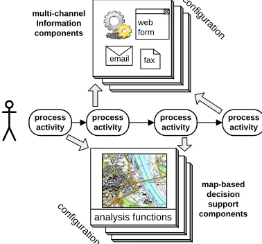
The main goal of the process driven emergency management is to guide the EOC officers and involved emergency services through the organizational steps of flood response actions. Within each step, the responsible agent is provided with the appropriate data and analyses. Furthermore, the process driven emergency management coordinates the information flow among these steps respectively activities and ensures the notification of involved emergency services throughout the process.
Therefore we developed formal process models of flood response actions (see Sect. IV.C) which are embedded in a process driven emergency management platform (see Fig. 2). These process models are derived of the conceptual BPMN processes which were introduced in Sect. II. The process models define the response actions and link them with decision support and information components for EOC members to handle these actions.
Fig 2. concept of a process driven emergency management platform
The emergency management platform technically provides the following components: automatic multi-channel information to and from emergency services (left part of Fig. 2) and decision support on the basis of geographical analyses of the flood and the relief situation (right part of Fig. 2).
In order to integrate external emergency services in the coordination and information workflow of EOC, process activities trigger multi-channel information components. These components perform notifications and requests to appropriate emergency services using different channels (email, fax and generated websites).
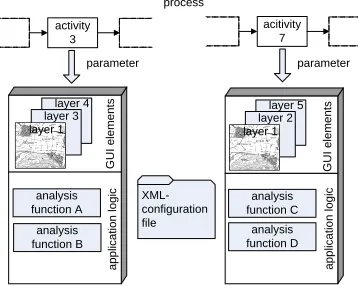
The map-based decision support components provide situational geographical data as well as analyses functions. Data consists, e.g., of locations of flood response actions, the location of resource depots and of evacuation meeting points. Analysis functions, e.g., provide route calculation considering inundated areas as well as predicted flood areas delivered by dike break simulations. These components are invoked by process activities of the flood response process models. The components configuration defines which data and analysis functions are provided for the specific process activity (see Fig. 3).
Fig 3. activity specific configuration and invocation staff section
warning and information
staff section transportation staff section command staff section traffic management staff section accommodation staff section care determine meeting points identify/ select evacuation shelters define transport routes determine needed transportation capacity determine needed capacity for shelter define warning
message
choose type of warning start diaphone warning warning by broadcast warning with sound trucks
determine need for supply goods at emergency shelters contact emergency
services for availabe resources contact transportation services transportation planning instruct transportation services inform police of
transportation routes to block streets and
control traffic determine vulnurable public facilities inform administration
instruct care services determine need for care
at emergency shelters organize medical care
determine resources for meeting points
determine endangered private
facilities
inform operator
contact care services contact emergency services
schedule care personnal
Maßnahmen der Evakuierungsdurchführung staff section
warning and information
staff section transportation staff section command staff section traffic management staff section accommodation staff section care determine meeting points identify/ select evacuation shelters define transport routes determine needed transportation capacity determine needed capacity for shelter define warning
message
choose type of warning start diaphone warning warning by broadcast warning with sound trucks
determine need for supply goods at emergency shelters contact emergency
services for availabe resources contact transportation services transportation planning instruct transportation services inform police of
transportation routes to block streets and
control traffic determine vulnurable public facilities inform administration
instruct care services determine need for care
at emergency shelters organize medical care
determine resources for meeting points
determine endangered private
facilities
inform operator
contact care services contact emergency services
schedule care personnal
The configuration of the components allows reuse for multiple activities of the flood response process models and at the same time it provides the EOC officers only with needed functionalities and data visualization for process activity execution.
The next section describes the process models and the platform which realize the presented approach.
VI. PROCESS MODELS AND PLATFORM FOR PROCESS DRIVEN EMERGENCY MANAGEMENT
A. Design principles and technical methods
The processes of flood response management we have analyzed contain mainly activities which are performed by people interacting with others and with support tools. Therefore we have applied a human centric process management system (PMS) for our approach (for further definitions of human centric and system centric process management systems see [19,20]). The PMS Aristaflow results of longtime academic research at University of Ulm [21]. For the following reasons we have chosen Aristaflow: formal process modeling language with visual modeler; correctness of process flow and data flow is checked simultaneously to the construction of the process models; interfaces for a flexible adaption of software components. We have configured the Aristaflow components for our needs and we have embedded it in our platform. The architecture using the Aristaflow process engine is depicted in Fig. 4.
Fig. 4. technical platform architecture
The formal process models for multi-organizational resource management and large scale evacuations are stored in the process repository and are executed and managed by the process engine. Decision support components for process activities are realized through a highly configurable webGIS, which we have developed, in combination with interfaces to geo services for flood response. Geographical working data for analysis and visualization is stored in a geographical database. These components, the developed formal process models as well as the interplay of processes and components are detailed in the following. Further descriptions of the components for multi-channel information as well as of the organizational EOC-model are out of scope of this paper.
B. Map-based decision support for flood response processes The map-based user interface is realized as a process-aware webGIS which provides interfaces, data and analysis functions customizable to each process activity needing a map-based
decision support. Therefore the webGIS consists of independent modules which encapsulate different application functions. These modules process geographical data analyses for flood response via accessing geo services and the geo database.
A configuration file defines for each map-based process activity the modules and user interface elements of the webGIS which are invoked by the process engine during the execution of the flood response process models (see Fig. 5).
Fig. 5. process invocation of webGIS modules
In our analysis of the processes and information needs of resource management and evacuation we inter alia identified the need of forecast information on flooding due to dike breaks and the need of routing calculation to determine transport and evacuation routes.
Hence, we exemplarily have integrated geo services providing geographical analysis and simulations for these use cases in the modules of the process-aware webGIS. The dike break simulations are calculated with FloodArea [22] which can run on a computer cluster to allow a fast simulation of dike break scenarios for operational purposes. As this product does not deliver the simulation results as a service we implemented an OGC-conform geo service [23]. Furthermore, we integrate the internet route calculation service ―OpenLS route service‖ from University of Bonn [24] in the webGIS modules to dynamically perform route calculations from potential resource depots to flood defense locations as well as from meeting points to evacuation shelters. In order to consider in the route calculation the expansion of inundated areas, which are impassable for vehicles, we have chained the two geo services in the webGIS modules as it is simplified illustrated in Fig. 6.
Fig. 6. service chain for calculation of water-free routes «component» Aristaflow PMS «component» OGC-service routing OGC-service «component»
process web client «artifact»
process model of evacuation
«artifact» process model of resource management
«artifact» organizational model EOC
«component» process engine
process repository
«use»
«use»
«use»
«component» dike break simulation
(FloodArea) «components»
multi channel information
flood response data (PostGreSQL/ PostGIS) «component» process-aware webGIS (UMN Mapserver, PHP, Axis2-Services) «component» simulation results service call activity 3 process acitivity 7 XML-configuration file parameter parameter a p p lic a ti o n l o g ic G U I e le m e n ts layer 4 analysis function A layer 3 a p p lic a ti o n l o g ic layer 1 analysis function B analysis function C analysis function D G U I e le m e n
ts layer 5
layer 2 layer 1 calcuate route webGIS routing WFS dike break inundation
forecasts
route service
GetFeature(inundated areas)
inundated areas
RouteRequest(start, end, inundated areas)
RouteResponse(time, distance, route geometry, description) route request
The webGIS module for routing receives a route request and therefore retrieves the forecasted inundated areas from the dike break simulation service. These parameters are passed to the route service which returns the route description. The service chain is called iteratively for one route calculation to consider the expansion of inundation over time. Alternative fast response flood simulation tools as presented by Judi et al. could also be used, as far as they provide suitable, stable interfaces [25].
The following subsection explains the developed formal process models which represent the core of our conceptual research work. They form the basis for the orchestration and invocation of the different platform components.
C. Formal process models for flood response
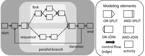
We developed formal process models which describe the individual process activities, their temporal and logical relations as well as who performs these activities using which platform component. Therefore we have used the formal process modeling notation provided by Aristaflow which is depicted in Fig. 7 [26].
Fig 7. elements of Aristaflow process notation
The main modeling elements are activities which are connected by edges. Besides modeling sequences, the notation allows to model iteration loops, parallel branches (with and-joins and –splits) and forks (with or-and-joins and –splits). For each iteration or fork, a condition has to be set which is checked at the time the process is running in order to decide to loop or respectively to decide which branch to execute.
The developed process model for multi-organizational resource management is shown in detail in [15]. This is why in this paper we focus on the process model for large scale evacuations.
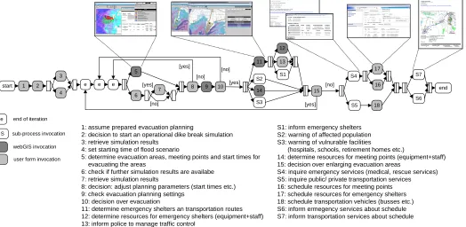
The developed process model with activity descriptions is depicted in Fig. 8. The evacuation process can be started by the EOC team during a severe flood event at the time the risk for dike breaks along the river passes a certain threshold depending on predicted and measured water levels.
In the first part, the process allows to choose a pre-calculated evacuation scenario as basis for the evacuation and to refine it with operational dike break simulations results along the evacuation process (activities 1-4, 6, 7, 8). Then important organizational steps are executed by the EOC officers, as the determination of evacuation areas, meeting points, emergency shelters and evacuation routes (activities 5, 9-12). At the time, where information about the evacuation details is available, the different stakeholders are automatically informed (activities 13, S1-S3). Furthermore, needed resources (staff and equipment) are determined (activities 12, 14), availabilities are checked (activities S4, S5), resources are scheduled and the affected services are supplied with information for delivering the resources (activities 16-18, S6, S7). Back loops allow for adjusting the evacuation planning, e.g., to enlarge the evacuation areas.
Either webGIS modules (dark grey activities) or generated user forms (light grey activities) are invoked, depending on the characteristics of information and platform interaction, needed by the EOC officers. A sub process activity summarizes activities of an underlying process which is traversed multiple times (e.g., in S1 each emergency shelter is provided with individual information on the amount of expected people and the estimated space of time for arrival). A detailed description of the seven sub processes is out of scope of this paper.
In the next section we describe sample activity implementations of the evacuation process in more detail to demonstrate its practical application by EOC staff during flood response.
Modeling elements
OR-SPLIT
OR-JOIN
AND-SPLIT
AND-JOIN
activity control flow (edge) parallel branch
fork
sequence
iteration
Fig. 8. process model for large scale evacuation
D. Sample implementations of process activities
After the execution of dike break simulations, activity 5 of the evacuation process is started by the EOC officer. The platform invokes the associated webGIS modules which provide the needed data and functions to determine evacuation areas, meeting points and also to define start time for evacuating each endangered area (see Fig. 9). The webGIS displays recommendations for these planning parameters on the basis of the temporal and geometrical water progression forecasts of the preceding dike break simulations. The EOC officer may verify and adjust these parameters and then finish activity 5 so that the platform passes the data on to the following process activities.
Fig. 9. determination of evacuation areas, meeting points, start times
In activity 11 webGIS modules are invoked which allow the determination of evacuation shelters to which the people of the evacuation areas shall be carried by busses. Once the responsible EOC officer has chosen emergency shelters, the
meeting point and transportation time. Only secure routes according to the transportation duration are suggested by the webGIS, as the right route shown in Fig. 10.
Fig. 10. water-free route during transportation duration to evacuation shelters
Needed resources at meeting points and emergency shelters as well as transportation means can as well be determined with webGIS modules of the corresponding process activities. These needed resources are automatically inquired at the emergency and transportation services by the multi-channel information components (see Fig. 3). For instance, in sub process S4 emergency services are notified by email or fax, which resources are needed and they can report available resources over generated web forms to the platform as it is depicted in Fig. 11.
start 1 2
4 3
e e e
5
6 7 [yes]
[no]
8 9 10 [yes] [no]
11
14 12
13
15 S2
S3
S1 S4
16
S5 18
17
S7
S6 end [yes]
[no] [no]
[yes]
e end of iteration
S sub-process invocation
webGIS invocation
user form invocation
1: assume prepared evacuation planning
2: decision to start an operational dike break simulation 3: retrieve simulation results
4: set starting time of flood scenario
5: determine evacuation areas, meeting points and start times for evacuating the areas
6: check if further simulation results are availabe 7: retrieve simulation results
8: decision: adjust planning parameters (start times etc.) 9: check evacuation planning settings
10: decision over evacuation
11: determine emergency shelters an transportation routes 12: determine resources for emergency shelters (equipment+staff) 13: inform police to manage traffic control
S1: inform emergency shelters S2: warning of affected population S3: warning of vulnurable facilities
(hospitals, schools, retirement homes etc.)
14: determine resources for meeting points (equipment+staff) 15: decision over enlarging evacuation areas
S4: inquire emergency services (medical, rescue services) S5: inquire public/ private transportation services 16: schedule resources for meeting points 17: schedule resources for emergency shelters 18: schedule transportation vehicles (busses etc.) S6: inform ermegency services about schedule S7: inform transportation services about schedule
time 2: route blocked; transportation duration too long
Fig. 11. email notification and web form to report resources
Reported resources and transportation means are later scheduled for the meeting points, evacuation shelters and the evacuation routes. Fig. 12 shows the user form which is invoked in activity 17 to schedule resources of emergency services for evacuation shelters.
Fig. 12. assignment of available resources to evacuation shelter
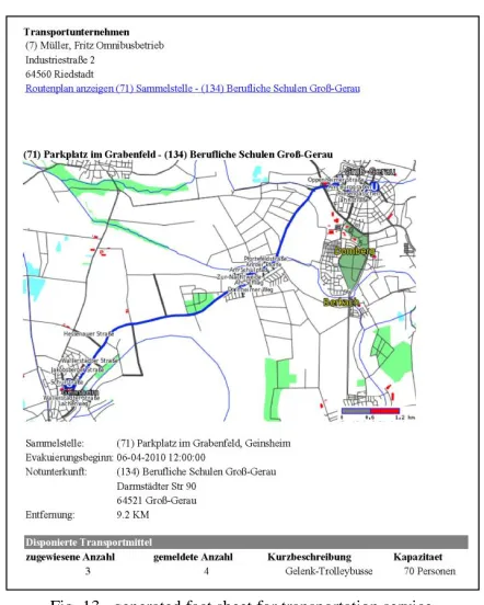
At last, several activities of the evacuation process provide functionalities to warn and to inform stakeholders as emergency services, the population, vulnerable facilities and transportation services. Therefore, multi-channel information components allow assembling geographical map information with textual information specific to the recipient. The assembling and sending is automatically processed in the corresponding process activity. For instance, an evacuation fact sheet with assigned routes, times and destinations is generated for each transportation service and send by email and fax (see Fig. 13).
Fig. 13. generated fact sheet for transportation service
VII. FINDINGS AND VALIDATION OF THE APPROACH We have implemented a riveraine flood scenario with real emergency response data and geographical-hydrological data for a pilot Region at the Rhine River in order to validate the developed models and methods in practice. In detail, we assumed a 250-year flood which affected two counties (Bergstrasse and Gross-Gerau) in the Frankfurt region. In our scenario the flood causes several dike breaks which were simulated with the FloodArea software. All emergency response data has been taken of the districts contingency plans, e.g., vulnerable facilities, transportation means and population data. In co-operation with the districts departments of disaster control and their emergency operation centers (EOC) we have analyzed the results achieved with the developed methods and process models which are technical represented in the process driven emergency management platform. The professionals pointed out the following findings:
the approach significantly improves the information flow in the EOC and with external stakeholders the provision of EOC officers with appropriate task
depending support and emergency information makes work-sharing more effective
the provided functionalities of process-controlled assignment and information of emergency services and involved organizations makes flood response more effective
the process models and the platform can successfully cope with crucial real world emergency response processes and data
However, the professionals remarked the following technical generated email with hyperlink to web form
guaranteed; intensive training of EOC personnel is crucial for the implementation of the developed methods and process models in practice.
VIII. CONCLUSION
The complex and challenging response to huge riveraine floods is still insufficiently supported. Mainly appropriate methods and corresponding information technology systems are missing which support and improve the coordination and information workflows of EOC teams to orchestrate flood response actions.
Therefore, we have developed a new approach of a process driven emergency management with formal process models, which we have successfully validated using flood scenarios with real-world data in co-operation with flood response professionals.
The process driven emergency management orchestrates the information support in each step of flood response actions and provides the responsible EOC officer and involved emergency services with the appropriate data and analyses. The platform steers the information flow on the basis of developed formal process models which consider temporal and functional dependencies between the tasks which have to be performed by the EOC personnel. Assignments and notifications of involved emergency services are included in the models and are performed automatically using different information channels.
Hence, the presented new process centric approach strengthens guidance of EOC personal in flood response and improves coordination and information supply of involved parties. Therefore this work makes an important contribution to a more effective preparation and response to flood disasters in order to reduce damages to persons and property in the future.
In order to achieve yet more flexibility in process support for emergency management, further research should focus on supporting dynamic changes of running process models for flood response. Process management system technologies which in principle support ad hoc changes of processes are evolving. Further research in this domain has to face the challenge that greater flexibility in process support must not lead to greater complexity for the users of the system – emergency personal which has to cope with exceptional circumstances under high pressure of time.
ACKNOWLEDGEMENTS
The research project was funded by the German Research Foundation. We would also like to thank our partners, the districts department of disaster control of Heppenheim and the environmental engineering bureau BGS Umwelt for their knowledgeable support.
REFERENCES
[1] Heuer L., Flikweert J.-J., Hoogendoorn D., Ligthard N. (2006). ‖Residual risk revisited – flood incident management in the Netherlands‖ Proc., Defra Flood and Coastal Management Conference in York, England.
[2] Auf der Heide E. (1989). „Disaster Response: Principles of Preparation and Coordination‖. Toronto, Canada.
[4] Kirchbach H.-P. (2002). ―Bericht der Bericht der Unabhängigen Kommission der Sächsischen Staatsregierung Flutkatastrophe 2002―, Sächsische Staatsregierung, eds., (report in German language). [5] Ministerium des Inneren des Landes Anhalt (IM
Sachsen-Anhalt), eds. (2004). ―Abschlussbericht des zeitweiligen Ausschusses Hochwasser―, (report in German language).
[6] Foltz S., Brauer B. (2005). „Communication, Data Sharing, and Collaboration at the Disaster Site‖.J. Comput. Civ. Eng., 1-8.
[7] Georgakopoulos D. et al. (2000). ―Collaboration management infrastructure in crisis response situations ―. Proc., 16th Int. Conference on Data Engineering (ICDE 2000), San Diego.
[8] Mak H. Y. et al. (1999). ―Building online crisis management support using workflow systems". Decision Support Systems, 25(3), 209–224. [9] Peinel P., Rose T., Berger E. (2007). ―Process-oriented Risk
Management for Smaller Municipalities‖. Proc., 4th International ISCRAM Conference, Delft, Netherlands.
[10] Fahland D., Woith H. (2008). ―Towards Process Models for Disaster Response‖. Proc., First International Workshop on Process Management for Highly Dynamic and Pervasive Scenarios, Springer, 2008.
[11] Stoute M. et al. (2006). ―Workflow Management Tool Support for Incident Command Systems‖. Proc., 2006 IEEE International Conference on Networking, Sensing and Control.
[12] Jiang P. et al. (2010). ―Interoperability of Cross-organizational Workflows based on Process-view for Collaborative Product Development‖, Advanced Engineering Informatics, 24, 229–240. [13] de Gooijer C., Wentholt L.R., Langkamp E.J. (2007) ―FLIWAS: flood
information and warning system‖. Proc., 5th Annual Mekong Flood Forum, Ho Chi Minh City, Vietnam.
[14] de Leoni M., Marrella A., Mecella M. (2007) ―WORKPAD deliverable D2.1 The WORKPAD Architecture v1.0. 2007‖. http://www.dis.uniroma1.it/~workpad/documents/
deliverables/WORKPAD_D2.1_v2.0.pdf, last accessed 18 May 2012. [15] Wagenknecht A., Rueppel U. (2009). ‖Improving resource management
in flood response with process models and webGIS‖. Proc., 16th TIEMS Annual Conference, International Emergency Management Society, Istanbul.
[16] 15 Berger E. (2007). ―Process Model, Deliverable 2.3, European Project Electronic Risk Management Architecture for Small and Medium sized communities (ERMA)‖.
[17] Ryu K., Yucesan E. (2007). ―CPM: A collaborative process modeling for cooperative manufacturers‖. Advanced Engineering Informatics, 21, 231–239.
[18] Rueppel U., Meissner U.F., Greb S. (2005). ―Process — Orientation Based on Petri-Nets for the Coordination of Planning Processes in Civil Engineering‖. J. Comput. Civ. Eng., 1-10.
[19] Georgakopoulos D., Hornick M., Sheth A. (1995). ―An overview of workflow management: From process modeling to workflow automation infrastructure‖. Distributed and parallel Databases, 3(2), 119–153. [20] Moore C. (2006). ‖The Forrester Wave: Human-Centric Business
Process Management Suites‖. Forrester Research Paper.
[21] Dadam P., Reichert M. (2009). „The ADEPT project: a decade of research and development for robust and flexible process support‖. Computer Science -Research and Development, 23(2).
[22] Geomer GmbH (2008). ―FloodArea – ArcGIS extension for calculating
flooded areas‖. User manual,
http://www.geomer.de/fileadmin/templates/main/res/downloads/floodare a10_manual_englisch.pdf, last accessed 16 May 2012.
[23] OGC (2005). ―OpenGIS Web Feature Service (WFS) Implementation Specification Version 1.1.0‖. Open Geospatial Consortium (OGC). [24] Neis P., Schilling A., Zipf A. (2007). ―3D Emergency Route Service
(3D-ERS) based on OpenLS Specifications‖. Proc., 3rd International Symposium on Geoinformation for Disaster Management, Toronto, Canada.
[25] Judi D., Burian S., McPherson T. (2011). ―Two-Dimensional Fast-Response Flood Modeling: Desktop Parallel Computing and Domain Tracking‖. J. Comput. Civ. Eng., 25(3), 184–191.