Article
1
Determining Oil Palm Stands Age Using Multi
2
Temporal Images Analysis
3
A.C. Fitrianto1,2,*, D.M. Yuwono2,3,Arif Darmawan1,4, and Koji Tokimatsu1
4
1 Department of Transdisciplinary Science and Engineering, Tokyo Institute of Technology, 2-12-1
5
Oookayama - Meguro-ku –Tokyo
6
2 Geospatial Information Agency (BIG), Jl. Raya Jakarta Bogor km. 46 Cibinong-Bogor - Indonesia
7
3 School of Earth and Environmental Science, The University of Queensland-Australia
8
4 Agency for the Assessment and Application of Technology (BPPT)
9
* Correspondence: [email protected]; Tel.: +62 817257681
10
11
Abstract: In the oil palm industry, stands age is an important parameter to monitor the sustainability
12
of cultivation, to develop the growth yield model, to identify the disease or stressed area, and to
13
estimate the carbon storage capacity. This research is focused to estimate and distinguish oil palm
14
stands age based on crown/ canopy density obtained using Forest Canopy Density (FCD) model
15
derived from four indices as follows; Advanced Vegetation Index, Bare Soil Index, Shadow Index,
16
and Thermal Index. FCD model employs multi temporal image analysis resulting four classes of oil
17
palm stands age categorized as seed with FCD value of 29 - 56% (0 years), young with FCD value of
18
56 - 63% (1 - 9 years), teen with FCD value of 63 - 80% (10 - 15 years), and mature with FCD value
19
of > 80% (> 15 years). Minimum canopy density value is 29% even in the zero years old indicates
20
incomplete land clearance or the type of seed planted in the land.
21
Keywords: remote sensing, multi-temporal, landsat, age, canopy, FCD.
22
23
1.Introduction
24
Demand and research for renewable energy development have been intensified since the
25
escalating price of crude petroleum in the recent years. Renewable energy such as biodiesel has the
26
potential to replace fossil fuel in the future. Biodiesel is defined as the mono-alkyl esters of long-chain
27
fatty acids derived from vegetable oils such palm oil, rapeseed, and soybean [1]. Palm oil is the second
28
most traded vegetable oil crop in the world after soy, and over 90% of the world’s palm oil exports
29
are produced by Malaysia and Indonesia [2]. This biomass has high potential of turning into
30
renewable energy. Empty Fruit Bunch (EFB) and Mesocarp Fiber (MF) is the highest contributor of
31
oil palm biomass. Oil palm biomasses can be transformed into three types of biomass energy: i.e.
bio-32
products, bio-fuels, and bio-power. The energy output of oil palm is almost three times higher
33
comparatively to soybean and rapeseed oil [3].
34
Palm oil is the largest agricultural industry in Indonesia with the total harvested oil palm area
35
grew from 4.1 million ha in 2006 to an estimated 8.9 million ha in 2015 [4]. Solid waste in crude palm
36
oil industry can be predicted by the assumption of about 20% of Fresh Fruit Bunch (FFB) of oil palm
37
[5]. It means the potential source for energy especially EFB is abundant. On the other hand, utilization
38
of oil palm by product is not in a significant way. EFB, shells, and fibers as a solid waste in crude
39
palm oil industry does not utilized as an alternative energy resources to generate electricity. Mostly,
40
EFB will be treated as manure but this is not effectively reducing the number of solid waste in palm
41
oil industry due to high cost and low density.
42
Oil palm stands age is an important parameter to be considered in palm oil industry which are
43
commonly have an economical lifespan up to 25 years and the production starts about 2 years old
44
and reach optimum production at the age between 6–10 years after planting [6]. Age also one of
45
important factors to influence fruit bunch production. Therefore, it is essential to determine the age
46
of oil palms because of the several reasons such as i) to monitor the sustainability of oil palm
47
cultivation, ii) to develop the growth yield model, iii) to identify the disease or stressed area of oil
48
palm plantation, and iv) to estimate the carbon storage capacity of the oil palm plantation [7].
49
Likewise, accurate and reliable information of oil palm production is very important and needed
50
for oil palm management in making decision especially regarding information about plant quality,
51
phenology, health, and yield prediction. Currently, all of oil palm information depend on traditional
52
method of sample surveys in the field [5]. The lack information in oil palm management caused by
53
the dependence of data collection on traditional method of sample surveys in the field that was not
54
effective, cost and time consuming. One technique that can be used for monitoring and predicting
55
EFB production in large scale area is remote sensing.
56
Several remote sensing studies have been conducted to estimate oil palm stands age. The
57
researchers adopted some methodologies such as linear regression, object-based image analysis
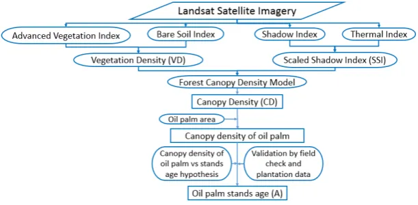
58
(OBIA) including by using various remote sensing data such as Landsat Thematic Mapper and
59
Worldview-2. Phenology characteristics unique to a particular species (e.g., rubber, oil palm) and
60
allow to differentiate from similar cover types such as natural forest, can be used as one approach to
61
map plantations using optical data [8].
62
McMorrow [9],[10] adopted Landsat Thematic Mapper and linear regression method to estimate
63
the age of oil palm plantations and found a better result at 1 -10 years old oil palm as compared to
64
other age groups [7]. Single age classes also cannot be accurately estimated at the pixel level in this
65
method. The use of generalized age classes (<5, 6-10, 11-15, >15 years) and post prediction averaging
66
to stand age classes made the accuracy was improved, but errors remain unacceptably high,
67
especially for old classes [10]. Srestasathiern and Rakwatin [11] proposed the use of vegetation index
68
that much powerful in distinguish oil palm and non-oil palm objects.
69
Ibrahim et.al [5] also employed Landsat TM to estimate oil palm age and developed a regression
70
model to distinguish age class using different variable such as vegetation indices and the leaf area
71
index. The results indicated a high correlation of using Landsat TM and the relationship between
72
Landsat TM bands and the age classes of the oil palm plantation. In addition, other factors such as
73
canopy, chlorophyll, and ground reflectance can be used to distinguish oil palm stands age class. [7].
74
Different from two previous researchers, Chemura [12] adopted high resolution satellite
75
imagery (Worldview-2) to investigate oil palm age. Object based image analysis (OBIA) method was
76
conducted to identify the crown area resulting an empirical function. Estimating oil palm age from
77
OBIA delineated crown area was showed that estimating oil palm age from this approach for the age
78
of younger oil palm (less than 8 years) will overestimated and underestimated older stands.
79
Several studies were conducted using remote sensing technique especially Forest Canopy
80
Density (FCD) model but most of them used for forest management and monitoring. Rikimaru, et.al
81
[13] used this model to map tropical forest cover density. In 2006, [14] conducted research to estimate
82
forest canopy density in a forest corridor linking the Himalayan middle mountains to the Royal
83
Chitwan National Park in Chitwan district Nepal, and tried to compare FCD model with three other
84
methods that are artificial neural network, multiple linear regression, and maximum likelihood
85
classification. Akike and Samantha [15] studied Forest Canopy Density (FCD) model to estimate
86
forest canopy density of the proposed deforestation site in Wafi-Golpu Project site, Papua New
87
Guinea. Himayah, et.al [16] also conducted forest reclamation priority of natural disaster areas at
88
Kelud Mountain, East Java using FCD Model.
89
The focus of this research is to estimate and distinguish oil palm stands age based on crown/
90
canopy density obtained from FCD model. Many factors can be used to explain the spectral response
91
of vegetation including interaction of radiation with canopy. Corley (1973) [5] explained that light
92
intensity below the canopy is important caused by oil palm canopy closure starts at 4 years-old stand.
93
By 20 years-old, the change of leaflets horizontal angle becomes less and more vertical. This condition
94
makes the canopy gap fraction is greater and the ground cover will have more contribution to light
95
intensity below the canopy. Multi-temporal satellite image analysis of oil palm plantation area also
has been performed in this research. This step is very useful for monitoring and detailing information
97
of oil palm stands age, and to investigate their correlation with canopy density.
98
2.Materials and Methods
99
2.1. Study Area
100
Study area of this research is located at PT. Perkebunan Nasional (PTPN) VIII as national
101
plantation company of Indonesia. PTPN VIII is one of national plantation companies of Indonesia
102
that was established under Government Regulation no. 13 of 1996. Cikasungka farm is one of PTPN
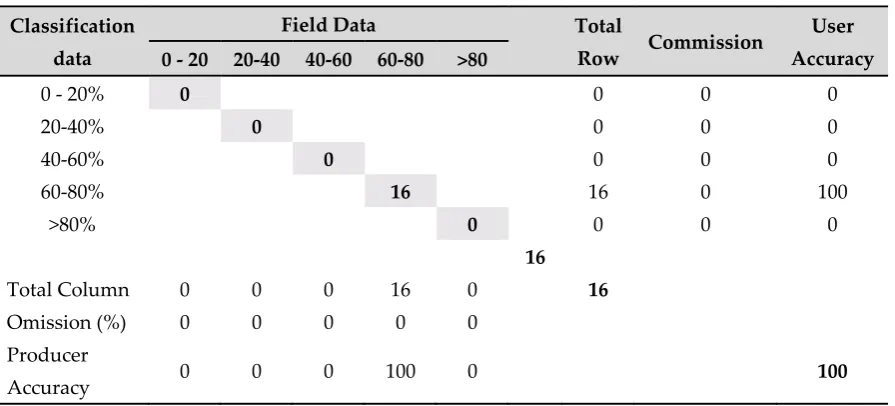
103
VIII farms located in Bogor District with total area around 3,500 ha. This farm has six division that
104
are Cimulang, Cindali, Cikasungka, Toge, Bolang, and Cigelung. In this research, only three division
105
that are Cimulang, Cindali, and part of Cikasungka with large area around 1,700 ha was chosen.
106
2.2. Datasets
107
In this research, we used Landsat satellite image time series path/ row 122/ 065 from 2003 until
108
2018 except 2011 caused by massive cloud coverage on the image data on the research area. The
109
satellite images data consist of Landsat 7 ETM that was acquired on May 2nd, 2003; Landsat 5 that was
110
acquired on April 29th, 2005; July 24th, 2007; and July 29th, 2009; also Landsat 8 OLI that was acquired
111
on July 8th, 2013; August 17th, 2016; June 17th, 2017; and April 1st, 2018.
112
2.3. Forest Canopy density (FCD) Model
113
The age of oil palm stands was predicted using remote sensing technique based on canopy
114
density. Forest canopy density (FCD) model was utilized as essential method to estimate stand age.
115
This model involved bio-spectral phenomenon modelling and analysis utilizing data derived from
116
four indices as follows Advanced Vegetation Index (AVI), Bare Soil Index (BSI), Shadow Index (SI),
117
and Thermal Index (TI) [17]. The result of four indices integration in this modelling is percentage of
118
canopy density in each pixel. Zero percent is no vegetation and 100 percent is very high density.
119
120
Figure 1. Forest canopy density model
121
Advanced Vegetation Index (AVI) was used to measure green vegetation. In remote sensing field,
122
healthy vegetation is characterized by high absorption and low reflectance in visible region. On the
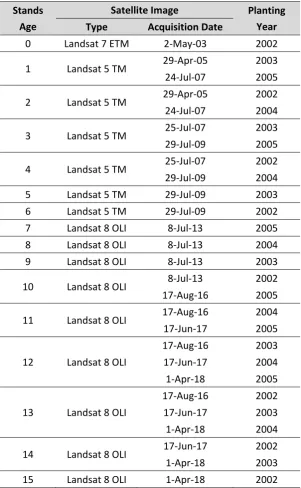
123
other hand, they will have low absorption and high reflectance in near infrared wavelength. AVI has
124
been calculated using Equation 1 for Landsat 5 and 7ETM or Equation 2 for Landsat 8 OLI.
125
𝐴𝑉𝐼 = (𝐵4 + 1) ∗ (256 − 𝐵3) ∗ (𝐵4 − 𝐵3) / (1)
𝐴𝑉𝐼 = (𝐵5 + 1) ∗ (65536 − 𝐵4) ∗ (𝐵5 − 𝐵4) / (2)
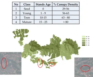
Similar to AVI, Bare Soil Index (BI) is normalized indices that used to separate vegetation and
126
their background. This index have opposite result with AVI because this is used to detect soil, it
means near infrared wavelength have low reflectance due to absorption by soil moisture. BI has been
128
calculated using Equation 3 for Landsat 5 and 7ETM or Equation 4 for Landsat 8 OLI.
129
(𝐵5 + 𝐵3)− (𝐵4 + 𝐵1)
(𝐵5 + 𝐵3)+ (𝐵4 + 𝐵1)𝑋100 + 100
(3)
(𝐵6 + 𝐵4)− (𝐵5 + 𝐵2)
(𝐵6 + 𝐵4)+ (𝐵5 + 𝐵2)𝑋100 + 100
(4)
The value of BI will have range of value from zero to 200 for each pixel which is highest
130
possibility of green leaves or canopy density if close to zero and non-vegetation surface or bare soil
131
if the value close to 200.
132
Shadow characteristics are defined by shadow index (SI) as spectral information because crown
133
arrangement of oil palm trees will have shadow pattern which affects spectral responses. The young
134
age will have low value of SI compare to the old oil palm trees. The shadow index is derived from
135
the low radiance of visible bands of Landsat 8 OLI image [7]. SI has been calculated using Equation
136
5 for Landsat 5 and 7ETM or Equation 6 for Landsat 8 OLI.
137
𝑆𝐼 = (256 − 𝐵1) ∗ (256 − 𝐵2) ∗ (256 − 𝐵3) / (5)
𝑆𝐼 = (65536 − 𝐵2) ∗ (65536 − 𝐵3) ∗ (65536 − 𝐵4) / (6)
Thermal Index (TI) was used to check if the black or shadow is real shadow not black soil. Land
138
surface that is close to shadow will have low temperature because leaf surface blocks and absorbs
139
energy from the sun. The source for this index comes from thermal band of Landsat 5 or 7 (band 6)
140
and Landsat 8 OLI data (band 10 and band 11). TI has been calculated using Equation 7 and 8.
141
𝐿𝐼= 𝑀𝐼∗ 𝑄𝑐𝑎𝑙+ 𝐴𝐼 (7)
where:
142
LI = Top of Atmosphere (TOA) radiance in (Watts/m2*srad*um)
143
MI =Band specific multiplicative rescaling factor from the metadata
144
(RADIANCE_MULTI_BAND_x, where x is the band number)
145
Qcal = Quantized and calibrated standard product pixel values (DN)
146
AI = Band specific additive rescaling factor from the metadata (RADIANCE_ADD_BAND_x, where
147
x is the band number)
148
𝑇 = 𝐾 /ln (𝐾
𝐿 + 1) (8)
where:
149
T = at-satellite brightness temperature (0K)
150
K2 = band specific thermal conversion constant from metadata (K2_CONSTANT_BAND_x; where
151
x is band number)
152
K2 = band specific thermal conversion constant from metadata (K1_CONSTANT_BAND_x; where
153
x is band number)
154
LI = product of the radiance formula
155
156
Forest Canopy Density (FCD) value was shown as percentage of canopy density. Integration of
157
four indices was used in the model to calculate canopy density. AVI and BSI was integrated to
158
produce vegetation density (VD). The processing method employed principal component analysis.
159
This result showed that AVI and BSI have high negative correlation. Higher AVI value have low
160
value in BSI because canopy density or vegetation cover is high and no bare soil or open surface at
161
there. After that, VD will be set in the percentage scaling from zero to a hundred percent point.
162
Another calculation is scaled shadow index (SSI) derived from linear transformation of SI. In
163
areas where the SSI value is zero (low) corresponds to oil palm plantation that have lowest shadow
164
value or minimum canopy density, opposites with areas where the SSI value is 100, which means has
165
high canopy density. VD and SSI were integrated to achieve FCD value using Equation 9. FCD was
used to estimate oil palm stands age with the assumption that older stands will have higher
167
percentage of canopy density.
168
𝐹𝐶𝐷 = (𝑉𝐷 ∗ 𝑆𝑆𝐼 + 1) / − 1 (9)
In this research, we have assumption if some variable was equal for all area such as soil type,
169
planting pattern, type of fertilizer, and another plantation management. It means only oil palm stands
170
age have significantly contribute to canopy density differentiation. Oil palm plantation management
171
have big correlation with canopy density is pruning tree branches. Many plantations have this policy
172
to keep the amount of sunlight in that plantation and it will make the dense of oil palm trees canopy
173
will different compare with natural oil palm trees.
174
Another assumption used in this research was non linier assumption [18][19] caused by the
175
characteristic of oil palm stands after 20 years old is different, the diameter of the canopy or stem
176
leaves increases is equal with growing phases, but the direction is different which stem leaves will
177
grow with smaller angle and tend to lead downwards [20].
178
179
Figure 2. Correlation of canopy density with the age of oil palm trees
180
Multi-temporal satellite image analysis of oil palm plantation area also has been conducted in
181
this research. This step is very useful for monitoring and detailing information of oil palm trees age
182
and to know their correlation with canopy density.
183
3.Results
184
3.1. Single date image analysis
185
This research was conducted from April 2017 until May 2018 and divided into two research
186
areas. Cimulang and Candali area was used as first area for field check. Based on image satellite
187
analysis from Landsat 8 OLI acquisition date on August 17th 2016, FCD model showed value range
188
from 49.4 – 74.6 % in this area. To evaluate the accuracy of FCD model, we conducted field check and
189
divided into 5 class that are 0-20%, 20-40%, 40-60%, 60-80%, and more than 80% to make it easier to
190
located sample point.
191
192
Figure 3. Canopy density of oil palm trees based on Landsat 8 OLI 2016 analysis
Field surveys in Cimulang and Candali area was conducted on October 2017 with 21 sample
194
points that was spread into two class that are 40-60% and 60-80%. In every sample point, we used
195
drone to take pictures from the air with coverage area of area 30m x 30m, this was chosen to make
196
sample area has similar size to Landsat 8 OLI pixel size. Based on the field check result, almost all
197
Candali and Cimulang area was covered by class 60-80% of canopy density and only one area in the
198
class more than 80% of canopy density. Two sample points with 40-60% of canopy density caused by
199
the influence from cloud shadow and built up area. The result of accuracy test based on field check
200
data in this area is accuracy 85.7% and shown in table 1.
201
202
Table 1. Accuracy test FCD model in Candali and Cimulang area
203
Classification
data
Field Data Total
Row Commission
User
Accuracy 0 - 20 20-40 40-60 60-80 >80
0 - 20% 0 0 0 0
20-40% 0 0 0 0
40-60% 0 2 1 3 100 0
60-80% 18 18 0 100
>80% 0 0 0 0
18
Total Column 0 0 0 20 1 21
Omission (%) 0 0 0 10 100
Producer
Accuracy 0 0 0 90 0 85.71
204
Cikasungka area was used as second area for field check. Based on image satellite analysis from
205
Landsat 8 OLI with acquisition date on June 17th, 2017, FCD model shows in this area have value from
206
57.7 – 79.5 %, but only one pixel show value less than 60% of canopy dense.
207
208
Figure 4. Canopy density of oil palm trees based on Landsat 8 OLI 2016 analysis
209
Field surveys in Cikasungka area was conducted on March 2018 with 16 sample point that was
210
only one class that is 60-80%. In every sample point, we used drone to took picture from the air with
211
large area 30m x 30m, this was choose to made sample area have same size with Landsat 8 OLI pixel.
Based on the result of field check, almost all of Cikasungka area covered by class 60-80% of canopy
213
dense. One pixel in image analysis that was shown 40-60% of canopy dense caused by the influence
214
from built up area.. The result of accuracy test based on field check data in this area had accuracy
215
100% and it was shown in table 2.
216
217
Table 2. Accuracy test FCD model in Cikasungka area
218
Classification
data
Field Data Total
Row Commission
User
Accuracy 0 - 20 20-40 40-60 60-80 >80
0 - 20% 0 0 0 0
20-40% 0 0 0 0
40-60% 0 0 0 0
60-80% 16 16 0 100
>80% 0 0 0 0
16
Total Column 0 0 0 16 0 16
Omission (%) 0 0 0 0 0
Producer
Accuracy 0 0 0 100 0 100
219
In the field check, we also tried to get secondary data such as planting years map. Based on the
220
field data and secondary data, all of research area have planting years from 2002 until 2005 with
221
distribution area was shown in Figure 5.
222
223
Figure 5. Planting years in research area
224
Based on planting year map and image satellite analysis, combining with non-linear assumption,
225
we tried to classify oil palm trees age and their correlation with canopy density and the results was
226
shown in table 3.
227
228
Table 3. Correlation stands age with canopy density
229
No Class Stands Age % Canopy Density
1 Seed 0 - 4 0 - 11
2 Young 4 - 9 11 - 41
3 Teen 9-15 41 - 80
4 Mature 15 - 25 > 80
3.2. Multi temporal image analysis
231
Multi-temporal satellite image analysis of oil palm plantation area also has been conducted as
232
one step to evaluate and detailing information of oil palm trees age and to know their correlation
233
with canopy density compare with single date image analysis.
234
The secondary data shown that planting years in research area started from 2002 until 2005 and
235
all of area was planted during October until December or in wet season. Based on this information,
236
we tried to analyze time series data which are acquisitioned during May 2003 until April 2018 which
237
are consist of Landsat 7 ETM that was acquired on May 2nd, 2003; Landsat 5 that was acquired on
238
April 29th, 2005; July 24th, 2007; and July 29th, 2009; also Landsat 8 OLI that was acquired on July 8th,
239
2013; August 17th, 2016; June 17th, 2017; and April 1st, 2018. Combination of time-series image analysis
240
and planting years was shown in table 4.
241
242
Table 4. Combination of time-series data and planting years
243
Stands Age
Satellite Image Planting
Year
Type Acquisition Date
0 Landsat 7 ETM 2-May-03 2002
1 Landsat 5 TM 29-Apr-05 2003
24-Jul-07 2005
2 Landsat 5 TM 29-Apr-05 2002
24-Jul-07 2004
3 Landsat 5 TM 25-Jul-07 2003
29-Jul-09 2005
4 Landsat 5 TM 25-Jul-07 2002
29-Jul-09 2004
5 Landsat 5 TM 29-Jul-09 2003
6 Landsat 5 TM 29-Jul-09 2002
7 Landsat 8 OLI 8-Jul-13 2005
8 Landsat 8 OLI 8-Jul-13 2004
9 Landsat 8 OLI 8-Jul-13 2003
10 Landsat 8 OLI 8-Jul-13 2002
17-Aug-16 2005
11 Landsat 8 OLI 17-Aug-16 2004
17-Jun-17 2005
12 Landsat 8 OLI
17-Aug-16 2003
17-Jun-17 2004
1-Apr-18 2005
13 Landsat 8 OLI
17-Aug-16 2002
17-Jun-17 2003
1-Apr-18 2004
14 Landsat 8 OLI 17-Jun-17 2002
1-Apr-18 2003
15 Landsat 8 OLI 1-Apr-18 2002
Based on planting year map and multi-temporal image satellite analysis, combining with
non-245
linear assumption, we tried to classify oil palm trees age and their correlation with canopy density
246
and the results was shown in table 5.
247
248
Table 5. Correlation stands age with canopy density
249
No Class Stands Age % Canopy Density
1 Seed 0 29-56
2 Young 1 - 9 56-63
3 Teen 10-15 63 - 80
4 Mature 15 - 25 > 80
250
251
Figure 6. Canopy density of oil palm trees 10-15 years old
252
This figure shows that oil palm trees from 10 until 15 years old will have canopy density around
253
63 – 80%. The other class in this figure (49-63%) was shown as settlement. This condition also seen in
254
the young class that was from one until nine years old. The value from 44-56% as known as
255
settlement.
256
257
Figure 7. Canopy density of oil palm trees 1-9 years old
258
4.Discussion
259
All of research area, Candali, Cimulang, and Cikasungka, based on single-date image satellite
260
analysis and field check survey shows that oil palm trees in that area have age around 10 – 14 years
261
old. This also as evidence for their correlation with canopy density. In this class, all of oil palm trees
262
age have 60-80% of canopy dense and area with value less than 60% as known as settlement.
Based on classification from Plantation Education Agency of Indonesia, we can divide into four
264
class even from this agency they divided into five class. The last class for old age from 20-25 years
265
old was union into mature class caused by non-linear assumption that was characteristic from oil
266
palm trees after 20 years old is different, the length of canopy or steam leaves increases is equal with
267
growing phases, but the direction is different which steam leaves will grow with smaller angle and
268
tend to lead downwards[18][19].
269
To evaluate and specify the class from single data analysis, we employed multi temporal image
270
analysis. The result shows if the number of class for oil palm trees age are still divided into four class
271
that were seed only for zero old, young for one until nine years old, teen for 10 until 15 years old, and
272
mature for more than 15 years old.
273
The canopy density value from one until nine years old, even starts from 34 until 65% but mostly
274
have 56-63 % of canopy dense. The value below 56 caused by settlement or near with settlement, and
275
for value more than 63 caused by their location near with other plantation such as rubber. It was very
276
difficult to separate young class due to the absence of oil palm trees with age between one until nine
277
years old in the field.
278
Limitation from this research area the absence of oil palm trees with age between one until nine
279
years old also more than 15 years old in the field. This made we cannot evaluate the density value for
280
that stands age in the field.
281
Future research will be better to conduct in oil palm plantation area that they have large range
282
in diversity of stands age. In line with that, this research also can be evaluate for other oil palm
283
plantation with different condition such as soil type, precipitation, contour, and planting
284
management
285
5.Conclusions
286
This research was conducted to applied FCD model as one tools to estimate the age of oil palm
287
trees. The result for single date data and multi temporal image analysis was shows if there is no
288
obvious difference in the number of classes, which are only have four class that are seed, young, teen,
289
and mature.
290
Generally, FCD model can be used as a tool to estimate the age of oil palm trees even though it
291
was difficult to separate the class of one until nine years old and more than 15 until 25 years old.
292
From this research we can see if in the oil palm plantation we cannot found canopy density less than
293
29% even in the zero years old. This could be indicates that plantation was not optimize in land
294
clearance or this phenomenon happen caused by the type of seed of oil palm trees that was like a
295
young trees.
296
6.Patents
297
Author Contributions: Fitrianto and Tokimatsu conceptualized and designed the project; Fitrianto and Yuwono
298
executed image processing and analysis, Darmawan performed statistical analysis, Fitrianto, Yuwono, and
299
Darmawan wrote the paper, Tokimatsu supervised research and edited the manuscript.
300
Funding: This research received no external funding
301
Acknowledgments: Ministry of Research, Technology and Higher Education of Indonesia for the scholarship.
302
Thanks to National Plantation Company of Indonesia (PTPN VIII) for supporting data and their permission to
303
conducted this research in their area.
304
Conflicts of Interest: The authors declare no conflict of interest. The founding sponsors had no role in the design
305
of the study; in the collection, analyses, or interpretation of data; in the writing of the manuscript, and in the
306
decision to publish the results.
307
308
References
309
[1] K. T. Tan, K. T. Lee, A. R. Mohamed, and S. Bhatia, “Palm oil: Addressing issues and towards sustainable
310
[2] A. Casson, “Oil Palm, Soybeans, and Critical Habitat Loss,” A Rev. Prep. WWF For. Convers. Initiat., no.
312
August, 2003.
313
[3] S. Sumathi, S. P. Chai, and A. R. Ã. et. a. Mohamed, “Utilization of oil palm as a source of renewable
314
energy in Malaysia,” Renew. Sustain. Energy Rev. 12, vol. 12, pp. 2404–2421, 2008.
315
[4] C. Petrenko, J. Paltseva, and S. Searle, “ECOLOGICAL IMPACTS OF PALM OIL EXPANSION IN
316
INDONESIA,” Int. Counc. Clean Transp., no. July, 2016.
317
[5] M. Ibrahim, S., Hassan, Z. and Khalid, “Application of optical remote sensing technology for oil palm
318
management,” 21st Asian Conf. Remote Sens. Conf., 2000.
319
[6] S. Vadivelu, A. Ahmad, and Y. H. Choo, “REMOTE SENSING TECHNIQUES FOR OIL PALM AGE
320
CLASSIFICATION USING LANDSAT-5 TM SATELLITE,” vol. 26, no. 4, pp. 1547–1551, 2014.
321
[7] S. A. Mansor, M. Latifur, and R. Sarker, “REMOTE SENSING TECHNIQUE FOR ESTIMATING THE
322
AGE OF OIL PALM USING HIGH RESOLUTION IMAGE,” Proc. 36th Asian Conf. Remote Sens. 2015, vol.
323
36, 2015.
324
[8] N. Torbick, L. Ledoux, W. Salas, and M. Zhao, “Regional mapping of plantation extent using multisensor
325
imagery,” Remote Sens., vol. 8,236, 2016.
326
[9] J. M. McMORROW, “Relation of oil palm spectral response to stand age,” Int. J. Remote Sens., 1995.
327
[10] J. McMorrow, “Linear regression modelling for the estimation of oil palm age from Landsat TM,” Int. J.
328
Remote Sens., 2001.
329
[11] P. Srestasathiern and P. Rakwatin, “Oil palm tree detection with high resolution multi-spectral satellite
330
imagery,” Remote Sens., vol. 6, pp. 9749–9774, 2014.
331
[12] A. Chemura and I. C. Van Duren, “Determination of the age of oil palm from crown projection area
332
detected from WorldView-2 multispectral remote ...,” ISPRS J. Photogramm. Remote Sens., no. August,
333
2014.
334
[13] A. Rikimaru, P. S. Roy, and S. Miyatake, “Tropical forest cover density mapping,” Trop. Ecol., 2002.
335
[14] C. Joshi, J. De Leeuw, A. K. Skidmore, I. C. va. Duren, and H. van Oosten, “Remotely sensed estimation
336
of forest canopy density: A comparison of the performance of four methods,” Int. J. Appl. Earth Obs.
337
Geoinf., vol. 8, no. 2, pp. 84–95, 2006.
338
[15] S. Akike and S. Samanta, “Land Use/Land Cover and Forest Canopy Density Monitoring of Wafi-Golpu
339
Project Area, Papua New Guinea,” J. Geosci. Environ. Prot., vol. 4, no. 4, pp. 1–14, 2013.
340
[16] Himayah et al, “The Utilization of Landsat 8 Multitemporal Imagery and Forest Canopy Density ( FCD
341
) Model for Forest Reclamation Priority of Natural Disaster Areas at Kelud Mountain , East Java,” IOP
342
Conf. Ser. Earth Environ. Sci. 47, vol. 47, 2016.
343
[17] A. Rikimaru, P. S. Roy, and S. Miyatake, “Tropical forest cover density mapping,” Int. Soc. Trop. Ecol.
344
Trop., vol. 43, no. 1, pp. 39–47, 2002.
345
[18] A. C. Fitrianto, K. Tokimatsu, and M. Sufwandika, “Estimation the Amount of Oil Palm Trees Production
346
Using Remote Sensing Technique,” IOP Conf. Ser. Earth Environ. Sci., vol. 98, no. 1, 2017.
347
[19] A. C. Fitrianto, A. Darmawan, K. Tokimatsu, and M. Sufwandika, “Estimating the age of oil palm trees
348
using remote sensing technique,” IOP Conf. Ser. Earth Environ. Sci. 148, vol. 148, 2018.
349
[20] A. Yudi, “PEMANFAATAN CITRA LANDSAT 7 UNTUK ESTIMASI UMUR TANAMAN KELAPA
350