13. S
ITE
1220
1Shipboard Scientific Party
2BACKGROUND AND OBJECTIVES
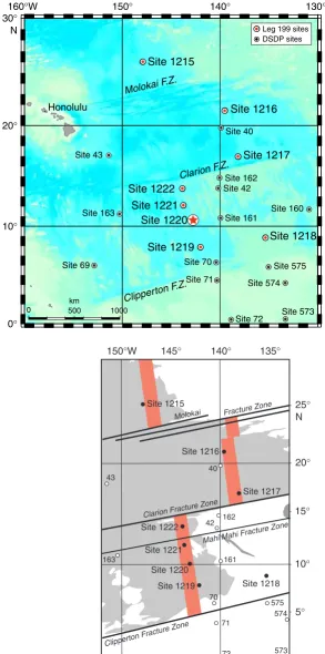
Site 1220 (10°10.600′N, 142°45.503′W; 5218 meters below sea level (mbsl); Fig. F1) forms a southerly component of the 56-Ma transect drilled during Leg 199. It is situated about midway between the Clipper-ton and Clarion Fracture Zones in typical abyssal hill topography. On the basis of regional magnetic anomalies, we anticipated basement age at Site 1220 to be equivalent to Chron C25n (~56 Ma; Cande et al., 1989), slightly older than at Site 1219. At the outset of drilling at Site 1220, our estimate for total sediment depth was ~225 meters below sea-floor (mbsf) (Fig. F2).
Based upon a fixed hotspot model (Gripp and Gordon, 1990, for 0- to 5-Ma Pacific hotspot rotation pole; Engebretson et al., 1985, for older poles), Site 1220 should have been located ~3° south of the equator at 56 Ma and in an equatorial position at 40 Ma. Thus, Site 1220 should have been situated underneath the South Equatorial Current in the early Eocene. A nearby piston core (EW9709-13PC) taken during the site survey cruise recovered >16 m of red clay, with the base of the core dated as middle–early Miocene on the basis of radiolarian biostratigra-phy (Lyle, 2000).
Site 1220 will be used to study equatorial ocean circulation from the late Paleocene through the late Eocene during the early Cenozoic ther-mal maximum. Sediment records from this site will help to define the calcite compensation depth (CCD) and lysocline during the Paleocene– Eocene and Eocene–Oligocene transitions. In this and other respects, Site 1220 will act as an interesting analog to Site 1218. Both sites are thought to have been located on the equator at ~40 Ma, but the older crustal age anticipated at Site 1220 dictates a greater paleowater depth than for contemporaneous sediments accumulating at Site 1218.
160°W 150° 140° 130°
0° 10° 20° 30° N
0 500 1000
Site 1215 Site 1216 Site 1217 Site 1218 Site 1219 Site 1220 Site 1221 Site 1222 Site 40 Site 42 Site 43
Site 69 Site 70 Site 71 Site 72 Site 160 Site 161 Site 162 Site 163 Site 573 Site 574 Site 575 Honolulu
Molokai F.Z.
Clipperton F .Z. Clarion F.Z.
Site 1216 Site 1217 Site 1218 Site 1222 Site 1221 Site 1220 Site 1215 Molokai Fractu re Zone
Clarion Fracture Zone
Mahi M ahi Fracture Zone
Site 1219 Clipp erton Fractu re Zone 574 573 575 161 162 163 40 42 43 70 71 72 0° 10° 20° 5° 15° 25° N 150°W 145° 140° 135°
km
Leg 199 sites DSDP sites F1. Site location map, p. 32.
3 km W E T w o-w a y tr a v eltime (ms) Hour Minute 6500 6600 6700 6800 6900 7000 7100 7200 7300 PAT9-Line 2 Bandpass Site 1220 PAT-9D P2 P3 P4 P5 Basement
F2. Seismic reflection profile, p. 33.
1Examples of how to reference the
whole or part of this volume.
2Shipboard Scientific Party
addresses.
SUMMARY
Site 1220 (10°10.601′N, 142°45.491′W) forms a southerly component of the 56-Ma transect to be drilled during Leg 199. It is situated halfway between the Clipperton and Clarion Fracture Zones at a water depth of 5218 mbsl in typical abyssal hill topography. On the basis of regional magnetic anomalies, we anticipated basement age at Site 1220 to be equivalent to Anomaly An25n (~56 Ma) (Cande et al., 1989), slightly older than at Site 1219.
Based upon a fixed hotspot model (Gripp and Gordon, 1990, for the 0- to 5-Ma Pacific hotspot rotation pole; Engebretson et al., 1985, for older poles) Site 1220 should have been located ~3°S of the equator at 56 Ma and in an equatorial position at 40 Ma. Thus, Site 1220 should have been situated beneath the South Equatorial Current in the early Eocene. Site 1220 data will be used as a deeper analog to Site 1218. Both sites are thought to have been located in an equatorial position at ~40 Ma, but Site 1220 was ~400 m deeper at this time.
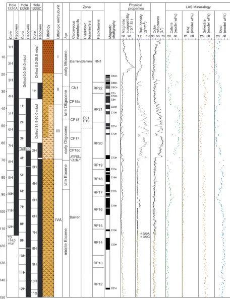
Three holes were drilled at Site 1220. Hole 1220A was terminated when an advanced piston corer (APC) core jammed in the bottom-hole assembly (BHA) at ~100 mbsf, but basement was reached in Holes 1220B and 1220C at ~200 mbsf. Cores from Site 1220 overlap and form a continuous sedimentary sequence down to ~144 meters composite depth (mcd) (base of Core 199-1220B-10H). The sedimentary sequence recovered at the site is divided into five major sedimentary units. The uppermost unit (~0–19 mbsf) consists of very dark grayish brown clay with zeolites and is underlain by a lower Miocene–Oligocene Unit II (~19–40 mbsf) of radiolarian and nannofossil oozes with varying clay content. The underlying Oligocene radiolarian and nannofossil oozes of Unit III (~40–70 mbsf) are notable by the presence of a significant (~15%–45%) diatom component toward the base. Unit IV (~70–185 mbsf) consists of upper Eocene radiolarian oozes with clay and middle– lower Eocene chert with clayey radiolarian ooze. These sediments are underlain by a lower Eocene–upper Paleocene unit (~185–200 mbsf) of partially dolomitized nannofossil ooze, radiolarian nannofossil ooze, radiolarian ooze, calcareous chalk, and black clay atop an aphanitic to fine-grained phaneritic basalt.
Paleomagnetic data from Site 1220 gave excellent results and a reli-able record of geomagnetic reversals from the early–middle Eocene to the early Miocene. The composite depth record from Holes 1220A, 1220B, and 1220C shows a remarkable match of the cores between the different holes. In fact, the virtual geomagnetic pole (VGP) latitude changes were used as a basis to help fit the cores to the mcd depth scale. Correlation of the magnetic stratigraphy at Site 1220 to the geomag-netic polarity timescale (GPTS) shows a record that spans from the top of Chron C21n to Subchron C6An.1n (~20.5–46.3 Ma).
calcar-eous nannofossils provide a detailed zonation of a condensed sequence of lower Eocene nannofossil oozes and chert in the basal 10 m of Site 1220. The extinction of Paleocene benthic foraminifers, the appearance of the nannofossil genus Rhomboaster, the extinction of the nannofossil genus Fasciculithus, and the presence of “excursion fauna” of plank-tonic foraminifers provide a detailed biostratigraphy of the Paleocene/ Eocene (P/E) boundary in Unit V. The nannofossil events occur 0.8–1.4 m above the extinction of Paleocene benthic foraminifers. The excur-sion fauna of planktonic foraminifers is present in sediments below the level of the benthic foraminifer extinction in sediments immediately overlying basalt. Thus, none of these events are precisely synchronous with the benthic foraminifer extinction, the marker we used for the P/E boundary, at this site.
Interstitial pore water profiles from Site 1220 are very similar to the profiles of all other Leg 199 sites except Site 1219 and primarily reflect minor organic matter degradation, the dissolution of biogenic silica, and minor alteration of underlying basalt. The bulk geochemistry of the sediments from Site 1220 reflects the shifts in lithology between sediments dominated by silica and carbonate.
Physical properties of the sediments also primarily reflect lithology. The carbonate sediments are higher in density, lower in porosity, and lower in magnetic susceptibility (MS) than the clay or radiolarian ooze lithologies. The radiolarian-rich sediments of Units II and IV are marked by high porosities, which average 88% and 85%, respectively. The radiolarian oozes maintain their porosity despite burial. The Eocene radiolarian oozes have the highest P-wave velocities of the un-consolidated sediment lithologies.
Highlights
Magnetic Reversal Stratigraphy
The clean record of magnetic reversal history from Site 1220 (for the entire APC-cored sediment section; 0–150 mbsf) spans the lower Mio-cene to the lower–middle EoMio-cene (Subchron C6An.1n to the top of Chron C21; 20.05–46.3 Ma). This record is remarkable for a tropical site and will provide invaluable time control for calibration of radiolarian biostratigraphy. Because there are cyclic variations in radiolarian con-tent of the Site 1220 Eocene section, presumably driven by orbital forc-ing of insolation, this record could be highly important for orbital tun-ing of the GPTS from the middle Eocene through the early Miocene.
Eocene/Oligocene Boundary
A combination of magnetostratigraphy and nannofossil biostratigra-phy indicates that we recovered a further Eocene/Oligocene (E/O) boundary at Site 1220 (~70 mbsf). Shore-based work on this section, to-gether with those recovered at Sites 1217, 1218, and 1219, will allow us to improve existing constraints on the links between global cooling, Antarctic ice sheet growth, and a deepening CCD across this important paleoceanographic boundary.
P/E Boundary
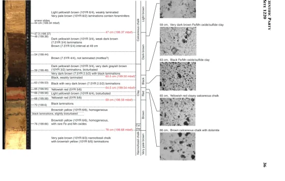
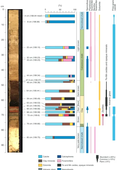
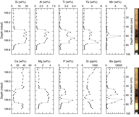
Based on biostratigraphic data, this sequence represents the P/E bound-ary. Layers of calcareous chalk and clay display a large range in compo-sition and color downcore. Alternating intervals of white and very pale brown calcareous chalk are present between 198.9 and 199.4 mbsf and contain a minor amount (5%–10%) of poorly preserved nannofossils. White layers are present between 199.15 and 199.23 mbsf and contain 15%–30% planktonic foraminifers. The sediments below this interval consist of faintly banded dark yellowish brown calcareous chalk but are barren of microfossils. Dolomite (up to 10%) and clay (10%–35%) are also present in this lithology. Below 199.50 mbsf is a 4-cm-thick layer of very dark brown (7.5YR 2.5/3) calcareous chalk underlain by a black clay. Major components of both sediments are dolomite, iron manga-nese oxides, and clay. Volcanic glass is present as a minor component. Dolomite content decreases over the interval from 199.52 to 199.54 mbsf, and no calcareous or siliceous fossils were observed in corre-sponding smear slides. Directly beneath the black clay is a 4.5-cm-thick interval of yellowish red calcareous chalk. In this interval is a 1-cm-thick brownish yellow layer of calcareous chalk. Sediments in the yel-lowish red layers are weakly laminated and contain clay, dolomite, cal-cite, and a minor percentage of nannofossils. Iron manganese oxides and opaque minerals are minor components. The brownish yellow chalk layer contains clay, dolomite, iron manganese oxides, volcanic glass, and abundant small mottles. Nannofossils are rare in these layers. The base of the sedimentary section contains a 9-cm-thick interval of brownish yellow clayey calcareous chalk (199.59–199.68 mbsf) with thin black laminations. Dolomite comprises up to 10% of these sedi-ments. Zeolites and nannofossils are also present as minor components. Iron manganese oxides are rare. Laminations contain clay, iron manga-nese oxides, dolomite, zeolites, and small amounts of volcanic ash and are barren of calcareous fossils.
OPERATIONS
Transit to Site 1220 (PAT-9D)
The 149-nmi voyage to proposed Site PAT-9D was accomplished in 13.3 hr at an average speed of 11.2 kt. At 1800 hr on 28 November, 2001, the vessel slowed to 5 kt, and a short 3.5-kHz survey was made from east to west across the site. Upon conclusion of the 1-hr survey, the vessel came about and returned to site as the thrusters were lowered and the dynamic positioning system (DPS) was activated. The Global Positioning System receiver interface to the DPS was employed to situ-ate the vessel over the coordinsitu-ates of the new location by 1915 hr. A beacon was deployed at 2006 hr. The corrected precision depth recorder (PDR) depth was 5234.4 meters below rig floor (mbrf).
Hole 1220A
rou-tinely to 95.0 mbsf (Cores 1H through 10H) with excellent recovery (Table T1). Cores were oriented starting with Core 3H.
During the process of obtaining Core 11H, the overshot shear pin parted and the Tensor tool was recovered without the core barrel. The Tensor tool was set aside, and a second wireline trip with the sinker bars was made to retrieve the core barrel. Upon retrieval, the core barrel was momentarily stuck but quickly came free and was recovered. Core 12H was taken in the customary manner with a full bleed-off of pressure, in-dicating a full stroke. The sinker bars and Tensor tool were retrieved by the wireline but without the core barrel. The Tensor tool was laid down, and the wireline jars were deployed to recover the core barrel. The core barrel could not be released by alternately applying overpull and up-ward impacts with the wireline jars. The effort was given up after 45 min, the overshot shear pin was intentionally parted, and the wireline was recovered. The drill string was then retrieved, and the hole was ter-minated.
APC operations in Hole 1220A resulted in 114.0 m cored with 118.7 m recovered (average recovery 104.1%).
Hole 1220B
After the BHA was redeployed, the vessel was offset 20 m west of Hole 1220A in preparation for the spudding of Hole 1220B. The drill string was deployed to a depth of 5215.5 mbrf, and Hole 1220B was spudded at 2215 hr on 30 November. After the bit was drilled to 34.0 mbsf, APC operations were initiated and the hole was deepened to 152.0 mbsf. The interval from 62.5 to 64.5 mbsf was drilled to maintain an appropriate stratigraphic overlap with Hole 1220A. The cored inter-val was 116.0 m with 126.8 m recovered (109.3% recovery). All piston cores were oriented. The Adara temperature tool was deployed at 53.0 mbsf (Core 2H), 83.5 mbsf (5H), and 102.5 mbsf (7H). The developmen-tal methane tool was deployed and appeared to have successfully ob-tained data.
Hole 1220B was deepened from 152.0 to 202.0 mbsf with extended core barrel (XCB) coring (Table T1) and penetrated basaltic basement with the last core (Core 20X). XCB operations deepened the hole 50.0 m and recovered 17.8 m of sediment (35.6% recovery). The total recov-ery for the hole was 144.7 m, representing 87.1% of the cored interval.
Hole 1220B was terminated when the bit cleared the seafloor at 1530 hr on 2 December. The vessel was then offset 20 m west of Hole 1220B.
Hole 1220C
Hole 1220C was spudded at 1600 hr on 2 December. After the bit was drilled to 25.0 mbsf, one piston core was obtained spanning the Oli-gocene/Miocene (O/M) boundary (25.0–34.5 mbsf). The hole was then drilled from 34.5 to 60.0 mbsf, where continuous piston coring was ini-tiated, and the hole was advanced to 145.5 mbsf. The APC-cored inter-val was 95.0 m with 98.0 m recovered (103.2% recovery) (Table T1). All APC cores were oriented. Hole 1220C was deepened from 145.5 to 204.1 mbsf with XCB coring operations. Basaltic basement was reached with the last core (Core 17X). The XCB-cored interval was 58.6 m with 18.13 m recovered (30.9%). The total recovery for the hole was 153.6 m, representing 75.6% of the cored interval (Table T1).
Following the end of coring operations in Hole 1220C, the drill string was pulled to the deck, the beacon was retrieved, and the drilling
equipment, hydrophones, and thrusters were secured. The vessel de-parted location at 0930 hr on 4 December.
LITHOSTRATIGRAPHY
Drilling at Site 1220 recovered a 200.3-m section of pelagic sediments overlying seafloor basalt. The upper 25 m is lower Miocene clay and diolarian ooze, underlain by 45.6 m of Oligocene nannofossil and ra-diolarian ooze and 129 m of Eocene rara-diolarian ooze with alternations of nannofossil ooze, clay, and chert. A 25-cm-thick upper Paleocene chalk section was recovered above basement.
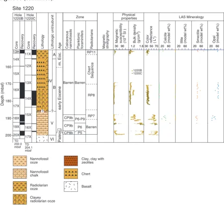
The sedimentary sequence at Site 1220 has been divided into six ma-jor lithologic units and subunits (Fig. F3). Lithologic descriptions for 0 to 114.0 mbsf are primarily based on sediments from Hole 1220A. Be-low 114.0 mbsf, descriptions are based on the sequence recovered in Holes 1220B and 1220C.
Unit I
Interval: 199-1220A-1H-1, 0 cm, through 3H-1, 11 cm Depth: 0.0–19.1 mbsf (Hole 1220A)
Age: early Miocene
Lithology: clay and clay with zeolites
Unit I consists of very dark grayish brown (10YR 4/2) clay with zeo-lites grading to a dark brown (10YR 3/3) clay. Zeozeo-lites are a significant component (10%–15%) in the upper 14.9 m (Sections 199-1220A-2H-1 through 2H-4, 93 cm). Mottles are common in the uppermost 9.5 m of Unit I and rare between 9.5 and 19.4 mbsf (Sections 199-1220A-1H-CC through 2H-CC). Iron oxides and manganese nodules are present in mi-nor to trace amounts below 18.2 mbsf (Section 199-1220A-2H-6, 130 cm).
Unit II
Intervals: 1220A-3H-1, 11 cm, through 4H-6, 110 cm; 199-1220B-1H-1, 0 cm, through 1H-4, 55 cm; and 199-1220C-1H-1, 0 cm, through 1H-CC, 26 cm
Depths: 19.1–37.2 mbsf (Hole 1220A); 34.0–39.0 mbsf (Hole 1220B); and 25.0–34.5 mbsf (Hole 1220C)
Age: early Miocene to Oligocene
Lithology: radiolarian ooze with clay, nannofossil radiolarian ooze with clay, and nannofossil ooze with clay and radiolarians
The dominant lithology in Unit II is very dark brown (7.5YR 2.5/3) to dark yellowish brown (10YR 3/4) radiolarian ooze. Thin alternations of yellowish brown (10YR 6/4) nannofossil radiolarian ooze are present be-tween 24 and 27 mbsf (interval 199-1220A-3H-4, 55 cm, through 3H-6, 85 cm). Contacts between the lithologies are gradational and mottled. Brownish yellow (10YR 6/6) mottles are common to abundant in both lithologies.
Core
Depth (mbsf)
RecoveryCoreRecoveryCoreRecovery
Hole 1220AHole 1220BHole 1220C 10 1H 2H 3H 1H
Drilled 0.0-34.0 mbsf
Drilled 0.0-25.0 mbsf
Drilled 34.5-60.0 mbsf
4H 1H 2H 3H 4H 2H 3H 4H 5H 6H 7H 8H 9H 10H 11X 5H 6H 7H 8H 9H 10H 11H Drilled 5H 6H 7H 8H 9H 10H 11H 12H 20 30 40 60 70 80 90 110 120 TD 114.0 mbsf 130 140 50 100 150 Site 1220 12H
Magneticsusceptibility(10
-6
SI )
Bulk density(g/cm 3)
Magneticstratigraphy
Color reflectance(L*) Calcite(model wt%) Illite(model wt%) Smectite(model wt%) Opal(model wt%) Lithology Lithologic unit/subunitAge
Physical properties LAS Mineralogy Zone
Planktonicforaminifers Calcareousnannofossils Radiolarians
1220A 1220C
1.21.630 50 702060206020602060 30 90 P21- P19 RP22 RP21 RN1 RP20 RP19 RP18 RP17 RP16 RP15 RP14 RP13 RP12 CP18 CP17 CP16c CP16 a+b CP19a CN1 Barren Barren Barren early Miocene late Oligocene early Oligocene late Eocene middle Eocene I II IV III A C21n C20n C19n C18n C17n C16n C15n C13n C12n C11n C10n C20n C8n C7n C6Cn C6An C6Bn C7An
Unit III
Intervals: 1220A-4H-6, 110 cm, through 8H-2, 115 cm; 199-1220B-1H-4, 55 cm, to 4H-6, 81 cm; and 199-1220C-2H-1 through 3H-2, 16 cm
Depths: 37.2–69.2 mbsf (Hole 1220A); 39.0–71.4 mbsf (Hole 1220B); and 60.0–71.2 mbsf (Hole 1220C)
Age: Oligocene
Lithology: nannofossil ooze, radiolarian ooze with clay and radio-larians, and nannofossil diatom ooze
Unit III consists of pale brown (10YR 8/3) to yellowish brown (10YR 5/4) nannofossil ooze. Between 37.2 and 56.9 mbsf (interval 199-1220A-4H-6, 123 cm, through 6H-7, 40 cm), the nannofossil ooze alternates with decimeter-scale intervals of dark brown (10YR 3/3) radiolarian ooze and light yellowish brown (10YR 6/4) nannofossil diatom ooze. The thickness of the nannofossil ooze layers increases downcore, and color grades to very pale brown (10YR 8/2). Contacts between lithologies are gradational and are obscured by bioturbation.
Clay content (based on smear slide descriptions) ranges from <5% in nannofossil ooze to 15%–20% in radiolarian ooze. Diatoms are absent in the upper portion of Unit III but increase from 15% to 45% down-core in the lowermost 6 m of the unit.
Unit IV
Intervals: 199-1220A- 8H-2, 115 cm, through 12H-CC; 199-1220B-4H-6, 81 cm, through 17X-CC; and 199-1220C-3H-2, 16 cm, through 14X-CC
Depths: 69.2–114.0 mbsf base of hole (Hole 1220A); 71.4–187.9 mbsf (Hole 1220B); and 71.2–183.5 mbsf (Hole 1220C)
Age: late to early Eocene
Lithology: radiolarian ooze with clay, clayey radiolarian ooze, clay with radiolarians, and chert
Unit IV is divided into two subunits, based on the presence or absence of chert. Subunit IVA consists of radiolarian ooze with varying clay con-tent, and Subunit IVB is composed of chert and clayey radiolarian ooze.
Subunit IVA
Intervals: 199-1220A-8H-2, 115 cm, through 12H-CC; 199-1220B-4H-6, 81 cm, through 13X-CC; and 199-1220C-3H-2, 16 cm, through 11X-CC
Depths: 69.2–114.0 mbsf base of hole (Hole 1220A); 71.4–159.2 mbsf (Hole 1220B); and 71.2–155.1 mbsf (Hole 1220C)
Age: late to middle Eocene
Lithology: radiolarian ooze with clay, clayey radiolarian ooze, and clay with radiolarians
An interval of clay with radiolarians is present near the base of Sub-unit IVA (Hole 1220B: 144.2–152.0 mbsf). The thickness of this clay is probably exaggerated in Hole 1220B by sediment flow-in associated with coring a 5-cm-thick claystone interval (intervals 199-1220B-13H-1, 75–80 cm, and 199-1220C-11X-2, 89–94 cm).
Subunit IVB
Intervals: 199-1220B-14X-1, 0 cm, through 17X-CC; and Section 199-1220C-12X, 0 cm, through 14X-CC
Depths: 159.2–187.9 mbsf (Hole 1220B) and 155.1–183.5 mbsf (Hole 1220C)
Age: middle to early Eocene
Lithology: chert and clayey radiolarian ooze
Subunit IVB consists of chert and clayey radiolarian ooze. The chert and surrounding sediment were poorly recovered. Chert occurs as black (N1) fragments broken by the drilling process. Clayey radiolarian ooze ranges from strong brown (7.5YR 4/6) to yellowish brown (10YR 5/6). Decimeter-scale alternations of clay and radiolarian ooze with iron ox-ides are present between 173.9 and 183.5 mbsf (Sections 199-1220B-16X-4, 25 cm, through 16X-CC and 199-1220C-14X-1, 0 cm, through 14X-CC). Yellowish brown (10YR 5/4) mottles are common throughout this subunit. A layer of volcanic ash is present near 171.5 mbsf (interval 199-1220B-16X-2, 88–92 cm).
Unit V
Intervals: 199-1220B-18X-1, 0 cm, through 20X-CC, 12 cm; and 199-1220C-16X-1, 0 cm, through 16X-CC
Depths: 187.9-200.0 mbsf (Hole 1220B) and 193.0–197.4 mbsf (Hole 1220C)
Age: early Eocene to late Paleocene
Lithology: nannofossil ooze, radiolarian nannofossil ooze, radiolar-ian ooze, calcareous chalk, and clay
Unit V primarily consists of light yellowish brown (10YR 6/4) to very pale brown (10YR 7/4) nannofossil ooze and radiolarian nannofossil ooze. Dark yellowish brown (10YR 4/6, 10YR 3/6) radiolarian ooze is present between 190.42 and 190.8 mbsf (interval 199-1220B-18X-3, 20– 58 cm). Very pale brown (10YR 7/2) mottles are common. Authigenic dolomite crystals constitute a significant proportion of the nannofossil ooze (10%–35%).
P/E Sediments
Between 198.9 and 199.7 mbsf (interval 199-1220B-20X-2, 4–85 cm), there is an interval of calcareous chalk and clay. Based on biostrati-graphic data (see “Biostratigraphy,” p. 10), this sequence represents the P/E boundary. The P/E boundary was only recovered in Hole 1220B. Layers of calcareous chalk and clay display a large range in composition and color downcore (Figs. F4, F5). Alternating intervals of white and very pale brown (10YR 8/3) calcareous chalk are present between 198.9 and 199.4 mbsf (interval 199-1220B-20X-2, 10–48 cm) and contain a minor amount (5%–10%) of poorly preserved nannofossils. White lay-ers are present between 199.15 and 199.23 mbsf (interval
199-1220B-black laminations, slightly bioturbated 44 cm (199.34 mbsf)
47.3 (199.37) 48 (199.38) 54 (199.44) smear slides 59 (199.49) 63 (199.53) 65 (199.55) 66 (199.56) 68 (199.58) 70 (199.6) 76 (199.66) Light bro wn Dar k bro wn Red Bro w n B lac k Very pale bro w n Calcareous chalk Cla y Cal. clay Nannof ossil chalk
48 cm, Dark brown calcareous chalk
59 cm, Very dark brown Fe/Mn oxide/sulfide clay
63 cm, Black Fe/Mn oxide/sulfide clay
65 cm, Yellowish red clayey calcareous chalk
66 cm, Brown calcareous chalk with dolomite 40 cm 45 50 55 60 65 70 75 80
Light yellowish brown (10YR 6/4), weakly laminated Very pale brown (10YR 8/2) laminations contain foraminifers
Dark yellowish brown (10YR 3/4), weak dark brown (7.5YR 3/4) laminations Brown (7.5YR 5/4) interval at 49 cm
Brown (7.5YR 4/4), not laminated (mottles?)
Dark yellowish brown (10YR 3/4), very dark grayish brown (10YR 3/2) laminations, bioturbated
Black, weakly laminated
Black with very dark brown (7.5YR 2.5/2) laminations Yellowish red (5YR 5/6) Light yellowish brown (10YR 6/4), bioturbated Yellowish red (5YR 5/6) Black laminations
Very pale brown (10YR 8/3) nannofossil chalk with brownish yellow (10YR 6/6) laminations Brownish yellow (10YR 6/6), homogeneous
Brownish yellow (10YR 6/6), homogeneous, with rare Fe and Mn oxides
47 cm (199.37 mbsf)
Very dark brown (7.5YR 2.5/2) with black laminations
60.5 cm (199.50 mbsf) 64.5 cm (199.54 mbsf) 69 cm (199.59 mbsf)
78 cm (199.68 mbsf)
F4. Lithologic and color changes across the P/E boundary sequence, p. 36.
Zeolites Calcite Calcispheres Clay minerals Foraminifers Dolomite Fe and Mn oxides, opaque minerals Volcanic glass Nannofossils
Rare (<5%) Common (<10%) Abundant (<20%) Zeolites F e -Mn o
xides and opaque miner
als V o lcanic glass Red V ery pale bro wn Bro wn Blac k Dar k bro wn Light bro wn Calcareous chalk Nannof ossil chalk Nannof ossil chalk Cla y
0 50 Nannof
ossils
Planktonic foraminif
ers
Benthic foraminif
ers Dolomite Fine-g rained calcite 100 Calc. chalk 65 cm (199.55)
25 cm (199.15) 33 cm (199.23) 8 cm (198.98)
32 cm (199.23)
44 cm (199.34) 47.3 cm (199.37) 48 cm (199.38) 54 cm (199.44 ) 59 cm (199.49) 63 cm (199.53) 68 cm (199.58) 70 cm (199.6)
85 cm (199.75) 76 cm (199.66) 66 cm (199.56) 4 cm (198.94 mbsf)
0 10 20 30 40 50 60 70 80 90 cm (%)
20X-2, 25–33 cm) and contain 15%–30% planktonic foraminifers. The sediments below this interval consist of faintly banded, dark yellowish brown (10YR 3/4) calcareous chalk but are barren of microfossils (inter-val 199-1220B-20X-2, 48–60 cm). Dolomite (up to 10%) and clay (10%– 35%) also are present in this lithology.
Below 199.50 mbsf (Section 199-1220B-20X-2, 60 cm), is a 4-cm-thick layer of very dark brown (7.5YR 2.5/3) calcareous chalk underlain by a black (10YR 2/1) clay. Major components of both sediments are do-lomite, iron manganese oxides, clay, and possibly sulfides. Volcanic ash is present as a minor component. Dolomite content decreases from 199.52 to 199.54 mbsf, and no calcareous or siliceous fossils were ob-served in smear slides.
Directly beneath the black clay, there is a 4.5-cm-thick interval of yellowish red (5YR 5/6) calcareous chalk (interval 199-1220B-20X-2, 64–69 cm; 199.54–199.59 mbsf). Within this interval is a 1-cm-thick brownish yellow (10YR 6/6) layer of calcareous chalk. Sediments within the yellowish red layers are weakly laminated and contain clay, dolo-mite, calcite, and a minor percentage of nannofossils. Iron manganese oxides and opaque minerals are minor components. The brownish yel-low chalk layer contains clay, dolomite, iron manganese oxides, vol-canic glass, and abundant small mottles. Nannofossils are rare in these layers.
The base of the sedimentary section contains a 9-cm-thick interval of brownish yellow (10YR 6/6) clayey calcareous chalk (interval 199-1220B-20X-2, 69–78 cm; 199.59–199.68 mbsf) with thin black (10YR 2/1) laminations. Dolomite comprises up to 10% of the sediment. Zeo-lites and nannofossils also are present as minor components. Iron manganese oxides are rare. Laminations contain clay, iron manganese oxides, dolomite, zeolites, and small amounts of volcanic ash and are barren of calcareous fossils.
Unit VI
Intervals: 199-1220B-20X-CC, 14–18 cm, and 199-1220C-17X-1, 0– 69 cm
Depths: 202.0 mbsf (Hole 1220B) and 197.4–204.1 mbsf (Hole 1220C)
Age: late Paleocene Lithology: basalt
Basaltic fragments containing aphanitic to fine-grained phaneritic texture were recovered at the base of Holes 1220B and 1220C. Thin glassy rinds are present on some of the pieces. Exterior surfaces are mod-erately altered from weathering processes. Interior surfaces show com-mon oxidation of some of the minerals. Numerous calcite veins ranging from 1 to 5 mm in thickness are found in several of the pieces from Hole 1220C.
Discussion/Summary
The Paleocene–lower Eocene sequence is carbonate rich. The P/E boundary section (Hole 1220B: 199.37–199.68 mbsf) consists of calcare-ous chalk and black clay and differs in lithology and color from the dark brown nannofossil clay of similar age at Site 1215.
The Eocene section in Hole 1220C is 129 m thick and contains brown to dark brown radiolarian ooze with varying amounts of clay and nannofossils. The E/O boundary is marked by a transition from dark brown radiolarian ooze below to pale brown nannofossil ooze above. This contact is not sharp, probably because of mixing by biotur-bation. A transition from siliceous sedimentation during the Eocene to carbonate deposition during the Oligocene is also observed in sedi-ments from several other sites in the region (e.g., Sites 1218 and 1219, and Deep Sea Drilling Project Sites 161 and 162) and probably reflects a deepening of the CCD (van Andel et al., 1975).
Lower Oligocene sediments consist mainly of pale brown nannofos-sil ooze. The upper Oligocene section contains alternations of dark yel-lowish brown radiolarian ooze, and the O/M boundary is represented in Core 199-1220A-3H. Sediments from the lower Miocene are dominated by dark brown radiolarian ooze and show a relatively sharp transition to clay and clay with zeolites in the lower Miocene just above the O/M boundary. Sediments younger than the early Miocene were not recov-ered at this site.
BIOSTRATIGRAPHY
At Site 1220, we recovered a 202-m-thick sequence of lower Miocene–uppermost Paleocene radiolarian oozes, chert, and nannofos-sil ooze. A nearly complete sequence of lower Miocene–lower Eocene ra-diolarian zones was identified and was interrupted only by a poorly re-covered chert sequence in the uppermost lower Eocene and the lowermost middle Eocene. Calcareous fossils are generally poorly pre-served or absent through much of the sequence. Calcareous nannofos-sils are sufficiently well preserved in the lowermost Miocene and Oli-gocene to provide a basic zonation. Planktonic foraminifers are almost entirely absent above the lower Eocene, but dissolution-resistant species allow the upper/lower Oligocene boundary to be approximated. Both planktonic foraminifers and calcareous nannofossils provide a detailed zonation of a condensed sequence of lower Eocene nannofossil oozes and chert in the basal 10 m of Site 1220. The extinction of Paleocene benthic foraminifers, the appearance of the nannofossil genus Rhom-boaster, the extinction of the nannofossil genus Fasciculithus, and the presence of excursion fauna of planktonic foraminifers provide a de-tailed biostratigraphy of the P/E boundary in Core 199-1220B-20X. The nannofossil events occur 0.8–1.4 m above the extinction of Paleocene benthic foraminifers. The excursion fauna of planktonic foraminifers is present in sediments below the level of the benthic foraminifer extinc-tion and immediately overlying basalt. Thus, none of these events are precisely synchronous with the benthic foraminifer extinction at this site.
Calcareous Nannofossils
posi-tions and age estimates of biostratigraphic marker events are shown in Table T2.
Cores 199-1220A-1H and 2H are barren of calcareous nannofossils (Fig. F6). Poorly preserved lowermost Miocene nannofossils are ob-served in samples from Core 199-1220A-3H, in which assemblages are made up by solution-resistant taxa such as discoasters (Discoaster calcu-losus and Discoaster deflandrei gr.), abundant specimens of Triquetrorhab-dulus spp. (Triquetrorhabdulus carinatus and Triquetrorhabdulus milowii), and Sphenolithus moriformis. Placoliths are mostly dissolved. Assem-blages with similar preservation features are present also in Core 199-1220A-4H. In Sample 199-1220A-4H-CC, abundant Ciclycargolithus abi-sectus was recorded. The first downhole occurrence of a moderately pre-served nannofossil assemblage is obpre-served in Core 199-1220A-5H, which contains Oligocene nannofossils. The base of Sphenolithus ciper-oensis was recorded in Sample 199-1220A-5H-1, 60 cm, defining the boundary between Subzone CP19a and Zone CP18 (NP24/NP23). The interval corresponding to Zone CP18 (upper part of NP23) is character-ized by a diversified assemblage of small Oligocene sphenoliths includ-ing Sphenolithus distentus, Sphenolithus predistentus, Sphenolithus tribulo-sus, and Sphenolithus celsus. In the lower part of Core 199-1220A-5H, the upper range of Sphenolithus pseudoradians is recorded, and its disappear-ance was located in Sample 199-1220A-5H-5, 45 cm. The boundary be-tween Zones CP18 and CP17 is placed bebe-tween Samples 1220A-6H-3, 100 cm, and 6H-4, 80 cm (in Hole 1220B between Samples 199-1220B-3H-1, 60 cm, and 3H-1, 90 cm) and corresponds to the appear-ance of S. distentus, which occurs just above an interval with abundant
S. moriformis. In the interval from Core 199-1220A-7H to the upper part of Core 8H (Core 4H in Hole 1220B), nannofossil assemblages show variable states of preservation from moderate to poor, representing Sub-zones CP16c (NP22) and CP16a+b (NP21).
A barren interval begins within Subzone CP16a+b (NP21) in the lowermost Oligocene between Samples 199-1220A-8H-2, 126 cm, and 8H-2, 135 cm. The next downhole occurrence of nannofossils is ob-served in Sample 199-1220B-18X-1, 20 cm, containing a lower Eocene CP9b/NP11 assemblage, including abundant Tribrachiatus orthostylus,
common Discoaster diastypus, and few to rare Discoaster falcatus and
Discoaster multiradiatus.
The base of Subzone CP9a (NP10) falls in the gap between Cores 199-1220B-19X and 20X (Fig. F6). Sample 199-1220B-20X-1, 5 cm, repre-sents chalk scraped from a piece of chert, containing a poorly preserved lowermost Eocene assemblage belonging to Subzone CP8b (upper NP9), although similar in composition to the next lower sample (Sample 199-1220B-20X-1, 20 cm) taken from the chalk sequence lying immediately below the chert layer. The uppermost chalk in Core 199-1220B-20X contains Chiasmolithus bidens, Chiasmolithus consuetus, D. multiradiatus, Ellipsolithus distichus, Toweius ?crassus, Toweius eminens, Toweius pertusus,
and Rhomboaster spp.
The genus Fasciculithus shows a distinct extinction occurring over a 25-cm interval between Samples 199-220B-20X-1, 90 cm, and 20X-1, 115 cm. The genus Rhomboaster, which is normally poorly preserved be-cause of calcite recrystallization, shows a similarly distinct first occur-rence over a 26-cm interval between Samples 199-1220B-20X-1, 125 cm, and 20X-2, 1 cm. The crossover in abundance between these two genera appears to be an event that is easier to recognize than the first or last occurrence of members of these genera, respectively, and occurs be-tween Samples 199-1220B-20X-1, 105 cm, and 20X-1, 115 cm. The
fas-T2. Distribution of calcareous nan-nofossil datums, p. 70.
Core
Depth (mbsf)
Recovery Core Recovery Core Recovery Hole 1220A1220BHole1220CHole
1H 2H 3H
1H
Drilled 0.0-34.0 mbsf
Drilled 0.0-25.0 mbsf
Drilled 34.5-60.0 mbsf
4H 1H 2H 3H 4H 2H 3H 4H 5H 6H 7H 8H 9H 10H 11X 5H 6H 7H 8H 9H 10H 11H Drilled 5H 6H 7H 8H 9H 10H 11H 12H TD 114.0 mbsf 12H
Series Calcareous nannofossils Planktonic foraminifers Radiolarians
P21 - P19 Barren RP22 RP21 RN1 RP20 RP19 RP18 RP17 RP16 RP15 RP14 RP13 RP12 Barren CP18 CP17 CP16c CP1 6a+b CP19a CN1 Barren Barren Eocene middle late Oligocene early late Miocene early 10 20 30 40 60 70 80 90 110 120 130 140 50 100 150
ciculiths are abundant (10–15 specimens per field of view at 1000× magnification) just below their extinction level and includes species such as Fasciculithus alanii, Fasciculithus bobii, Fasciculithus involutus, Fasciculithus richardii, Fasciculithus schaubii, and Fasciculithus tympanifor-mis. In contrast to the diversity among the fasciculiths, rhomboasters are characterized by a low diversity in the lower part of their range, probably only consisting of a single species, Rhomboaster cuspis. Subse-quently, specimens with extended corners (long armed) appear. The evolution and problematic taxonomic status of the Rhomboaster/Tribra-chiatus lineage was discussed at length by Romein (1979) and more re-cently by Bybell and Self-Trail (1995, 1997) and Aubry (1996).
The Rhomboaster/Fasciculithus first/last occurrence events occur 0.77– 1.38 m above the base of a multicolored interval in Section 199-1220B-20X-2 (see “Unit V,” p. 8, in “Lithostratigraphy”)). The base of this in-terval holds the P/E boundary Benthic Extinction Event (BEE). The
Rhomboaster/Fasciculithus events are present above the P/E boundary but exactly when they occurred in the earliest Eocene remains uncer-tain.
Calcareous nannofossils were studied in each color band above the BEE (in interval 199-1220B-20X-2, 0–78.5 cm). Sample levels and total abundance are listed below: all centimeter levels refer to depth in Sec-tion 199-1220B-20X-2. For a detailed descripSec-tion of color and lithology,
see “Unit V,” p. 8, in “Lithostratigraphy.”
1 cm = light yellow-brown calcareous silt: abundant nannofossils, with a marked improvement in preservation compared to the underlying sediments. The taxonomic composition is similar to the 85-cm level, including complete specimens of Thora-cosphaera spp. This group of calcareous dinoflagellates flour-ished for a short time interval in low and middle latitudes immediately following the demise of oceanic micro- and nannoplankton at the Cretaceous/Tertiary boundary (e.g., Romein, 1977; Thierstein and Okada, 1979; Perch-Nielsen, 1981; Monechi, 1985). The abundance of Thoracosphaera spp., in a short interval immediately overlying the P/E boundary sed-iments from Hole 1220B, probably reflects a change of critical boundary condition(s) in surface waters, allowing this opportu-nistic group to rapidly expand and thrive for a brief period of time.
46 cm = light yellow-brown calcareous silt: few nannofossils and poor preservation. The taxonomic composition is similar to the 85-cm level.
55 cm = brown clay: barren of calcareous nannofossils.
62 cm = black manganese-rich layer: rare nannofossils and poor pres-ervation. The taxonomic composition is similar to the 85-cm level and includes Heliolithus ?floris.
65 cm = yellowish red (upper “pink” layer): barren of calcareous nan-nofossils.
66.5 cm = light yellowish brown clay between the upper and lower “pink” layers: barren of calcareous nannofossils.
75 cm = brownish yellow structureless clay: barren of calcareous nan-nofossils.
85 cm= very pale brown nannofossil chalk, abundant nannofossils showing poor preservation: C. bidens, Coccolithus pelagicus, Dis-coaster mohleri, D. multiradiatus, DisDis-coaster nobilis, F. involutus, F. richardii, F. schaubii, F. tympaniformis, Prinsius bisulcus, Spheno-lithus primus, Thoracosphaera spp., T. eminens, T. pertusus, and abundant fragments of shield rims including those from Campy-losphaera and Ericsonia. Sample 199-1220B-20X-CC holds a vir-tually identical assemblage. The entire Core 199-1220B-20X belongs to Zone CP8 (NP9).
Planktonic Foraminifers
The Eocene–Oligocene radiolarian-rich sediments, which comprise much of the sequence recovered at Site 1220, are largely barren of planktonic foraminifers. However, diverse and moderately well-preserved assemblages of planktonic foraminifers are present in the condensed (~10 m) P/E boundary carbonate sequence overlying base-ment in Hole 1220B. These assemblages include the distinctive P/E “ex-cursion taxa,” which can be used to approximate the P/E boundary (Kelly et al., 1996, 1998). The presence of upper Paleocene–lower Eocene species is recorded in Table T3.
The red clay and radiolarian ooze of Cores 199-1220A-1H through 4H (Units I and II) is barren of planktonic foraminifers, apart from the occasional appearance of thick-walled dissolution-resistant forms. Cores 199-1220A-5H and 6H, which also have a nannofossil ooze com-ponent, contain rare and poorly preserved specimens of Subbotina euap-ertura and Subbotina utilisindex, in addition to Paragloborotalia opima opima and Paragloborotalia opima nana. P. opima opima is present in Sam-ples 199-1220A-5H-3, 60–65 cm, to 6H-4, 40–44 cm, and indicates the presence of Oligocene strata between 30.6 and 27.1 Ma (upper Zone P19 to P21). Cores 199-1220A-7H through 12H are barren of planktonic foraminifers. Core 199-1220B-9H is approximately depth-correlative with Core 199-1220A-12H. The interval between Cores 199-1220B-9H through 17X is composed mainly of radiolarian ooze and is barren of planktonic foraminifers. Visual observations of Cores 199-1220B-9H to 17H indicated an absence of carbonate sediment; therefore, we con-fined our sampling to core catchers in this interval.
The carbonate content increases dramatically in lithostratigraphic Unit III, and planktonic foraminifers are present from Core 199-1220B-18X to the base of the hole. Preservation is poor near the top of the chalk but improves downhole. Core 18X contains rare and poorly pre-served specimens of Acarinina coalingensis and Acarinina soldadoensis,
which broadly indicate a late Paleocene–early Eocene age. Sample 199-1220B-19X-1, 77–79 cm, contains Morozovella marginodentata, Morozo-vella aequa, Acarinina quetra, Subbotina triangularis, and Globanomalina psueodoimitata as well as A. coalingensis and A. soldadoensis. Sample 199-1220B-19X-CC shows slightly better preservation and, in addition to the species listed above, contains Morozovella subbotinae, Subbotina pat-agonica, Acarinina berggreni, and Igorina lodoensis. We assign these sam-ples to Zone P6 based on the absence of the Zone P5 marker, Morozo-vella velascoensis, and the Zone P7 marker, Morozovella aragonensis.
The last occurrence of Morozovella acuta occurs between Samples 199-1220B-20X-1, 59–66 cm, and 20X-2, 0–4 cm (198.90–198.45 mbsf; 216.70–217.61 mcd), and is used to approximate the P5/P6 zonal
boundary. The numerical age estimate for this datum is listed as 54.7 Ma by Berggren et al. (1995). However, Berggren et al. (1995) also say that this event occurs “midway between the –17 (54.4 Ma) and +19 (54.0 Ma) ash beds in Hole 550” (see table 8 in Berggren et al., 1995), which implies that the disappearance of M. acuta occurs at 54.2 Ma.
A set of small-volume (~0.5–1.0 cm3) samples was examined from the
P/E boundary interval in order to document the presence of planktonic foraminifers without resorting to destructive sampling. These samples were derived from surface scrapings through Sections 199-1220B-20X-1 and 20X-2, and each spans an interval of 7.5 cm. Samples from Section 199-1220B-20X-1 contain mainly undifferentiated and poorly pre-served planktonic foraminiferal assemblages, including the species M. subbotinae, A. coalingensis, A. soldadoensis, Acarinina nitida, S. patagonica,
and occasional Morozovella apanthesma. We assign these samples to Zones P5 and P6.
The P/E boundary is approximated in Core 199-1220B-20X by the presence of excursion taxa, which are present above and below the in-terval of dramatic color change (inin-terval 199-1220B-20X-2, 48–78 cm). The excursion species include rare to abundant Acarinina africana, few to trace numbers of Acarinina sibaiyaensis, and occasional specimens of
Morozovella allisonensis. Specimens of A. africana frequently display very lobate peripheries and approach a clavate chamber shape. Extreme morphotypes of A. sibaiyaensis with more than six chambers in the last whorl are rare, but examples with five or six loosely coiled chambers that display the low rate of chamber enlargement typical of this species are relatively common. Likewise, extreme forms of M. allisonensis with biconvex shells are very rare, but specimens with strongly recurved su-tures and weakly developed keels similar to specimens figured by Kelly et al. (1996, 1998) are typical of examples found at Site 1220. In addi-tion to the excursion taxa, we found a number of unusual morozovel-lids with only three chambers in the last whorl and the tendency to de-velop nontrochospiral shells. These specimens may represent aberrant forms of M. acuta or Morozovella parva. Also present in samples from ad-jacent to the P/E boundary are the species Globanomalina planoconica
and Globanomalina ovalis, along with an unidentified compressed vari-ety of Chiloguembelina and a very low trochosprial form that we refer to as Pseudohastigerina sp.
Benthic foraminifers suggest that the P/E boundary should be placed at the base of the series of multicolored yellow, pink, black, and brown beds, near 78 cm in Section 199-1220B-20X-2. The presence of excur-sion fauna such as M. allisonensis, A. africana, and A. sibaiyaensis below this level in Section 199-1220B-20X-2 suggests that these species evolved prior to the P/E boundary and only became abundant at other localities in the Pacific (Ocean Drilling Program [ODP] Site 865; Kelly et al., 1996), Atlantic (ODP Site 1051; Norris and Röhl, 1999), and Tethys (Egypt and Spain) (Kelly et al., 1998) during the episode of global warm-ing associated with the P/E boundary. Unfortunately, the oldest Hole 1220B sediments that immediately overlie basalt contain all three spe-cies in the excursion fauna; therefore, we are unable to determine the evolutionary first appearance of these species using this site.
Sam-ples 199-1220B-20X-CC and 20X-2, 13–20 cm. Prior to Leg 199, P. paleo-cenica, originally described as Clavatorella paleocenica (see Coxall et al., in press, for discussion), has been reported only from its Paleocene type locality in Senegal, West Africa (e.g. De Klasz and De Klasz, 1986, 1988).
Benthic Foraminifers
Benthic foraminiferal assemblages fall into two categories at this site, with clearly differentiated stratigraphic ranges. Calcareous assemblages occurred in lower Miocene, Oligocene, and lower Eocene–uppermost Paleocene sediment. The benthic foraminiferal assemblages from the Miocene and Eocene intervals consist of agglutinated foraminifers (Samples 199-1220A-2H-CC and 8H-CC and 199-1220B-4H-CC and 9H-CC through 13H-9H-CC). Calcareous foraminifers are moderately well pre-served in Samples 199-1220A-3H-CC and 4H-CC. The preservation of Oligocene calcareous foraminifers is good. However, upper Eocene and lower Paleocene foraminifers are poorly preserved, and many speci-mens show signs of calcite overgrowth on the test surface. Agglutinated assemblages are also poorly preserved and show low species diversity. All tube-shaped forms, such as Rhizammina and Martinottiella, are frag-mented. Samples 1220A-1H-CC, 9H-CC, and 10H-CC and 199-1220B-5H-CC, 6H-CC, 8H-CC, 16X-CC, and 17X-CC are barren. The distribution of benthic foraminifers is reported in Table T4.
Lower Miocene and Oligocene foraminiferal assemblages are charac-terized by diversified species of the genera Globocassidulina, Cibicidoides, Gyroidinoides, and stilostomellids. Large tests of foraminiferal species such as Cibicidoides mundulus, Cibicidoides grimsdalei, Cibicidoides prae-mundulus, Cibicidoides havanensis, Oridorsalis umbonatus, and Siphono-dosaria abyssorum are consistently present in Sections 199-1220A-3H-CC through 7H-199-1220A-3H-CC. Calcareous assemblages in Sections 3H-199-1220A-3H-CC through 7H-CC co-occur with deep-sea agglutinated species such as Rhizammina
sp., Thalmannammina sp., Martinottiella communis, Ammovertellina sp.,
Cribrostomoides spp., Recurvoides sp., and Ammodiscus sp. These aggluti-nated taxa, together with the calcareous taxa such as C. mundulus, C. havanensis, and C. grimsdalei, suggest lower bathyal and lower abyssal paleodepths.
Middle–upper Eocene benthic foraminiferal assemblages are poorly preserved and include only the elongate tests of Rhizammina sp. These depauperate agglutinated assemblages appear to indicate lower bathyal paleodepths.
Lower Eocene foraminiferal assemblages are recognized in Samples 199-1220B-18X-CC; 19X-1, 77–79 cm; 19X-CC; and 20X-2, 1.5–3.5 cm. The most common benthic foraminifers are Abyssamina quadrata, A. po-agi, Anomalinoides praeacuta, Aragonina aragonensis, Nonion havanensis, O. umbonatus, and Nuttallides truempyi. Of these species, the three spe-cies, A. quadrata, A. poagi, and N. truempyi, are extremely abundant and their total relative abundances account for 41% of Sample 199-1220B-18X-CC; 51% of Sample 199-1220B-19X-1, 77–79 cm; 33% of Sample 199-1220B-19X-CC; and 48% of Sample 199-1220B-20X-2, 1.5–3.5 cm. Other lower Eocene species are characterized by specimens that are un-usually small for these taxa.
Sample 199-1220B-20X-CC contains some of the Velasco-type benthic assemblages, such as Gavelinella beccariiformis, Lenticulina whitei, Neoflabellina semireticulata, Aragonina velascoensis, Pullenia coryelli, Gyroidinoides globosus, Gyroidinoides quadratus, and Neoeponides
hillebrandti. However, preservation of these species is poor, and the tests are overgrown with calcite crystals.
P/E Boundary
Using glass microscope slides, 12 samples were scraped from the sur-face of Section 199-1220B-20X-2 and analyzed to constrain the P/E boundary. Benthic foraminifers showed dramatic changes throughout these samples. Benthic foraminifers are extremely rare in Samples 199-1220B-20X-2, 13–20 cm; 20X-2, 28–35 cm; and 20X-2, 35–43 cm, where taxa such as N. truempyi, O. umbonatus, and Praebulimina sp. are charac-terized by their small size. The foraminifers are also very thin walled. In contrast, planktonic foraminifers are very abundant and constitute a planktonic foraminiferal ooze (Fig. F7). Based on qualitative estima-tions, the ratio of planktonic to benthic foraminifers in these samples is ~100 to 1. Both benthic and planktonic foraminifers decrease in abun-dance downcore, and fragmented planktonic foraminiferal tests in-crease adjacent to the multicolored beds near the P/E boundary. N. truempyi, O. umbonatus, and Praebulimina sp. are very poorly preserved and show secondary calcite overgrowths on test surfaces in Sample 199-1220B-20X-2, 42–50 cm. Both benthic and planktonic foraminifers are absent from Samples 199-1220B-20X-2, 50–57 cm; 20X-2, 57–64.5 cm; and 20X-2, 65–72 cm. These intervals show the most marked color changes in this core and are associated with well-developed dolomite crystals. Sample 199-1220B-20X-2, 74–78 cm, includes poorly preserved
N. truempyi, O. umbonatus, Bulimina tuxpamensis, Gaudryina pyramidata,
and Praebulimina sp., all of which are heavily recrystallized. Planktonic foraminifers are rare in this sample. Members of the Velasco-type assemblage such as G. beccariiformis, Neoflabellina semicribrata, and L. whitei are found in Samples 199-1220B-20X-2, 77.5–85 cm, and 20X-2, 88–95 cm. These samples contain abundant small (~160–190 µm) crys-tals of dolomite (Fig. F7), whose growth may account for the poor pres-ervation of these species. Planktonic foraminifers are very rare in these samples. The stratigraphic distribution of benthic foraminifers in Sec-tion 199-1220B-20X-2 is shown in Figure F8.
Based on the last occurrence of the taxa of the Velasco-type assemblage in Sample 199-1220B-20X-2, 77.5–85 cm, the P/E boundary is identified at a depth of 199.68 mbsf in this hole.
Radiolarians
Abundant and well-preserved radiolarians are present in all recovered material except for the first two cores of Hole 1220A, which contained only trace amounts of poorly preserved nonage diagnostic forms. Radiolarian datum levels are reported in Table T5.
Samples 199-1220A-3H-2, 45–47 cm, and 3H-4, 45–47 cm, contain common but moderately well preserved species indicative of the lower-most Miocene Zone RN1. The boundary between Zones RN1 and RP22, as defined by the first appearance of Cyrtocapsella tetrapera, lies between Samples 199-1220A-3H-4, 45–47 cm, and 3H-5, 45–47 cm. As was the case at Sites 1218 and 1219, this is underlain by a relatively short upper Oligocene sequence (Zone RP22), an expanded upper Oligocene se-quence (Zone RP21), and the single lower Oligocene Zone RP20. The boundary between Zones RP22 and RP21 lies between Samples 199-1220A-4H-2, 45–47 cm, and 4H-3, 45–47 cm. The boundary between Zones RP21 and RP20 lies between Samples 199-1220A-5H-CC and
6H-13-20 35-43 50-57 65-72 77.5-85 Interval
(cm) 1 mm
28-35 42-50 57-64.5 74-78 85-95 Interval (cm) 199-1220B-20X-2
F7. Photographs of the >63-µm fraction of washed sample from across the P/E boundary, p. 40.
Ga v e linella beccar iif or mis Neoflabellina semicr abata
Lenticulina whitei Neoeponides hillebr
andti Stilostomella sp . Gyroidinoides sp . T e xtular ia sp . Globocassidulina sp . Nuttallides tr uemp yi Anomalinoides pr aeacuta Or idorsalis umbonatus Ab yssamina quadr a ta/A. poagi
Bulimina tuxpamensis Gaudr
yina p y ramidata Pr aeb ulimina sp . T appanina selmensis 199.68 mbsf BEE 6-13 13-20 21-28 28-35 35-43 42-50 50-57 57-64.5 65-72 74-78 77.5-85 88-95 Inter val (cm) 199-1220B-20X-2
F8. Stratigraphic distribution of benthic foraminifers, p. 41.
1, 45–47 cm. This boundary was also documented in Hole 1220B be-tween Samples 199-1220B-2H-4, 38–40 cm, and 2H-CC.
Material examined from Samples 199-1220A-4H-6, 45–47 cm, and 4H-CC (lower Zone RP21 and upper Zone RP20) shows considerable re-working of middle Eocene forms (e.g., Dictyoprora mongolfieri, Calocyclas hispida, Podocyrtis [Lampterium] chalara, Podocyrtis [Lampterium] goethe-ana, and Thyrsocyrtis triacantha) as does Samples 5H-CC and 6H-6, 45– 47 cm. The lower part of Zone RP20 and uppermost Zone RP19 contain few to abundant diatoms in the >63-µm fraction of Samples 199-1220A-7H-2, 45–47 cm, to 8H-4, 46–48 cm. The competitive influence of an expanded diatom flora, and probably cooler water temperatures, in this part of the stratigraphic column may account for the generally less di-verse radiolarian fauna and hence a less detailed lower Oligocene biozo-nation. Similar influxes of diatoms were also noted at Sites 1218 and 1219 at about the same stratigraphic horizon. Zones RP21 and RP20 also include a rich orosphaerid population.
Zone RP19 crosses the E/O boundary with the division between Zones RP20 and RP19 lying between Samples 199-1220A-8H-2, 20–22 cm, and 8H-3, 46–48 cm, and Samples 199-1220B-3H-CC and 4H-CC. The boundary between the upper Eocene Zones RP19 and RP18 lies be-tween Samples 199-1220A-8H-6, 46–48 cm, and 8H-7, 46–48 cm, and between Samples 199-1220B-4H-CC and 5H-CC. Zone RP17 was not sampled in Hole 1220B, but it must lie within Core 199-1220B-5H; in Hole 1220A, the boundary between Zones RP18 and RP17 lies between Samples 199-1220A-9H-6, 45–47 cm, and 9H-7, 45–47 cm.
The underlying middle Eocene sequence is uniformly rich in radio-larians, and all the middle Eocene radiolarian zones except RP10 can be recognized. The boundary between Zones RP17 and RP16, marked by the first occurrence of Cryptocarpium azyx, lies between Samples 199-1220A-10H-4, 45–47 cm, and 10H-5, 45–47 cm. Although P. (L.)
goetheana, which marks the lower limit of Zone RP16, is scarce, the boundary between Zones RP16 and RP15 can be placed between Sam-ples 199-1220A-11H-7, 45–47 cm, and 11H-CC and SamSam-ples 199-1220B-7H-CC and 8-CC. Zone RP14 is the lowermost Hole 1220A radiolarian zone, and its boundary with the overlying Zone RP15 is between Sam-ples 199-1220A-12H-4, 45–47 cm, and 12H-5, 45–47 cm. In Hole 1220B, the boundary between Zones RP15 and RP14 lies between Samples 199-1220B-9H-1, 45–47 cm, and 9H-2, 45–47 cm. In Hole 1220B the bound-ary between Zones RP15 and RP14 lies between Samples 199-1220B-9H-1, 45-47 cm, and 9H-2, 45-47 cm.
A similar sequence was found in the lower part of Hole 1220C. Sam-ple 199-1220C-11H-3, 10–12 cm, belongs to either Zone RP11 or RP12, whereas Sample 199-1220C-11H-4, 10–12 cm, can definitely be placed in Zone RP11. Once more, only chert was recovered in Cores 199-1220C-12X and 13X. However, abundant and well-preserved radiolar-ians could again be identified in Samples 199-1220C-14X-3, 60–62 cm, and 14X-6, 60–62 cm, as belonging to Zone RP8. No radiolarians were found in subsequent cores.
PALEOMAGNETISM
All APC cores from Holes 1220A, 1220B, and 1220C were measured on the shipboard pass-through cryogenic magnetometer. The natural remanent magnetization (NRM) was measured at 5-cm intervals in each core section, followed by three steps of alternating-field (AF) demagne-tization up to a maximum peak field of 20 mT. As at previous sites, XCB cores were not measured with the exception of Core 199-1220B-20X, which had remarkably undisturbed sediment. In addition to core mea-surements, numerous discrete samples were taken from Hole 1220A to carry out more detailed progressive demagnetization. Only a few core sections from APC-cored intervals at Site 1220 were too disturbed to measure with the cryogenic magnetometer.
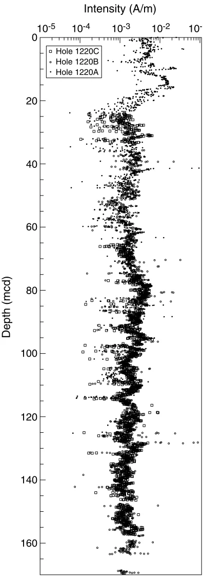
As in most of the siliceous sediments cored at previous sites, the NRM magnetization intensities were in the order of 10–1 to 10–2 A/m
and decreased to ~10–3 A/m after partial AF demagnetization (Fig. F9).
The drilling-induced overprint was mostly removed by AF demagnetiza-tion at 10 mT. Some magnetic direcdemagnetiza-tions did not reach a stable point at 20 mT and, despite a high grouping of antipodal directions, magnetiza-tion direcmagnetiza-tions of most cores did not pass a reversal test, suggesting that the characteristic remanent magnetization has not been fully isolated in these samples. Further, shobased stepwise demagnetization is re-quired to isolate the primary magnetization in these sediments, particu-larly if a precise estimate of paleolatitudinal changes in the Paleogene is intended for Site 1220.
Magnetic Polarity Stratigraphy
Site 1220 paleomagnetic data gave excellent results and a reliable record of geomagnetic reversals from the early Miocene to the early– middle Eocene. The splice of Holes 1220A, 1220B, and 1220C shows an excellent match. The VGP latitude changes were also used to splice the cores to the composite depth scale (Table T6; Fig. F10). Correlation of the obtained magnetic stratigraphy to the GPTS shows a record from Subchron C6An.1n to Chron C21n (Fig. F10). Hole 1220B is the deepest hole drilled at Site 1220, and the recovered section is correlatable to chrons from C21 (partially recovered at ~170 mcd) to C8n, at ~38 mcd. Holes 1220B and 1220C were designed to complement gaps in the Hole 1220A record, particularly in the top and middle parts of the section. Hole 1220C was particularly useful in anchoring Subchrons 6B and 6C to the GPTS, as a gap of ~3 m exists between Cores 199-1220A-3H and 4H (see also “Composite Depths,” p. 19). Data retrieved from Hole 1220B reproduced and complemented results previously obtained in Hole 1220A. The composite magnetic stratigraphy for Site 1220 faith-fully reproduces ~20 m.y. of geomagnetic polarity history.
Depth (mcd)
Intensity (A/m)
10-510-4 10-3 10-2 10-1 0 20 40 60 80 100 120 140 160 Hole 1220C Hole 1220B Hole 1220A
F9. Magnetization intensities after AF demagnetization, p. 42.
T6. Composite depths of geomag-netic reversals, p. 75.
C6An.2n C6AAr.1n C6Bn C6Cn.1n C6Cn.3n C6Cn.2n C7n C7An C8n C9n C10n C11n C12n C13n C15n C16n C17 VGP latitude (°) VGP latitude (°)
Depth (mcd) C6AAn 20 25 30 35 40 45 50 55 60 60 65 70 75 80 85 90 95 100 -80-40 0 40 80 -80 -40 0 40 80 A Chron/ subchron Chron Polarity Polarity C6An.1n Hole 1220A Hole 1220B Hole 1220C
COMPOSITE DEPTHS
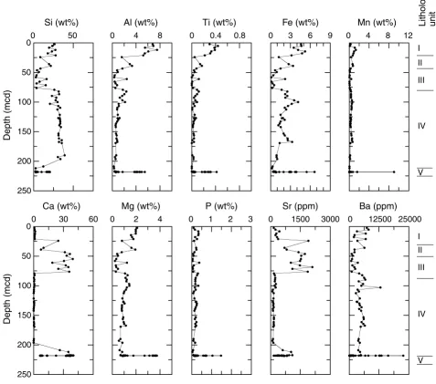
A composite section was constructed for the upper 144 mcd of Site 1220 using multisensor track (MST) and color reflectance data to deter-mine depth offsets between cores from Holes 1220A, 1220B, and 1220C (Figs. F11,F12). In Hole 1220A, MS and color reflectance data were col-lected at 2-cm intervals and gamma ray attenuation (GRA) bulk density at 4-cm intervals down to Core 199-1220A-10H, below which GRA bulk density data were acquired at 2-cm intervals. GRA bulk density data were collected at 2-cm intervals throughout cores from Holes 1220B and 1220C. P-wave velocity data were collected at 2-cm intervals through Core 199-1220A-11H and from Cores 199-1220B-4H through 13H. No P-wave data were collected in the XCB portion of Hole 1220B or in any core of Hole 1220C. Minolta spectrophotometer data were collected in all three holes at 2-cm intervals. Readings from the natural gamma ray (NGR) instrument showed only background radiation levels below ~50 mbsf. This component from the MST assemblage was only run in Hole 1220A. Disturbed intervals, as determined by visual inspec-tion of split cores, are listed in Table T7. Data from these intervals were removed prior to correlation work. Table T8 lists the offsets that were applied to cores from each hole to create a composite depth record.
Cores from Site 1220 overlap and form a continuous sedimentary se-quence down to ~144 mcd (base of Core 199-1220B-10H) (Figs. F11, F12). Between 144 and 166 mcd, cores were placed into a composite depth framework, but a continuous section could not be constructed over this interval because gaps were aligned and it was not always possi-ble to establish the true stratigraphic position of the cores. For example, Cores 199-1220B-11H and 199-1220C-10H can be correlated to each other but not to cores above or below. Figures F11 and F12 show that in this interval, between 148 and 158 mcd, the position of these cores is not constrained with respect to Hole 1220B or Hole 1220C or with re-spect to other intervals above or below in either hole.
The first cores from Holes 1220B and 1220C recovered sediments from >34 and >25 mbsf, respectively, so there is no spliced record avail-able for the interval covered by Cores 199-1220A-1H and 2H. However, this interval of predominantly radiolarian clay was recovered in the site survey piston Core EW9709-13PC (Lyle, 2000), and the bulk density and MS records between Site 1220 and the site survey core correlate well. The GRA bulk density record at Site 1220 (Fig. F11) shows several section-long intervals (~100 and 195 mcd, respectively) that have val-ues offset from the background GRA record by 0.15 g/cm3. This offset
does not correspond to any lithologic, physical, or geochemical change in the core and is an electronic artifact that occurred during data collec-tion.
Following construction of the composite depth section for Site 1220, a single continuous spliced record was assembled for the aligned cores down to ~144 mcd by patching across cores to cover gaps with data pri-marily from Holes 1220A and 1220B above 95 mcd and Holes 1220B and 1220C below 95 mcd (Table T9; Fig. F13). Intervals having signifi-cant disturbance or distortion (see Table T7) were avoided. The lithology-dependent correlation or anticorrelation of MS and GRA bulk density measurements are illustrated in Figure F14. Intervals that are dominated by varying calcium carbonate (CaCO3) content show a clear
cyclical signal as well as an anticorrelation between MS and GRA bulk density.
1.2 1.6 2.0 0 10 20 30 40 50 60 Depth (mcd)
GRA bulk density (g/cm3)
1.2 1.6 2.0 60 70 80 90 100 110 120
GRA bulk density (g/cm3)
1.2 1.6 2.0 120 130 140 150 160 170 180
GRA bulk density (g/cm3)
1.2 1.6 2.0 180 190 200 210 220 230 240
GRA bulk density (g/cm3) F11. GRA bulk density data plotted vs. composite depth, p. 45.
0 40 80120 0 10 20 30 40 50 60 Magnetic susceptibility (10-6 SI) Depth (mcd)
0 40 80 60 70 80 90 100 110 120 Magnetic susceptibility (10-6 SI)
0 40 80 120 130 140 150 160 170 180 Magnetic susceptibility (10-6 SI)
0 40 80 180 190 200 210 220 230 240 Magnetic susceptibility (10-6 SI) F12. Magnetic susceptibility data plotted vs. composite depth, p. 46.
T7. Core disturbance intervals, p. 76.
T8. Composite depth offsets, p. 77.
T9. Splice tie points, p. 78.
1.0 1.2 1.4 1.6 1.8 2.0 0
50
100
150
200
GRA bulk density
Depth (mcd)
(g/cm3)
0 40 80 120
Magnetic susceptibility (10-6 SI)
40 60 80
The Site 1220 splice can be used as a sampling guide to recover a con-tinuous single sedimentary sequence down to 144 mcd. When utilizing this splice as a sampling guide, it is advisable to overlap a few decime-ters from different holes when sampling in order to accommodate an-ticipated ongoing development of the depth scale. Stretching and com-pression of sedimentary features in aligned cores indicates distortion of the cored sequence. Because much of the distortion occurs within indi-vidual cores on depth scales of <9 m, it was not possible to align every feature in the MST and color reflectance records. However, at crossover
points along the splice (Table T9), care was taken to align highly
identi-fiable features from cores in each hole. Postcruise work will establish a detailed correlation between holes by establishing a revised meters composite depth scale that allows differential stretching and squeezing within cores, following Hagelberg et al. (1992).
SEDIMENTATION AND ACCUMULATION RATES
All the principal biostratigraphies, plus an extensive set of over 60 paleomagnetic reversals, are defined in Holes 1220A, 1220B, and 1220C
(Tables T10,T11). Paleomagnetic reversals are used to calculate the
av-erage linear sedimentation rates (LSRs) for Site 1220 through most of the section. The first reliable paleomagnetic reversals are found in Core 199-1220A-3H, along with the youngest radiolarian events, and extend through the section recovered by APC methods. The age of the base of the hole is based on the identification of the BEE in Section
199-1220B-20X-2 (Table T11).
Calcareous nannofossils and radiolarians are present in the
upper-most part of the fossiliferous section in the lower Miocene (Fig. F15).
From the lower Miocene to the base of the Oligocene, both nannofos-sils and radiolarians were useful in establishing age control. In most of
the Eocene, only radiolarians are present (Fig. F15), although both
nan-nofossils and foraminifers are found in the chalks at the very base of the section of lithologic Unit IV.
Based on a simple linear interpolation from the sediment surface (as-sumed to be zero age) and the first identifiable paleomagnetic reversal
(Tables T10, T11), the clays of lithologic Unit I (see
“Lithostratigra-phy,” p. 6) have an LSR near 1 m/m.y. Piston Core EW9709-13P (Lyle, 2000), taken in the survey area, can be correlated to the density records
of Site 1220A (Fig. F16). By mapping the density record of the upper
part of Hole 1220A (Tables T10,T11) onto the density record of piston
Core EW9709-12P, we can determine the LSR of the piston core relative to the assumed constant sedimentation rate of Hole 1220A. This com-parison indicates an interval of relatively rapid sedimentation in the
piston core near 15 Ma (Figs. F16,F17). Above this interval, the LSR of
the piston core is less than half that of Hole 1220A. Below the relative peak in LSR, the piston core has about the same accumulation rate as
assumed for the upper part of Hole 1220A (Fig. F17).
The LSR at Site 1220 in the alternating siliceous and calcareous clays of lithologic Units II and III reaches ~5.5 m/m.y. in the Oligocene part
of the section (Tables T10,T11; Fig. F15). This sedimentation rate
con-tinues through the E/O boundary into the upper Eocene with no signif-icant change, despite the disappearance of carbonate from the Eocene sediments. A second maximum in LSR of ~8.3 m/m.y. is present in the silica-rich middle Eocene radiolarian ooze of lithologic Unit IV (Fig.
F15). The LSR apparently drops slightly (to ~6.6 m/m.y.) near the top of
0 4080 120
1.2 1.6 2.0
0 10 20 30 40 50 60
GRA bulk density
Depth (mcd)
Magnetic susceptibility
(10-6 SI)
(g/cm3)
0 20 40
1.2 1.6 2.0
60 70 80 90 100 110 120
GRA bulk density Magnetic susceptibility (10-6 SI)
(g/cm3)
0 20 40
1.0 1.2 1.4
120 130 140 150 160 170 180
GRA bulk density Magnetic susceptibility (10-6 SI)
(g/cm3)
0 40 80
0 1 2
180 190 200 210 220 230 240
GRA bulk density Magnetic susceptibility
(10-6 SI)
(g/cm3)
F14. Spliced records of GRA bulk density and magnetic suscepti-bility, p. 48.
0 50 100 150 200 250
0 10 20 30 40 50 60
Depth (mcd) Age (Ma) 0.98 m/m.y. 2.74 m/m.y. 3.82 m/m.y. 5.47 m/m.y. 8.31 m/m.y. 6.57 m/m.y. Nannofossils Radiolarians Foraminifers Paleomagnetic reversal
F15. LSR and chronostratigraphic markers, p. 49.
T10. Paleomagnetic events, p. 79.
T11. Nannofossils, foraminifers, and radiolarian events, p. 80.
1.0 1.1 1.2 1.3 1.4
1.0 1.1 1.2 1.3 1.4 1.5 1.6
0
5
10
15
20
Site 1220 density (g/cm3)
EW9709-13P density (g/cm3)
Depth (mcd)
EW9709-13P Site 1220
the lower Eocene with the appearance of the first significant chert lay-ers.
LSR data may be combined with the dry bulk density (DBD) data (see
“Physical Properties,” p. 24) (Table T16) to determine the bulk mass
accumulation rates (MARs) of the sediments (Table T12). Sediment with an LSR of 1.0 cm/k.y. and a DBD of 1.0 g/cm3 will have an MAR value of
1.0 g/cm2/k.y. The observed values are rarely this high, so we report the
data as milligrams per square centimeter per thousand years (mg/cm2/
k.y.).
MAR values are low in lithologic Unit I, generally <75 mg/cm2/k.y.
(Fig. F18). Lithologic Unit II, dominated by siliceous ooze, accumulates at flux rates up to 100 mg/cm2/k.y. Maximum flux rates of 400–500 mg/
cm2/k.y. occur in lithologic Unit III, the very light brown nannofossil
ooze of early Oligocene age. Unit IV, dominated by radiolarian ooze and radiolarite, has much lower MARs of ~160 mg/cm2/k.y. in the upper
portion to ~300 mg/cm2/k.y. in the period between ~40 and 46 Ma. The
basal chalk of Unit V accumulated at rates of ~400–600 mg/cm2/k.y.
GEOCHEMISTRY
Interstitial Water Geochemistry
We collected interstitial waters from 11 samples from Site 1220 at in-tervals of approximately one sample every core for the first six cores and every third core thereafter (Table T13; Fig. F19). Eight samples from Hole 1220A, at depths ranging from 4.45 to 110.45 mbsf, and three samples from Hole 1220B, at depths ranging from 125.89 to 173.55 mbsf, together comprise the interstitial water profile for Site 1220. Chemical gradients in the interstitial waters at Site 1220 primarily re-flect relatively limited organic matter diagenesis, dissolution of bio-genic silica, little carbonate, and possibly diffusive influence of reac-tions in the underlying basalt.
Chlorinity, as measured by titration, increases with depth from 554 mM at 4.45 mbsf to a mid-depth maximum of 566 mM at 80.45 mbsf (Fig. F19). This pattern is very similar to the chlorinity pattern at Site 1219. The lower than average seawater value of interstitial water at shal-low sediment depth (4.45 mbsf) at this site is consistent with the chlo-rinity of modern Pacific bottom waters (~542 mM). Sodium concentra-tions determined by charge balance were on average 2.4% lower than those measured by ion chromatograph and are consistent overall with the chlorinity values (Table T13). Sodium concentrations determined by charge balance are low (477mM, as compared to the average sea-water value of 480 mM) at 4.45 mbsf and increase to a middepth maxi-mum (487 mM) at 80.45 mbsf. Salinity, as measured by a handheld re-fractometer, varies slightly from 35.0 in the shallower part of the hole (4.45–51.95 mbsf) to 35.5 in the deeper part of the hole (80.45–173.55 mbsf).
Alkalinity generally decreases with depth from 4.45 to 173.55 mbsf. The pH varies between 7.14 at the seafloor (4.45 mbsf) to 7.39 at the bottom of the profile (173.55 mbsf). Like all other Leg 199 sites, sulfate concentrations are high (28.6 ± 1 mM) throughout the profile, indicat-ing little oxidation of labile organic matter. Ammonium, a byproduct of organic matter degradation, is present in extremely low levels (≤5 µM).
Dissolved silica concentrations increase with depth, from 556 µM at 4.45 mbsf to ~900 µM at 154.45 mbsf. These high interstitial water
sil-0 5 10 15 20 25 30
0 5 10 15 20
Depth (mcd) Age (Ma) 0.98 m/m.y. 0.40 m/m.y. 2.25 m/m.y. 1.91 m/m.y. 0.98 m/m.y.
Paleomagnetic reversals (Site 1220) Stratigraphic ties (Site 1220 to Core EW9709-13P)
F17. Age vs. depth plots for Site 1220 and Core EW9709-13P, p. 51.
T12. Depths, ages, rates, and fluxes of sediments, p. 81.
0 10 20 30 40 50 60
0 100 200 300 400 500 600 700
Age (Ma)
MAR (mg/cm2/k.y.)
F18. MARs of sediments, p. 52.
T13. Interstitial water data, p. 83.
540 555 570 0 40 80 120 160 200 Cl (mM) Depth (mbsf)
2 3 4 Alkalinity (mM)
25 30 35 SO4 (mM)
0 5 10 NH4 (µM)
0 600 1200 H4SiO4 (µM)
0 30 60 Ca and Mg (mM)
5 10 15 0 40 80 120 160 200 K (mM) Depth (mbsf)
0 0.5 1 Ba (µM)
400 600 800
B (µM) 15 30
Li (µM) 50 75 100
Sr (µM)