JOURNAL OF FOREST SCIENCE, 62, 2016 (7): 337–344 doi: 10.17221/110/2015-JFS
Predicting the earthwork width and determining
the annual growth loss due to forest road construction
using artificial neural network and ArcGIS
S. Peyrov
1, A. Najafi
1, A.R. Nourodini
21Department of Forestry, Faculty of Natural Resources and Marine Sciences, Tarbiat Modares University, Tehran, Iran
2Department of Forestry, Faculty of Natural Resources, University of Guilan, Rasht, Iran
ABSTRACT: The area of forest destruction as well as the annual growth loss due to road construction before con-structing a road was predicted. To do this, road cross sections of 88 points along the 10 km proposed road were pre-dicted using Multilayer Perceptron Neural Network with two input parameters of hillside slope and rock share within MATLAB software. Then according to the predicted width, the area of road earthwork as well as the area of roadside with a 10 m width was calculated in ArcGIS software. Finally, by overlaying the inventory network layer on the road map and by knowing the annual growth (m3) for each plot the growth loss of the area of road earthwork was calculated
and one-third of the annual growth increment was considered to calculate the growth loss of the roadside. According to the results, for the construction of a 10 km long road in the region, 12.98 ha of forest area is destructed due to road construction, of which 5.36 ha is destructed resulting from earthwork operations and 7.61 ha occurs in the roadside and its growth is influenced by road construction. With the construction of the road, in total, 32.606 m3 of growth will
be lost annually, of which 22.221 m3 is due to road earthwork that is completely removed from the forest annual growth
cycle and 10.384 m3 of the growth loss belongs to the roadside which is decreased resulting from road construction.
Keywords: area of road earthwork; hillside slope; roadside; rock share
This study was carried out at the Training and Research Forest of Tarbiat Modares University, watershed 46, Mazandaran province, Iran. Forest roads are the most essential component of scien-tific forestry which play an important role in timber transportation as well as in the use of other forest services (Majnounian et al. 2012). Despite the nu-merous undeniable advantages, constructing roads requires strip cuttings and harvesting trees on the route, so it causes extensive long-term changes in terms of entering sunlight, moisture, as well as soil physicochemical properties because forest trees are harvested in micro- and meso-scales creating a corridor and diversity and density of plant com-munities change depending on the magnitude and intensity of changes (Najafi et al. 2011). Regard-less of the trees which are cut and completely elimi-nated from the production cycle due to earthworks
annual growth loss of woody species resulting from road construction should be at a minimum level.
To achieve this, predicting the surface area of the forest that will be influenced by road earthwork op-erations as well as predicting the annual growth loss due to constructing a road before its construction it could be effective in selecting a more appropriate de-sign alternative and decreasing the destruction area and reducing economic costs and environmental damage. In the mountain forests, natural slope of the hillside as well as rock share are important natural factors influencing the road cross section thereby the road earthwork area, thus these factors are used in estimating the earthwork operations (Potočnik 2003; Peyrov et al. 2014). Thus, by knowing the for-est annual growth, the annual growth loss due to the road construction can be calculated before perform-ing road construction operations. Today, in design-ing and constructdesign-ing roads, problems and deficien-cies of traditional methods on the one hand, and the change in forest management objectives and the introduction of environmental and economic crite-ria have resulted in the application of new methods of higher capabilities, so it has led the designers to use the computer and then GIS (geographic infor-mation system) (Sarikhani, Majnounian 2012). A possibility of designing and evaluating the forest road network variants using GIS and field investiga-tions (Alizadeh et al. 2011), determining the proper method of preliminary forecasting of mountain and forest roads using GIS (Raafatnia et al. 2006), plan-ning forest road alignment using the shortest path al-gorithm and geographic information system (Imani et al. 2012), and forest road network planning based on environmental, technical and economic consid-erations using GIS and analytic hierarchy process (Shahsavand et al. 2011) are among studies that have been carried out on forest roads by using GIS.
Peyrov et al. (2016) studied the effects of phys-iographic parameters on the road cross section in mountain forests. Results showed that the param-eters including hillside slope and rock base had a significant effect on the cross section.
Kokmila et al. (2009) mapped the forest func-tions using GIS at a plateau area, Laos. In this study they presented the process of classification of for-est functions for improving forfor-estry agriculture and livelihood standard in Champasak province, Bolivian plateau area. It is arable land supporting agriculture and protecting watersheds. Geographic information system was used to classify and map three functions, namely conservation forest, pro-tection forest and production forest. These func-tions were linked for planning watershed
manage-ment, improving forestry, agriculture and water supply system in rural forest areas.
Karlsson et al. (2006) described a decision sup-port system called RoadOpt for the planning of for-est road upgrading. A case study from a major Swed-ish company is presented. In this study the planning horizon is about one decade. The system uses a GIS-based map user interface to present and analyse data and results. Two important modules are the Swedish road database, which provides detailed information about the road network, and an optimization mod-ule consisting of a mixed integer linear program-ming model.
Potočnik (2003) assessed the rock base and hill-side natural slope as some factors influencing the road formation width, and results showed that the road formation width could increase up 80% more in a steeper terrain (compared to a gentle terrain slope) and 20% less on a solid rock base regardless of the ter-rain slope. It varies between 5.4 m (solid rock base, gentle slope) and 11.4 m (soft rock base, steep slope).
In the case of modelling and forecasting methods, numerous techniques in different sectors of forestry practice have been employed and parallel to the pre-vious conventional models today a newer method of artificial neural network has successfully been used for prediction. Predicting the road cross section of forest roads using an artificial neural network (Pey-rov et al. 2014), tree density estimation of forests by terrain analysis and artificial neural network (Ghan-bari et al. 2009), applications of radial basis neural networks for area forest (Castellanos et al. 2007) and mapping the tropical forest structure in south-eastern Madagascar using remote sensing and artifi-cial neural networks (Ingram et al. 2005) are among researches conducted in this area.
The main purpose of this study was to estimate the forest growth loss resulting from road con-struction using GIS and artificial neural network before road construction which could significantly influence the environmental and economic evalu-ation of different variants of forest road network.
MATERIAL AND METHODS
Study area. The study area is located at the
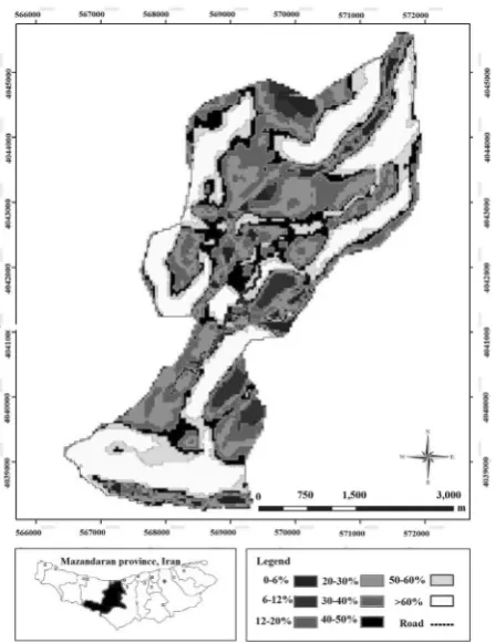
Training and Research Forest of Tarbiat Modares University, watershed 46, Mazandaran province between 51°41'05'' to 51°48'12''E and 36°29'14'' to 36°33'18''N with minimum height and maximum elevation of 140 and 1,720 m, respectively (Fig. 1).
Preparation of informational layers. Maps of
topo-graphic maps with a scale of 1:25,000 were used in ArcGIS (Version 9.3, 2015) system for mapping the digital terrain model, then the digital elevation model was classified and the slope raster layer was prepared. A hillside slope map was classified in 0–6, 6–12, 12–20, 20–30, 30–40, 40–50, 50–60, and > 60% classes, in which the proposed verified road is visible on this layer (Fig. 2).
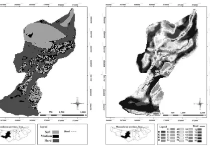
Raster layers of the rock share were prepared from digital terrain model maps and were classi-fied into three rock classes: soft, medium and hard classes (Ghajar et al. 2012) (Fig. 3).
Integration of layers. Prepared maps of rock
share and hillside slope were integrated as a raster layer with a new layer containing 24 classes (Fig. 4). Then the layer of the proposed road with 10 km length was overlaid on the integrated layer contain-ing a number of 18 classes integrated from the slope and rock share. Given the changes in classes of the integrated layer along the road, a number of 88 points were selected. Then the percent of hillside slope and rock share was extracted for each point.
Artificial neural network: given that the param-eters of terrain hillside slope and rock share are the most important factors affecting the road cross sec-tion of forest roads, at this step by having informa-tion about these parameters, the road cross secinforma-tion (Fig. 5) at each point was predicted using Multi-layer Perceptron Neural Network within MATLAB software (Version 7.6, 2014) (Peyrov et al. 2014). In this modelling, factors of hillside slope and rock share were considered as input parameters and road cross section was considered as output pa-rameter of the model. In the next step, the area of road earthwork as well as the area of roadside with a 10 m width was calculated in ArcGIS system ac-cording to the predicted widths.
Collecting samples. Sampling was performed
using a randomized systematic sampling method.
The area of sampling plots was set at 1,000 m2. In
[image:3.595.67.446.55.302.2]each plot, some characteristics including species Fig. 1. Study area, Mazandaran prov-ince, Iran
[image:3.595.64.288.432.723.2]type, DBH, tree height and density for all trees were measured. Then using a two-factor volume table of the studied forest, tree volume and annual growth volume in the plots were obtained. Final-ly, by putting the inventory network layer and by
knowing the annual growth (m3) for each plot the
growth loss of the area of road earthwork was cal-culated and one-third of annual growth increment was considered to calculate the growth loss of the roadside.
RESULTS
Maps of the two parameters of hillside slope and rock share were separately integrated with the road map suggesting the amount of road that
oc-curs in different classes of slope and rock share (Fig. 2, Table 1). The results show that the maxi-mum length of the road had crossed from the slope classes 30–40, 40–50, and > 60%, as well as the maximum length of the road had crossed from the medium rock class.
Integration of road maps with maps of hillside slope and rock share
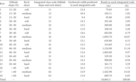
At this step, by integrating the maps of road, hillside slope and rock share, information for each profile was obtained. The amount of road occur-ring in different integrated classes obtained from the two parameters of hillside slope and rock share was calculated (Table 2).
Predicting the earthwork width
According to Table 2, by combining the two in-put parameters of hillside slope and rock share, earthwork width in 18 different integrated classes containing the road network was predicted using Multilayer Perceptron Neural Network.
[image:4.595.71.323.60.350.2]According to the results, the slope classes of 40–50 and 50–60% had the highest earthwork Fig. 3. Classification map of the rock share and the
pro-posed road
[image:4.595.306.529.62.343.2]Fig. 4. Classification map of rock share and hillside slope integrated
[image:4.595.64.287.630.736.2]width, also soft and medium classes of rock share had the highest earthwork width.
Determining the areas of earthwork operations and the roadside
Given the width of earthwork, buffer zone of earthwork operations and by considering the width of the roadside as 10 m for each side, the roadside buffer zone was calculated in GIS (Table 3).
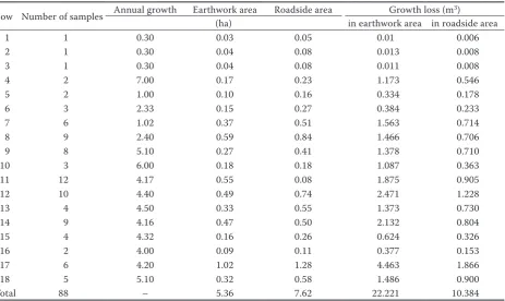
Determining the annual growth loss due to road construction
The layer of plot centres was integrated with the layer of the buffer zone of earthwork and roadside
and taking into account the annual growth in hect-ares, the growth loss in the earthwork area was calculated and in the roadside area the growth loss was considered as one-third of forest normal an-nual growth (Table 3). According to the results, the slope classes of 40–50 and 50–60% had the high-est earthwork width, also soft and medium classes of rock share had the highest earthwork width. In parts with higher annual growth, a higher growth volume is lost.
DISCUSSION AND CONCLUSIONS
[image:5.595.65.532.72.202.2]Information on the parameters of hillside slope and rock share was prepared in the study area in or-der to achieve the objectives of the study. The ex-tracted information indicated that the maximum
Table 2. Predicted earthwork width and road length in different classes of combined layers of hillside slope and rock share
Roads in each integrated code Earthwork width predicted
in each integrated code Integrated class code (hillside
[image:5.595.64.531.473.754.2]slope and rock share) Rock share Hillside slope (%) Row (%) (m) 0.8 79.65 12.4 11 soft 12–20 1 1.02 103.11 10.4 12 medium 12–20 2 0.95 95.80 9.4 13 hard 12–20 3 2.89 291.40 14.3 21 soft 20–30 4 2.08 209.80 12.5 22 medium 20–30 5 3.28 330.10 11.0 23 hard 20–30 6 6.79 683.00 14.6 31 soft 30–40 7 10.87 1,093.70 13.8 32 medium 30–40 8 6.15 618.80 13.1 33 hard 30–40 9 3.13 314.69 15.5 41 soft 40–50 10 11.18 1,124.90 13.6 42 medium 40–50 11 9.97 1,003.80 13.4 43 hard 40–50 12 5.36 539.50 16.3 51 soft 50–60 13 8.94 900.00 14.3 52 medium 50–60 14 3.59 361.73 13.0 53 hard 50–60 15 1.72 172.75 16.3 61 soft > 60 16 14.43 1,452.90 15.9 62 medium > 60 17 6.85 689.70 11.0 63 hard > 60 18 100.00 10,065.3 – – – Total
Table 1. The amount of roads that occurs in different classes of hillside slope and rock share
amount of road occurred in the hillside slope classes of 30–40, 40–50, and > 60% and the medium class of rock share (Table 1). Designing the road in areas with slopes higher than 50% can significantly increase the volume of earthwork, thereby increase economic and environmental costs (Imani et al. 2012). Pey-rov et al. (2016) have reported that among the effec-tive parameters in relation to the road cross section the slope angle is the most important. The reason for the road to occur in areas with high slope classes lies in the specific topographic conditions of the study area that is often characterized by hillside slope classes higher than 30% (Fig. 2). In the case of the parameter rock share it can be noted that the study area is often characterized by the medium and hard classes of rock share and given the fact that the road occurs in a rocky class makes the construction oper-ations more difficult with increased economic cost, therefore, when designing the road it should occur in the medium class. Certainly, other environmen-tal factors such as considering the low and unstable hillside have also contributed to the designing of the road. Peyrov et al. (2016) stated that the amount of rock base in soil is considered as a decisive factor for determining the road cross section and road con-struction project, so that by decreasing the rock base the road cross section increases while by increasing the rock base the operation of cutting the trenches is more difficult, which in turn decreases the road cross section.
The earthwork width obtained by the method of artificial neural network in 18 integrated classes of hillside slopes and rock share showed that the larg-est earthwork width (16.3 m) was found for profiles with soft soil and slope of 50–60% as well as for profiles with soft soils and slopes greater than 60%. With increasing the slope, the length of the cut-slope trench increases and consequently the length of the cross trench as well as road cross section in-crease, particularly in the classes with soft soil that are lacking the rock which prevents an increase in the road cross section (Gorton 1985; Sedlak 1985; Hay 1996; Potočnik 2003). The lowest road cross section (9.4 m) was found in rocky profiles with slope of 12–20% (Table 2).
As mentioned above, by constructing a 10 km long road in the area, 5.36 ha of forest area occurs under earthwork operations and 7.62 ha of forest area is affected by the road construction as roadside area. The growth loss due to the road earthwork
ac-counts for 22.221 m3·yr–1 that would be completely
out of the forest growth cycle, while the growth loss
in the roadside area is estimated to be 10.384 m3.
There is no doubt that appropriate roads should be constructed for the development of different parts of the country, but the important point is that the road construction in a forest should be performed by taking into account technical issues and accord-ing to correct criteria and indicators as well as con-sidering the environment conservation, conserv-Table 3. Growth loss in the earthwork and roadside areas
Growth loss (m3)
Roadside area Earthwork area
Annual growth Number of samples
Row
in roadside area in earthwork area
[image:6.595.69.533.72.348.2]ing forests, rangelands, water and soil resources (Nekooimehr 2006), so modelling helps managers and planners to better understand the current con-ditions and improve the concon-ditions predicted for the future (Lotfalian, Parsakhoo 2012). Since in this study a qualitative criterion of growth condi-tions of road areas is also considered in addition to the physiographic quantitative criteria, the results can be used to evaluate the forest road network variants in terms of economic and environmental costs. It is noteworthy that the results of these re-searches are directly correlated with the accuracy of spatial data in the studied regions. Thus, the pro-vision of information and thematic maps with high accuracy is necessary for forests of northern Iran in order to achieve the desired results by applying these maps as well as new methods of designing and evaluation, which could be considered as a ba-sis for the protection, restoration and development of forests (Majnounian et al. 2007).
References
Aikens L.M., Ellum D., McKenna J.J., Kelty J.M., Ashton S.M. (2007): The effects of disturbance intensity on temporal and spatial patterns of herb colonization in a southern New England mixed-oak forest. Forest and Management, 252: 144–158.
Alizadeh S.M., Majnounian B., Darvishsefat A.A. (2011): Pos-sibility ofdesigning and evaluation of forest road network vari-ants using GIS and field investigations (Case study: Kheiroud forest – Chelir district). Journal of Forest and Wood Products (Iranian Journal of Natural Resources), 63: 399–408. Castellanos A., Martinez Blanco A., Palencia V. (2007):
Ap-plications of radial basis neural networks for area forest. International Journal “Information Theories & Applica-tions”, 14: 218–222.
Ghajar I., Najafi A., Torabi S.A., Khamehchiyan M., Boston K. (2012): An adaptive network-based fuzzy inference system for rock share estimation in forest road construc-tion. Croatian Journal of Forest Engineering, 33: 313–328. Ghanbari F., Shataee S., Dehghani A.A., Ayoubi S. (2009):
Tree density estimation of forests by terrain analysis and artificial neural network. Journal of Wood & Forest Science and Technology, 16: 25–42.
Godefroid S., Koedam N. (2004): The impact of forest paths upon adjacent vegetation: Effects of the path surfacing material on the species composition and soil compaction. Biological Conservation, 119: 405–419.
Gorton F. (1985): Praxis und Kosten einer landschaftss-chonenden Bauausführung von Forststrassen. Allgemeine Forstzeitung, 96: 241–244.
Hay R. (1996): Forest road design. In: Proceedings of the Seminar on Environmentally Sound Forest Roads and Wood Trans-port, Sinaia, June 22, 1996: 17–22.
Imani P., Najafi A., Ghajar E. (2012): Planning forest road alignment using ashortest path algorithm and geographic information system. Iranian Journal of Forest and Poplar Research, 20: 460–471.
Ingram J.C., Dawson T.P., Whittaker R.J. (2005): Mapping tropical forest structure in southeastern Madagascar us-ing remote sensus-ing and artificial neural networks. Remote Sensing of Environment, 94: 491–507.
Karlsson J., Rönnqvist M., Frisk M. (2006): A decision sup-port system for road upgrading in forestry. Scandinavian Journal of Forest Research, 21: 5–15.
Kokmila K., Lee W.K., Badarch O., Kim S.R., Choi S., Park S. (2009): Mapping forest functions using GIS at plateau area, Laos. Forest Science and Technology, 5: 57–61.
Lotfalian M., Parsakhoo A. (2012): Forest Roads Network Planning. Tehran, Aeezh: 153.
Majnounian B., Abdi E., Darvishsefat A.A. (2007): Planning and technical evaluating of forest road networks from ac-cessibility point of view using GIS (Case study: Namkhane district, Kheyroud forest). Journal of the Iranian Natural Resources, 60: 907–919.
Majnounian B., Alizadeh S.M., Darvishsefat A.A., Abdi E. (2012): Evaluating of estimation of cut and fill operations using GIS and field measurement. Watershed Management Research Journal (Pajouhesh & Sazandegi), 87: 64–69. Najafi A., Hossieni S.M., Ezzati S., Torabi M., Fakhari M.A.
(2011): Comparison of regeneration and biodiversity of trees on cut and fill edges of forest road (Case study: Cha-mestan and Lavige forests, Noor). Iranian Journal of Wood & Forest Science and Technology, 17: 139–152.
Nekooimehr M., Rafatnia N., Raisian R., Jahanbazi H., Talebi M., Abdolahi K. (2006): Impact of road construction on for-est dfor-estruction in Bazoft region. Iranian Journal of Forfor-est and Poplar Research, 14: 228–243.
Olander L.P., Scatena F.N., Silver W.L. (1997): Impacts of disturbance initiated by road construction in a subtropical cloud forest in the liquidly experimental forest, Puertorico. Forest Ecology and Management, 109: 33–49.
Peyrov S., Najafi A., Alavi S.J. (2014): Prediction of forest roadway using artificial neural network and multiple linear regressions. Journal of Forest Sustainable Development, 1: 285–296.
Peyrov S., Najafi A., Nourizadeh J.(2016): Evaluating the ef-fects of physiographic parameters on the road cross section in mountain forests (Case study: northern forests of Iran). Journal of Forest Science, 62: 1–7.
Potočnik I. (2003): Forest road formation width as an indi-cator of human impact on forest environment. Ekológia, 22: 298–304.
for-est roads using GIS. Iranian Journal of Forfor-est and Poplar Research, 14: 244–257.
Sarikhani N., Majnounian B. (2012): Guide of plan, perform and exploitation of forest roads. Tehran, Program and Budget Organization of Iran: 220.
Sedlak O. (1985): Forest road planning, location and con-struction techniques on steep terrain. In: Logging and Transport in Steep Terrain. FAO Forestry Paper No. 14. Rome, FAO: 37–54.
Shahsavand Baghdadi N., Pir Bavaghar M., Sobhani H. (2011): Forest road network planning based on environmental, technical and economic considerations using GIS and AHP (Case study: Baharbon district in Kheyroud forest). Iranian Journal of Forest and Poplar Research, 19: 381–395.
Received for publication December 2, 2015 Accepted after corrections June 24, 2016
Corresponding author: