HAO, Jiang and CHING CHIUAN, Yen
Available from Sheffield Hallam University Research Archive (SHURA) at:
http://shura.shu.ac.uk/527/
This document is the author deposited version. You are advised to consult the
publisher's version if you wish to cite from it.
Published version
HAO, Jiang and CHING CHIUAN, Yen (2009). Wayfinding in Complex Multi-storey
Buildings: A vision-simulation-augmented wayfinding protocol study. In:
Undisciplined! Design Research Society Conference 2008, Sheffield Hallam
University, Sheffield, UK, 16-19 July 2008.
Copyright and re-use policy
See
http://shura.shu.ac.uk/information.html
Wayfinding in Complex Multi-storey Buildings:
A vision-simulation-augmented wayfinding protocol study
Jiang Hao Department of Architecture, National University of Singapore
Yen, Ching Chuian (Dr.), Department of Architecture, National University of Singapore
Abstract
Wayfinding in complex multi-storey buildings often brings newcomers and even some frequent visitors uncertainty and stress. However, there is little understanding on wayfinding in 3D structure which contains inter-storey and inter-building travelling.
This paper presents the method of vision-simulation-augmented wayfinding protocol for the study of such 3D structure to find its application from
investigating pedestrians’ wayfinding behaviour in general-purpose complex multi-storey buildings. Based on Passini’s studies as a starting point, an
exploratory quasi-experiment was developed during the study and then conducted in a daily wayfinding context, adopting wayfinding protocol
method with augmentation by the real-time vision simulation. The purpose is to identify people’s natural wayfinding strategies in natural settings, for both frequent visitors and newcomers. It is envisioned that the findings of the study can inspire potential design solutions for supporting pedestrian’s wayfinding in 3D indoor spaces.
From the new method developed and new analytic framework, several
findings were identified which differ from other wayfinding literature, such as (1) people seem to directly “make sense” of wayfinding settings, (2) people could translate recurring actions into unconscious operational behaviours, and (3) physical rotation and constrained views, instead of vertical travelling itself, should be problems for wayfinding process, etc.
Keywords
Wayfinding Protocol; Real-time Vision Simulation; 3D Indoor Space; Activity Theory; Structure of Wayfinding process
1.Introduction
This experimental study reported is part of a PhD research, i.e. applying “on-the-move” technology in the design of wayfinding supporting artefacts. Before this study, a review1
of 67 academic papers about the design of pedestrian navigation device has shown that, most of studies focused on relevant wayfinding techniques and their implementations. It implied that current studies in designing new artefacts that could support pedestrian wayfinding are mostly emphasizing on “how” issues but ignoring to discuss
“why” these techniques could really help, or just taking some arbitrary assumptions, such as the use of maps can help orientation and wayfinding, for granted.
However, thoughtful designers value the question of “why” prior to and beyond “how” (ICSID, 2001). This study disregards the take-for-granted assumptions in those technical papers, and turned to explore the situations from a design perspective, i.e. the relevant contexts of wayfinding in 3D indoor space as well as people’s already gained competence, which are supposed to benefit from wayfinding studies.
1.1 Brief Review of Wayfinding Studies
Wayfinding studies were usually conducted in the fields of environmental psychology and environmental graphic design, investigating wayfinding behaviours, i.e. “how living organisms make their way from an origin to a destination” (Carpman & Grant, 2001), in addition to the relevant effects and their architectural applications.
1.1.1 Passini’s Studies of Wayfinding in Architecture
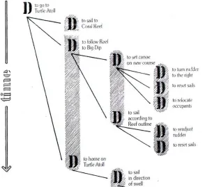
Romedi Passini, an architect and environmental psychologist, has conducted remarkable and widely-cited works in the fields of human wayfinding research (Arthur & Passini, 1992; Passini, 1984a, 1984b, 2002). He mainly focused on general patterns of wayfinding behaviours and his research showed that wayfinding in complex multi-storey buildings often brings newcomers and even some frequent visitors uncertainty and stress (Arthur & Passini, 1992). In particular, he considered wayfinding as “spatial problem solving”; and, based on his empirical studies in Montreal’s downtown commercial centers, he proposed that the general wayfinding process could be decomposed into three major sub-processes: decision-making, decision-execution, and
Fig 1: Decision Diagram adopted from Passini (1984a, p.156)
1.1.2 Other Studies of Wayfinding in Architecture
Beside Passini’s seminal research, there are some other studies focusing on wayfinding in architecture, in particular indoor wayfinding. However, most of these studies were in specific settings, such as hospitals (Carpman & Grant, 1993; Carpman, Grant, & Simmons, 1985) and airports (Raubal & Egenhofer, 1998; Raubal, Egenhofer, Pfoser, & Tryfona, 1997; Raubal & Worboys, 1999). In such settings, the routes of pedestrians are more or less predefined. In airport, for example, people follow the rigid procedures from the entrance of
departure hall, to check-in point, passport control, duty-free area, and further to gate area, and finally end at the correct gate. However, the daily
wayfinding for general purpose, such as wayfinding in multifunctional buildings in universities or department store, in which the starting place and destination for individual wayfinding tasks are not predetermined, is under-explored by researchers.
In addition, few studies have addressed the issues of wayfinding in 3D structure. In general, lots of wayfinding studies were conducted in outdoor open space or horizontal plane of isolated floor levels (e.g. Hölscher, Vrachliotis, &
Meilinger, 2005), not explicitly discuss vertical travelling. Some studies (Hölscher, Meilinger, Vrachliotis, Brosamle, & Knauff, 2004; Hölscher, Mellinger, Vrachliotis, Brosamle, & Knauff, 2006; Hölscher et al., 2005; Soeda, Kushiyama, & Ohno,
Level
Ultimate
Decision
Level
Intermediary
Decision
Level
Immediate
[image:5.595.141.529.103.484.2]Decision
1997) suggested that the inter-storey vertical travelling is considered as one of the major challenges of keeping orientation.
To sum up, Passini’s studies offered us a well-settled starting point. However, two issues which were not explicitly articulated by Passini had been identified for further investigation: (1) the wayfinding in general-purpose settings, i.e. people often start from any place to any destination – and (2) wayfinding in 3D structure, especially how inter-storey and inter-building travelling influences wayfinding process.
1.2 Protocol Analysis as a Means of Wayfinding Studies
The introduction of protocol analysis method to wayfinding research is another major contribution from Passini (1984b). Many researchers followed his
wayfinding protocol to conduct their research, such as Ottosson (1987), Raubal (Raubal et al., 1997), and Hölscher (Hölscher et al., 2004, 2006). Protocol analysis is a method of using participant’s self-reported verbal description as major data source in many research areas of psychology, education and cognitive science (Cross, Christiaans, & Dorst, 1996; Ericsson & Simon, 1993). Ericsson and Simon (1993) identified that there are two types of verbal protocols: (1) concurrent verbalization, which is real-time verbally reported about their thought process while participants are performing the task; and (2) retrospective verbalization, which is reported after completion of the task, often in a temporal sequence. The latter report is accessed from durable memory while the information of former is mainly retrieved from short-term working memory (STM).
For the concurrent verbal reports, Ericsson and Simon (1993) further clarified them in 3 levels. The 1st level verbalization is “talk aloud” or direct verbalization,
i.e. simply vocalize the “covert articulatory or oral encodings”. The 2nd and 3rd
levels are normally called “encoded” verbalization. The 2nd level verbalization
is also known as “think aloud” verbalization, which involves “description or rather explication of the thought content” (Ericsson & Simon, 1993). To report contents of images or actions, people need an encoding process to translate non-audio coded information into audio coded one. Researchers generally assumed that no changes occur in the cognitive process, since no new information is brought into STM. However, the 3rd level encompasses
interpretations of people’s thought process and such additional interpretative process changes the structure of thought process.
2. Research Methodology
2.1 Pilot Studies
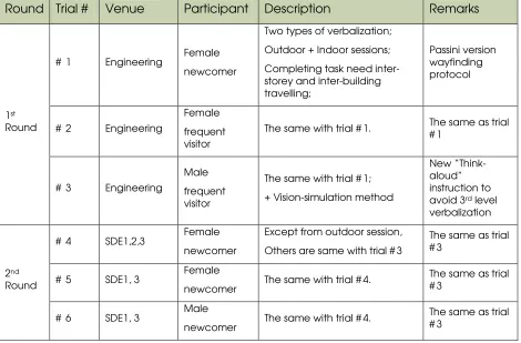
This vision-simulation-augmented wayfinding protocol study is the result of iterative design of research methods. Before the formal quasi-experiment2
[image:7.595.100.570.245.554.2], a range of pilot “experiments” (6 trials in total as shown in Table 1) in “modify-based-on-last-trial” mode were conducted, in order to derive an appropriate “experiment” procedures.
Table 1: Brief summary of pilot studies
Round Trial # Venue Participant Description Remarks
# 1 Engineering Female newcomer
Two types of verbalization;
Outdoor + Indoor sessions;
Completing task need inter-storey and inter-building travelling;
Passini version wayfinding protocol
# 2 Engineering
Female
frequent visitor
The same with trial # 1. The same as trial # 1
1st Round
# 3 Engineering
Male
frequent visitor
The same with trial # 1;
+ Vision-simulation method
New “Think- aloud” instruction to avoid 3rd level verbalization
# 4 SDE1,2,3 Female newcomer
Except from outdoor session,
Others are same with trial # 3
The same as trial # 3
# 5 SDE1, 3 Female
newcomer The same with trial # 4.
The same as trial # 3
2nd Round
# 6 SDE1, 3 Male
newcomer The same with trial # 4.
The same as trial # 3
2.1.1 The First Round of Pilot Studies
The original plot “experiment” is to replicate Passini (1984b)’s seminal
wayfinding protocol study in the context of National University of Singapore (NUS); in particular, special emphasis was addressed on wayfinding in general-purpose 3D settings. However, both concurrent and retrospective verbal protocols were adopted in a complementary manner to enhance the validity of verbal reported data.
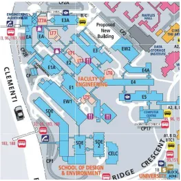
Fig 3: Campus Map (part) of National University Singapore
NUS Engineering Faculty was chosen as the venue of the first 3 trials of “experiment” (see Fig 3), where even staffs and students complained about the problems of disorientation. The wayfinding tasks required 10-20 minutes for participants to reach the destination and usually needed to cross 3-5 buildings, which would “flatten” the user tracks, i.e. the routes participants taken were rarely overlapped when they were mapped onto 2D surface. As a result, participants may feel like themselves walking on the surface of uneven terrain, rather than inside a 3D architectural space. The problems about vertical wayfinding identified by Soeda and his colleagues (1997) were thus
“softened” in these 3 trials, though the elevators may seem still to cause some troubles.
Pilot studies also suggested that including encoded verbalization, especially the 3rd level verbalization, might make participants rationalize their wayfinding
decision- making process, rather than simply externalizing their real thought process.
In addition, one purpose of the first round of pilot studies is to identify different patterns of outdoor and indoor wayfinding; however, few differences
Fig 4: the semi-open type of pedestrian circulation system in tropic buildings Due to tropic climate where the rainy season can last for months, the buildings are often interconnected by pedestrian corridors and annexes as shown in stick-like shapes in Fig 3. Thus the wayfinding procedure in such settings could violate the classical “coarse-to-fine” hierarchical wayfinding procedure (Calori, 2007, p.87), which was generalized from the studies in Canada and Northern Europe. When the uneven terrain is taken into consideration, the situation becomes much more complex. One example, the 3rd storey of Block
E1A is almost seamlessly connected to the 6th storey of Block E1. As a result,
people usually do not feel the transition if they do not pay specific attention to it. It implies that, just like hyperlinks enable web surfers enter the specific
webpage without logging in the homepage, people may make the similar shortcuts in Singaporean buildings. A more flexible wayfinding structure is thus needed for designing wayfinding aiding artefacts in such a context.
Finally, some participants’ behaviours observed in pilot studies seemed to be improvised or irrational and cannot be well explained by the logic and
propositional wayfinding theory championed by Passini (1984a, b, 2002; Arthur & Passini, 1992).
2.1.2 The Second Round of Pilot Studies
Based on the findings of the first round of pilot studies, a more appropriate place, School of Design and Environment (SDE) as shown in Fig 3 was chosen for further studies, as the pedestrians’ tracks are overlapped in the bird’s eye view, and the role of vertical travelling can therefore be emphasised.
A real-time vision simulation was proposed to complement the shortcomings of wayfinding protocols identified from the pilot studies, i.e. not well explain
District
Building Complex
Specific Wing
Floor
Room (destination)
some irrational behaviour. It is also due to the use of the 3rd level of
[image:10.595.252.390.209.369.2]verbalization which possibly violates the normal thought process. A new version of verbalization instruction was adopted and required participants to “talk aloud” as much as possible and not try to explain their thought and actions. The simulated vision is not only supposed to compromise the seeming loss of new verbal protocols; this modification can also provide additional visual information which is crucial in spatial problem solving (Arthur & Passini, 1992; Garling, Book, & Lindberg, 1986; Passini, 1984b; Weisman, 1981).
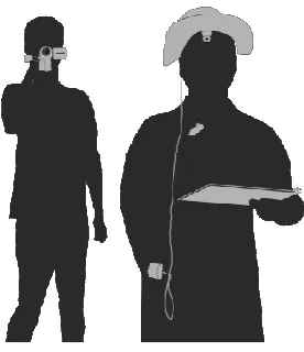
Fig 6 shows the setup of vision simulation. Participant wore a special hat, where a forehead-positioned mini camera is installed, during the wayfinding “experiments”. The mini camera can always be close to participants’ eyes and can be rotated with their head movement. Meanwhile, an experimenter with a handheld DV camera follows about 2 meters behind the participant. This video does not only capture the observed wayfinding behaviours, but also serve as references in order to provide better understanding of the simulated vision.
A more rigorous classification method of pedestrian circulation system, i.e. to distinguish the semi-open type of indoor space with closed one, is proposed for the study. While excluding the outdoor task, distinguishing between the wayfinding behaviours in the settings with or without visual access to external references was specially recorded.
Another 3 trials in the second round of pilot “experiments” were conducted subsequently to refine the research methods and “experiment” procedures.
2.2 Research Methods for Quasi-Experiment
This quasi-experiment is an exploratory field study with an attempt to identify pedestrian behaviour related to wayfinding within general-purpose multi-storey buildings.
The participants were encouraged to behave just as they normally do, either gathering information from surroundings, in-place maps/signage, or seeking help from passers-by.
artefacts that can support pedestrian wayfinding in general-purpose 3D spaces.
2.2.1 Physical Settings of Quasi-Experiment
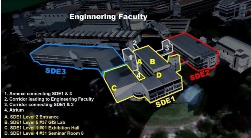
[image:11.595.119.532.200.427.2]The venue of the final experiment was in SDE1 block, a five-storey building as shown in Fig 7. However, in some cases, when participants took convenient routes, they may go through the annexed building between SDE1 and SDE3 (item1 in Fig 7) and part of SDE3 block.
Fig 7 Settings of this wayfinding study
(Acknowledge: the background picture is acquired from NUS Interactive Media Lab)
The floor layouts of each storey are not identical. Due to the uneven terrain, Exhibition Hall (C in Fig 7) is the only 1st floor of SDE1 and only the tower-like
stairwell (around B in Fig 7) contains the 5th storey.
There are two sets of relatively independent pedestrian circulation systems in SDE1: one is in that tower-like stairwell, which is closed space with high
restrained visual access (i.e. people cannot see external surroundings and only can see a fragment of internal settings at any single vantage point) and the other is semi-open space – due to the atrium (4 in Fig 7) -- with at least one side of wide visual access to external landmarks where people could get a relatively comprehensive overview of the whole setting and may partially rely on outdoor wayfinding tactics.
2.2.2 Vision-Simulation-Augmented Wayfinding Protocol
Both types of verbal protocols, i.e. concurrent verbalization and retrospective verbalization, were adopted to enhance the validity of self-reported data. The concurrent protocol is gathered by a mini audio recorder pinned on
participants’ collar as shown in Fig 6.
need to describe some architectural elements, they were encouraged to point at the reference instead of speaking out. These pointing actions were recorded by DV. The multi-modality recording method was applied to materialise participants’ thoughts process easily. This kind of integration was also championed by Ericsson and Simon (1993) who argued that protocol analysis should complement with visual data.
The simulated real-time vision is the complementary data source to the wayfinding protocols. It is vital to understand the wayfinding process in a meaningful way as the verbal protocols directly gained from participants were often incomplete and, sometimes, fragmented. In addition, the DV camera can also capture the unconscious behaviour not been aware of by participants.
2.2.3 Participants
14 participants3took part in this experiment. 7 were frequent visitors (4 female and 3 male) who have studied in SDE complex for at least 6 months, and the others (3 female and 4 male) were newcomers who have never visited SDE before the “experiment”. All participants were volunteers recruited from campus intranet, and no reimbursement was paid for their participations. When the participants registered for the experiment, they were required to fill a questionnaire which will reflect basic demographic information and also the participants’ self-analysis of their spatial ability; the later information is gained via a compact version of SBSOD (“Santa Babara Sense of Direction Scale”; Hegarty, Richardson, Montello, Lovelace, & Subbiah 2002).
2.2.4 Procedures of Quasi-Experiment
The whole quasi-experiment was comprised of three sessions: training, wayfinding tasks and post-test interviews.
In the training session, each participant would be taught how to “think aloud” through a poker game. The warm-up exercise lasted about 5 minutes.
The main body of this “experiment” was to complete 3 independent wayfinding tasks emphasizing on different environmental influences with vision-simulation-augmented wayfinding protocol. The first task was to walk from A to B (see Fig 7), which participants were always in closed space. The second one was from B to C, in which the convenient route needs to go through annexe 1 and part of SDE3. The third task was from C to D; when arrived D, they were further requested to go back to the B, the destination of the first task.
All three tasks involved storey vertical travelling and may involve inter-building travelling. The last task, especially its second part, was designed to investigate the transition between the two types of circulation systems. When completing one task, the participant was then asked to describe how s/he completed the task in a temporal sequence. In the same time, s/he was encouraged to draw a schematic map-like sketch to aid their retrospective
description. Participant may be requested to explain some “irrational” actions or clarify some verbalizations in the end.
2.2.5 Data Gained from Quasi-experiment
A set of verbal and visual data was recorded, including: wayfinding
[image:13.595.120.391.212.340.2]performance directly observed, real-time vision simulation, concurrent and retrospective wayfinding protocols, freehand drawing schematic maps, and participants’ demographic information, self-reported sense of direction and other comments about their daily wayfinding experience.
Fig 8: A snapshot of multimedia file for analysis
The small picture in top right corner is the real-time vision simulation
All video and audio data for each task were synchronized into one single file for further analysis (see Fig 8). Both current and retrospective protocols were transcribed into text form. Schematic sketch and other information were also classified.
3. Findings and Discussion
3.1 General Wayfinding Performance
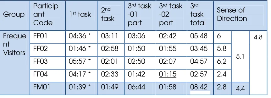
[image:13.595.121.552.613.770.2]Table 2 shows the performance time for each wayfinding task, as well as the self-reported grade of sense of direction (SOD). For the overall performance, the frequent visitors did not show significant advantage over the newcomers. This may partially due to the difference of SOD; in our experiment, newcomers were more confident with their wayfinding capability, their self-reported SOD grades are superior to frequent visitors’.
Table 2: Performance time for each subtask and the self-reported sense of direction
Group
Particip ant Code
1st task 2nd
task
3rd task
-01 part
3rd task
-02 part
3rd
task total
Sense of Direction
FF01 04:36 * 03:11 03:06 02:42 05:48 6 FF02 01:46 * 02:58 01:50 01:55 03:45 5.8 FF03 05:57 * 02:01 02:50 02:07 04:57 6.2 FF04 04:17 * 02:33 01:42 01:15 02:57 2.4
5.1
Freque nt Visitors
*
FM02 03:02 * 02:45 01:44 02:47 04:31 3.6 FM03 06:28 * 02:29 03:36 02:31 06:07 6.8 NF01 01:35 05:21 03:48 06:47 10:35 3 NF02 01:52 09:27 03:15 02:41 05:56 2 NF03 02:31 * 03:11 04:10 01:08 05:18 2.2
2.4
NM01 02:37 06:12 02:36 06:48 09:24 3.6 NM02 04:05 * 04:56 05:51* 01:47 07:38 5 NM03 01:14 02:35 05:58 01:33 07:31 2.4
New Comer
s
NM04 03:18 * 03:12 06:02 01:32 07:34 5.4 4.1
3.4
1. Code example: FM02 = No.2 Male participant in “Frequent visitor” group; NF03 = No.3 Female participant in “Newcomer” group;
2. For Sense of Direction (SOD), 1= excellent, 7= extremely poor;
3. * means participant referred to map in that subtask;
4. The underline means their strategy in that task were significantly different from others in the same group.
However, for the well known places, such as exhibition hall in the 2nd task (C in
Fig 7), the frequent visitors indeed performed significantly better than the newcomers. The average time for frequent visitors is almost half of
newcomers’ (2:32 vs 4:59).
The frequent visitors seemed not to show exploratory spirits in their frequent visited buildings. In the second part of the third task, for example, most of frequent visitors inclined to detour to their familiar areas, which are partially overlapped with the surrounding of the first task; while most of newcomers tried to explore the place they have never been to and found a novel and favourable route. Therefore, newcomers outperformed the frequent visitors in the score of 1:44 vs. 2:204
.
3.2 Analytic Framework for Qualitative Analysis
In our review of Passini’s studies, his description on wayfinding process could be challenged as it was excessively focused on human’s perceptual and cognition process, and containing a strong overtone of cognitivist theories. However, cognitivist theorist often assumed an overly simplistic view of human beings as “information- processing” machines (Bødker, 1991), which
emphasizes logical reasoning and inference, but ignoring the bodily capabilities and pre-conceptual and non-propositional aspects of mind (Johnson, 1987). As counter-reactions to cognitivist theories, post-cognitivist theorists, such as Suchman (1987, 2007), Nardi (1996), Kaptelinin and
Nardi,(2006), treat human activity not as a rationalistic and well-planned
[image:14.595.119.548.81.298.2]process, but as a process characterized by “arationality and action in situations” (Suchman, 1987). Our empirical findings also echo such a perspective.
3.2.1 Consciousness and Action
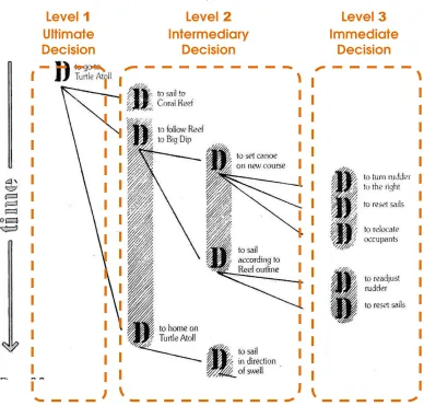
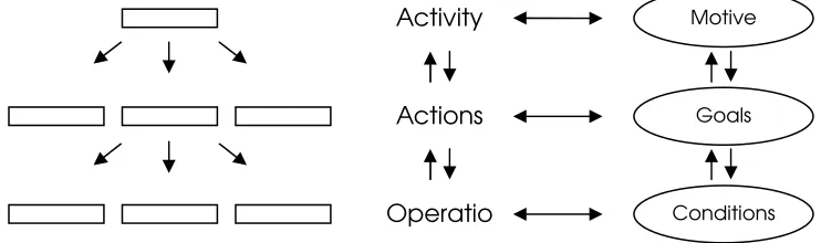
In the study, the analytic framework embraced not only the activity theory, but ethnomethodology which argues the locus of inquiry should be the “a very fine-grained level of minutely observed activities” (Suchman, 1987). According to activity theory, activity, including wayfinding activities, is “a subset of all possible processes related to the interaction of the subject with the world” (Kaptelinin & Nardi, 2006). Each activity, can be represented as a three-layered hierarchical structure as shown in Fig 8 (Gay & Hembrooke, 2004; Kaptelinin & Nardi, 2006; Kuutti, 1996).
This 3-level hierarchical structure should be distinguished from Passini’s classical wayfinding model (see Fig 2) though their representations are quite similar as both can be composed of a sequence of steps.
In contrast to Passini’s rigid model where sufficient information contributes to decision-makings which lead to behaviours, the activity theory’s structure is dynamic in nature. There are no firm borders between actions and operations or between activity and actions. It is easy to understand that wayfinding activity could be one action of other higher level activity, thus mutual
transformation between levels of action and of operation was emphasized in this paper.
In activity theory, operations, the lower-level units, are “routine processes providing an adjustment of an action to the ongoing situation” (Kaptelinin & Nardi, 2006). People are typically not aware of operations. Those operations are not simply motor behaviours in Passini’s description; but are
“improvisations” in reaction to current situation or “automatisation of actions”. In other words, consciousness is one of the main distinguishing criteria for these two levels. Shifting the focus of attention often concurs with action-operation dynamics.
For example, newcomers deliberately thought for a while before deciding if they could go into the closed pedestrian circulation system from the semi-Fig 9 Hierarchical structure of activity
Adapted from Kapteline & Nardi (2006) and Kuutti (1996) Activity
Operatio Actions
Motive
[image:15.595.128.499.288.398.2]open one via a glass door; they were in action level. However, experience made frequent visitors go through that door without hesitation. This was not because frequent visitors remembered the previous decisions as Passini (1984b) claimed; actually, they may not have even explicitly acknowledged the
existence of that door. Their actions had been “automatised” into
unconscious operations which could be directly triggered by the situation. However, when the situation changes, like if the door is locked; they will turn their operation into conscious action again to check what happens.
3.3 Summary of Tentative Findings
Due to the massive amount of data, the followings demonstrate only some tentative findings identified:
(1) The study demonstrated that most decisions reported by participants were rough and tactic-like, while the immediate decisions, i.e. those directly lead to behaviours (Passini, 1984b), were rarely mentioned. One observation was that it may be due to people’s bodily capability in pre-conceptual and
non-propositional structure rather than rigid cognitive capability that fulfills the gap between intermediary propositional decisions and actual behaviours.
Moreover, people, both frequent visors and newcomers, seemed to directly “make sense” of the settings, without detailed logical reasoning.
(2) Recurring behaviours could degrade some episodes of wayfinding process into operations which could be directly triggered by situation. Even the
newcomers would perform some operations learnt from experience in other settings. This could explain why many newcomers can find their ways fairly well when they visit some building complexes they have never been to. This may also imply that current wayfinding support devices give route instructions that are too detailed and not required by users.
However, with familiarity of the current setting, frequent visitors are more likely to “automatise” conscious actions into unconscious operations than
newcomers, thus they usually outperform over the latter. But counter-effects also occurred. For example, frequent visitors refer to their habitual behaviours and the known terrain more than that of newcomers, thus lack the exploratory nature.
(3) Both newcomers and frequent visitors seemed to apply the “floor strategy”, i.e. find the way to the floor of the destination first (Hölscher et al., 2005), and with a “search strategy” of increasing or decreasing room numbers when they arrive at a particular floor. It should be noted that, the particular storey may not be restricted to a single building block, it can be referred to a certain horizontal plane across several interconnecting buildings instead.
point. Rather than additive way of “cognitive map” formulation in the former type, the mental representation of the latter one is more like a collage of fragments, containing more distortion and errors.
However, inferior sense of orientation seemed not to be equal to actual wayfinding performance. In the second type of inter-storey travelling, for example, people tend to segment the whole process into several relatively independent subtasks using staircases as division lines.
(5) Some people have problems with map reading (Ottosson, 1987). The storey layout map seems more challenging than normal street maps. An intuitive way to depict pedestrian circulation systems for indoor wayfinding purpose is therefore required.
(6) Social solutions to wayfinding problems are one of the means that people relied on in their daily lives. However, little design solutions echo in this
perspective.
3.4 Discussions
Generally, the new analytic framework enables different, but also reasonable, interpretations about pedestrian’s wayfinding performance in 3D structure. Researchers involved in wayfinding studies would also benefit from the alternative approach to gather richer data about wayfinding activity than that of Passini. Episodes of multimedia records of wayfinding performance, rather than rigid and concise textual description, can be reviewed and interpreted in many different ways. Since design ideas are easy to be triggered from exposing to potential solutions and use situations (Löwgren & Stolterman, 2005), those detailed contextual information can serve as a cognitive tool to provoke discussion, and even inspire new insights, among designers when developing wayfinding assisting devices.
Like most of other techniques which investigate people’s inner thoughts, this method also contains the risks of altering people’s normal behaviours for concurrent verbalization and being distorted by faulty memory and post-rationalization for retrospective verbalization. People who adapted this method should be aware of these limitations. However, the combination of visual data and both concurrent and retrospective protocols could enhance the validity of self-reported data.
4. Conclusions and Further Studies
This study departs from examining Passini’s seminal wayfinding studies and other studies emphasizing on wayfinding in architecture. Through questioning both Passini’s version of wayfinding protocol and the underlying wayfinding theory based on decision-making process, a new wayfinding research method and a new analytic framework in order to remedy the shortcomings of Passini’s studies were proposed, i.e. a vision-simulation-augmented
In addition, studies in representations of “cognitive maps” are also
recommended. For example, route-like and topological representations seem to be two poles of cognitive maps representation continuum, the exact
position in this continuum may be correlated to some certain wayfinding factors. The association between representation type and the familiarity with settings may contribute to the information design of new wayfinding
supporting artefacts.
References
Arthur, P., & Passini, R. (1992). Wayfinding: people, signs, and architecture. New York: McGraw-Hill.
Bødker, S. (1991). Through the interface: a human activity approach to user interface design. Hillsdale, N.J.: L. Erlbaum.
Calori, C. (2007). Signage and wayfinding design: a complete guide to
creating environmental graphic design systems. Hoboken, N.J.: John Wiley.
Carpman, J. R., & Grant, M. A. (1993). Design that cares: planning health
facilities for patients and visitors (2nd ed.). Chicago, Ill.: American Hospital Pub. Carpman, J. R., & Grant, M. A. (2001). Wayfinding: a broad view. In R. B.
Bechtel & A. Ts'erts'man (Eds.), Handbook of environmental psychology (pp. 427-442). New York: J. Wiley.
Carpman, J. R., Grant, M. A., & Simmons, D. A. (1985). Hospital Design and Wayfinding: A Video Simulation Study. Environment and Behavior, 17(3), 296. Cross, N., Christiaans, H., & Dorst, K. (1996). Analysing design activity.
Chichester: : Wiley.
Ericsson, K. A., & Simon, H. A. (1993). Protocol analysis : verbal reports as data (Rev. ed.). Cambridge, Mass.: MIT Press.
Garling, T., Book, A., & Lindberg, E. (1986). Spatial Orientation and Wayfinding in the Designed Environment - a conceptual analysis and some suggestion for postoccupancy evaluation. Journal of Architectural and Planning Research, 3(1), 55-64.
Gay, G., & Hembrooke, H. (2004). Activity-centered design: an ecological
approach to designing smart tools and usable systems. Cambridge, Mass.: MIT
Press.
Hölscher, C., Meilinger, T., Vrachliotis, G., Brosamle, M., & Knauff, M. (2004). Finding the way inside: Linking architectural design analysis and cognitive processes. In Spatial Cognition Iv, Reasoning, Action, Interaction (Vol. 3343, pp. 1-23). Berlin: Springer-Verlag Berlin.
Hölscher, C., Mellinger, T., Vrachliotis, G., Brosamle, M., & Knauff, M. (2006). Up the down staircase: Wayfinding strategies in multi-level buildings. Journal of
Environmental Psychology, 26(4), 284-299.
Hölscher, C., Vrachliotis, G., & Meilinger, T. (2005). The Floor Strategy:
Hegarty, M., Richardson, A. E., Montello, D. R., Lovelace, K. & Subbiah, I. (2002). Development of a self-report measure of environmental spatial ability.
Intelligence 30(5), 425-447.
ICSID. (2001). 2001 Seoul Industrial Designer's Declaration. Retrieved March 25, 2007, from
http://icsid2001.designdb.com/english/l_congresse/declaration2001.html Johnson, M. (1987). The body in the mind : the bodily basis of meaning,
imagination, and reason. Chicago: University of Chicago Press.
Kaptelinin, V., & Nardi, B. A. (2006). Acting with technology : activity theory
and interaction design. Cambridge, Mass.: MIT Press.
Kuutti, K. (1996). Activity Theory as a Potential Framework for Human-Computer Interaction Research. In B. A. Nardi (Ed.), Context and
consciousness : activity theory and human-computer interaction (pp. 17-44).
Cambridge, Mass.: MIT Press.
Löwgren, J., & Stolterman, E. (2005). Thoughtful interaction design: a design perspective on information technology. Cambridge, Mass.: MIT Press. Nardi, B. A. (Ed.). (1996). Context and consciousness: activity theory and
human-computer interaction. Cambridge, Mass.: MIT Press.
Ottosson, T. (1987). Map-reading and wayfinding. Goteborg, Sweden: Acta Universitatis Gothoburgensis.
Passini, R. (1984a). Spatial representations, a wayfinding perspective. Journal of Environmental Psychology, 4(2), 153-164.
Passini, R. (1984b). Wayfinding in architecture. New York: Van Nostrand Reinhold.
Passini, R. (2002). Wayfinding research and design: an interdisciplinary
approach in the development of design knowledge and its application. In J. Frascara (Ed.), Design and the Social Sciences: Making Connections (pp. pp. 96-101): Taylor & Francis.
Raubal, M., & Egenhofer, M. (1998). Comparing the complexity of wayfinding tasks in built environments. Environment & Planning B, 25(6), 895-913.
Raubal, M., Egenhofer, M., Pfoser, D., & Tryfona, N. (1997). Structuring space with image schemata: Wayfinding in airports as a case study. In Spatial Information Theory A Theoretical Basis for GIS (pp. 85-102).
Raubal, M., & Worboys, M. (1999). A Formal Model of the Process of
Wayfinding in Built Environments. In Spatial Information Theory. Cognitive and Computational Foundations of Geographic Information Science: International
Conference COSIT'99, Stade, Germany, August 1999. Proceedings (pp.
748-748).
Soeda, M., Kushiyama, N., & Ohno, R. (Eds.). (1997). Wayfinding in Cases with Vertical Motion.
Suchman, L. A. (1987). Plans and situated actions : the problem of
human-machine communication. Cambridge [Cambridgeshire] ; New York:
Suchman, L. A. (2007). Human-machine reconfigurations : plans and situated
actions (2nd ed.). Cambridge ; New York: Cambridge University Press.
Weisman, J. (1981). Evaluating Architectural Legibility: Way-Finding in the Built Environment. Environment and Behavior, 13(2), 189.
Jiang Hao
Jiang is a PhD student in Department of Architecture, National University of Singapore (NUS). He has received his Bachelor and Master degrees from Department of Industrial Design in Zhejiang University, China. He is currently focusing on, under the discipline of interaction design, applying the “on-the-move” technologies into the design and development of wayfinding assisting artefacts for pedestrian.
Yen Ching Chiuan (Dr.)
Dr. Yen Ching Chiuan is an Assistant Professor in the Department of