Open Access
Methodology
Accuracy of city postal code coordinates as a proxy for location of
residence
C Jennifer D Bow
2,4, Nigel M Waters
2,4, Peter D Faris
4, Judy E Seidel
3,4, P
Diane Galbraith
4, Merril L Knudtson
1,4, William A Ghali*
1,3,4and the
APPROACH Investigators
Address: 1Department of Medicine, University of Calgary, 3330 Hospital Drive NW, Calgary, AB, T2N 4N1, Canada, 2Department of Geography,
University of Calgary, 2500 University Drive NW, Calgary, AB, T2N 1N4, Canada, 3Department of Community Health Sciences, University of
Calgary, 3330 Hospital Drive NW, Calgary, AB, T2N 4N1, Canada and 4Centre for Health and Policy Studies, Faculty of Medicine, Department of
Community Health Sciences, University of Calgary, 3330 Hospital Drive NW, Calgary, AB, T2N 4N1, Canada
Email: C Jennifer D Bow - [email protected]; Nigel M Waters - [email protected]; Peter D Faris - [email protected]; Judy E Seidel - [email protected]; P Diane Galbraith - [email protected]; Merril L Knudtson - [email protected]; William A Ghali* [email protected]; the APPROACH Investigators
-* Corresponding author
Geographic LocationPostal CodeGIS (Geographical Information Systems)
Abstract
Background: Health studies sometimes rely on postal code location as a proxy for the location of residence. This study compares the postal code location to that of the street address using a database from the Alberta Provincial Project for Outcome Assessment in Coronary Heart Disease (APPROACH©). Cardiac catheterization cases in an urban Canadian City were used for calendar
year 1999. We determined location in meters for both the address (using the City of Calgary Street Network File in ArcView 3.2) and postal code location (using Statistic Canada's Postal Code Conversion File).
Results: The distance between the two estimates of location for each case were measured and it was found that 87.9% of the postal code locations were within 200 meters of the true address location (straight line distances) and 96.5% were within 500 meters of the address location (straight line distances).
Conclusions: We conclude that postal code locations are a reasonably accurate proxy for address location. However, there may be research questions for which a more accurate description of location is required.
Background
Postal codes are often used in health research to define geographical location of residence either directly or via linkages to census geographical units [1-11]. The fields of epidemiology and medical geography both examine
research questions where analysis of location of residence is either desirable or required. Examples of types of spatial analysis requiring exact location of residence include loca-tion allocaloca-tion, cluster analysis, and point-pattern analy-sis. These analysis methods are often applied when
Published: 18 March 2004
International Journal of Health Geographics 2004, 3:5
Received: 01 December 2003 Accepted: 18 March 2004
This article is available from: http://www.ij-healthgeographics.com/content/3/1/5
searching for geographical clusters of disease or geograph-ical patterns of health service utilization.
Despite its widespread use in health research, the validity of the postal code for location of residence is not known. Two previous studies have addressed methodological issues regarding the use of postal code to define location in medical studies. Burra, Jerrett, et al. [12] identified error associated with postal code location and attributed some of this error to inaccuracies in the Statistics Canada postal code conversion file [13]. Glass, Gray, et al [14] assessed the validity of cancer registry data in Scotland noting a 44 percent error rate in the database including errors relating to the input of the postal code, which led to an error in their cluster analysis. While useful, the above two studies alone do not provide a clear indication of how valid loca-tion derived from postal codes is relative to localoca-tion derived from street addresses.
The Alberta Provincial Project for Outcome Assessment in Coronary Heart Disease (APPROACH©) is a large,
popula-tion-based, clinical registry that captures all patients undergoing catheterization and subsequent revasculariza-tion in Alberta, Canada [15]. The registry has been used to study outcomes and processes of care relating to cardio-vascular disease and has recently been applied to an anal-ysis of geographical location of residence as a predictor of cardiac care [16]. The APPROACH clinical registry con-tains both street address and postal code for each patient and provides an opportunity to assess the accuracy of postal code location as a proxy for residence location.
Accordingly, the objective of this methodological study was to determine the accuracy of postal code location compared to address location in the urban setting of a large Canadian City. We confined the analysis to urban locations because it is in urban locations that the postal code is likely to be most accurate and problems exist with postal code misclassification in rural areas. Precise geo-graphical coordinates for street address locations were derived using a detailed street network file and were com-pared to the geographic coordinates derived for the postal code from the Statistics Canada Postal Code Conversion File.
Methods
Data sources
The APPROACH database is a clinical data collection ini-tiative that began in 1995 that includes all patients under-going cardiac catheterization in the province of Alberta, Canada. For this study the most important characteristics of the database were the patient's unique identifier, the address, and the postal code. The data for this study were confined to residents of the City of Calgary undergoing cardiac catheterization in the calendar year 1999.
The Canadian Postal Code is 6 characters long with alter-nating alphabetic and numeric characters of 'ANA NAN'. The first three characters identify a major urban or rural area known as the 'forward sortation area' and the last three characters identify the smallest delivery unit – the 'local delivery unit' [17]. The 'local delivery unit' may indi-cate a specific city block, a single building, or a large vol-ume mail receiver [17].
The Postal Code Conversion File, created by Statistics Canada and Canada Post, contains information on each postal code in Canada. The Postal Code Conversion File provided the geographic coordinates of each postal code in latitude and longitude. Within major urban areas, postal code address ranges are linked to the National Geo-graphic Base, and where possible, a block-face link and its coordinates are identified. Municipality maps and direct contact with local authorities are then used to derive pre-cise locations for postal codes relative to these block face links [13].
The City of Calgary Street Network File, created by the City of Calgary, contains street information for the city, as recorded in 2001. The Street Network File permitted us to determine the geographic coordinates of each address recorded in the APPROACH database through interpola-tion of individual home addresses on a range of addresses represented by a street (see section on Determining Loca-tion below).
Study sample
mismatch errors. The major reasons for these discrepan-cies were: postal code and address did not match, missing or incomplete address, address did not exist, wrong street name or number, consequential spelling error, or the postal code was recorded with one or more errors in its let-ters or digits (errors that presumably arise from the com-plexity of manually keying in postal codes and street addresses). Of the 481 mismatch errors detected in the database, 268 records were corrected and the remaining 213 uncorrected cases had to be excluded from further analysis. An additional 7 cases were removed during postal code conversion. Subsequent analysis focused on the remaining 2727 records with complete and accurate information on both the address and postal code.
Determining location
The address location was determined spatially by a proc-ess in a Geographical Information System (GIS) known as geocoding. Because each Street Network File contains information for each arc or street, including address ranges, it is possible to compute where specific addresses would be hypothetically located on that arc or street. Arcs are divided into equal segments that permit individual address points to be estimated at an appropriate place on the street network. Geocoding was used in ArcView 3.2 GIS Software http://www.esri.com to determine the spa-tial location of each address in the APPROACH database. Of the 2727 addresses available, 2687 (98.5 percent) of the address locations were geocoded by ArcView. Addresses that did not geocode were likely due to missing address information in the City of Calgary street network file database or, less likely, may have represented a missed error in the APPROACH database. The address locations were then mapped and the location of the x and y coordi-nates were found to the nearest meter that correspond to the latitude and longitude of the North American Datum of 1927, Zone 11.
The postal code spatial location was determined by cross-referencing the postal code in the APPROACH database to the geographic coordinates found in Statistic Canada's Postal Code Conversion File. This cross-referencing was performed using Microsoft Access's http://www.micro soft.com query function. Once the postal code in the APPROACH database was matched to a geographic coor-dinate it was possible to map the location of each of the postal codes in ArcView 3.2. Only the 2687 matching pairs of the 2727 address points were used. These matched pairs were those for which a precise location could be determined based on street address, as described in the preceding paragraph. The postal code locations were found to the nearest meter that correspond to the lat-itude and longlat-itude of the North American Datum of 1927, Zone 11.
Data analysis
The address and postal code spatial locations were com-pared on a map to determine visually how closely the postal code represented the address. The distance between each of the address and postal code location pairs was then determined. The x (east-west) and y (north-south) dimensions of the differences between paired points was computed for each pair of points and a scattergram of these differences was created in the Statistical Package for the Social Sciences (SPSS, http://www.spss.com). Straight-line (Euclidean) distances were calculated using the for-mula z = √ ((xi - xj)2 + (yi - yj)2), and city-block
(Manhat-tan) distances were calculated using the formula z = (xi -xj) + (yi - yj). The latter were studied because they approx-imate the true travel distance between any two given points in typical urban grids where buildings often pre-vent straight line travel. Descriptive statistics were com-puted for the Euclidean and Manhattan distances using SPSS.
Results
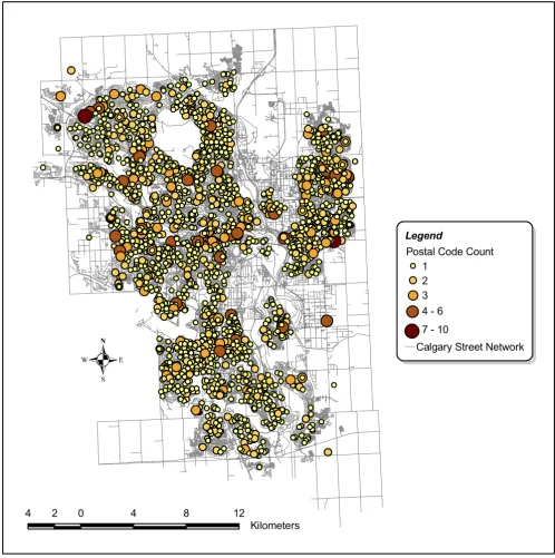
The postal code locations for the City of Calgary are dis-played spatially in Figure 1. Mapping the postal code loca-tion is a visual tool that can help in interpretaloca-tion of geographical relationships in health data, provided, of course, that the postal code location presented in Figure 1 is reasonably accurate. In Figure 1, the size of the marker representing each postal code is varied to indicate the number of study subjects (1 to 10) drawn from that postal code.
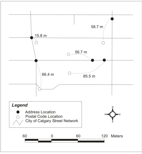
The address and the postal code locations for a represent-ative area of the City of Calgary is shown in Figure 2. In this figure, one can see how the distances between the address and postal code locations can vary across pairs. The range of location differences in this example of a small downtown area is between 15.8 meters and 85.5 meters. The range may be larger or smaller in other areas of the City depending on the road type and length, and on the size and shape of the postal code area in question.
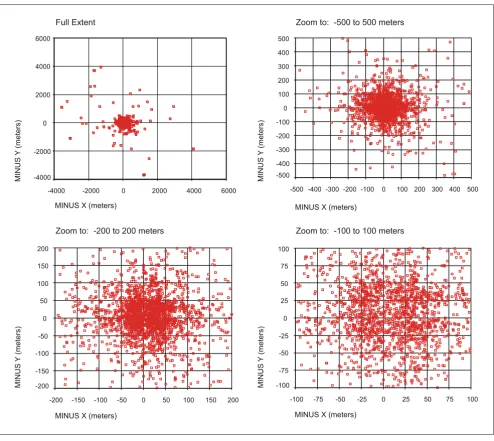
The x and the y-axis of the address and postal code loca-tion differences are plotted in Figure 3. Scattergrams are displayed in this figure at various scales. The full-extent plot displays a number of outliers where the spatial dis-tance between the address and the postal code can be more than 4000 meters. For the majority of data pairs however, the distance between the address and the postal code locations is less than 50 meters.
(straight-line) distance has a higher mean of 146.2, a greater range of values, and a higher standard deviation of 369.3. As expected, Manhattan distances were larger than the abso-lute x and y values and the Euclidean distance because Manhattan distance attempts to describe the restrictive movement of travel in typical urban centers, which use a rectangular grid pattern of streets. By assessing the 25th
percentile, the median, and the 75th percentile of the x
dis-tance, y disdis-tance, the Euclidean disdis-tance, and the Manhat-tan DisManhat-tance, and by comparing these values to the corresponding means and standard deviations shown in Table 1, it becomes apparent that the distributions of dis-tances is skewed, with a few observations demonstrating large distance differences.
City of Calgary postal code locations Figure 1
City of Calgary postal code locations
.
4 2 0 4 8 12
Kilometers
Legend
Postal Code Count 1
2 3 4 - 6
7 - 10
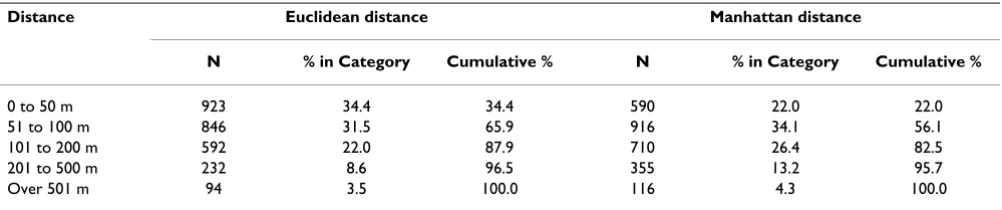
The proportion of patients falling into various distance difference categories is shown in Table 2. For Euclidean distance, 34.4 percent of the postal code locations are
within 50 meters of the address location, 65.8 percent are within 100 meters, and 96.5 percent are within 500 meters. To place these values in perspective, if one city
Example of a small area in the City of Calgary indicating address and postal code locations Figure 2
Example of a small area in the City of Calgary indicating address and postal code locations
Address Location
Postal Code Location
City of Calgary Street Network
60 0 60 120 Meters
Legend
15.8 m
66.4 m
56.7 m
58.7 m
85.5 m
S N
Scattergrams of the City of Calgary x and y distances from the full extent to zoomed in versions at 500, 200, and 100 meters Figure 3
Scattergrams of the City of Calgary x and y distances from the full extent to zoomed in versions at 500, 200, and 100 meters
Table 1: Descriptive statistics of distance difference between pairs of addresses and postal codes (meters)
Statistic X distance Y distance Euclidean distance Manhattan distance
Range 4092.1 3928.7 4480.9 5919.4
Minimum .02 .01 1.51 2.05
Maximum 4092.09 3928.66 4482.38 5921.45
25th Percentile 20.1 18.6 41.5 52.7
75th Percentile 85.6 81.6 128.2 158.3
Median 38.4 38.3 69.1 87.2
Mean 95.7 89.9 146.2 185.6
Standard Deviation 271.1 259.0 369.3 474.6
200 150 100 50 0 -50 -100 -150 -200 200
150
100
50
0
-50
-100
-150
-200
MINUS X (meters)
MINUS Y
(meters)
Zoom to: -200 to 200 meters
100 75 50 25 0 -25 -50 -75 -100 100
75
50
25
0
-25
-50
-75
-100
MINUS X (meters)
MINUS
Y
(meters)
Zoom to: -100 to 100 meters
MINUS X (meters)
500 400 300 200 100 0 -100 -200 -300 -400 -500 500
400
300
200
100
0
-100
-200
-300
-400 -500
Zoom to: -500 to 500 meters
M
INUS
Y
(meters)
MINUS X (meters)
Full Extent
MI
NUS Y
(m
et
ers)
6000 4000
2000 0
-2000 -4000
6000
4000
2000
0
-2000
block is approximately 200 meters, then 87.9 percent of the postal code locations are within one typical city block of the address location for straight-line distances. For Manhattan distance, 22.0 percent of the postal code loca-tions are within 50 meters of the address location, 56.1 percent are within 100 meters, and 95.7 percent are within 500 meters. Accordingly, 82.5 percent of the postal code locations are within one typical city block of the address location for Manhattan distances.
Conclusions
Using the postal code and address information from the APPROACH database, we were able to determine the spa-tial location of the street address and postal code and the difference in distance between those paired points. The major finding of the present study is that the postal code location closely approximates the location of residence for a large majority of patients with over 80 percent of the postal codes being within 200 meters of the address, and approximately 95 percent of the postal codes being with 500 meters of the street address.
How close is close enough for studies in epidemiology and medical geography? The answer to this question depends on the amount of accuracy needed to answer a specific research question, which in turn depends on the nature of the research question itself. For example, inves-tigation of a regional outbreak of E. coli gastrointestinal disease would probably not be hampered by a random misclassification of locations of 200 meters or less for the majority of cases. In contrast, the planning of fire station or emergency medical service (EMS) networks within city limits is an example of a scenario where the accuracy of postal code locations demonstrated in our study may not suffice. Indeed, dealing with only approximately 80 per-cent accuracy rates for placing residences within a city block might lead to problems if one were to rely on postal codes only in the planning of locations for EMS and fire stations. The consequence of using postal codes would potentially include misclassification of events and eventu-ally sub-optimal response times and access to service.
Accordingly, researchers and policy makers need to con-sider carefully the geographical issue that they are study-ing and should use postal codes only if an approximate localization of individuals will suffice. For our research on localization of patients undergoing cardiac catheterization to assess overall geographic equity and access within the City of Calgary, we conclude that the spatial relationships derived from postal codes (and pre-sented in Figure 1) represent a reasonable proxy for the true location of the residence. We are certain, however, that there are geographical scenarios for which more accu-rate determinations of location are required.
While a large majority of postal code locations were within 500 meters of true location of residence, it is nota-ble that some postal code locations were large distances from the actual street address location (up to 4,482 straight-line distance meters away). The reasons for these highly discrepant cases are unclear, but could include errors in the postal code conversion file geographical coordinates (something that has been anecdotally reported by researchers who work with this file [1,2], and [12]), errors in the geocoding process in ArcView 3.2 for the street address, or a missed error in the cleaning process of the APPROACH database. Of course, it is possible that some of these larger differences represent true differences between street address and postal code locations.
The major limitation of the present study is that it focuses only on a single large urban Canadian city. Accordingly, the results do not necessarily apply to other Canadian cit-ies or to citcit-ies in other countrcit-ies. However, there are many reasons to suspect that the findings for the single city stud-ied apply to other Canadian cities, and perhaps also to urban settings in other countries. In contrast, however, the results are unlikely to apply to rural postal codes where single postal codes cover large geographic areas. It is thus clear that additional research is needed to address the locational accuracy of postal codes in other environments. A second caveat to our findings is that we consider address locations geocoded from street network files as the
'refer-Table 2: Distance differences between pairs of addresses and postal codes in specific ranges
Distance Euclidean distance Manhattan distance
N % in Category Cumulative % N % in Category Cumulative %
0 to 50 m 923 34.4 34.4 590 22.0 22.0
51 to 100 m 846 31.5 65.9 916 34.1 56.1
101 to 200 m 592 22.0 87.9 710 26.4 82.5
201 to 500 m 232 8.6 96.5 355 13.2 95.7
ence standard' against which postal code location is com-pared. Such address locations are, in fact, themselves merely an estimate of location that may or may not be entirely accurate. Of relevance in this regard, Bonner and colleagues [19] recently compared geocoded address loca-tions with true 'gold standard' location measures derived from Global Positioning System satellite receivers, and demonstrated slight discrepancies between the two. Another important caveat to our findings is that we made corrections to the discrepant address and postal code pair-ings whenever possible. The result of these corrections is likely to be an overall improvement in accuracy of loca-tion that would not otherwise occur if real addresses had not been available. This means that our findings from APPROACH may slightly overestimate the accuracy of postal code locations in 'typical' health databases. A final caveat (that may bias findings in the opposite direction) is that we relied on the Statistics Canada Postal Code Con-version File to determine the latitude and longitude of postal code locations. This is a widely used approach. However, anecdotal reports suggest that the latitude and longitude values in Statistics Canada data may be some-what erroneous due to a geographical projection problem in the Statistics Canada street network file. These projection problems may in turn adversely affect the accu-racy of postal code locations.
Despite these limitations and caveats, our study is inform-ative. Our findings indicate that, although postal code location is not a perfect representation of street address location, the estimate is very close for a majority of cases. Researchers and policymakers interested in conducting and interpreting results of epidemiological or geographi-cal studies need to consider carefully, on a case-by-case basis, whether a misplacement of 200 to 300 meters (or more) in spatial location is problematic to the objectives of their analysis. If the misplacement is not a major con-cern and given the random nature of that misplacement, the postal code can be used for analysis. In other instances, more precise information on address location should be obtained and used in analysis.
Authors' contributions
CJDB compiled data, analyzed data, and wrote paper; NMW provided oversight of geographic analysis and pro-vided comments on drafts of paper; PDF assisted with data compilation and provided comments on drafts of paper; JES provided input into interpretation and pro-vided comments on drafts of papers; PDG assisted with data compilation and provided comments on drafts of paper; MLK principal investigator of APPROACH who oversees entire initiative and approved paper for submis-sion; WAG supervised all aspects of this project and con-tributed to manuscript writing and editing.
Acknowledgements
The APPROACH initiative was initially funded in 1995 by a grant from W. Garfield Weston Foundation. The ongoing operation of the project has been made possible by contributions from the Province-Wide Services Committee of Alberta Health and Wellness, Merck Frosst Canada Inc., Monsanto Canada Inc. – Searle, Eli Lilly Canada Inc., Guidant Corporation, Boston Scientific Ltd, Hoffmann-La Roche Ltd, and Johnson & Johnson Inc – Cordis. We appreciate the assistance of the Calgary Health Region and the Capital Health Authority in supporting on-line data entry by cardiac catheterization laboratory personnel.
We appreciate the assistance of Dr. Michelle Graham and Dr. Brent Mitch-ell for comments and revision suggestions.
Dr. Ghali is supported by a Health Scholar Award from the Alberta Herit-age Foundation for Medical Research, Edmonton, Alberta, and by a Govern-ment of Canada Research Chair in Health Services Research.
References
1. Ng E, Wilkins R, Perras A: How Far Is It to the Nearest Hospi-tal? Calculating Distances Using the Statistics Canada Postal Code Conversion File.Health Rep 1993, 5:179-183.
2. Mackillop WJ, Zhang-Salomons J, Groome PA, Pazat L, Holowaty E:
Socioeconomic Status and Cancer Survival in Ontario.J Clin Oncol 1997, 15:1680-1689.
3. Spasoff RA, Gilkes DT: Up-to-date denominators: evaluation of taxation family for public health planning.Can J Public Health 1994, 85:413-417.
4. Demissie K, Hanley JA, Menzies D, Joseph L, Ernst P: Agreement in measuring socio-economic status: area-based versus individ-ual measures.Chronic Dis Can 2000, 21:1-7.
5. Prince MI, Chetwynd A, Diggle P, Jarner M, Metcalf JV, James OFW:
The geographical distribution of primary biliary cirrhosis in a well-defined cohort.Hepatology 2001, 34:1083-1088.
6. Cousens SN, Linsell L, Smith PG, Chandrakumar J, Wilesmith JW, Knight RSG, Zeidler M, Stewart G, Will RG: Geographical distri-bution of variant CJD in the UK (excluding Northern Ireland).Lancet 1999, 353:18-21.
7. O'Neill TW, Cooper C, Finn JD, Lunt M, Purdie D, Reid DM, Rowe R, Woolf AD, Wallace WA: Incidence of distal forearm fracture in British men and women.Osteoporos Int 2001, 12:555-558. 8. Guernsey JR, Dewar R, Weerasinghe S, Kirkland S, Veugelers PJ:
Inci-dence of cancer in Sydney and Cape Breton County, Nova Scotia 1979–1997.Can J Public Health 2000, 91:285-292.
9. Mitchell JD, Gibson HN, Gatrell A: Amyotrophic lateral sclerosis in Lancashire and South Cumbria, England, 1976–1986, A geographical study.Arch Neurol 1990, 47:875-880.
10. Smart RG, Adlaf EM, Walsh GW: Neighbourhood socio-eco-nomic factors in relation to student drug use and programs. J Child Adolesc Subst Abuse 1994, 31:37-46.
11. Harris JM, Cullinan P, McDonald JC: Occupational Distribution and Geographic Clustering of Deaths Certified to be Cryp-togenic Fibrosing Alveolitis in England and Wales.Chest 2001,
119:428-433.
12. Burra T, Jerrett M, Burnett RT, Anderson M: Conceptual and prac-tical issues in the detection of local disease clusters: a study of morality in Hamilton, Ontario.Can Geogr 2002, 46:160-171. 13. Statistics Canada: Statistics Canada Postal Code Conversion File
Septem-ber 2002 Postal Codes Reference GuideCatalogue 92F0153GIE: Ottawa, ON: Ministry of Industry; 2002.
14. Glass S, Gray M, Eden OB, Hann I: Scottish validation study of Cancer Registration data childhood leukemia 1968–1981. Leuk Res 1987, 11:881-885.
15. Ghali WA, Knudtson ML: Overview of the Alberta Provincial Project for Outcome Assessment in Coronary Heart Dis-ease. On behalf of the APPROACH investigators.Can J Cardiol 2000, 16:1225-1230.
16. Seidel JE, Ghali WA, Faris PD, Bow CJD, Waters NM, Graham MM et al.: Distance and access to cardiac revascularization. Can J Cardiol 2002, Suppl B:184B.
Publish with BioMed Central and every scientist can read your work free of charge "BioMed Central will be the most significant development for disseminating the results of biomedical researc h in our lifetime."
Sir Paul Nurse, Cancer Research UK
Your research papers will be:
available free of charge to the entire biomedical community
peer reviewed and published immediately upon acceptance
cited in PubMed and archived on PubMed Central
yours — you keep the copyright
Submit your manuscript here:
http://www.biomedcentral.com/info/publishing_adv.asp
BioMedcentral 18. Hurley SE, Saunders TM, Nivas R, Hertz A, Reynolds P: Post office
box addresses: a challenge for geographic information sys-tem-based studies.Epidemiology 2003, 14:386-391.