The Journal of Public Space 2018 | Vol. 3 n. 1
https://www.journalpublicspace.org
PORTFOLIO
Lebanon Cities’ Public Spaces
Maryam Nazzal, Samer Chinder
UN-Habitat Lebanon
maryam.nazzal@un.org | samer.chinder@un.org
Public spaces, particularly in disadvantaged communities, bring people together to transform those spaces into vital places that highlight local assets, encourage renewal and serve common needs. Further, public spaces constitute a fundamental element in contemporary urban regeneration strategies entailing the creation of a public culture that shape public space for social interaction and constructing a visual representation of the city. A public space is a place publicly owned or of public use, which is accessible and enjoyable by all for free and without a profit motive. There are different types of public spaces: 1) multi-use public spaces such as avenues, streets, squares, sidewalks;
2) public open spaces such as parks, gardens, public beaches and beaches;
3) public urban facilities including for example libraries, markets and sport facilities. In city planning, public spaces are designed to improve the overall visual character of the city, as well as invigorating economic activities and enhancing the functionality of the city. Furthermore, public spaces promote social connectivity and diversity, thus making neighborhoods more cohesive, lively, and ultimately more attractive to residents and investors alike.
In Lebanon, the social connections are undeniable and crucial. However, meeting places remain private such as houses, restaurants, malls, and beach resorts. This is mainly due to the shortage of public spaces in Lebanon resulting from lack of planning, regulations and awareness around the right to the city and the importance of public spaces. In main cities where land prices are so expensive, common practice has prioritized the use of land in real estate development, thus trumping other uses such as public and communal spaces.
In the late 1990s, Lebanon saw the emergence of malls, which have arguably acted as alternatives to public spaces. Malls, with their wealth of food courts, restaurants, cinemas, and play areas, have become the new downtown for a portion of the Lebanese population. They are also considered safe, which is another important factor.
In 2015, the percentage of green spaces in Lebanon has decreased to less than 13%. While the World Health Organization (WHO) recommends a minimum of 9m2 of green space
per capita (UN-HABITAT, 2016), Beirut has only 0.8m2.
Lebanon Cities’ Public Spaces
A Brief History of Public Spaces in Beirut
Most public spaces in Lebanon are a product of various political eras such as the Ottoman, Roman and French Eras. Public spaces dating to the Ottoman period include the Sanayeh Garden, the Serail and its gardens, Sahat Al Sur (Riadh Solh Square) and the Corniche. These spaces where developed as tools to modernize the city as per the Istanbul example and as a statement of the Empire’s control. The Corniche remains until today one of the most functioning and dynamic public spaces in the city which welcomes people from all walks of life. Sanayeh Garden was also recently renovated by a private company, Azadea, revitalizing the space and making it attractive for the public, whether Lebanese
communities or refugees.
The French Mandate brought changes to the city which reflects the French lifestyle with its cafés, cinemas and promenades, in addition to setting the stepping stone towards
establishing an independent Lebanese state. Public spaces introduced by the French Mandate include Sahat Al Hamidiyah (Martyrs Square), Place de l’Etoile, the Pine Forest, and the Corniche, planned in Ottoman times.
Fig. 1. Martyr's Square, Beirut (image via Solidere).
The French Mandate influenced planning in Lebanon in terms of policies, regulations and plans which mark the city until today. Developed plans emphasized public spaces and focused on the transportation network and the urban expansion related to population growth. For example the currently adapted 1954 Ecochard plan focuses on the importance of public space. However, in terms of implementation streets were mostly implemented with little emphasis on open spaces.
In terms of plans and implementation, public spaces were losing importance especially in the face of the prevalence of private development and the prominence of the real estate market in Lebanon. This contributed to the loss of breathing spaces within very dense urban areas marked by a growing population. During the 1975 civil war period, Beirut’s perpetual turbulences reduced its historical public spaces to scattered traces, thus
Maryam Nazzal, Samer Chinder
Fig. 2. Martyr's Square, Beirut (image via BlogBaladi).
Fig. 3. Place de l'Etoile, Beirut (image via word press).
“This eradication caused a distortion in the sociocultural Beirut framework and a huge gap in people’s everyday public lives. The post-war efforts to rejoin the divided city and
reinstate its public spaces were limited to unrealized intentions. Beirut’s few public spaces struggled to regenerate or else changed their publicness according to their disposition in the city” (Madi, 2014).
Lebanon Cities’ Public Spaces
Beirut: Public Spaces and Contested Spaces
Nowadays, very few spaces in the capital Beirut are designated as public. In addition to being scarce, they are often inaccessible or privatized. They consist of 49 public gardens and squares, as well as a fragmented waterfront appropriated by private interests. The Municipality of Beirut has not focused enough on providing the city with its much-needed public space. Thus the emergence of many activists who are fighting for the
people’s right to public spaces and the city. As such, many groups of people came together to raise awareness about the issue and create a dialogue with key stakeholders and the community. The activism includes individual and group initiatives involving university
professors, environmentalists, and community organizations. Through engaging in initiatives revolving about public spaces, these activists have certainly been involved in shaping the future of these threatened commons, as well as raising awareness about them. Such public space activism initiatives in Beirut have relied on a range of community organization mechanisms, including discussion panels, public debates, artistic displays, petitions, campaigns, protests, strategic litigation, and lobbying.
Today, Beirut offers a limited number of public spaces, many of which are considered as dynamic gathering points in the city, and which carry significant meanings of integration. However, the city has also faced a challenge with many historic public spaces being
replaced by private developments. Moreover, the heart of the city, Down Town, has been reconstructed and remains contested and debated whether or not it offers a public space. Here we explore some of these public spaces and the challenges around others.
Corniche El Manara
The vibrant public space of Corniche by the coast hosts around 30,000 users weekly from different age groups and social and educational backgrounds, performing a range of
different social and sports activities. Most users commute by car to reach the Corniche and on average spend 1.65 hours there.
The space is used mostly for “informal” sports activities and leisure in the city. The majority use the space for jogging, walking, and hanging out, while the rest engage in swimming, fishing, and other sports activities such as biking and rollerblading. Some gather to play badminton in groups, some stop by the edge to stretch, children wander aimlessly followed by their parents and old men set up their checkerboards concentrating on winning the game amidst all the verve. Vendors also make their way to sell food especially fresh corn. The space’s energy is heightened by social practices, many put out their plastic chairs, narguiles, and coffee from the nearby cafes to sit and chat. Young men also park their cars keeping the loud music on to enjoy the scenery and space with traditional songs in the background. Young girls and guys also wander on the Corniche while dressed up to gaze, be seen, or just use the space for a ‘kazdoura’. Fishermen always line up on the edge of the Corniche looking outwards to the sea competing to catch their share of fish for the day. This vibrant public space is adjacent to AUB’s raised wall that states that the institution is a separate entity from the Corniche
(Chaaban 2008, Boustani 2012).
Maryam Nazzal, Samer Chinder
Down Town Beirut: A Public Space?
Down Town Beirut was reconstructed by the private real estate company Solidere. The space mainly offers commercial shops, restaurants, private apartments and offices. Solidere urban planners were keen to offer public spaces in the design of the space. However there is a huge debate on whether these spaces are in fact public, private or even “privatized public spaces”. Those in favor of the space being public consider that it is open to being used by everyone, while those who argue against the space being public, explain that the presence of Solidere security guards at the entrances render it a private space. Moreover, many argue that the space was accessible to lower income populations by offering street markets and public spaces prior to being reconstructed. However, nowadays commercial activities are only affordable to higher income groups. “The orchestrators of the project have not indicated how the center would connect to the rest of the city and its population” (Madi, 2014).
The case of Horsh Beirut, namely the access to public parks
Horsh Beirut, also known as Horsh el Sanwbar or Pine Forest, is the biggest public green space in Beirut, covering an area of 400,000m2. The history of development of the city of Beirut has always left traces and marks on this park, and the area has been continuously shrinking since the 20th century.
For more than 20 years, this urban park has been closed to the public. Prior to June 2016, only foreigners could access the park. The municipality of Beirut, argued that the closure of the park was due to security concerns and to prevent any sectarian or political conflict taking place in the park. Other concerns included prevention of abusive behavior and protection of the park from deterioration. These reasons seemed to contradict the meaning of public space, and this was the main argument used by civil society who worked together to reclaim the park and open it to the public.
A coalition of 20 NGOs worked for more than two years through street campaigning, awareness raising and liaising with government officials to gain the approval of the municipality and the governor of Beirut to open the park.
The park finally became accessible to the public in August 2016 and managed by the municipality.
The case of Dalieh & Ramlet el Baida
Waterfront property is contested in many cities, yet more so in Lebanon which has witnessed various private developments along its 135-mile coastline. Even though Lebanese Law states that all sandy beaches are public and inalienable (Fawaz, 2016), Lebanon’s coastline is increasingly being privatized with the Law being undermined.
This happened because: (1) of contradictions and lack of transparency in public records; (2) many modifications encouraged privatization to take place, in the form of “legal texts and decrees, ratified plans, formal decisions, and/or informal arrangements”; and (3) laws are issued by the same people governing and investing, so they manipulate it to serve their interests (Fawaz, 2016).
Lebanon Cities’ Public Spaces
accessible to lower income groups who otherwise cannot afford entry to Beirut’s privatized beaches.
Dalieh of Raouche provided sustainable livelihood for many low-income city-dwellers and
hosted many cultural activities (World Monument Fund, 2016). Dalieh of Raouche was threatened with plans to turn the public space into a private luxurious touristic resort. As soon as privatization plans were revealed, The Civil Campaign to Protect The Dalieh of Raouche1 was formed by a group of concerned activists. They have succeeded to place
Dalieh on the 2016 World Monuments Fund2 Watch List. Today, although fenced, it is still accessible for people, who are afraid of future projects that might take place in the future.
Figg. 4 and 5. Dalieh de Raouche, Beirut (top image via Flickr, bottom image via ejatlas).
1https://dalieh.org/
Maryam Nazzal, Samer Chinder
Ramlet el Baida is a sandy beach located about a kilometer from Dalieh of Raouche. The
space, which was accessible to the public for swimming and tanning, was threatened when the land was privatized. After fencing off the beach from the public, cranes started working on the construction of a luxurious resort in November 2016. Due to civil society pressure, the Lebanese State Council issued a suspension of the construction permit3 for the project in March 2017. However, construction was later continued with the project implemented.
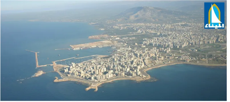
Tripoli: a city losing its spaces
Tripoli’s situation is different yet similar to that of Beirut. From an overview, the ratio of public space in the city is considerable, but that only tells half of the story. When looked upon more closely, it shows that, similar to the capital, the highest percentage of public spaces is concentrated in two bodies, the waterfront and the Rashid Karami International Fair (a one million square meter fair designed by the world-renowned Oscar Niemeyer). These two spaces can be compared to Beirut’s “corniche” or waterfront and its biggest park “Horsh Beirut”, which, like the fair, is not fully public due to several restrictions and concerns. In contrast to Beirut’s streets and roads, Tripoli’s streets allow more breathing space with wider sidewalks, more greenery and continuous uninterrupted spaces for pedestrians. The rest of the public spaces are small municipal lots, urban pockets and publicly used private lots.
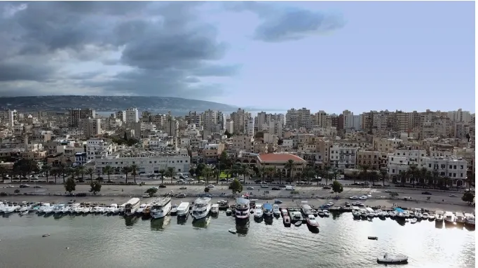
Corniche El Mina
The waterfront contours the municipality of Mina and attracts the most users of any public space in the city, especially on weekends and public holidays. The users come from all sections of society and all parts of the city. It is a space used for sports, leisure and fishing. The waterfront is not equipped with proper facilities by the municipality or the government but individual efforts, characterized by kiosks, concession stands and boat rides, make up for this.
Fig. 6. Corniche el Mina (image via Mina Municipality).
Lebanon Cities’ Public Spaces
Fig. 7. Corniche el Mina (image via Mina Municipality).
In a similar manner to “Corniche el Manara”, the waterfront of Tripoli remains the most successful public space of the city. On weekdays it is full of fishermen, joggers and cyclists while on weekends the Corniche is flooded by families, with their children, coming from as far as Akkar and Minnieh-Donnieh (one hour away from Tripoli). This space is also
connected to Mina’s old core, a maritime town, and to the islands dispersed in front of its coast; hence fishing, diving and swimming remain vibrant activities practiced along the corniche.
Rashid Karami International Fair
The second largest “public” or semi-public space, Oscar Niemeyer’s Rashid Karami international fair has everything a modern public space needs in terms of equipment, facilities and open space. This space is fenced, gated and all entrances to it are controlled. Not everyone is allowed inside, it is mostly reserved for the middle and high classes. Nowadays it is mostly used for walking and running outside of the times when it is
reserved for exhibitions and fairs. The municipality and the private sectors activate the fair scarcely for the yearly Tripoli International Festivals, the book fair and other exhibitions and forums (i.e. food, weddings etc).
The lost spaces
Scattered through the city are small municipal lots dedicated specifically to public gardens. The old city lacks a lot in that regard as very few lots are owned by the municipality, and those that are have proved to being under-maintained or under-equipped. Only very few municipal lots in the old city can be considered as proper public spaces and that is usually due to international organizations rehabilitating them. The most used spaces in a public manner in the old city are the “souks” or old markets. These markets, which were
Maryam Nazzal, Samer Chinder
Figg. 8 and 9. Tripoli International Fair (top image via Tripolientrepreneurs, bottom image by lebanoninapicture).
At night both the souks and the public gardens are rarely used as they are perceived as unsafe spaces; the lack of lighting in them and to them is one of the main causes of that perception.
Outside the old city, these municipal lots fall into three categories:
• Poorly maintained public gardens • Privatized lots
• Undeveloped lots
Few properly maintained public gardens exist in the city and this is due to expenses of maintenance and security. In order to avoid these fees, the municipality is signing Building Operate Transfer (BOT) contracts with the private sector to develop and operate these lots before returning their ownership back to the municipality after a certain number of years. These privately developed spaces become private properties that only seek financial gains, hence the city becomes more depleted of public spaces.
Lebanon Cities’ Public Spaces
the boundaries of the city act as picnic spots on the weekends, while building canopies offering shade on the sidewalk make good hanging out spots for the inhabitants of the neighborhood.
The current situation of public spaces in Tripoli can be summarized as: the
privatization of public spaces, the lack of spaces dedicated for public benefit, the plurality of actors and policies, the lack of maintenance and the lack of awareness when it comes to the rights and obligations of citizens.
References
Boustani, Marwa. “Sports, Public Space, and the City: The AUB/NI Project to Enhance Spaces for Sports and Social Interaction on the seaside/Corniche” American University of Beirut (2012) available at:
https://scholarworks.aub.edu.lb/bitstream/handle/10938/9800/monaharb-urbanplanningresearchmethods-aubnorthernedge-project-2012.pdf?sequence=1&isAllowed=y Chaaban, Jad. “Who Are the Stakeholders in Ras Beirut’s Seafront Pollution Management?” The
Neighborhood Initiative. American University of Beirut (2008) available at:
http://www.aub.edu.lb/ni/Documents/research/seafront_layoutproofed.pdf
Fawaz, Mona. “Reframing the debate to save what is left of Beirut’s shrinking seafront “ American University of Beirut (2016) available at: http://lcps-lebanon.org/featuredArticle.php?id=90 4. Madi, Christine. “A Short Story of Beirut’s Public Spaces” (2014) available at: https://www.area-arch.it/en/a-short-story-of-beiruts-public-spaces/
UN-HABITAT. Beirut City Profile working document (2016)
World Monument Fund. “Worlds Monument Watch” (2016) available at:
https://www.wmf.org/project/dalieh-raouche
To cite this article:
Nazzal, M. and Chinder, S. (2018). Lebanon Cities’ Public Spaces. The Journal of Public Space, 3(1), 119-152. DOI: 10.5204/jps.v3i1.323
This article has been accepted for publication in The Journal of Public Space. Please see the Editorial Policies under the ‘About’ section of the journal website for further information.
Maryam Nazzal, Samer Chinder
REGIONAL PUBLIC SPACE PROGRAMME FOR ARAB STATES
CASE STUDY TEMPLATE
GENERAL INFORMATION
Haddadine Public Space
Location, City, Country: Al Aswak Sahat al Daftar, Haddadine, Tripoli, Lebanon Year: 2017
Main entity involved: (NGO or otherwise): Municipality of Tripoli, Azm & Saade (NGO), and Haddadine local committee
Partners and funding entities: Azm & Saade, the Embassy of Switzerland and the Norwegian Ministry of Foreign Affairs
BACKGROUND INFORMATION
The neighbourhood of Al Aswak Sahat Al Daftar falls within the Tripoli municipality. It covers an area of 0.05 Km² within the community-defined boundary of Haddadine (approximate but not identical to the official Haddadine cadastre).
The old city where Al Aswak Sahat Al Daftar is situated is renowned for its historical character. Nearly 40 buildings are classified as heritage sites as they date back to the 14th century Mamluk period. The old city is also characterized by its historic mosques and Hammam, its operating old Souks as well as its traditional craftsmanship. The
neighbourhood’s population is estimated at 3,767 residents with 9% being Syrians and 1% Palestinians.
UN-Habitat Lebanon conducted a neighbourhood profiling identifying the main problems faced in the area. The findings show that there is weak collaboration between the
municipality and the residents, which in its turn leads to reliance on NGOs for assistance. Women and youth groups feel unwelcome in the neighbourhood’s public spaces. The former group reports a feeling of unsafety due to frequent harassment and lack of well-lit and accessible spaces. The latter group, which usually gathers in neighbourhood pockets, believes that they are regarded as terrorists in the eyes of the army as they cite frequent arrests.
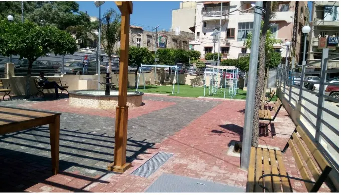
Lebanon Cities’ Public Spaces
Fig. 11. Haddadine Public Space: after.
PROJECT DESCRIPTION
Several vacant spaces were identified through the process of neighbourhood profiling: a playground for children in Al Najah School, a few private yards that can be turned into common spaces, a vacant pool, and the garden of Al Mansouri Mosque. The pool and the public space around it were selected for this particular project.
Located at a Western edge of the neighbourhood outside the old town, the vacant pool occupied the Azm Mosque roundabout. During the late 1990s, the municipality of Tripoli decided to create fountains at several roundabouts throughout the city. By implementing large fountains the size of a small swimming pool, the municipality inadvertently invited people who otherwise do not have access to swimming facilities to plunge into the water. The municipality eventually emptied them to prevent drowning and other swimming-related accidents. Before the design intervention, children were playing Football in the empty fountain and injuring themselves with the broken tiles. Moreover, the on-site presence of an EDL (Electricité de Liban) transformer with exposed cables posed an electric hazard to the children using the space. The pool and the area around it, altogether a total of 400 sqm, were cloistered with a high steel fence. The children would climb on an adjacent electric column to go over the fence and access the space (Figure 3).
Maryam Nazzal, Samer Chinder
The project of redesigning the Haddadine fountain space was aimed at turning it into a safe area that is accessible for the residents of the neighbourhood. This is especially true for the women in Haddadine who did not have any place to gather in the neighbourhood and socialize, as well as young children who were risking their lives to play in the fountain. In order to come up with an end product that can serve as a multipurpose common space, several key points had to be taken into consideration. Firstly, the idea of using local materials and local labour practices had social, economic and environmental dimensions. For it increases the ownership of local residents of the design, provides unemployed youth with a work opportunity, and saves cost and carbon emission from transporting new material from elsewhere. Secondly, the engagement of the direct users of the space also took shape through listening to their visions and implementing their ideas. The project was realized in partnership with the municipality and with Azm & Saade NGO. In addition, the users were assigned for the cleaning and maintenance of the space.
Challenges were met during the implementation of works as the contractor had to
collaborate with the local committee and employ unskilled labour from the neighbourhood. However, as the area is controlled by informal leaders, the gangs of these leaders
pressured the contractor to hire them. As a result, the residents of the area rejected the project at first but the problem was eventually resolved.
DESIGN AND IMPLEMENTATION
The residents wanted to keep the space fenced for safety reasons. On the other hand, it was crucial to make the fence more visually appealing. The harsh orange and yellow steel vertical bars with spikes were therefore changed and the fence became galvanized steel with horizontal bars on which drawings of children and young individuals can be displayed (Figure 4). It was proposed that buckets for planting could be installed on the fence with the names of the women who would use them. The sidewalks were made more accessible for pedestrians as they were widened leaving lesser room for cars to park. A ramp for individuals with physical disabilities was installed at the entrance of the space. The
transformer was additionally enclosed with a lock so that it would cease to pose any threat for young users especially.
Lebanon Cities’ Public Spaces
Storm water management was another matter that had to be dealt with. The space was paved with porous material in order to allow for rainwater to infiltrate. An underground reservoir was installed to collect the water for irrigation and to fill the newly designed fountain. For solid waste disposal, trash bins were set inside the space as well as big dumpsters on the outside.
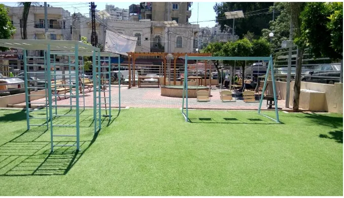
The space was divided into two parts with one being allocated for seating and the other as a playground for children. In the seating area, a water element remained the heart of the space yet was designed in a safer manner and with more adequate dimensions: a circular fountain of a 2.5 m diameter was constructed in the centre using materials from the walls of the old fountain (Figure 5). Surrounded with red and grey paved surfaces, the fountain became a pleasing focal element that can be filled with water without the previous risks. Two wooden pergolas, made by local workshops, were installed with wooden tables underneath and wooden benches on both sides of the pergolas.
Fig. 14. The new fountain was constructed out of recycled materials from the walls of the old fountain
Maryam Nazzal, Samer Chinder
Fig. 15. Divided into two sections, the space now comprises a seating area and a play area
OUTCOMES OF THE PROJECT/ RESULTS
On the 23rd of May 2017, UN-Habitat Lebanon organized in collaboration with the local committee, the municipality of Tripoli, and Azm&Saade an inauguration ceremony of the Haddadine public space. The event comprised short speeches by the stakeholders, ribbon cutting as well as animated activities for children.
In addition to the conflict that, as mentioned in the previous section took place due to the monopoly of informal leaders from the area, the maintenance of the space poses a big challenge.
Several design compromises had to be made with the municipality. Initially, transforming the whole 400 sqm to a Football area for children was proposed in the design. The municipality however insisted on dividing the space into two sections with one being for children and the other acting as an adult seating area. On the one hand, the outcome was positive as groups to whom the space was not previously accessible are now using it: Young boys and girls aged between 4 and 12 can now play safely; and women gather to watch their children play as they mingle in the seating area. On the other hand, there is now no room for teenagers to play since the equipment is only suitable for young children. Moreover, it was suggested in the main proposal that the wooden benches would be designed and constructed by local carpenters.
The kids used to say in the beginning that this space is for the municipality: now they accepted it as their own especially after several awareness campaigns were organized with the RTO (Regional Technical Office) and NGOs such as UTOPIA and Azm & Saadeh. The municipality of Tripoli is taking charge of the management and maintenance of the public space, also encouraging all active NGOs to use it for any event to keep the space active and accessible for all.
LESSONS LEARNED
As described in the previous section, the implemented design was met with mixed
Lebanon Cities’ Public Spaces
durable material possible is a must. In addition to that, dealing with fencing proves to be a complicated matter in contexts with socio-economic and political tensions. Enclosing a public space with a barrier is typically not encouraged as it is supposed to be both visually and physically accessible to everyone. Yet in this case both the municipality and the local committee urged the architects to keep the fence. Design conciliation was then to maintain the boundary yet to replace the existing one with a more user-friendly form.
Another valuable lesson is the importance of collaboration with various stakeholders. Coordinating with the municipality was crucial for the implementation. Nevertheless, without the involvement of the local committee as well as the NGOs working in the area, a sense of ownership of the space on part of the Haddadine residents would not have been sustained. For example as stated earlier the children attained an acceptance of the public space with the help of the campaigns organised by the RTO and the NGOs. Furthermore, the challenge lies in collaborating with the people who wanted to hijack the project, such as the informal leaders. It is important to keep in mind as well that compromises on the proposed design have to be often made in accordance with the various stakeholders and targeted groups.
REFERENCES
UN-Habitat (2016) Al Aswak Sahat Al Daftar Neighbourhood Profile Haddadine, Tripoli, Beirut: UN-Habitat Lebanon
UN-Habitat (2016) Al Aswak Sahat Al Daftar Neighbourhood Strategy Haddadine, Tripoli, Beirut: UN-Habitat Lebanon
REGIONAL PUBLIC SPACE PROGRAMME FOR ARAB STATES
CASE STUDY TEMPLATE
GENERAL INFORMATION
Project: Implementation of a safe, inclusive, and accessible public space in Naba’a Location ,City, Country: Naba’a, Bourj Hammoud, Lebanon
Year: 2016
Main entity involved: Municipality of Bourj Hammoud and Nabaa local committee Partners and funding entities: UN-Habitat Public Spaces Programme
BACKGROUND INFORMATION
Naba’a neighborhood is located within the municipal district of Bourj Hammoud, one of the eastern dense suburbs of Beirut. It is a low-income neighborhood spreading over 0.5 km², and has been accommodating a large number of Syrian refugees since the start of the Syrian crisis. The number of neighborhood inhabitants has increased from 22,000
inhabitants in 2012 to around 26,000 in 2014. Consequently, the municipality of Bourj Hammoud is overloaded with service and maintenance demands in shelter and
Maryam Nazzal, Samer Chinder
UN-Habitat Lebanon implemented in October 2015 a rapid profiling; the findings showed that 60% of inhabitants are Syrian refugees. The study also showed that barely any public spaces exist within the neighborhood, leading children to use streets and sidewalks as a play zone. Furthermore, due to the absence of adequate public spaces, 57% of interviewed women prefer to stay home to avoid street harassment. According to this assessment, a high rate of tensions from Lebanese residents towards Syrians has been detected since the former consider that Syrian refugees have contributed to a denser and more deteriorating neighborhood.
Fig. 16. Naba’a, Bourj Hammoud: before.
Fig. 17. Naba’a, Bourj Hammoud: after.
PROJECT DESCRIPTION
Lebanon Cities’ Public Spaces
vacant areas were identified but most of them were private. The only available vacant space owned by the municipality is located within a residential area in the heart of Naba’a and for with an area of 200 sqm. A formal approval was granted by Bourj Hammoud municipality in order to implement a public space design on this property. This space however was being used as a coffee shop known to be a hub for drug users. Therefore the first intervention in coordination with the municipality as well as the local committee was to remove the coffee shop from the site. The following steps were carried out as pre-preparation for the
intervention:
1) Creation of a local committee: As the UN-Habitat aims to engage the community in all phases of the project; a local committee was established in Naba’a (14
Persons)including key stakeholders and community leaders, i.e. Mokhtars, school directors, civil activists, representatives of active political parties as well as a representative from Bourj Hammoud municipality. The main objective behind the creation of this committee was to ensure that the main needs of the community are assessed and met in the design of the project as well as to ensure project’s ownership and sustainability.
2) Development of a Minecraft Model: The participatory design of the Naba’a public space was developed with the help of Minecraft Model, an innovative tool previously used by UN-Habitat in several countries but for the first time in Lebanon. A technical study was prepared by the responsible engineer from UN-Habitat, in order to collect all needed information about the site. A set of materials was collected including
photographs, Google maps and images, and GIS maps. The materials were then shared with the Minecraft modelers in order to start creation of the model which took around four weeks before the final validation.
3) Conducting orientation sessions: Prior to the Minecraft workshop, multiple orientation sessions were conducted with the community. The targeted groups were as follows: Group one involving children from 5 to 12 years of age, group two being adolescents from 12 to 18 years old, group three including youth from 18 to 25 years old group four for women over 25 years of age and a group of men over 25 years old (Figures 3 and 4). The selection of participants took into consideration gender aspects, the presence of Syrian refugees and the inclusion of persons with disabilities. The
orientation sessions aimed to introduce the project, provide basic awareness on public spaces (what is public space, typologies of public spaces, why public spaces are
Maryam Nazzal, Samer Chinder
Fig.18. Adolescents focus group.
Fig.19. Youth focus group.
4) Minecraft Training: 24 members from the community participated in a two-day
Lebanon Cities’ Public Spaces
participants were ready to start building and designing the Naba’a Minecraft model (Figure 6).
Fig. 20. Workshop facilitator introducing Minecraft to the participants.
Fig. 21. Participants of all ages building and designing with the Minecraft model.
Maryam Nazzal, Samer Chinder
Fig. 22. The participants translated their ideas into a Minecraft model
Fig. 23. Architectural drawings based on the Minecraft model
DESIGN AND IMPLEMENTATION
Lebanon Cities’ Public Spaces
entrance and the surrounding sidewalk of the site were repaired using interlock tiles with no mortar so that the water infiltrates and seeps into the green grass area (storm water reuse). Additionally, the sidewalk became more user-friendly as it is now accessible for individuals with physical disabilities (Figure 9).
Fig. 24. Preparation of the pavement. March 2017
The site itself was divided into three sides with a play-friendly soft surface: In the middle lies a green lawn with grey rubber surfaces on each side. Two steel tents were installed above parts of each of the rubber sections to provide shade and shelter from the rain and a resting area for parents escorting their kids to the space (Figure 10). Under the larger steel tent, concrete benches and picnic tables were arranged. In addition, a water tank was installed on the roof of the tent to irrigate the vegetation on site using the neighboring building’s water overflow. A gutter that collects rain water and discharges it under the grass was also added.
Maryam Nazzal, Samer Chinder
Different types of trees were planted in the lawn area. Ficus trees (scientific name: Ficus nitida) and Jacaranda trees (scientific name: Jacaranda mimosifolia) were placed along one of the fences of the site. Ficus trees are water efficient as they do not require much
maintenance and irrigation. Jacaranda makes excellent shade trees. In late spring, Jacaranda blooms with a beautiful and fragrant purple foliage. Planted in the middle of the space Albizia trees were planted (scientific name: Albizia julibrissin) (Figure 11). Albizia, also known as Persian silk tree, is a fast growing tree with ferny leaves and fluffy pink flowers that resemble feathers. Apart from its attractive flowers, it is characterized by a fragrant smell and by that it attracts butterflies. Henna plants were also added.
Fig. 26: Albizia trees as a focal element of the space, June 2017.
Planters were installed by the sidewalk to prevent cars from parking and blocking the entrance. An arched monkey bar for children was added. Solar lights were installed on all six corners of the site. As the participants favored fencing the site for safety reasons, it was enclosed with a light wire fence that allows for visual access to the space even when it is closed. The site has one access point being a gate from the street side that will be kept open from 10 am to 8 pm daily and the municipality will be in charge of closing it during night. Surveillance of the site will be ensured by a municipal guard, and the lights will serve as night surveillance to expose any possible attempts at selling drugs in this spot during the night. The municipality will in addition take care of the maintenance of the site.
OUTCOMES OF THE PROJECT/ RESULTS
Lebanon Cities’ Public Spaces
Fig. 27: Local Mime artist entertaining the children, August 2017.
A boy scout marching band played at the beginning of the ceremony, followed by the speeches and the official opening of the space. As soon as the ribbon was cut and the gate was opened by the municipal police, the children flocked after the clown into the green field, running, playing and waiting in line to climb atop the monkey bar (Figure 13).
Fig. 28: Children queuing for their turn to climb the arched monkey bar, August 2017.
The children now finally have a green space to play in. Women from the neighborhood have also started to bring their own food and gather at the picnic tables. The space will be used for future events organized by NGOs: Soon a roundtable is to be arranged by UN-Habitat Lebanon in coordination with the municipality to promote the use of the space by all local NGOs.
Nevertheless, several problems came across during and following the inauguration
Maryam Nazzal, Samer Chinder
last decision defies the purpose of keeping the space accessible for everyone, the
municipality felt obliged to undertake this step in order to keep the space from becoming again a hub for drug abuse.
LESSONS LEARNED
Security concerns can be a delicate matter in vulnerable neighborhoods with high rates of tension and drug abuse. While UN-Habitat team disagreed to fencing the space, both the local committee and the municipality insisted that a fence is crucial for averting previously existing troubles in the space. Moreover, the municipal guards were not able to fully control the situation and so it was finally decided that young men are restricted from entering the space. The design and use of any public space, including the Naba’a space, is therefore a work in progress shaped by the shifting social conditions within which it is entrenched.
It is obvious that local participation should be reinforced even after the design is
implemented. This will aim toward an increased ownership of the space. It is proposed that in the near future someone from the residents will be employed for supervising the space instead of the municipal police. The space will also be upgraded with the help of the locals: the benches and the walls will be painted with graffiti, and the small plants currently
occupying the planters on the sidewalk will be replaced with more visually enhanced trees. As mentioned in the previous section, the space will be constantly animated by events organized by local NGOs in the area. It is also important to note that this project would not have been possible without maintaining a strong collaboration between UN-Habitat Lebanon, the municipality as well as the local community.
REFERENCES
UN-Habitat (2016) Nabaa Neighbourhood Profile, Bourj Hammoud. Beirut: UN-Habitat Lebanon. UN-Habitat (2016) Using Minecraft for Community Participation. [online] Available from:
http://unhabitat.org/ [Accessed 20 July 2017].
ABI SAMRA PUBLIC SPACE COMPETITION
UN-HABITAT in partnership with the Order of Engineers and Architects in Tripoli recently organized a competition between universities for the design of a public space in Tripoli. The purpose of the competition was to support the municipality of Tripoli in obtaining a good design for one of its few remaining public spaces in Abi Samra, located within the City municipal boundaries. The design was developed through a structured process, whereby, students in Architecture faculties of 7 universities competed to offer the municipality with an appropriate and relevant design. The design was requested to be sustainable and conform to a budget falling between 1,300,000 and 1,600,000 USD.
The choice of land did not come at random. The municipal plot is located in the
Lebanon Cities’ Public Spaces
One of the objectives of the competition was to find design solutions that preserve the efficiency of the remaining green areas in parallel with the improvement of the human environment, with a clear and precise vision of the relation between the open green spaces, their proportions and their area, compared to the global planning and design standards.
A series of focus group discussions were conducted with local residents from Abi Samra, with a fair representation of gender/age groups (Children, adolescents, youth and adults) to pinpoint the needs of the community. During these discussions, participants complained about the scarcity of accessible and affordable public spaces in Abi Samra, and requested to have a multipurpose public space that can be used by all residents of the city.
The competition targeted students of Architecture faculties, 4th year level, and took place
during the fall-semester of 2017-2018. Students worked in groups of 3 to 6 persons, and the universities were in charge of selecting two projects internally that were submitted to represent the faculty.
The final Jury presentation were held in the Order of Engineers and Architects in Tripoli on the 9th of December, 2017 where 9 teams presented their projects in front of the jury
and one winning team was selected at the end. The jury members consisted of 5 academics and professionals coming from the American University of Beirut, the Lebanese American University and Tripoli Municipality, while there were lectures on different issues in Public Space design given by 3 different public space experts.
A team from the Lebanese University (Tripoli Branch), composed of 6 students, Ahmad Minaoui, Rouba Rima, Julia Katrib, Chaza Ghamraoui, Rachelle Shehayta and Sana Abdallah won first place.
Maryam Nazzal, Samer Chinder
Fig. 30: ABI SAMRA PUBLIC SPACE COMPETITION: the winning project, night view
I. Prerequisites
• 2 A1 layouts (841 x 594mm), horizontal or vertical layout, which should include:
a) A general master plan on 1:200 scale; b) A design concept/conceptual idea;
c) A graphic framework aimed to illustrate the project (i.e. plans, facades, cross-sections, diagrams) – choosing what to display and the relative scale is up to competitor’s choice;
d) 3d views - i.e. renderings, pictures, hand sketches; e) at least two significant cross-section on 1:200 scale;
• 1 Model: 1:200 scale;
• Bill of Quantities (Budget between 1,300,000 and 1,600,000 USD) • Brief list of Specifications
• A power point presentation including a short 3D animation
• 1 Report of 400 words, explaining your design intentions, targeted audiences,
planned activities and approach. It should be a relevant text explaining the project in a simple manner. The text shall include synthesis and written in English or Arabic.
II. Calendar/Key Milestones
• Official Launching of the competition: September 22nd, 2017
• Official Submission and Pin-up of Projects (2 projects per university): December
8th, 2017
• Final Jury Presentations and Selection of Winners: December 9th, 2017
Lebanon Cities’ Public Spaces
• Bernard Mallat, Architecture and Design Department, AUB • Carla Aramouny, Architecture and Design Department, AUB
• Dr. Yaser Abunnasr, Landscape and Ecomanagement Department, AUB • Hala Younes, Architecture and Design Department, LAU
• Azza Fatfat, Head of the Engineering Departmetn, Tripoli Municipality
The winning proposal
1. Site Analysis
Fig. 31: ABI SAMRA PUBLIC SPACE COMPETITION: the winning project, site analysis.
The site’s surroundings, like many other neighborhoods in Tripoli and Lebanon, was planned by the local authorities and developed by private developers. Architects and engineers are designing from above, prioritizing financial gain rather than the inhabitants’ well-being. It is a global problem that most of our modern cities are facing.
Our case in Abi Samra is very special, as the link with the old neighborhood is still clear and dominant, not only physically, but also in the mentality of the inhabitants.
2. Problematic
What defines a public space in Abi Samra? How to address the Syrian Refugees? Are public spaces and gardens in Abi Samra a good example? How to deal with the privatization of public spaces in Abi Samra? How can the inhabitants contribute in the making of their neighborhood? How to create a social hub that can hold multiple activities? How to deal with public spaces in new urban fabrics?
Maryam Nazzal, Samer Chinder
3. The project: Ô-live, the community hub
DESIGN PROCESS
Preserving the collective memory of Abi Samra
Creating a social alley
Curvy path: -Suspense
-Different perspectives -Public space in constant innovation
Creating a community sharing zone:
-Facing the pedestrian flow -Generating curiosity
A second path allowing a longer walk
A network of dynamic paths encouraging relatedness
Every node is a perspective changing point
Lebanon Cities’ Public Spaces
Maryam Nazzal, Samer Chinder
The main aim was to preserve the collective memory of this area as “Zaytoon” (Arabic for olives) surviving in the face of the urban expansion. A social alley was introduced into the project to create a bond between the users themselves and the olive trees and add the elements of suspense, innovation and playfulness. A second longer pass was added to generate perspective changing nodes allowing for the establishment of several community engagement zones.
The community was engaged in both the assessment phase and the design process;
inhabitants of the direct neighborhood, inhabitants of the surrounding area and students of surrounding universities and schools were interviewed. The interviewees, out of which 60% were females, were asked about the frequency of using public spaces, modes of
transportation, their practiced activities and security issues related to the public spaces. They were also asked to propose activities, designs and facilities for the proposed space. Rather than revolution, the project focuses on evolution.
Project’s Ambition
• Improve the social interaction in the neighborhood and create a social hub that can
help in building communities.
• Make the people involved in designing a new extension of Abi Samra. • Create a physical expression of the collective memory of old Abi Samra.
Design Strategy:
• Offering opportunities for impact.
• Considering ourselves as: - Expert citizens - Story tellers - Translators - Not to
impose architecture.
• Considering Architecture as an emotional relationship and a piece of crafted art. • Creating a place for buildings local communities and sharing. The main purpose is to
allow people to communicate & relax wherever they see fit, as well as to ideate, collaborate, work, produce, restore.
Design elaboration
Considering that the plot is one of the last remaining municipal lots in old Tripoli, the aim was to preserve its identity, and create a social alley that links two main entrances. These entrances were located based on the surrounding built density: a light zone and a dense zone. This social alley is a curvy, fluid and dynamic path which allows different points of view and perspectives and gives up a richness of perspectives, as well as stimulating suspense.
This main path determined the main functions:
• A community sharing zone where the flow of pedestrians is the most important. • A spiritual space situated in front of the mosque.
• A calm area also called “the olive trees promenade” embodying the collective
memory we previously mentioned.
Every design element along this path is a sort of “folly”, where the path acts as the main link between these structures.
Lebanon Cities’ Public Spaces
Zoning and Vegetation
The vegetation used in each zone depends on its function:
• For the communion space, where people interact, get to know each other, and
gather, fruitful and aromatic vegetation were used.
• For the piazza, the oak tree is there to evoke the Lebanese tradition of gathering
under its shadow.
• In front of the mosque, where the spiritual zone is, a barefoot walk was designed. It
is a sequence of organic pavement cells (like wood, gravels, mud and others…) based on the Chinese treatment called reflexology.
This walk represents the social act of taking of the shoes before entering a mosque; it embraces a green lawn opened to sky as a negative space for the people to enjoy the sun heat. It can also hold religious events during “Ramadan” and Eid for
example.
• The olive promenade includes wooden furniture, having different aspects: low
wooden decks under the olive trees and benches with photovoltaic panels. In addition to olive trees, eucalyptus trees are also there to give shade and protection from the south-western wind.
• The kids zone was named the jungle fever; it includes two follies or structures as a
stylization of playing in the jungle. Children can create their own game on the same structure.
Architectural follies
As previously stated, the main path links “follies” or structures located in different parts of the project. The follies are multifunctional structures and each one of them evokes a different mood. The multipurpose room is the main architectural structure. It can be modified using sliding panels transforming it to a multipurpose room, in a minimal and in a simple way, assuring its openness to the piazza.
To further emphasize on the multi-functionality, movable acoustic partitions would be installed, giving more layouts. 4×4 grids in the interior space, the same spacing that is the norm spacing between olive trees, is used. This gives many possibilities to use the space according to the needs.
As for materials, the façade panels were made of translucid polycarbonate panels allowing good lighting on the inside. This structure will be as well, a place for vine to grow, giving shaded areas. In addition to that, and under these structures, “corners” are integrated: a sort of shelving system that the community can use to donate their clothes and belongings to the less fortunate. This idea is in fact already in use in Tripoli; a cafeteria in Abi Samra uses the same system, and along with the act of good will this operation insures an interaction between different tranches of society.
The Atop folly is located at the end of the communion zone overlooking the olive trees promenade, while the cafeteria is located at the highest point of the project overlooking all the zones and spaces.
The Multipurpose structures
Maryam Nazzal, Samer Chinder
People usually tend to search for what is new and different to explore it. This allowed the design of a livable, changeable and dynamic space to kill this routine.
To emphasize the concept of the participatory approach, the idea was to put permanent multifunctional structures that can accommodate people’s interventions. Pre-made and hanged samples will help in making this new idea more familiar to the public guiding people to imitate them, unleashing their creativity.
Here are several proposals of what these samples can be:
• Exhibition space.
• Suspended garden, where plastic bottles and other recyclable objects are
used. Here the previously mentioned schools are welcomed to have educational trips for their students to practice the concept of reusing, reducing and recycling.
• Artists are equally involved to frequently display their art. Surrounding
architecture, arts faculties and schools will have an important role in including their students in the design process of these installations.
Furniture and Fence
All furniture is sustainable and movable in the entire project. It is made out of recyclable materials, thus encouraging waste sorting.
Competitions can also be held in order to create the best designs.
Fencing the project was an obligation imposed by the municipality due to security constraints. Thus, two main types of interventions were applied:
• Near the Community Sharing Zone, the aim was to assure the most possible
transparency with the outer road, where the flow of people is very high, in order to attract users to enter the park.
• Near the Olive Trees Promenade where calmness is needed, the fence used is
semi-transparent.
In fact, to integrate the fence with the context of the park, botanic architecture is used to allow tree branches to become strong structures. To do so, steel columns are used to mold the growth of the climbing vegetation, years after, when the branches will take the desired shape, the guiding steel columns will be removed keeping a totally natural fence.
Sustainability
The used vegetation in the garden is wild, native and local, which helps, besides conserving the collective memory, in reducing the needed maintenance and in saving water.
Roofs are covered with PV panels in order to generate power for the project. A rain water collection system is used to feed the irrigation system.
Maintenance and administration
• The municipality organizes the renting process. • NGOs and beneficiaries organize the events’ schedule.
• Solid waste is collected by the LAVAJET, the same company that operates for the
Lebanon Cities’ Public Spaces
Olive’s financial resources
• The rent of the cafeteria.
• NGOs renting the multipurpose room. • Workshops.
• Food villages and daily or weekly markets.
The winning project ‘Ô-live, the community hub’ was presented at the 9Th World Urban
Forum in Kuala Lumpur - http://wuf9.org/programme/urban-library/o-live-community-hub/
Fig. 34. The winning team of the ABI SAMRA PUBLIC SPACE COMPETITION, the O-live, the Community Hub,
at the 9th World Urban Forum in Kuala Lumpur (February 2018).
Top: group picture with the six students of the Lebanese University (Tripoli Branch) Ahmad Minaoui, Rouba Rima, Julia Katrib, Chaza Ghamraoui, Rachelle Shehayta and Sana Abdallah
and with Samer Chinder (UN-Habitat Lebanon), Gaby Khoriaty (BANAKO Architects Lebanon), Luisa Bravo (City Space Architecture / The Journal of Public Space)
and Jarunee Pimonsathean (Thammasat University, Thailand).