ISSN: 2334-2420 (Print), 2334-2439 (Online) Copyright © The Author(s). 2014. All Rights Reserved. Published by American Research Institute for Policy Development
Spatial Organization of Gurgan city in Islamic Period (On the basis
of Archaeological Findings and Documentary Sources)
Dr. Abed Taghavi1, Dr. Rahmat Abbasnejad2, Dr. Saman Farzin3
Abstract
Jurjanor Gurgan is a city that remains from the Islamic period have been located in 3 kilometers from the western current city of Gonbad-e-Qaboos. The foundation of the city as a fortress in the late Sassanid era was formed in the early centuries of Islamic rulers in the early development of local Samanids his vast experience and reach 300 hectares approximately. The second stage of urban development in this city that the final stage of development the city is considered in the Seljuk era succeeded and the extent to which more than 1200 hectares. This paper approaches utilizing methods common theoretical study of spatial organization in the city using the findings from archaeological research and written sources and historical geography. The results of this study indicate that residents in the establishment of two Sunni and Shiite, each with evidence of various urban spaces, to reflect a political and religious ideas in the form of the rulers and the has been expanding various parts. Place core and the central city, the changes left and semi-independent elements(total small) such as the mosque, citadel, market , square andJurjan urban structure have been developed from the military is an important part of its regular network of streets, including main and sub-parallel to that, they cut each other.Beautification of urban spaces with decorative brickwork floor carpets Street, effluent disposal by surface hub of waterways (channels) through which underground water pipe was driven by clay, including features in the form of spatial organization is Jurjan city. Form and analysis of two point spaces in city government when Seljuk Samanid and that facilities for residents of the civil disorder and has a logical layout with the city on the Silk Road , city's economic prosperity in the medieval period used the frequency of interest.
Keywords: Islamic city of Gurgan ,jurjan, Archaeological excavation ,Spatial organization , Samanid , Seljuq , Urban space
1 - Assistant Professor, Department of Archaeology, University of Mazandaran
2 - Assistant Professor, Department of Archaeology, University of Mazandaran
1-Introduction
As a new approach of social archaeology are focuses in interaction of space and society in the past human culture. In this interaction, space is intricate complex political, economic, social and cultural evolutions that are considered to be come the close relationship between the people and political and economic power. Generally, Itwill rise in the form of governmentin the Islamicperiod, due to human settlement in the context of the Islamic city and existence of differentpower forms, have been more seriously itself. Thus,human and his behaviors be manifested in a more organized society as aCity. Spatial Archaeology seekslogical connections between the discovery of architectural spaces and features of form and functionthem. Scholars thatresearches in this field are emphasis that spatial analysis of architectural remains, created at first, based on request of society, and later reformed according to another requirements. Moreover, the aim of spatial archaeology is cognition ofspace structureand spatial relationship between components with together. Also, theimpact of political, economic and religious indicators have caused changes spaces in form and function. Wherever,in the Islamic era existed various forms of power in Iran and northern cities have sharedinoccurred substantial developments.thus, in this article tries to study focusing on spatial organization and the city during the Islamic Jurjan and theoretical analysis to be paid architectural spaces in two Macro-scaleand micro scale. In the large scale part, has been studied political and social conditions and progress of formation, development and destruction in urban society of Gurgan. On the other hand, the spatial analysis have paid micro scale and also have been considered complexity of formby the type of urban spaces and architectural elements.
2- Gurgan(Jurjan) in the Documentary Sources (Historical and Geographical Documents):
During the Parthian and Sassanid to providing of security in the northern borders of Iran was built military fortifications and defensive walls in the great plains of Gorgan.
He said that Jurjan constructed by Yazid-ibn-Mohalleb-commander of Arab troops in the conquest of Jarjan (Tabari, vol 9: 3937). Balazeritold us that Jurjan have been wall and fortsin whole of city (Balazeri, 1337: 473-471). The Abbasids to power up and extendingtheir territories in north of Iran. they were sent governors to this region to manage political and economic administrations in GurganProvince. Being lengthening Abbasid Caliphate, local rulers refusedfor Policy Center of the Caliphate in Baghdad, heavy social pressures resulting from land taxes and duties ,also stabilized against the Sunni minority, Shiite religious movements have considered main causes of political conflicts Alavian In Tabarestan and Gorgan. For example , can be indicate such as battles between Abo-al khozeyb andEspahboud(Ibn Isfandiar, 1366: 174), rebellion of Maziar-IbnQaran (Mojmal-al Tavarikh, 1318: 358-357) and Hassan Ibn ZaydAlavi (Tabari, vol 13: 9-6138). Thus, despite the insecure political atmosphere and mentality of local government Tabaristan and Gurgan against Arab (Zarrinkub, 1364: 465) was builtGarrisonsinTabaristan and Gurgan by Abol Abbas Toosi- Governor of the Abbasid Caliphate in the region- (141-143 AH.). (Ibn Isfandiar, 1366: 178; Amoli, 1348: 61; Marashi, 1345: 60). With Performance of this insight and controllingof political boundaries began the emergence of governance arrangements and local independent such as Al Ziar and Alavian. In Great Khorasan and Sistan,Samanid,Taherian and Safarian added to their territories and states,whereas Gurganwere riding and the new arena and their possessions (Narakhshy, 1363: 305-304; Tarikh-e- Sistan, 1366: 224 -223;Madelung,1381:180-179).
Indeed ,Most of our knowledge in historical geography fromJurjanCity is fromMuslim geographers of the fourth century AH. they give us very important information about culture, economic, policy and so on. Some geographers, have considered part of Qumis , Khorasan and Tabaristan.(Ibn Rosteh, 1365: 122-112; Ibn Khordadbeh, 1371: 59; Abolfada’, 1349, 506; Ansari dameshghi, 1382: 32). Ibn Huoqelindicates that Jurjan isafter Ray and Iraq cities, most cities of Iran. It is divided to twomain Quarter: Shiite area called "Sharistan" and Sunni area calle "Bakrabad".These two parts respectively, were established inEast and West (Ibn Huoqel, 1366: 124). The core of city called, shahristan (Ibn Faghih, 1349: 180).
According to the Maghddasi,quarters of city has been consistof nine alley as following : "Soleyman", "Qumisian", "Rahian", kandeh", "Badenjan", "Khorasan", "Barghah", "Bakrabad" and "Shahristan".
Mosques and markets in "Bakrabad" quarter has been decorated with wall paintings. In the central city locatedPalace of governor. Cemetery was placed across the river in the city of Gurgan that goes by the wooden bridge and brick to connects city(Maghdassi1361:524).
Geographic sources pointed that theGurgan River called Gurgan rood. It originated from Deylam Mountains and traverse the long path to the City divided into two parts and also eventually has fallen to the Caspian Sea (Hodod-al-Alam, 1361: 143; Khazraji, 1354: 83; Abolfada’, 1349, 506; Ansari Dameshghi, 1382: 168; Hafez abrow, 1375: 166). Also Jeyhaniand Qazvini are considered Gurganto this River has navigability (Jeyhani, 1368: 148. Qazvini, 1373: 411). Written sources memorized of high quality silk by products and other major cities such as rice and fish(Bartold, 1377: 39). Another productsof Gurgan can indicatesuch as, figs, olives, melons, jujube and bergamot (Ibn Hougel, 1366: 124. Maghddasi, 1361: 520 .)
3- New Archaeological Excavations in Gurgan Old City
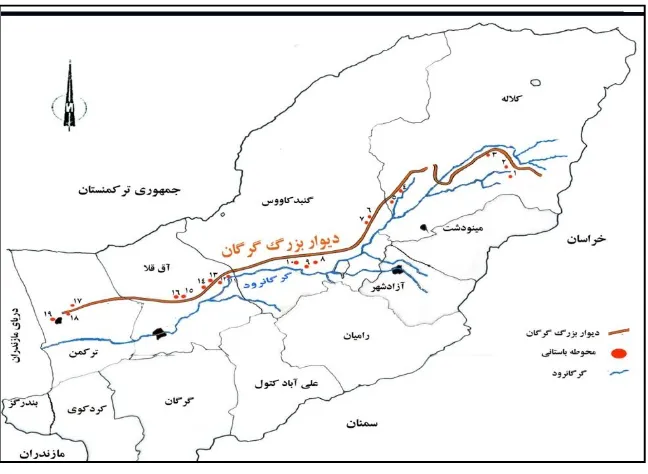
Firstly,extensive archaeological excavations in Islamic city of Jurjan headed by Professor. Mohammad Yousef Kiani by since 1350 to 1357.Consequently, led by Dr. Mohammad Mortezaiesince1380 to 1384.according to excavated partsdiscovered numerous architectural spaces including streets, administrative building, Bridges, Industrial Workshops, monumental buildings, residentialquarters.(Figure2). Studies show that the Jurjanhas long brick wall with stone and mud mortar Sarouj. It has been enclosed and also has contained surrounding wide and deep moat. Unfortunately, there isn’t any data about of the actual height of the wall thickness and fortification city. Due tomost of moat and fortshas been lost in development and use of agricultural land by residents (Kiani, 1365:231.Mortezai,1386:335).
Evidence determined that most Commercial, administrative and religious centershave been formed in the early Islamic period around the same building (Arg)(Kiani,Mortezai, 1385: 113). Citadellocated in the Shiite quarter.it has been the main core of the city.
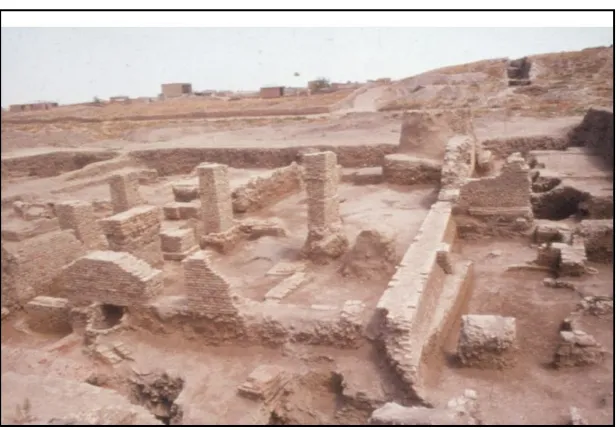
In the center of jurjan, there were a mosque- school(Masjed-Madresseh) that has four porch and was built on two floors. This buildingyard that belonged to the Seljuq period. ithas been dimensions of rectangles 13.80 X 16.40M.Surrounding rooms was several dimensions such as 4 X 4 m and 3.25 X4.50 meters. Yard was carpeted with a brick floor and the mosque entrance had been built in the northern side through a vestibule and hallway connected to the central courtyard (Kiani, 1365: 234). In the North side of the mosque, located construction of underground rooms with three floors that each of them had been carpeted with square and hexagonal bricks. In the southwestern side to exists spiral stairs (Fig. 3)
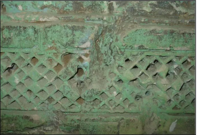
it probablymake up base of the mosque minarets(Kiani, 1383: 91). Today ,sections of the altar and fragments of stucco decorations, wall paintings and inscriptions of the mosque were protected in YahyaIbnZeyd shrine near the city ofJurjan( figure4)
Constructed Bridges in Jurjan belong to Seljuq Period. Material used this building consist of Brick with Sarouj Mortar.
Networking of streets in this city has been included four axes. For example, Avenue stretches from north to south and from East to West had been constructed. Network design scheme across the city revolving Street North West, South and East led to regular and quick connect different parts of the city. It is interesting that in side the main city streets work out walking spaces. Also,for transfer and disposal of sewage effluent work -out channels with pottery pipes. It called Tanbousheh. On both sides of the main street, there are some chambers probably usages as a place they traded. It probably has been displayed the kind of prototype of the market space(Bazzar).
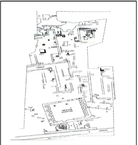
Generally, Researches shows that the workshops constructed and developed along the main streets (Mortezaei, 1386: 304, 291). (Fig. 5).
City quarters and residential areas has been located around the shrine and near of the ruins fortifications.Archaeological Excavations show that this part belong to Samanid and Seljuq periods. Evidence determined One of these buildings that including a yard, rooms walls and streams. they have been made from bricks andplaster. (Kiani,1365:233).
Recent archaeological research that was conducted by MohammadMortezaie, confirms that residential areas and city quarters in Jurjan belong to three period:
1-Samanid, 2-Seljuq 3- Ilkhanid(Mortezaie, 1386: 256).Architectural characteristics in ilkhanid period, including the using of brick and torn thatch, re-use of pre-architectural, building and construction of the wall of the enclosure was followed without walls in residential units(Fig. 6)
4- Conclusion
nodoubt, According to written sources and archaeological evidences, urban planning of Jurjanwas formed as polygon angles thatwas developed in both directions East and West. Major elementshave been including the defensive walls, citadel, mosques, streets, main streets, markets, workshops , industrial and residential areas (Kiani, 1365: 235,231).
Basically,Islamic Urbanism inJurjanare divided to two periods: 1-Samanid era 2- Seljuqera. Though, during the ZiaridsDynasty ,Jurjan has been as capital in beside of Rayy(462-315 AH.) (Ehlers, 2001: 143; Bartold, 1377: 142). One of the Monumental masterpieces in this eracan be indicate to tower Gonbad-e-Qaboos (397 AH.) that constructed by order ofQaboos-Ibn-Voshmgir-Fourth governor ziarids(Kiani,1379:45-44).
However, early physical extensions were accrued insamanidperiod.Jurjanat this time, extended to 300 hectares,approximately. In seljuq era, final stage completed and reaches to 1200 Hectares.
Author believes that ethnic and religious conflicts in the medieval cities such as Nishapur,Rayyand Jurjanhave caused that strengths the violence’s between Sunnis and Shiite minorities. This matter were determined one of the reasons for lagging of cities. Also, it has been reflected in spatial organizations to different parts of Jurjan.OccurredPoliticalevolutions in the Seljuq and Samaniddynasties has changed form of city completely. Central part(core) city was formed in Shiite area that called Shahristan. It was 300 hectares approximately.While at the same time, in Bakrabadquarter(Sunni area),peoplesuffered severe deprivation in western part of the city. With the establishment of the SeljuqGovernors, Sunni area(Bakrabad quarter) developed andspreadto 1200 hectares ,approximately. So, Seljuq rulers were patronage good forSunni areas. It has been caused that interferenceethnic and religious affiliations. It has impacted on the formation and development in Jurjan. Hence, can be inferred that the city of haven’t any peaceful coexistenceand people have been political and religious tensions, constantly.
City Territory includes two parts. Fortification and barrier. Forts has been functioned asartificial and the Gurganriver as a natural territory. Like other cities, Jurjan has separate cemetery outside the city. It located in western part.Indeed that chosen location of cemetery have been conducted for attention to health and to prevent spread of contagious and infectious diseases.
There are some factors in social life a society that were caused decline and collapse.For this matter, obvious examples are Political conflicts, famine and drought, disease and natural events. The social history of Jurjan , invasion of Mongols in 618 AH be considered as introducing points of theof process of political and economic decline(Mostofi, 1362: 197).Due to large scale destruction and lack of adequate facilities was replaced Astarabadas center of province. Although, the Timurid tried to rebuild the city, but they never succeeded(Hartmann, 1991: 1141). Moreover, subsequent earthquakesadded to declines in 834 AH , 874 AH and 903 AH. Consequently, earthquakes was caused people leave it for a long term.( Melville, 1370:154,150).
The results of researches show thaturban spaces of Jurjan in destructed in qajar and Pahlavi era, completely.In this period, people used to local material of old city for their buildings
References
Abol Fada,1349, Taghvim Al-Boldan,Tehran,BonyadFarhang Iran. Amoli,1348, Tarikh-e- Rouyan,Tehran, Boyad-e- Farhang-e- Iran. Ansari Dameshghi,1382,Nokhba-al dahr,Tehran, Asatir Press. Balazeri,1337,Fotouh-al-Boldan, Tehran, Ghatreh press.
Bartold, Joghrafiye-e- Tarikhi-e- Iran,Tehran, AfsharMoghoufe Press.
Ehlerz,2001,Dasht-e-Gurgan,Encyclopedia Iranica, edited by EhsanYarshater,VolXI,New York, Bibliotheca press,pp:142-45.
Hafiz Abrou,1375,Joghrafi-yaye- Hafiz Abrou, Tehran, Nashr-e- Miras-e- Maktoob.
Hartmann,1991,Gurgan,Encyclopedia of Islam, edited by Lewis .B and et al, Leiden, Netherland ,PP: 11-41.
Hodod Al-Alam,1362,Tehran, Tahouri press.
Ibn-Faghih,1349,MokhtaserAl-boldan,Tehran,Bonyad Farhang Iran press. Inb-e-Isfandiyar , 1366, Tarikh-e- Tabaristan, Tehran, KelalehKhavar Press. Ibn Hougel,1366, Sorat-al Arzz,Tehran,Amirkabir.
Ibn Khordadih,1371, Masalik –O- Mamalik,Tehran, Miras-e-Melal press. Ibn-Rosteh,1365, Aalagh-al-Nafiseh,Tehran, Amir Kabir Press.
Jeyhani,1368,Ashkal Al-Alam,Tehran,Astan-e- Ghods-e- Razavi.
Kiani,1365, NazariIjmali Bar SharneshinivashahrsaziIran,Tehran, Sazman-i-Ershad-e- Islami. Kiani,1383, Shahrneshinivashahrsazi Iran Asr-e- Islami, Daramadi Bar Shahre-e
Jurjan,Tehran, Pazhohesh hay-e- Farhanghi Press.
Khazraji,1354, safarnamihAbodalaf,Tehran,FarhangIranZamin Press.
Madelung,1381,Selsele hay-e- Shomal –e- Iran, I n Tarikh-e- Iran, Tehran , AmirKabir. Maghddasi, Ahsan –Al Taghasim Fi Marefat Al- aghalim,1361, Tehran, Sherka-e- Motarjeman
Iran.
Melvill,M.1370, Tarikh-e- Zaminlarzehhaye-e- Iran,Tehran, Aghah Press.
Mortezaei , 1386, The Survey of construction of Cultural and natural Jurjan , Ph.D Thesis , Islamic Archaeology, TarbiatModares university.
Mostoufi,1362,Nozhat Al-gholoub, Tehran, Donya-e- Ketab.
Marashi,1345, Tarikh-Tabaristan, Rooyan and Mazandaran,Tehran,Shargh Press. Mojmal Al-Tavarikh,1318,Tehran,kelale Khavar,
Narakhshi,1363,Tarikh-e-Bokhara,Tehran,Toos press.
Qazvini,1373,Asar Al BeladvaAkhbar Al-Ebad, Tehran, Amirkabir. Tabari,1375, Tarikh-e- Tabari, Vol 9, Tehran, Asatir Press.
Tarikh-e-Sistan,1366, Tehran, Kelalekhavar press.
ZarrinKub, 1363, Tarikh-e- Iran, Tehran, Amirkabir press.
Fig 2. Urban Structure of Gurgan in Fifth and Sixth AH
Fig 5: Pottery Workshop Plan in Jurjan City