410 | P a g e
SEMI-SUPERVISED HIGH-RESOLUTION IMAGE
CLASSIFICATION USING CRF MODEL
1
Komal V. Rayate,
2Shyamrao V. Gumaste
1,2
Department of Computer Engineering G.E.Ss R.H.Sapat C.O.E.M.S and R,Nashik,
Savitribai Phule Pune University(India)
ABSTRACT
Images which is of high resolution have the type of plentiful statistical and detail information, which are useful for detailed classification. The predictable algorithm combine spectral cues, spatial contextual cues and spatial
location cues by using probabilistic potentials. By using equivalent potentials the split trainings of easy classifier is well applied. Experiments Hyper-spectral images display well-built depen- dencies diagonally spatial and spectral neighbours, which are very helpful for classification of hyper spectral image. High-
resolution images have the type of abundant statistical and feature information, which are helpful for detailed classification. By using probabilistic potentials the classification algorithm which is based on conditional random fields(CRF) is existing algorithm merge spectral cues, spatial contextual cues and spatial location cues.
The unary potentials used on spectral cues and give the basic information about various land-cover classes. The pair- wise potentials applied on spatial contextual cues, it deals with the neighbouring connections between different pixels to deal with spatial smoothing. The higher order potentials deals with the spatial location cues. The target pixel and its nearest training samples interacts in higher order potentials which consider the non local range of spatial location. Useful information is provided for the classes that is similar to the other land-cover types which confused with the other classes of spectral appearance. The CRFSS algorithm add spectral cues, spatial contextual cues and spatial location cues in a CRF framework to offer contradictory in sequence from changing perspectives, so in remote sensing images it address the common problem of spectral variability , so because of this classes of each class and the average accuracy is reflected.
Keywords: Conditional Random Fields, Detail preserving smoothing classifier, Markov random
field, Support vector machines.
I.
INTRODUCTION
In remote sensing, main undertaking is land-cover classification. Hyper-spectral image classification has a
demanding focus of land-cover classification investigate because hyper- spectral image include rich spectral
quality, the categorization, identification and classification is done of land -covers which increase accuracy and
robustness [1]. To each pixel in an image a predefined semantic labelling is done in classification. This
Quick-411 | P a g e
Bird, and ROSIS) can provide profuse available data for accurate earth observation of high-resolution images.urban planning, precision agriculture, security applications, and damage assessment for environmental disasters
these are the application domain of high- resolution remote sensing imagery.
A huge amount of images for various thematic applications are available for functioning imaging system.
1. Ecological science: To study land cover vary or to approximation biomass, biodiversity are used in Hyper-
spectral and spatial images.
2. Geological science: Properties such as composition and abundance are used to recover physiochemical
mineral.
3. Hydrological science: To resolve changes in wetland characteristics is used in Hyper-spectral and spatial
imagery.
4. Precision agriculture: To classify agricultural classes and to remove nitrogen content in Hyper-spectral and
spatial data for the point of precision agriculture[5].
5. Military applications: For objective detection the rich spectral spatial information is used.
To improve the performance of classification and to make full use of the spatial information and spectral-spatial
classification many researchers have complete deal of endeavour. For spectral-spatial classification the
probabilistic modeling methods have successfully used. And the probability map is first obtained by pixel-wise
classification. Probabilistic modeling methods represents each land cover classes by each pixel. To consider the
spatial information the probability map is use of local filtering or extended random walker method [3]. To
implement smoothness in object-oriented classification method the another obvious way to regard the spatial
information. The goal of spectral spatial classification the main object oriented classification approach is to merge the classification and segmentation algorithms. In segmentation, divide the image into homogeneous
objects and then calculation of majority voting strategy is applied on the basis of pixel-wise classification or
direct classification and this is used to give the labels of various land cover classes, taking objects as the basic
unit.
II.
REVIEW OF LITERATURE
A detailed Literature survey[14] conducted by analyzing adequate papers on Image Processing which helps in
developing a new hyper-spectral image classification algorithm is based on the discriminative conditional
random fields (CRFs) to the same time deal with the problems mentioned previously.
Mathieu Fauvel, Yuliya Tarabalka et all in their paper entitled Advances in Spectral-Spatial Classification of
Hyper-spectral Images focused spectral spatial classification of hyper-spectral images is addressed.
Morphological profile of the image, which contain characteristics about the size of the image, orientation, and
contrast of the spatial structures present in the image is first used to derive in mathematical morphology. To
derive additional features for classification are defined and used in the morphological neighbourhood. SVM
which is used to avail the spectral information and the extracted spatial information through that the
classification is performed [2].
Gabriele Moser, Sebastiano B. Serpico, et all in their paper entitled Land-Cover Mapping by Markov Modeling
412 | P a g e
spatial- contextual information in the discrimination of land-cover classes has allowing for the Markovian,region-based, and texture based approaches to the modeling of this information in land-cover classification
techniques. Examples of processing results is obtained by classical and advanced Markovian classifiers in the
application, presenting diverse types of land covers and of spatial image behaviours [3].
Donald Geman ,Stuart Geman , et all in their paper entitled Stochastic Relaxation, Gibbs Distributions, and the
Bayesian Restoration of Images focused the role of Gibbs distribution, Markov random field (MRF)
correspondence it converse the energy usefulness is a more fitting and natural mechanism for represent picture
feature than the local characteristics of the MRF. For a variety of squalor mechanisms, with blurring, nonlinear
deformations, and multiplicative or preservative noise, the subsequent distribution is an MRF with a structure
similar to the image model[4].
Farid Melgani, Lorenzo Bruzzone , et all in their paper entitled Classification of Hyper-spectral Remote Sensing
Images With Support Vector Machines focused the role of Hyper-spectral Remote Sensing Images, attend to the
problem of the classification of hyper-spectral remote sensing data using support vector machines. In order to
consider the competence of accomplished classification methodology. This aimed at assessing the properties of
SVMs in hyper-dimensional spaces and hyper-subspaces of various dimensionalities [5].
Vladimir Kolmogorov, Aseem Agarwala, Daniel Scharstein, Olga Veksler, Marshall Tappen and Carsten
Rother, et all in their paper entitled A Comparative Study of Energy Minimization Methods for Markov Random
Fields with Smoothness-Based Priors focused the role of Markov Random Fields where the increase of
proficient energy minimization algorithms for pixel-labeling responsibilities such as depth or texture calculation
is done. Algorithms such as graph cuts and loopy belief propagation (LBP) have established to be very
established. For example, such technique form the base generally all the top-performing stereo methods. Here,
represent a set of energy minimization benchmarks and use to evaluate the result excellence and runtime of
some common energy minimization algorithms[6].
Runsheng Wang, Ping Zhong, et all in their paper entitled Learning Conditional Random Fields for
Classification of Hyper-spectral Images focused the role of Hyper-spectral images where Hyper-spectral images
reveal well-built dependencies across spatial and spectral neighbours, which have been establish to useful for
hyper-spectral image classification. Over-smoothing and over fitting are the essential methods used to categorize
the hyper-spectral images using conditional random fields [7].
Jocelyn Chanussot, Jn Atli Benediktsson, Yuliya Tarabalka, Mathieu Fauvel, et all in their paper entitled SVM
and MRF Based Method for Accurate Classification of Hyper- spectral Images focused the role of Accurate classification which current new challenges to image investigation and classification refer the high number of
spectral bands obtain by hyper-spectral sensors enlarge the potential to discriminate corporeal materials and
objects, presenting new challenges to image analysis and classification[8].
Runsheng Wang, Ping Zhong, et all in their paper entitled Modeling and Classifying Hyper-spectral Imagery by
CRFs With Sparse Higher Order Potentials focused on the role of Sparse higher order potentials which have
been proved to be very helpful for hyper-spectral image classification, which expose the well-built dependencies
413 | P a g e
image classification with sparse higher order potentials, which are mainly considered to merge complexcharacteristics of hyper-spectral images [9].
Xiuping Jia , Guangyun Zhang et all in their paper entitled Simplified Conditional Random Fields With Class
Boundary Constraint for Spectral-Spatial Base-Remote Sensing Image Classification focused on the role of
Class boundary constraint using Conditional random fields (CRF) to unite contextual information into remote
sensing classification which introduced to remote sensing image classification .In the experimental results the
advantages of the developed method are established using real remotely sensed data [10].
Konrad Schindler et all in their paper entitled An Overview and Comparison of Smooth Labeling Methods for
Land-Cover Classification focused the role of smooth category methods in the inequity of land-cover classes
which assess that all methods previously over smooth when most capable, pointing out that there is require to
include more and more complicated prior information into the classification process [11].
Liangpei Zhang , Yanfei Zhong, Xuemei Lin, et all in their paper entitled A Support Vector Conditional
Random Fields Classifier With a Mahalanobis Distance Boundary Constraint for High Spatial Resolution
Remote Sensing Imagery focused on the role of Mahalanobis distance boundary constraint is planned to perform
the undertaking for high spatial resolution (HSR) remote sensing imagery of classification [12].
Liangpei Zhang , Ji Zhao, Yanfei Zhong, et all in their paper entitled Detail-Preserving Smoothing Classifier
Based on Conditional Random Fields for High Spatial Resolution Remote Sensing Imagery focused the role of
HSR imagery is planned to apply the object-oriented strategy to Detail preserving smoothing classifier based on
conditional random fields (DPSCRF) in the CRF classification framework, thus combining the merits of both
approaches to believe the spatial contextual information and preserve the detail information in the
classification[13].
After reading and analyzing detailed survey, a new system of semi-supervised learning classification of CRFSS
algorithm using different potentials and merging spectral cues, spatial contextual cues and spatial location cues
is suggested through this paper.
III. PROPOSED SYSTEM
3.1 Problem Statement
By combining the spectral cues, spatial contextual cues and spatial location cues for high resolution images to
improve the effect of spectral variability using conditional random fields classification using Semi-supervised
approach.
3.2 System Architecture
Unary, pair-wise and higher order potentials are used by the spectral cues, spatial contextual cues, and spatial
location cues respectively in the CRFSS algorithm. To recover the classification performance together they can
414 | P a g e
Fig.1. Flowchart of conditional random field classification algorithm combining spectral cues ,
spatial contextual cues, and spatial location cues (CRFSS).
The CRFSS algorithm is illustrate in state as follows.
1. By the location information the nonlocal similarity of the land-cover type are used to maintain the stability of
the image in spatial location cues. The spatial location cues are directly mould by higher-order potentials. In
remote sensing image classification, which show the scenarios of same material with different spectra and
similar spectra from different materials in remote sensing images have the spectral variability which have a
significant influence. Based on the spatial dependency principle this occurrence is not likely to happen in a local
region [1].
Therefore, in spatial location cues the local regions are used to improve the result of spectral variability. The
higher order potentials it consider the non local range of interactions between the target pixel and the nearest
training samples for all classes, it based on the spectral similarity of same land cover classes of local region. It
also deals with the spatial location cues are changed from the spatial information which is used in
spectral-spatial classification algorithms.
2. The spectral and spatial location perspective it helps to improve the misclassification caused by the spectral
correspondence in remote sensing high resolution images, the spectral and spatial location cues afford the
opposite information of the land cover type. The CRFSS algorithm which is used in spectral and spatial location
cues include the class membership probabilities. In the unary potentials the spectral cues formulated class
membership probabilities. The higher order potentials deals with the spatial location cues and it give more
useful information for different classes. And these classes are easily confused with the land cover types, which
determine the class membership probabilities as of an additional point of view. So, all the potentials functions
are integrated in the CRFSS classification algorithm based on the class membership probabilities [7].
3. To take the spatial contextual information into account the CRFSS algorithm take over the advantages of the
CRF mode, which is mould by pair-wise potentials to consider the spatial connections of neighbouring pixels.
415 | P a g e
presumption algorithm. The depiction of the potential functions in CRFSS to believe the spectral cues, spatiallocation cues and spatial contextual cues information, conclusion by the graph-cut based -expansion algorithm is
achieve to predict the optimal labelling by reduce the energy function.
Due to the limitation of the size of the cliques the pair-wise CRF model has the complexity of capturing wide
range spatial contextual information. To labelling problem the richer spatial connections are more beneficial for
accurate model to advance the performance of the model, this measured by the higher order potentials in CRF
model. Multiple random variables are cliques in higher order potentials, so this has the higher modeling power.
The CRF model with higher order potentials is also called as higher-order CRF.
IV. SYSTEM ANALYSIS
To consider the spatial contextual cues information and to improve the spectral variability the CRFSS algorithm
is proposed. The CRFSS algorithm consist the spectral cues, the spatial contextual cues information, and the
spatial location cues with using different potentials [5]. Collectively, it can give corresponding information
about different land cover classes from various perspective, and it can help to improve the contact of spectral
variability of remote sensing image classification to advance the performance.
1. Unary Potentials
For single image site the unary potentials are used to model and categorize observations. The observed
spectral values are used to show the complex information and it cannot be fully form of Gaussian
distributions for the task of hyper-spectral image classification. The unary potential is low in case of
equivalent pixel individual accurately classified with a high degree of assurance [8]. The land cover class
label of pixel is usually reduces the energy when the assurance of pixel of taking class label is high. The
penalization is occur in unary potentials and is high when the pixel is misclassified.
2. Pair-wise Potential
Based on the spectral cues information of pixels and segmentation are independently performed in a pixel
wise classification. The SVM pixel wise classifier technique is used to efficiently handles the hyper spectral
data. While segmentation of region all the pixels are assigned to most frequent class in the region. To deal
with pair-wise potentials mainly focus is on ability to set contextual information. By considering the
previous analysis about contextual information of hyper spectral image, it seems that with the high
probability it assumes that neighbouring sites will be from same land cover type. By considering the
labelling field and observation field the pair wise potential models give the spatial contextual information
between each pixel.
3. Higher-Order Potentials
Higher order cliques are the energy minimization based method. It is used to solve the problems that assume
the energy represent in terms of unary and pair wise potentials. To unable capture the rich statistic of natural
scenes assumes that restricts the representation power of these models .The complex interactions of random
416 | P a g e
4.1 Limitations
1. High resolutionary images only used to perform the classification.
2. The dataset should be trained partially before performing the classification of high resolution images.
3. While capturing the high resolution images using satellite then the images affected by cloud coverage.
4. And images acquire clearly during day time.
V. EXPERIMENTAL SETUP AND RESULTS
5.1 Experimental Setup
The Pavia Center ROSIS (Reflective Optics System Imaging Spectrometer) Dataset captures a different urban
images. This is urban image has spatial resolution of 1.3m and the size of spatial image is 1096 by 715 pixels. In
this 102 bands are used in spectral image [1].
5.2 Results
These results contain the dataset of ROSIS sensor and has the accuracies like Overall accuracy and Average
accuracy. These accuracies are in percentage form. SVM, SVRFMC, DPSCRF, CRFSS (Supervised) all these
are previous algorithms which contain different technique of classification. And in addition to that CRFSS
(Semi- supervised) algorithm is implemented and the Overall accuracy and Average accuracy are measured in
this paper as shown in Table I.
TABLE I
ACCURACIES FOR THE PAVIA CENTER ROSIS DATASET
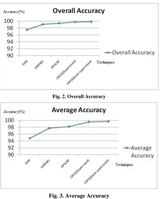
These are the graphical representation of Overall Accuracy and Average Accuracy. Different previous
techniques are shown such as SVM, SVRFMC, DPSCRF, CRFSS (Supervised) and the technique which is
implemented in this paper is CRFSS (Semi-supervised). This is the graph of Overall accuracy, here by the
comparison of all previous techniques CRFSS (Semi-supervised) algorithm has the highest overall accuracy.
417 | P a g e
Fig. 2. Overall Accuracy
Fig. 3. Average Accuracy
This is the graph of Average accuracy, here by the comparison of all previous techniques CRFSS
(Semi-supervised) algorithm has the highest average accuracy. CRFSS (Supervised) and CRFSS (Semi-(Semi-supervised)
algorithms has very less difference in accuracies.
VI. CONCLUSION
In this paper, the process is to integrate spectral cues, spatial contextual cues and spatial location cues of high
resolution images using conditional random fields (CRFSS). Each cues has it’s different focus and provide
complementary information of pixel label about land cover classes. It improve the classification of spectral
variability with the help of unified probabilistic CRF framework. Probabilistic CRF framework contains
different potentials like unary, pair-wise and higher order potentials, each potential has different focus and
perspective. So, it leads to improve the misclassification occur because of spectral variability. With these three
418 | P a g e
VII. ACKNOWLEDGMENT
I would like to express gratefulness to P.G Dept. of Com- puter Engineering,GESs R.H. Sapat C.O.E.M.S and
R, Nashik.
REFERENCES
[1] Ji Zhao, Yanfei Zhong, Hong Shu, and Liangpei Zhang, High-Resolution Image Classification Integrating Spectral-Spatial-Location Cues by Conditional Random Fields, IEEE transactions on image processing, Vol. 25, No. 9, September 2016 pp 4033- 4045.
[2] Mathieu Fauvel, Yuliya Tarabalka, Jon Atli Benediktsson, Jocelyn Chanussot and James C. Tilton,
Advances in Spectral Spatial Classification of Hyper-spectral Images, Proceedings of the IEEE, Vol. 101, No. 3, March 2013 pp 652-675.
[3] Gabriele Moser, Sebastiano B. Serpico and Jon Atli Benediktsson, Land- Cover Mapping by Markov Modeling of Spatial Contextual Information in Very-High-Resolution Remote Sensing Images, Proceedings of the IEEE, Vol. 101, No. 3, March 2013 pp 631-651.
[4] Stuart Geman and Donald Geman , Stochastic Relaxation, Gibbs Distri- butions, and the Bayesian Restoration of Images, IEEE transactions on pattern analysis and machine intelligence, Vol. Pami-6, No. 6, November 1984 pp 721-741.
[5] Farid Melgani and Lorenzo Bruzzone , Classification of Hyper-spectral Remote Sensing Images With Support Vector Machines, IEEE transactions on geoscience and remote sensing, Vol. 42, No. 8, August 2004 pp 1778-1790.
[6] Richard Szeliski, Ramin Zabih, Daniel Scharstein, Olga Veksler, Vladimir Kolmogorov, Aseem Agarwala,
Marshall Tappen and Carsten Rother, A Comparative Study of Energy Minimization Methods for Markov Random Fields with Smoothness-Based Priors, IEEE transactions on pattern analysis and machine intelligence,Vol. 30, No. 6, June 2008 pp 1068-1080.”
[7] Ping Zhong and Runsheng Wang, Learning Conditional Random Fields for Classification of Hyper-spectral
Images, IEEE transactions on image processing, Vol. 19, No. 7, July 2010 pp 1890-1907.
[8] C Yuliya Tarabalka, Mathieu Fauvel, Jocelyn Chanussot and Jn Atli Benediktsson, SVM- and MRF-Based
Method for Accurate Classificafition of Hyper-spectral Images, IEEE geo-science and remote sensing
letters,Vol. 7, No. 4, October 2010 pp 736-740.
[9] Ping Zhong and Runsheng Wang, Modeling and Classifying Hyper spectral Imagery by CRFs With Sparse
Higher Order Potentials, IEEE transactions on geo-science and remote sensing , Vol. 49, No. 2, February 2011 pp 688-705.
[10] Guangyun Zhang,Xiuping Jia, Simplified Conditional Random Fields With Class Boundary Constraint for
Spectral-Spatial Base-Remote Sensing Image Classification , IEEE geo-science and remote sensing letters, Vol. 9, No. 5, September 2012 pp 856-860.
[11] Konrad Schindler , An Overview and Comparison of Smooth Labeling Methods for Land-Cover
Classification, IEEE transactions on geo-science and remote sensing ,Vol. 50, No. 11, November 2012 pp
419 | P a g e
[12] Yanfei Zhong, Xuemei Lin and Liangpei Zhang, A Support Vector Conditional Random Fields Classifier
With a Mahalanobis Distance Boundary Constraint for High Spatial Resolution Remote Sensing Imagery, IEEE journal of selected topics in applied earth observations and remote sensing ,Vol. 7, No. 4, Apil 2014 pp 1314-1330.
[13] Ji Zhao, Yanfei Zhong,Liangpei Zhang , Detail-Preserving Smoothing Classifier Based on Conditional Random Fields for High Spatial Resolution Remote Sensing Imagery, IEEE transactions on geo-science and remote sensing, Vol. 53, No. 5, May 2015 pp 2440-2452.
[14] Komal V. Rayate, Shyamrao V. Gumaste ,” Image Classification- Review”, International Journal of
Advanced Research in Computer Engineering Technology (IJARCET) Volume 5, Issue 10, October 2016 pp 2544-2547.
AUTHOR PROFILE
Komal V. Rayate is persuing her Masters Degree in Computer Engineering from GESs R. H. Sapat College of
Engineering Management Studies Research ,Nashik. She received her Bachelors Degree in Computer
Engineering from Late G. N. Sapkal College of Engineering, Anjaneri, Nashik in 2015.
Dr. Shyamrao V. Gumaste Completed graduation (B.E.) in Computer Science Engineering from Karnataka
Univer- sity, Dharwar in 1992, Post graduation in CSE from Sant Gadge Baba Amravati University Amravati in
2007. Ph.D. from Sant Gadge Baba Amravati University in 2015. Had 23 Years of Teaching Experience.