B.G. McFADGEN 145
Science & Research Directorate, Department of Conservation, P.O. Box 10-420, Wellington, New Zealand.
LATE HOLOCENE DEPOSITIONAL EPISODES IN COASTAL
NEW ZEALAND
Summary: During the Late Holocene (1800 years BP to the present day) there have been three depositional episodes in coastal sand dune areas: Tamatean (1800 to 450 years BP), Ohuan (450 to 150 years BP) and Hoatan (150 years BP to the present day). Each episode comprised two phases: an unstable phase with a high rate of deposition, followed by a stable phase with a low rate of deposition and soil formation.
For the last 1000 years sand dune areas have been favoured places for human settlement. Despite a growing population, unstable dunes have twice become stable. Soils formed on them at the same times as on river alluvium. During that 1000 years, three quarters of the forest cover was progressively cleared by burning, but there was no apparent correlation with increased instability in sand dune areas. The depositional episodes are therefore considered to be independent of human influence. Their principal cause appears to be climatic, with unstable phases being windy and dry and stable phases less windy and moist.
Keywords: Holocene; depositional episode; forest clearance; erosion; Taupo pumice; Loisels pumice; climatic fluctuations; sand dunes; soil stratigraphy; archaeology.
Introduction
When humans first arrived in New Zealand about 1000 years ago, the landscape was nearly all covered in forest. Major exceptions were the alpine areas and some Central Otago basins (McGlone, 1983) which were too dry; and some coastal areas, which were composed of unstable moving sand. To settle the country, the first Polynesians had to clear the forest. As their numbers increased, so more and more forest was cleared to provide space for settlements, to keep tracks open, and to procure food. In the 800 or so years between Polynesian arrival and European settlement, some 50% of the forest was cleared, and in the following 100 or so years a further 25% was cleared (Wendelken, 1976).
Erosion is generally considered to follow forest clearance. The Polynesians burnt the forest throughout the prehistoric period, so it is rather surprising to find that some 400 years after first settlement, the active coastal sand dunes stabilised, and the soil which formed on them was colonised by forest. In some places that soil is still the present day "ground soil" (Ruhe, 1969), but elsewhere it has been buried by more recent sand. The soil formed on sand accumulated during the Tamatean Depositional Episode, the first of three episodes recognised in late Holocene deposits between Auckland and Dunedin (McFadgen, 1985) (Fig. 1). The next oldest is called the Ohuan, and the youngest, the Hoatan. All three are recognised in dune sand, and other coastal deposits including alluvium. This paper briefly discusses the episodes and their possible cause based on McFadgen (1985).
Figure 1: Locations of late Holocene deposits where depositional episodes are recognised.
Depositional Episodes
Each episode consisted of two phases: an unstable phase with a high rate of sediment deposition followed by a stable phase when the rate of sediment deposition was low and soil formed. Tamatean, Ohuan, and Hoatan deposits are present at all localities shown in Fig. 1, except that Hoatan deposits have not been recognised separately in alluvium along the Rakaia or Waimakariri rivers. Tamatean soil is present at all localities, but Ohuan soil has not yet been recognised on the west Auckland coast. Hoatan soil is poorly formed and in places, non-existent.
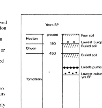
An idealised section through the deposits is shown in Fig. 2. Statigraphic boundaries of the episodes are the tops of the two buried soils. The two pumices are sea-rafted deposits. Taupo pumice occurs in deposits on both sides of the North Island, and in the northern South Island. Loisels pumice occurs only on the eastern side of the North Island and on the western side at the extreme north. Because they occur widely they are invaluable for correlation. Taupo pumice erupted ca 1800 years ago and is part of the Taupo Pumice Formation (Healy et al., 1964). Loisels pumice (Wellman, 1962) erupted c. 650 years ago (McFadgen, 1982) from an unknown source, possibly outside New Zealand.
The statigraphic relationship between the buried soils and the two pumice layers extends over almost the whole length of the North Island east coast south of Auckland. It is the best evidence that the soils all formed at the same time on coastal deposits around the North Island and northern South Island. On the South Island east coast the buried soils are correlated using radiocarbon dates (McFadgen, 1985).
Dates for the depositional episodes are based on radiocarbon and, for the Hoatan, on historic dates and European artifacts. Adopted dates for the events are (McFadgen, 1985):
Stratigraphic Event Years BP
Ohuan soil buried 150
Ohuan soil begins to form 400
Tamatean soil buried 450
Tamatean soil begins to form 600 Loisels pumice deposited 650 Taupo pumice deposited 1800
Because of the vagaries of radiocarbon dating, the dates for the Loisels pumice and for the formation and burial of the Tamatean soil could be in error by up to 100 years, and dates for the two youngest events by somewhat less.
Figure 2: Idealised section through late Holocene deposits showing the two buried soils, the ground soil, and the Taupo and Loisels pumices. Inferred ages in calendar years ago.
Tamatean Depositional Episode
The Tamatean unstable phase lasted for some 1200 years and humans arrived about 400 years before it ended.Rare angular charcoal fragments are usually found a few centimetres below other definite cultural remains such as middens, and often just below Loisels pumice. Their angular shape and higher position in the sections distinguishes them from the rounded water-deposited charcoal from the Taupo Pumice eruption. Some of the fragments may be from natural fires, but their stratigraphic proximity to cultural remains makes it more likely they are from fires lit by humans to clear coastal vegetation for settlement. They are considered to mark the earliest evidence of human occupation.
McFADGEN: HOLOCENE COASTAL DEPOSITS 147
Tamatean soil began forming about 600 years ago. Buried soils have not yet been recognised within Tamatean dune deposits, (which appear to have accumulated uninterruptedly for some 1200 years), but deposition was interrupted by soil formation in alluvial deposits of corresponding age (Grant, 1985).
After the Tamatean soil began forming, the coastal sand dunes remained stable for about 150 years and were colonised by forest. Since they were close to the sea, an important source of food, they were favoured places for Polynesians to live; and being covered with forest they were probably very sheltered.
Ohuan Depositional Episode
After about 150 years of soil formation, the coastal sand dunes entered the Ohuan unstable phase. In some places, older dunes became unstable, but much of the sand that formed the new dunes appears to have come from the sea. Within about 50 years, parts of the former stable dune surface were overwhelmed by new sand which buried the forest and many of the places where the Polynesians had lived. This phase was a time of substantial change in some coastal environments, although not all changes were a direct result of the depositional episode (McFadgen, 1985). At an archaeological site at Foxton in the Manawatu the water table rose about 105m, apparently coinciding with an advance inland of Ohuan sand dunes. On the southeast Wairarapa coast, the coastal platform, which, during the Tamatean had forest trees and lagoons on it, was transformed by fire, earthquake, marine erosion and alluvial deposition, into the barren, windswept place that it is today.
In the South Island, it is Ohuan sand which forms the present barrier between the Avon-Heathcote estuary and the sea. At Long Beach near Dunedin, the coast built seawards nearly 0.5 km. The Ohuan sand at Long Beach differs from the Tamatean sand in that it has more quartz and a lower concentration of heavy minerals in it. This quartz sand is widespread along the Otago coast. It is similar to sand from the Clutha River, which drains the Central Otago basins, rather than to locally-derived sand from erosion of the volcanic hills near Dunedin.
The Ohuan soil began forming about 400 years ago and unlike the earlier Tamatean soil it apears to have been colonised by scrub rather than forest. In sand dune areas at this time the forest edge would have been well inland from the coast. The soil was lived on by the Polynesians and was the ground soil at the time of European contact.
Hoatan Depositional Episode
The Hoatan unstable phase began shortly after Europeans arrived and still continues. After European contact the Maoris had steel axes and began to grow "Irish" potatoes. The rate at which they cleared forest in the late 18th and early 19th century increased, and Cameron (1964) estimated that it almost equalled the maximum rate perpetrated later by Europeans. From mid 18th century onwards Europeans cleared a further quarter of the original forest cover. Despite the combined efforts of Maori and European at clearing forest, deposition during the Hoatan unstable phase has been far less than in the earlier episodes. It is significant that there has been very little deposition along the lower Rakaia and Selwyn rivers, despite the supposedly "severe" erosion in the South Island since European settlement.Cause of Depositional Episodes
The episodes appear to be unrelated to sea level changes, earthquakes or volcanic eruptions.Stratigraphic correlation between the episodes in dune sand and in coastal stream and river alluvium suggests that the episodes are related to changes in erosion rates in river systems. Unstable phases occurred when erosion rates were high, stable phases when rates were low (McFadgen, 1985).
The erosion does not appear to be related to forest clearance. When Polynesians discovered New Zealand nearly all of the landscape was forested yet the coastal dunes were unstable. The Polynesians progressively burnt the forest from the time they arrived until after European settlement. Although that burning might be expected to perpetuate instability, deposition since human arrival was punctuated by periods of stability and soil formation. Indeed, during the period when forest was being cleared, the rate of deposition actually slowed down or stayed about the same (Fig. 3).
Figure 3: Average rates of deposition since the Loisels pumice determined from 16 sections through a variety of sedimentary deposits along the east coast of the North Island. All deposition is assumed to have occurred during unstable phases. Rates are expressed as a proportion of the rate for the Hoatan unstable phase (= 1).
a = rates using adopted ages for Loisels pumice, the end of the Tamatean unstable phase, and the start and end of the Ohuan unstable phase.
b = rates assuming a maximum error of + 100 years for the adopted age of the Loisels pumice, and -100 years for the other adopted ages.
of alluvial sedimentation have been separated by tranquil (soil forming) intervals over the last 1800 years.
The depositional episodes for sand, and the periods of alluvial sedimentation generally coincide. However, fewer stable phases have been found in the coastal deposits than tranquil intervals in the river deposits. It could be that because coastal dunes are fragile and susceptible to wind erosion their soils may not have survived. Alternatively, conditions leading to soil formation on alluvium may not necessarily result in soil formation on coastal dunes. Nevertheless, agreement is good between the Tamatean and Ohuan stable phases and the tranquil intervals represented by soils 4 and 5 of Grant (1985). The relative magnitudes of alluvial sedimentation derived by Grant for each period decrease towards the present time. Again, this is contrary to expectation if erosion and sedimentation are related to humans clearing the forests.
The depositional episodes are thought to be related to changes in climate (McFadgen, 1985; Grant, 1985), and most particularly to the frequency of tropical and extra-tropical cyclones (Grant, 1981, 1983). There is a rough correlation, which might be
improved by better dating, between the depositional episodes and temperatures for the last 1000 years indicated by oxygen isotope measurements of stalagmites (Wilson et al., 1979) and _Cl3 variations in New Zealand Kauri trees (Grinsted and Wilson, 1979). Unstable and stable phases appear to correlate with times of warmer and cooler temperatures respectively. There is reason to suspect that there are more tropical storms in warm than cool periods (Lamb, 1972; Grant, 1983). Such storms cause widespread flooding and severe forest damage, bringing down many slips and greatly increasing the transport of sediments in rivers (eg Barnett, 1938; Tomlinson, 1975; Grant, 1983; Grant et al., 1978).
During the Tamatean stable phase, forest vegetation colonised formerly unstable sand in the Manawatu and on the Wairarapa coast. During unstable phases the climate would have been unfavourable for soils and vegetation to establish on coastal dunes, but more favourable during stable phases. Unstable phases are thus correlated with warm, windy and dry conditions and frequent tropical cyclonic storms, and stable phases with cooler, calmer and wetter conditions and fewer tropical storms.
References
Barnett, M.A.F. 1938. The cyclonic storms in northern New Zealand on the 2nd February and the 26th March, 1936. New Zealand Department of Scientific and Industrial Research,
Meteorological Office Note No. 22.
Cameron, R.J. 1964. Destruction of the
indigenous forests for Maori agriculture during the nineteenth century. New Zealand Journal of Forestry 9: 98-109.
Cowie, J.D. 1963. Dune-building Phases in the Manawatu District, New Zealand. New Zealand Journal of Geology and Geophysics 6: 268-280. Grant, P.J. 1981. Recently increased tropical cyclone activity and inferences concerning coastal erosion and inland hydrological regimes in New Zealand and eastern Australia. Climatic Change 3: 317-332.
Grant, P.J. 1983. Recently increased erosion and sediment transport rates in the upper Waipawa river basin, Ruahine Range, New Zealand. Soil
Conservation Centre Aokautere Publication No. 5.
McFADGEN: HOLOCENE COASTAL DEPOSITS
149
Grant, P.J.; Hawkins, N.V.; Christie, W. 1978. Rainfall and floods of cyclone Alison March 1975 on the north-eastern Ruahine Range. Water and Soil Miscellaneous Publication No.1.
Grinsted, M.J.; Wilson, A.T. 1979. Variations of 13C/12C ratio in cellulose of Agathis australis
(kauri) and climatic change in New Zealand during the last millenium. New Zealand Journal of Science 22: 55-61.
Healy, J.; Vucetich, C.G.; Pullar, W.A. 1964. Stratigraphy and chronology of Late Quaternary volcanic ash in Taupo, Rotorua, and Gisborne Districts. New Zealand Geological Survey Bulletin n.s.73
Lamb, H.H. 1972. Climate: Present, Past and Future, Volume 1: Fundamentals and Climate Now.
Methuen, London.
McFadgen, B.G. 1982. Dating New Zealand archaeology by radiocarbon. New Zealand Journal of Science 25: 379-392
McFadgen, B.G. 1985. Late Holocene stratigraphy of coastal deposits between Auckland and Dunedin, New Zealand. Journal of the Royal Society of New Zealand 15: 27-65.
McGlone, M.S. 1983. Polynesian deforestation of New Zealand: a preliminary synthesis.
Archaeology in Oceania 18: 11-25.
Pullar, W.A.; Penhale, H.R. 1970. Periods of recent infilling of the Gisborne plains basin. New Zealand Journal of Science 13: 410-434. Ruhe, R.V. 1969. Application of Pedology to
Quaternary Research. In: S. Pawluk (Editor):
Pedology and Quaternary Research. Symposium held at Edmonton, Alberta, May 13 and 14th 1969, University of Alberta.
Tomlinson, A.I. 1975. Cyclone Alison. New Zealand Meteorological Service, Technical Information Circular No. 148.
Wellman, H.W. 1962. Holocene of the North Island of New Zealand: a coastal reconnaissance.
Transactions of the Royal Society of New Zealand Geology 1: 29-99.