e-ISSN: 2278-7461, p-ISSN: 2319-6491
Volume 7, Issue 5 [May 2018] PP: 66-70
A Model for Rural Road Network Development in Hilly Regions
of Nepal
Jagat Kumar Shrestha
11Department of Civil Engineering, Pulchowk Campus, Institute of Engineering, TU, Nepal
Corresponding Author: Jagat Kumar Shrestha
Abstract:
Access to goods and public facilities in rural areas of developing countries like Nepal is a problem due to the absence or poor condition of road links. An appropriate road network for the areas can be planned to address the problem. However, only some links can be developed at the same time, due to resource constraints. Hence, proper decisions about which links should be developed or constructed to achieve the maximum connectivity to the rural settlements and public facilities are needed. This paper presents a decision model for a rural road network that provides portfolio of suggested links for road network development and offers solutions for different budget levels maximizing connectivity in the rural road network. Mixed integer programming is used to get an optimal solution.Keywords:
Optimization; rural road network; minimum spanning tree; backbone and branch network; prioritization--- --- Date of Submission: 25-05-2018 Date of acceptance: 09-06-2018 ---
---I INTRODUCTION
Nepal has population of 28 million and the majority of the population (43%) lives in hilly regions of rural areas. Many residents of the rural settlements are not integrated in the national road network due to the absence or poor road connectivity. The public facilities for the residents are also scattered in different settlements in the hills. It is therefore difficult to get to public services and participate in economic and social activities because of the poor road connectivity. This has affected the quality of life in the hilly regions of rural areas.
Only around 30% of Nepal is accessible by roads. More than 39% percent of the population in the hills is out of reach to all season roads within 4-hours walk [1]. The road network is mostly developed in the plains regions of the country. Hence, there is a need to extend and develop these roads particularly in the hilly regions of Nepal in order to integrate the rural facilities and the rural residents in the national network.
The location of facilities, in order to serve residents, is constrained by the structure of the road network. When the network is designed improperly, residents get poor service even when facilities are located optimally. There is significant interaction of the network with facility locations [2] [3]. Hence, the location of settlements and public facilities has to be considered in design of rural road network so that the access to the public facilities will be improved.
In developing countries, funds available for infrastructure development are always a constraint. Apart from limited financial constraints to build rural roads and public facilities, the lack of proper planning methodology of these rural infrastructures is also a major problem [4]. The models developed for the urban areas may not be suitable for the rural areas. Hence, a suitable method of planning rural road networks is necessary that would assist decision makers on how to make an effective choice under limited fund constraints [2] considering rural settlements and public facility (e.g. health centers, schools, and rural markets) locations.
As the settlements and public facilities are scattered in rural hill areas of Nepal, there is a difficulty to access facilities. Nevertheless, residents should have access to public facilities and services within a reasonable distance [5] [6]. Fixing a service distance can be a political issue, however, 4 km (approximately 1 hour walking distance) in case of hilly region of Nepal. Thus, one or more nodal points within a political boundary that can cover most of the facilities in specified distances can be identified in hilly areas [7] [8]. The delineation of the area can be, for example, the Village Development Committee (VDC) boundaries, which were the lowest political units in Nepal.
network has been identified. The backbone links pass along the main ridges of hills and connect the branch links from the secondary ridges [9]. The backbone links can be connected before connecting any branch links. This helps further simplification of selection criteria of the road links in the road network. Further, the road links can be prioritised based on some economical or social parameters.
This paper proposes a simple rural road network development model for hilly regions of Nepal. The paper is organized as follows. Section II formulates the rural road network decision model. Section III deals with prioritization of rural road links. Section IV presents the model application and validation with solution results. Finally, conclusions are provided in section V.
II PROBLEMFORMULATION
The model can be formulated considering a road network as an undirected graph G = {N, L}. Where, N and L are the sets of nodal points and road links respectively.
The following notations are used. is the weightage to the link (i,j). B is an available investment budget, and is the cost of improving link (i,j). The decision variables in this model are: =1 and =1 if a link (i,j) is to be built, 0 otherwise. m is the greatest node number in the backbone network.
The model can be formed based on Network Design Problem [10] [11] [12]. The proposed model allows investigating the budget allocation in order to attain maximum connection to the nodal points (selection of maximum number of links).
Maximize
(1)
Subject to
(2)
(3)
(4)
(5)
(6)
Equation (2) indicates that the construction expenditure is constrained to an investment budget. Estimation of improvement cost (I) depends on length of link, local conditions and characteristics of road elements (cross drainage structures, geometry of alignment, cross section of road, and pavement structures (earthen, gravel or asphalt). The construction expenditure term includes only one link either (i, j) or (j, i) on which both flows j to i and I to j can appear. Equation (4) ensures that the backbone links are selected before selecting the branch links. Equation (3), (5) and (6) has binary values.
The weight of each road link in network can be calculated considering social and economic indicators. However, for rural areas where the economic indicators cannot be fairly estimated and their significance is less, it can be calculated based on social indicators such as population served by links [7] [13], population served by the link/construction cost of the link [14], and gravity flow model [15]. If the links are not prioritized, the value of weight can be assumed unit in (1).
III PRIORITIZATIONOFRURALROADLINKS
Prioritisation of road links is usually based on economic returns from the road linkages. The traditional feasibility indicators for economic evaluation of highway are Net Present Value (NPV), discounted benefit cost (B/C) ratio, and internal rate of return (IRR). These conventional methods are used for urban, and highways and higher standard roads where the economic return can be fairly estimated.
and rural facilities should be connected or covered for the access to goods and services at least to a minimum level. Hence, a different approach is necessary to prioritise the road links in a network. In this context, a practical method for prioritizing road links in hilly regions of rural areas of Nepal is required.
One way of solution of the prioritization of the road links in a network problem can be based on social factors. The key social factor in the rural hill area is population covered by a road link. The traffic generations in rural road links are due to population. As the role of other factors may not be significant, calculation of weight based on the population covered by links can be a realistic approach. Population can be considered as a good proxy for traffic in rural areas to measure the benefit from the linkage [14]. This method has been worked out in the following section for calculation of weight of road links. When the traffic data and other data can be collected or is readily available, the weighting of links can be determined accordingly.
IV MODELAPPLICATION
The applicability of the proposed model is tested in the rural road network (81 km) formed in previous 15 VDC of the hilly region in Gorkha district of Nepal as shown in Fig. 1. This is the MST of rural road network in the previous 15 VDCs of the district formed based on the covering based approach [7] and taken as the minimum level of connectivity necessary for the region to provide access to the settlements and public facilities. The node numbering in the network is arranged as shown in Figure 1 so that the backbone link nodes are numbered first. Nodes 1 to 10 lie in the backbone links and the links are highlighted with thick lines.
Based on population served by links, weights of links have been calculated as given in Table I. The weight in the fourth column of the Table I is calculated as a percentage of population served (third column) based on the total population of the region as 63437. The budget required for one kilometre earthen road construction is assumed as NRs 0.5 million (NRs is Nepalese Rupees, 1 Euro ≈ NRs 110).
1 11
2 3
12 4
5
13
14 6
7
15 8
16
17 18 19 9
10 20 22
21
Nodal points
Intermediate points Legend
Main nodes
Backbone links Branch links
Fig.1. Rural road network with backbone and branch links.
TABLE IWEIGHT BASED ON POPULATION SERVED
Links
Length (km)
Population served
Weight
1-2 3.52 58936 92.9
1-11 5.75 4501 7.1
2-3 3.34 51458 81.1
2-12 6.00 7478 11.8
3-4 3.44 48021 75.7
4-5 5.70 43029 67.8
5-6 4.12 33766 53.2
5-13 2.69 9263 14.6
6-7 2.49 31520 49.7
7-8 0.70 27112 42.7
7-15 1.74 4408 7.0
8-9 2.78 18144 28.6
8-16 1.50 8968 14.1
9-10 2.10 12679 20.0
9-19 5.57 5465 8.6
10-20 1.20 10257 16.2
13-14 4.20 5383 8.5
16-17 7.73 4040 6.4
16-18 7.35 4928 7.8
20-21 3.28 7236 11.4
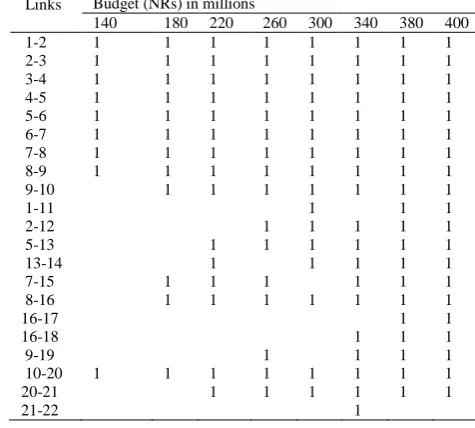
The mathematical model was solved using MPL for Windows 4.2 with CPLEX 10.0’s Mixed Integer Programming solver for different budget levels (Table II).
As the results of the test implementation of the proposed model, the suggested intervention in the network at the different budget level is shown in Table II based on prioritization method of population served by link. The budget level has been started from NRs 140 millions to NRs 400 millions. It can be clearly noted that the models have selected the backbone links first and branch links afterwards. However, for budget level NRs 140 millions; the model selected link 10-20 (1.2 km) rather than selecting backbone link 9-10 (2.1 km) (Table II, Fig. 2). This has happened because the budget is not enough for constructing the link 9-10 but enough for constructing the link 10-20. The decision maker can also put the budget to construct the link 9-10 partially instead of putting the budget in the link 10-20. In this way, as per the availability of the budget, the decision maker can select a set of road links for intervention in the network.
Fig. 2 and Fig. 3 illustrate an optimized network intervention for budget levels NRs 140 million and NRs 300 million respectively.
TABLEIITHE INTERVENTION IN THE NETWORK LINK AT DIFFERENT LEVEL OF BUDGET
Links Budget (NRs) in millions
140 180 220 260 300 340 380 400
1-2 1 1 1 1 1 1 1 1
2-3 1 1 1 1 1 1 1 1
3-4 1 1 1 1 1 1 1 1
4-5 1 1 1 1 1 1 1 1
5-6 1 1 1 1 1 1 1 1
6-7 1 1 1 1 1 1 1 1
7-8 1 1 1 1 1 1 1 1
8-9 1 1 1 1 1 1 1 1
9-10 1 1 1 1 1 1 1
1-11 1 1 1
2-12 1 1 1 1 1
5-13 1 1 1 1 1 1
13-14 1 1 1 1 1
7-15 1 1 1 1 1 1
8-16 1 1 1 1 1 1 1
16-17 1 1
16-18 1 1 1
9-19 1 1 1 1
10-20 1 1 1 1 1 1 1 1
20-21 1 1 1 1 1 1
21-22 1
Note: 1= selected
The implementation of the proposed model in the previous 15 VDCs of Gorkha district shows that it can be a simple and practical decision support tool for rural road network development in the hilly region of Nepal.
21 22
20
19
17 18 16
15
14 13
12
10
9
8 7
6 4
5 11
1 2
3
Nodal points
Intermediate points Legend:
Main nodes
Selected links Links
21 22
20
19
17 18 16
15
14 13
12
10
9
8 7
6 4
5 11
1 2
3
Nodal points Legend:
Main nodes
Selected links Intermediate points
Links
Fig. 3. An optimal network intervention for a budget of NRs 300 million.
V CONCLUSION
Population served by a road link can be a simple and reasonable prioritisation indicator for prioritisation of road links in hilly regions of Nepal.
The proposed model provides a portfolio of suggested links for road network development, and offers solutions for different budget levels, optimizing the number of links that maximise the connections of nodal points in rural areas. The proposed model can be a simple and practical decision support tool for study and development of rural road networks in hilly regions of Nepal.
REFERENCES
[1]. DoLIDAR, Local Infrastructure Development Policy, Ministry of Local Development, Government of Nepal, Kathmandu, 2004..
[2]. M.S. Daskin, and S.H. Owen, Location models in transportation. In Hall, R.W. (eds.), Handbook of Transportation Science. Kluwer
Academic Publishers, Norwell, MA, ch.10, 311-360, 1999.
[3]. S. Melkote, and M.S. Daskin, “An integrated model of facility location and transportation network design,” Transportation Research
Part A, vol. 35, pp. 515-538, 2001.
[4]. S. Heng, Y. Hirobata, and H. Nakanishi, “An integrated model of rural road network design and multi public facility locations in
developing countries,” Conference on Infrastructure Planning Committee, Japan Society of Civil Engineers vol.34, 2006.
[5]. S. Rahman, and D. K. Smith,. “Deployment of rural health facilities in a developing country,” Journal of the Operational Research
Society, vol 50, pp. 892-902, 1999
[6]. S. Rahman, and D. K. Smith, “Use of location-allocation models in health service development planning in developing nations,”
European Journal of Operational Research, vol. 123, pp. 437-452, 2000.
[7]. J. K. Shrestha, A. Benta, R. B. Lopes, N. Lopes, and C. Ferreira, “A numerical model for rural road network optimization in hilly
terrains,” Proc. First ECCOMAS Young Investigators Conference (YIC2012), University of Aveiro, Portugal, 2012.
[8]. R. L. Church, and C. ReVelle, “The maximal covering location problem,” Papers of the Regional Science Association vol. 32, pp.
101-118, 1974.
[9]. J. K. Shrestha, “Linkage pattern of rural roads in hilly regions,” Proc. 15th International Conference of Postgraduates Students, Faculty of Civil Engineering, (JUNIORSTAV 2013), Brno University of Technology, Czech Republic, 2013.
[10]. R. T. Wong, A Survey of Network Design Problems, Operations Research Center, Massachusetts Institute of Technology, 1978.
[11]. S. Heng, Y. Hirobata, and H. Nakanishi, “An Integrated Model of Rural Infrastructure Design in Developing Countries,”
Proceedings of the Eastern Society for Transportation Studies, 2007.
[12]. T. L. Magnanti, and R. T. Wong, “Network Design and Transportation Planning,” Transportation Science. Vol. 18, pp. 1-55, 1984.
[13]. A. Kumar, and H. T. Tilloston, “A planning model for rural roads in India,” Proc., Seminar on roads and road transport in rural
areas, Central Road Research Institute, New Delhi, India, 1985.
[14]. A. Kumar, and P. Kumar, “User friendly model for planning rural road,” Transportation Research Record, vol. 1652, pp. 31-39,
1999.
[15]. R. D. MacKninnon, and M. J. Hudgson, The highway system of South-western Ontario and Quebec: some simple network
generation models. Urban environment study, University of Toronto, 1969.
[16]. T. Airey, and G. Taylor, “Prioritization Procedure for Improvement of Very Low-Volume Roads,” Transportation Research Board
of the National Academies vol. 1652, 1999.