SCALE EFFECTS AND THE DETERMINANTS OF PARCEL SUBDIVISION: A DISCRETE-TIME HAZARD ANALYSIS
Bev Wilson
A dissertation submitted to the faculty of the University of North Carolina at Chapel Hill in partial fulfillment of the requirements for the degree of Doctor of Philosophy in the Department of City and Regional Planning.
Chapel Hill 2009
Approved by:
Dr. Yan Song Dr. Todd BenDor Dr. Emil Malizia
Dr. Daniel Rodríguez
ii © 2009 Bev Wilson
iii ABSTRACT
BEV WILSON: Scale Effects and the Determinants of Parcel Subdivision: A Discrete-Time Hazard Analysis
(Under the direction of Yan Song)
Many of the theories that inform planning analysis and policy-making implicitly acknowledge the importance of space in the form and function of urban areas, but this understanding is highly abstract and in many ways, functions as a black box with limited transparency. This dissertation takes a closer look at the spatial relationships that help to shape urban form and in an effort to move beyond geographic determinism and allow for a more nuanced view of the drivers of residential development patterns. The primary research question asks which factors from existing theory and the literature help to explain the timing and location of land parcel subdivision events. This question is addressed through a combination of qualitative (limited survey) and quantitative (regression analysis) techniques, described in detail in a subsequent chapter.
iv
derive the “priming effect” measure. The present research seeks to link the presence of large residential subdivisions to an elevated rate of residential development in the immediate vicinity. Detection of an effect provides further support for the importance of growth management policy and the influence of residential land developers on the evolution of intra-metropolitan urban form. The results of the study suggest that land availability and prices, demographic factors, accessibility, and the availability of
v
ACKNOWLEDGEMENTS
There are countless people who have helped me during the course of the completing this dissertation. Chief among these is my dissertation chair and academic advisor Dr. Yan Song, without whose guidance and encouragement this undertaking would surely have been much less successful and rewarding. I would also like to thank each of the members of my dissertation committee, Dr. Todd BenDor, Dr. Emil Malizia, Dr. Daniel Rodríguez, Dr. Paul Voss, and Dr. Paul Waddell for their invaluable assistance.
vi
vii
Table of Contents
LIST OF TABLES………..xi
LIST OF FIGURES………..xiii
CHAPTER 1: INTRODUCTION AND OVERVIEW ... 1
1.1 Introduction and Research Questions ... 1
1.2 Research Significance... 5
1.3 Policy Significance ... 6
1.4 Organization... 7
CHAPTER 2: LITERATURE REVIEW ... 9
2.1 Overview... 9
2.2 Land Economics and Bid-Rent Theory... 9
2.3 Evolving Urban Spatial Structure ... 12
2.4 Theories of Decentralization... 14
2.5 The Bigger Picture: Diffusion and Coalescence... 18
2.6 Growth Management Policy ... 20
2.7 Drivers of Land Use Change at the Parcel Level... 22
2.8 A Spatial Perspective for Planning Research... 25
2.9 Summary ... 26
viii
3.1 Overview... 27
3.2 The Engine of Real Estate Markets ... 27
3.3 Developer Behavior ... 29
3.4 A Conceptual Model of Land Subdivision ... 32
3.5 Site Selection Considerations ... 35
3.5.1 Physical Characteristics ... 36
3.5.2 Accessibility... 36
3.5.3 Policy Context... 36
3.5.4 Demographics ... 37
3.6 Land Acquisition... 38
3.7 Conceptualizing Temporal and Spatial Effects... 40
3.8 Summary ... 42
CHAPTER 4: POLICY FRAMEWORK AND ECONOMIC CONDITIONS ... 43
4.1 Overview... 43
4.2 The Study Area: Mecklenburg County, NC ... 44
4.3 The Subdivision Process ... 48
4.4 Local and Regional Growth Management Efforts ... 49
4.5 Economic Conditions... 54
4.6 Summary ... 63
CHAPTER 5: DATA AND METHODOLOGY ... 65
5.1 Overview... 65
5.2 Local Government Data Sources ... 65
ix
5.4 Analysis Components: Linkages and Purpose... 66
5.5 Parcel Change Analysis ... 69
5.6 Point Pattern Analysis... 73
5.7 Developer Survey... 79
5.8 Survival Analysis... 80
5.8.1 Hedonic Regression Analysis ... 92
5.9 Summary ... 101
CHAPTER 6: ANALYSIS AND RESULTS ... 102
6.1 Overview... 102
6.2 Parcel Change Analysis Results... 102
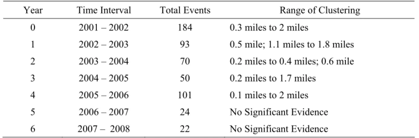
6.3 Point Pattern Analysis Results... 108
6.3.1 Are The Observed Events Clustered Without Regard To Scale? ... 110
6.3.2 Are The Macro-Scale Events Clustered?... 113
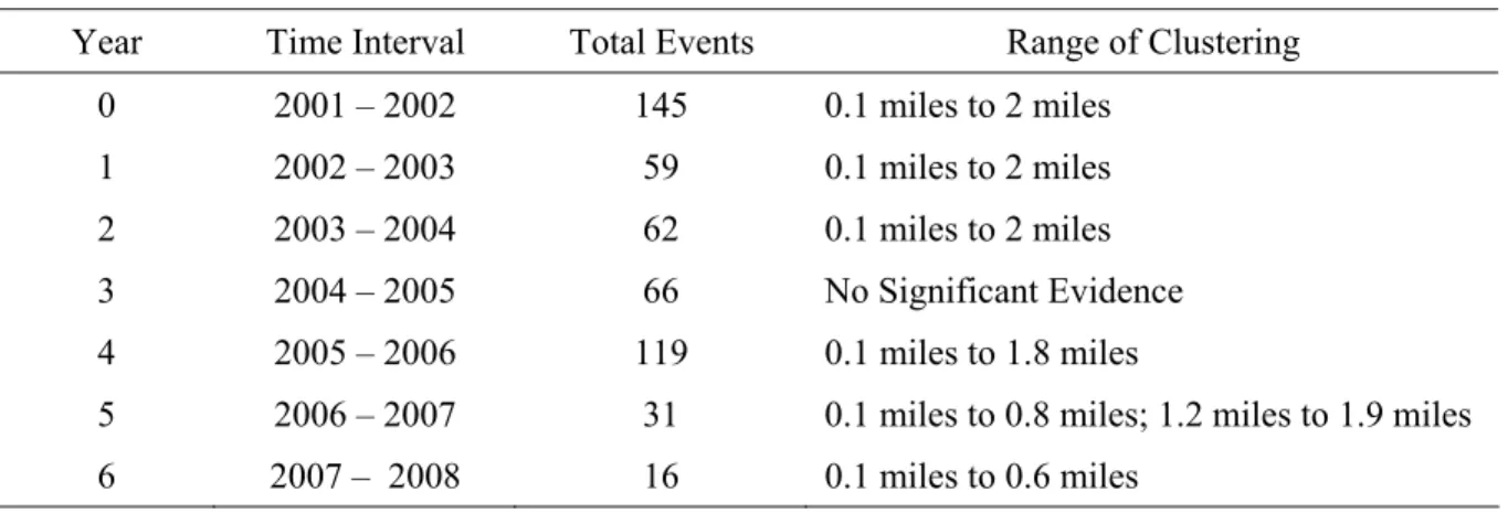
6.3.3 Are The Micro-Scale Events Clustered?... 114
6.3.4 Do The Macro- and Micro-Scale Events Exhibit The Same Pattern? ... 116
6.3.5 Where Is intensity Highest? ... 118
6.4 Developer Survey Results... 120
6.5 Survival Analysis Results ... 125
6.5.1 Hedonic Regression Results: Macro-Scale... 125
6.5.2 Survival Analysis Results: Macro-Scale... 134
6.5.3 Hedonic Regression Results: Micro-Scale... 144
6.5.4 Survival Analysis Results: Micro-Scale ... 154
x
CHAPTER 7: DISCUSSION AND CONCLUSIONS ... 167
7.1 Summary of the Research ... 167
7.2 Theoretical Implications ... 171
7.3 Policy and Practice Implications... 172
7.4 Limitations of the Study... 180
7.5 Future Research ... 182
APPENDIX A... 185
APPENDIX B ... 192
APPENDIX C ... 196
xi List of Tables
Table 1.1: Land Cover/Use By Year With Margins Of Error (Millions Of Acres)... 2
Table 4.1 : Population Change, 1980–2000... 44
Table 4.2: Residential Building Permits Issued (All Jurisdictions)... 62
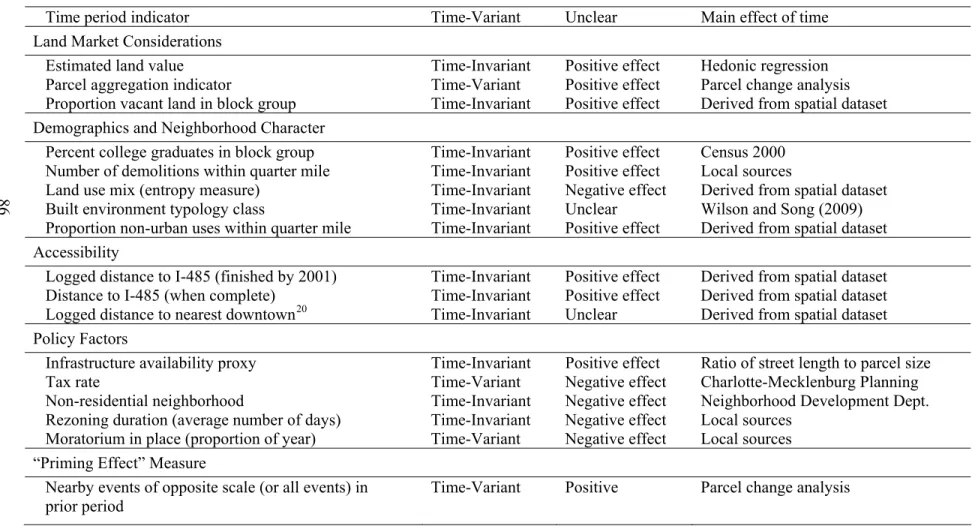
Table 5.1: Hazard Model Independent Variables, Hypothesized Effect, And Source. .... 86
Table 5.2: Independent Variable Description And Hypothesized Effect. ... 93
Table 6.1: Subdivision Events At Macro Scale (N = 1986). ... 104
Table 6.2: Subdivision Events At Micro Scale (N = 4117). ... 105
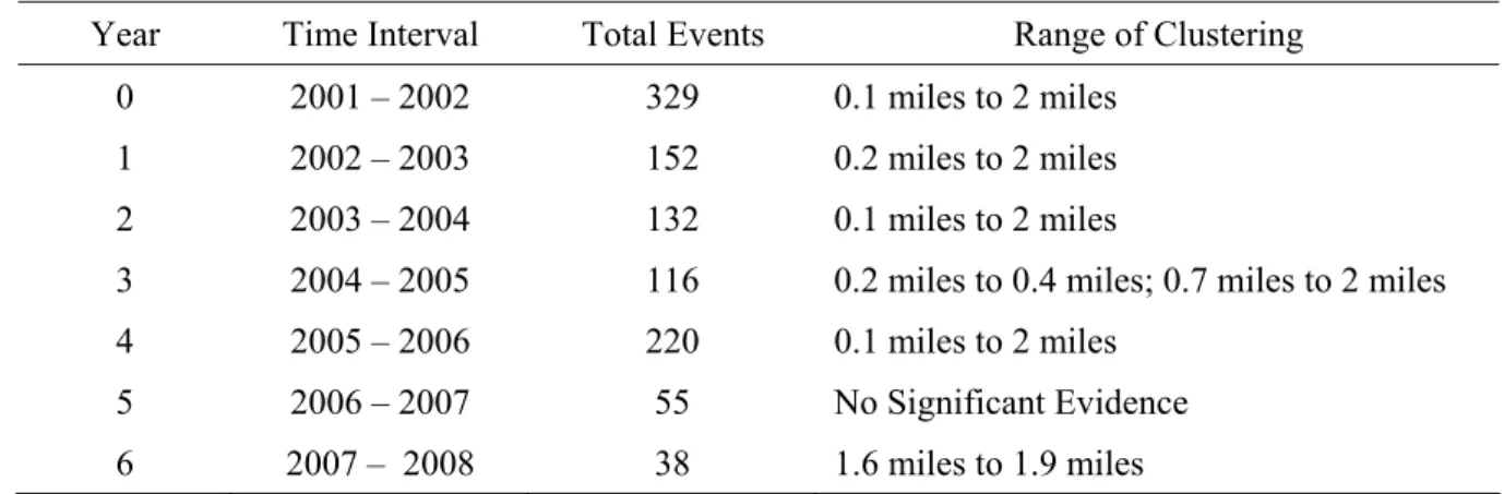
Table 6.3: Inhomogeneous L-Function Analysis Of All Events By Time Period. ... 112
Table 6.4: Inhomogeneous L-Function Analysis Of Macro Events By Time Period... 114
Table 6.5: Inhomogeneous L-Function Analysis Of Micro Events By Time Period... 116
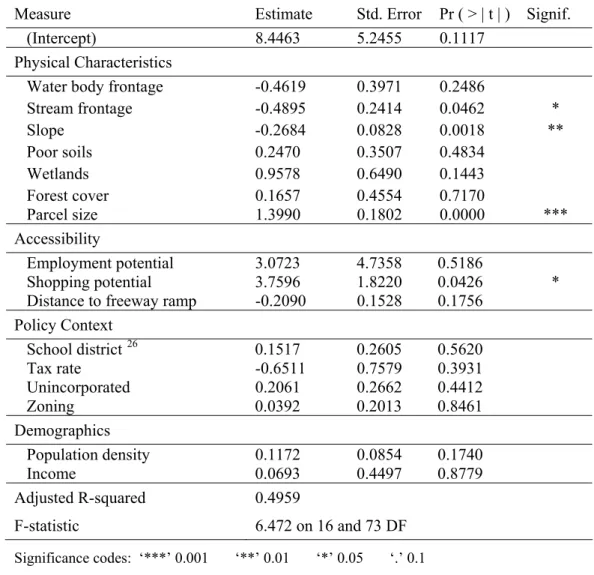
Table 6.6: Macro-Scale OLS Parameter Estimates (N = 90)... 126
Table 6.7: Selection Procedure For Macro-Scale Connectivity Matrices... 132
Table 6.8: Macro-Scale Selection Procedure For Weighting And Coding Schemes ... 133
Table 6.9: Hazard Model Estimates At One-Tenth Mile: Macro Level. ... 135
Table 6.10: Hazard Model Estimates At One-Quarter Mile: Macro Level. ... 137
Table 6.11: Hazard Model Estimates At One-Half Mile: Macro Level. ... 138
Table 6.12: Hazard Model Estimates At One Mile: Macro Level... 139
Table 6.13: Hazard Model Estimates At One Mile: Macro Level, All Events... 142
Table 6.14: Micro-Scale OLS Parameter Estimates (N = 158). ... 146
xii
Table 6.16: Selection Procedure For Micro-Scale Connectivity Matrices. ... 152
Table 6.17: Micro-Scale Selection Procedure For Weighting And Coding Schemes. ... 152
Table 6.18: Hazard Model Estimates At One-Tenth Mile: Micro Level... 155
Table 6.19: Hazard Model Estimates At One-Quarter Mile: Micro Level. ... 157
Table 6.20: Hazard Model Estimates At One-Half Mile: Micro Level. ... 158
Table 6.21: Hazard Model Estimates At One Mile: Micro Level... 159
Table 7.1: Comparison Of Means For Cases And Controls. ... 177
Table A.1: Descriptive Statistics For Hedonic Model: Macro-Scale. ... 186
Table A.2: Descriptive Statistics For Hedonic Model: Micro-Scale. ... 187
Table A.3: Descriptive Statistics For Hazard Model: Macro-Scale. ... 188
Table A.4: Descriptive Statistics For Hazard Model: Micro-Scale. ... 189
Table C.1: Comparison Of Alternate Representations Of Time, Micro-Scale. ... 197
xiii List of Figures
Figure 1.1: Percent Change In Building Permits Issued For Selected MSAs... 3
Figure 3.1: Conceptual Model Of Land Parcel Subdivision... 34
Figure 4.1: Municipal Jurisdictions In Mecklenburg County, 1999... 47
Figure 4.2: Growth Management Timeline. ... 51
Figure 4.3: Monthly Unemployment Rate (Not Seasonally Adjusted)... 55
Figure 4.4: Housing Starts, United States (Seasonally Adjusted): 2001-2008... 57
Figure 4.5: Housing Starts, Southern Region (Seasonally Adjusted): 2001-2008. ... 58
Figure 4.6: Single And Multi-Family Subdivision Approvals: 2000-2007. ... 60
Figure 4.7: Mixed Use And Non-Residential Subdivision Approvals: 2000-2007... 61
Figure 5.1: Components Of The Research Project. ... 68
Figure 5.2: Highland Meadows Parcel Before And After Subdivision. ... 70
Figure 5.3: Spatial Distribution Of Vacant Parcels. ... 72
Figure 6.1: Empirical Baseline Hazard And Survivor Rates: Macro-Scale... 106
Figure 6.2: Empirical Baseline Hazard And Survivor Rates: Micro-Scale. ... 107
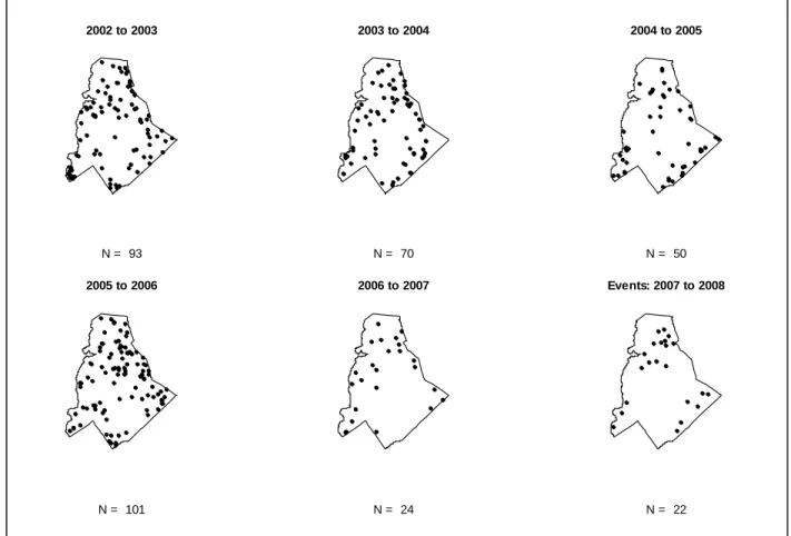
Figure 6.3: Spatial Distribution Of Macro-Scale Events By Time Period. ... 109
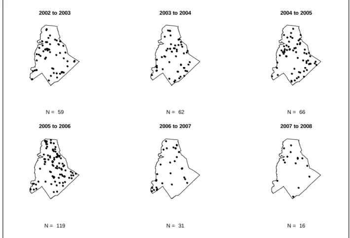
Figure 6.4: Spatial Distribution Of Micro-Scale Events By Time Period. ... 110
Figure 6.5: Inhomogeneous L-Function For All Observed Events... 111
Figure 6.6: Inhomogeneous L-Function For All Macro-Scale Events... 113
Figure 6.7: Inhomogeneous L-Function For All Micro-Scale Events. ... 115
Figure 6.8: Difference Of K-Functions: Macro- And Micro-Scale Events. ... 117
xiv
Figure 6.10: Diagnostic Plots For Macro-Scale Regression... 127
Figure 6.11: Extreme Residual And High Influence, Macro-Scale Model... 128
Figure 6.12: Correlogram Of Logged Sales Price At Macro-Scale. ... 130
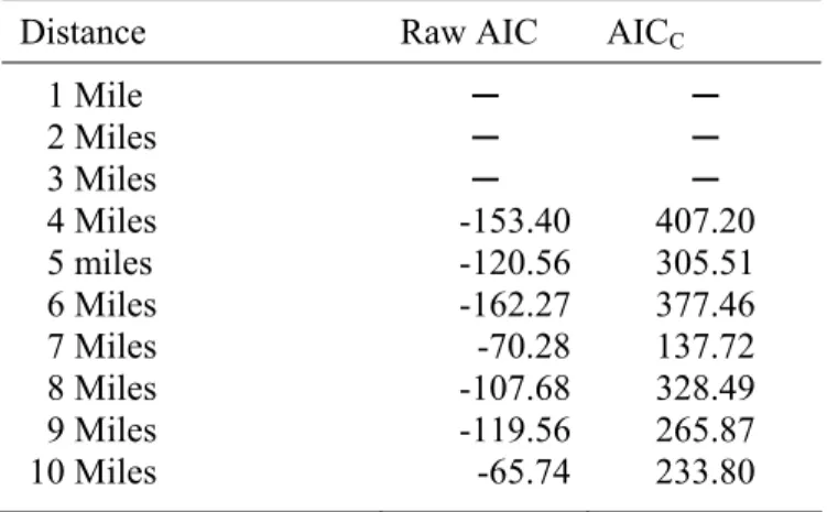
Figure 6.13: Log-Likelihood Of Macro-Scale Model At Various Distance Radii. ... 140
Figure 6.14: Log-Likelihood Of Macro-Scale Models At Various Distance Radii... 143
Figure 6.15: Diagnostic Plots For Micro-Scale Regression... 147
Figure 6.16: Extreme Residual And High Influence, Micro-Scale Model. ... 149
Figure 6.17: Correlogram Of Logged Sales Price At Micro-Scale... 151
Figure 6.18: Log-Likelihood Of Micro-Scale Model At Various Distance Radii... 160
Figure 6.19: Log-Likelihood Of Micro-Scale Models At Various Distance Radii. ... 162
Figure 6.20: Overview Of Hazard Model Results. ... 166
CHAPTER 1: INTRODUCTION AND OVERVIEW
1.1
Introduction and Research Questions
“Location, location, location” is the mantra long associated with the real estate industry, but the importance of spatial relationships also permeates many facets of planning theory and practice. Many of the theories that inform planning analysis and policy-making implicitly acknowledge the importance of space in the form and function of urban areas, but this understanding is highly abstract and in many ways, functions as a black box with limited transparency. This dissertation takes a closer look at the spatial relationships that help to shape urban form and in an effort to move beyond geographic determinism and allow for a more nuanced view of the drivers of residential development patterns. The primary research question asks which factors from existing theory and the literature help to explain the timing and location of land parcel subdivision events. This question is addressed through a
2
Land consumption in the United States is increasing (Table 1.1) and according to the National Resources Inventory 2003 (NRI), the amount of developed land nationwide has steadily increased over the past two decades. This figure rose 18.7% between 1982 and 1992, 12.8% from 1992 to 1997, and 10.8% between 1997 and 2003.
Table 1.1: Land Cover/Use By Year With Margins Of Error (Millions Of Acres).
Land Use 1982 1992 1997 2001 2003
Cropland 419.9 (2.1) 381.3 (2.0) 376.4 (2.0) 369.5 (2.0) 367.9 (2.4) CRP Land 0.0 (N/A) 34 (N/A) 32.7 (N/A) 31.8 (N/A) 31.5 (N/A) Pastureland 131.1 (1.4) 125.2 (1.3) 119.5 (1.2) 119.2 (1.8) 117 (1.8) Rangeland 415.5 (3.5) 406.8 (3.3) 404.9 (3.3) 404.9 (3.4) 405.1 (3.5) Forest Land 402.4 (2.7) 403.6 (2.7) 404.7 (2.7) 404.8 (2.7) 405.6 (2.7) Other Rural Land 48.2 (1.3) 49.4 (1.4) 50.4 (1.4) 50.1 (1.4) 50.2 (1.4) Developed Land 72.9 (0.8) 86.5 (1.0) 97.6 (1.0) 105.2 (1.3) 108.1 (1.4) Water Areas 48.6 (0.1) 49.4 (0.1) 49.9 (0.1) 50.3 (0.2) 50.4 (0.2) Federal Land 399.1 (N/A) 401.5 (N/A) 401.7 (N/A) 401.9 (N/A) 401.9 (N/A)
Source: Natural Resources Conservation Service, 2007.
3
Figure 1.1: Percent Change In Building Permits Issued For Selected MSAs.
state, or metropolitan levels, some insight can be gleaned by considering the number of residential building permits issued. Figure 1.1 shows the percent change in the number of residential building permits1 issued for selected metropolitan statistical areas (MSAs) over the last five years (U.S. Census Bureau, 2008). The building permits data presented above for selected metropolitan areas paints a mixed picture. The larger MSAs shown (Atlanta,
1 Previous years are not included here due to changes in MSA definitions.
2003-04 2004-05 2005-06 2006-07
-40 -20 0 20 40
Washington-Arlington-Alexandria, DC-VA-MD-WV Pittsburgh, PA
Greensboro-High Point, NC
Charlotte-Gastonia-Concord, NC-SC Baltimore-Towson, MD
4
Washington and Baltimore) have experienced the largest downturns, while smaller MSAs (Charlotte, Greensboro, and Pittsburgh) have maintained a relatively strong degree of growth. These trends could potentially be attributed to a variety of factors including growth controls, slowing population growth, larger economic shifts, or the availability of developable land. The impacts of the recent housing crisis and economic collapse are also reflected across the board in the final time period.
Urbanization proceeds as a series of unilateral decisions made by developers, landowners, and other actors within the context of local government planning and
5
individual preferences, property rights, and demand (population driven) for residential and associated land uses.
1.2
Research Significance
Although much has been written on urban sprawl and the growth management programs and policies that have emerged in response to its undesirable consequences, the empirical research has often been conducted at coarse scales with aggregated data. This study embraces recent developments in data collection, storage, and analysis that allow for research at very disaggregate levels by adopting individual land parcels as the primary unit of
analysis. Similarly, there is an abundance of empirical evidence establishing the ongoing trend towards decentralization and movement away from the monocentric past to the
polycentric present and future. However, much of the theoretical basis for land use planning decisions and policy analysis relies upon the increasingly unrealistic assumptions and
constraints of the monocentric model. This study attempts to reconcile these traditional ways of thinking about urban systems with the new realities that are evolving on the ground in urban areas. This involves developing new methods for accommodating multiple
employment and activity centers rather than operating from the assumption of a single exogenously determined central business district. This also requires revisiting our
6
behind modeling larger parcel subdivision events (large, intense land use change) and other parcel-level development (smaller, less intense land use change) separately.
The literature does not lack studies of land parcel conversion and the factors that influence the timing and location of this phenomenon (Irwin and Bockstael, 2002; Bockstael and Irwin, 2003; Carrión-Flores and Irwin, 2004), but our understanding of how large parcel conversions, in particular, affect subsequent residential development patterns requires further research. By understanding the factors that help to explain parcel subdivision events and their capacity to induce further residential development, planners, elected officials, and
researchers can make inroads in terms of managing growth, crafting public policy, and refining our understanding of how urban systems function. Another unique feature of the current research is the use of geoprocessing scripts to perform a change analysis at the parcel level that covers the entire study area. As planning research moves toward more disaggregate units of analysis, automated methods for data manipulation and processing become more essential.
1.3
Policy Significance
7
the urban fringe (Ohls and Pines, 1975; Holcombe, 1999). The proposed research seeks to link the presence of large residential subdivisions to an elevated rate of residential
development in the immediate vicinity. Detection of an effect would provide further evidence for the importance of residential subdivisions and the decisions of residential land developers on the evolution of intra-metropolitan urban form.
In addition to empirical and methodological contributions, this dissertation also provides insight into the site selection and land acquisition processes and behavior of residential developers. To some extent, the residential developers are taste-makers and their decisions frame and influence subsequent residential development patterns (and in many cases infrastructure provision) in a critical manner. Therefore, one of the keys to
understanding what drives urban sprawl and residential development patterns in general, is understanding how developers choose sites and examining the cumulative effects of those decisions (i.e., induced residential development). Our understanding of the urban system is far from complete and empirical research examining the temporal and spatial relationships between parcel subdivision events at a disaggregate (intra-metropolitan) level can contribute to improved planning decisions and policy-making.
1.4
Organization
The next chapter reviews the urban theories that provide the basis for the
conceptual and statistical models, as well as the relevant literature and theory pertaining to the behavior and decision-making processes of residential land developers. A summary of the empirical research related to the conversion of land parcels for residential use and the
8
CHAPTER 2: LITERATURE REVIEW
2.1
Overview
This chapter reviews key literature directly relevant to the current research. The primary research question seeks to identify the factors that influence the timing and location of land parcel subdivision events and prior research in this area is available from a variety of disciplines and at a number of scales. The policy implications of this dissertation lie
primarily within the realm of the growth management and urban sprawl debate and therefore, a summary of important work from this strand of the literature is presented. Chapter 3
focuses on the behavior of the land developer, the site selection process, and land acquisition, so these topics are not treated here. A brief recounting of the classical land economics
tradition that serves as the backdrop for each of the aforementioned discussions is offered as a point of departure.
2.2
Land Economics and Bid-Rent Theory
10
commodity of immediate interest) and a second composite good, which represents all other commodities and services. An individual actor’s (e.g., household, firm) willingness to pay for land is informed by personal preference and available income. Actors compete with one another for land within this larger framework and the each parcel is allocated to the highest bidder (Alonso, 1964: 16). The centerpiece of the land economics and bid-rent theory approach is the tradeoff of land consumption for accessibility, with the rents paid at a given location reflecting the price of its specific level of accessibility to the central business district.
One of the earliest examples of the land economics approach to studying land use change and urban form is the work of von Thünen, who proposed a rudimentary model relating location within a region with a single market to land rent. Several key assumptions underlie this approach: (1) the existence of a single market where all (agricultural) goods are traded, (2) all land is owned by absentee landlords, (3) land is of the same quality, and (4) producers of the same good utilize the same technology and face the same costs of
production (McCann, 2001: 94). The result is a concentric circle configuration characterized by a negative land-rent gradient and intuitively as distance to the center increases,
transportation costs rise and land rents must fall in order to offset this effect (McCann, 2001: 95). Uses that can pay (bid) the highest rents or that have the strongest preferences for a central location (e.g., perishable products) will occupy the land closest to the center.
11
household or firm is allowed to tradeoff transport costs for housing consumption at variable rates, the linear land-rent gradient becomes a curve and the influence of preferences takes on a larger role.
Bid-rent theory has been used to explain the massive move towards suburban development after World War II and continues to inform the way we think about
urbanization and the spatial structure of cities (Carrión-Flores and Irwin, 2004; van der Veen and Otter, 2001). For example, if income rises or transportation costs fall without an
accompanying increase in population, this simplified model predicts decentralization (Alonso, 1964: 142). However, if the influence of rising income and falling transportation costs can be tempered with policy, we might anticipate more compact urban development patterns.
Although most closely associated with households, bid-rent theory can also be used to explain firm location behavior. The firm’s output is a function of the amount of land
12
2.3
Evolving Urban Spatial Structure
The unambiguous and dominant trend in development patterns in practically all metropolitan area of the United States since World War II has been decentralization2(Anas et al., 1998; Glaeser and Kahn, 2001; Wheeler 2008). This term refers to the movement of population (and by extension businesses and municipal services) away from the established city center towards the urban fringe, motivated (at least) in part by public policy. The central business district, which traditionally informed how planners and researchers conceived urban systems, has declined in importance as housing and jobs have shifted away from downtown areas. Although conceptually attractive and not without some degree of explanatory power, the monocentric model (i.e., classical land economics) and its accompanying notions of accessibility-housing tradeoffs are unable to explain the patterns of development increasingly observed across the nation’s urban areas (Heikkila et al., 1989; Bailey, 1999; Filion et al., 1999; Irwin and Bockstael, 2002).
Decentralization is not a new phenomenon; in fact, the first wave of suburbanization began in the early 1900s when the streetcar, and then the automobile, dramatically altered transportation costs for urban households (Anas et al., 1998). While the classic structure of urban areas evolved out of necessity given the limitations and constraints of the industrial era, as these tethers were loosened firms, households, and activities were increasingly free to disperse (Friedmann and Miller, 1965: 316). Manufacturing firms began to move outward following World War II, primarily to take advantage of lower land costs, and a relatively steady outflow of firms and jobs has continued ever since (Anas et al., 1998). Employment
2Urban sprawl is a particular development pattern that falls underneath the umbrella of decentralization, but has
13
decentralization has also been emphasized as a factor shaping urban spatial structure (Carlino 1985; Garreau, 1991; Gordon and Richardson, 1996; Bogart and Ferry, 1999). Over time, accessibility has emerged as a key organizing principle for intra-metropolitan spatial structure and both households and firms react, to some extent, to past location decisions of one another as the relative accessibility and attractiveness of land parcels within a given metropolitan area fluctuate.
There are many factors that contribute to the decentralization trend, which stands as the primary culprit in the erosion of the monocentric model’s credibility. The contribution of highway construction to decentralization is evident from a study of 139 metropolitan
statistical areas (MSAs) between 1950 and 1990 published by Baum-Snow (2007). The data indicate that the construction of highways, originating with the Federal Aid Highway Act of 1944, accounts for “about one-third of the decline in aggregate central city population relative to that in entire metropolitan areas between 1950 and 1990” (Baum-Snow, 2007: 791). During this period, employment decentralization occurred at a faster clip than did residential decentralization and in addition to the influence of improved transportation infrastructure and faster travel times, another potential explanation for this phenomenon is the jobs-follow-people hypothesis (Baum-Snow, 2007). Rising incomes allowed households to consume more land and larger houses, which are typically found on the periphery
14
the metropolitan areas of the United States. Instead, the trend is towards polycentricity, which represents a middle-ground between the bookends of monocentricity and complete dispersion3.
2.4
Theories of Decentralization
A variety of hypotheses have been offered in an attempt to explain the
decentralization phenomenon within the context of land economics and bid-rent theory (Natural Evolution Theory) and also to extend the land economics and bid-rent theory framework to account for other driving forces (Public Choice Theory). Natural Evolution Theory emphasizes changes in transportation technologies and rising incomes as factors that conspire to produce both population and employment decentralization (Mieszkowski and Mills, 1993). On the other hand, Public Choice Theory emerged from the work of Tiebout (1956) and instead focuses on the importance of social and fiscal variables in understanding the location choices of households (Mieszkowski and Mills, 1993). Rather than extending the monocentric model, Tiebout’s work expanded the canon of factors considered when studying residential location decisions, and indirectly, development patterns.
The natural evolution theory of suburbanization is an extension of the classic land economics framework. The basic argument is that the reduction in travel costs associated with highway construction (and subsidies) coupled with the widespread availability of automobiles resulted in the decentralization of residences, followed by firms (Mieszkowski and Mills, 1993). The Natural Evolution Theory combines elements of the Chicago School (e.g., Hoyt’s emphasis on housing filtering; Harris and Ullman’s multi-nucleated model) with
3 Gordon and Richardson (1996) provide an overview of dispersion versus polycentricity as a model of urban
15
the basic notion of the land consumption-transport costs tradeoff. This allowed the familiar framework and conventions of the monocentric city to persist without necessitating a radical rethinking of how urban systems function.
An alternative explanation for the suburbanization phenomenon comes from public choice theory (Mieszkowski and Mills, 1993). Tiebout (1956) argued that households “vote with their feet” in order to maximize their utility and match their preferences for service provision with the levels of service offered by existing jurisdictions. If the assumptions of the model hold (e.g., mobile and knowledgeable households, large choice set, similar cost
structures), then public goods and services are efficiently allocated as jurisdictions compete for residents by tweaking the “market basket” of public goods and services provided. It is the mobility of households that makes the model functional and compelling, but also is the target of some of its harshest critiques. For example, the concentration of poverty in central city areas is often cited as a consequence of Tiebout choice and municipal fragmentation when mobility constraints prevent all households from “voting with their feet” (Downs, 1999). There are indeed many candidate explanations for decentralization (municipal fragmentation, consumer preferences for low-density, flight from blight, provision of public infrastructure, government subsidies (mortgage, highway), zoning and growth controls, and land
speculation) but each of these factors can also be placed within the larger context of public choice theory articulated above.
16
means to pursue their residential choice preferences (rising incomes, limited regulatory intervention), heterogeneity influences urban spatial structure in complex ways.
“Today, many more households have the means to realise a better fit between the type of household they represent and the character of the residential environment. And if such a fit cannot be realised in their direct environment, a solution further away may be looked for, especially since today many people can afford to travel longer distances” (Musterd and van Zelm, 2001: 692).
The preceding statement extends the classic Tiebout choice concept because households have the power to essentially create subcenters that fit their needs (if they do not already exist) due to increasing income and decreasing importance of proximity to traditional centers.
Residential development plays a critical role in the evolution of urban spatial structure, hence its selection as the focal point of this dissertation research.
17
There is empirical evidence of a trend towards polycentric urban form from several urban areas around the United States including Atlanta (Gong and Wheeler, 2002), Chicago (McMillen and McDonald, 1997), Los Angeles (Heikkila et al., 1989; Giuliano and Small, 1991), and San Francisco (Cervero and Wu, 1998). Ingram (1998) considers development patterns in industrial and countries and concludes that cities around the world exhibit
evidence of a trend towards decentralization of both population and employment. While each of the studies cited above focus on the location of employment, a recent study by Griffith and Wong (2007) use spatial regression to analyze population density in the 20 largest
metropolitan areas in the United States and identify six of these as polycentric in form: Los Angeles, Washington DC, San Francisco, Detroit, Atlanta, and Cleveland.
The preceding discussion focuses on explaining the phenomenon of decentralization and linking it to polycentric urban form, but does little to address its normative implications or establish a rationale for planning intervention. Brueckner (2000) fills this gap by framing urban sprawl as a confluence of market failures including transportation subsidies, under-valuation of open space amenities, inefficient allocation of infrastructure costs, coupled with rising incomes with personal preferences (Tiebout choice). In doing so, the author provides a justification for policy intervention in addition to a series of instruments for addressing these problems. Mills (1981) offers a cautionary admonition and argues that urban development is a dynamic process and that “it does not follow just because a land-use configuration is inefficient at one moment in time, that it is inefficient in the larger scheme of things.” Uncertainty on the part of land owners is hypothesized to result in speculative behavior, which contributes to discontinuous patterns of development. This is the most familiar
18
2002: 32). Mills’ position foreshadows the third and final strand of theory discussed here, namely that urban growth does not necessarily proceed along a smooth trajectory and perhaps, a longer-term view is needed.
2.5
The Bigger Picture: Diffusion and Coalescence
Once the reality of decentralization and polycentricity has been firmly established, a logical next question concerns how to reinterpret existing theory and formulate policy within this new context. The effect of multiple subcenters on commuting, land prices, and
development patterns is an area that has borrowed heavily from the monocentric tradition. One of the earliest approaches to reconciling traditional notions of accessibility and spatial interaction with multiple subcenters involved calculating the familiar negative exponential density function for each subcenter and vertically summing the heights of these surfaces to determine the overall influence (across all subcenters) at a given location (Song, 1992: 5). Other studies have used of gravity-based metrics to accommodate the existence of multiple centers (Helling, 1998; Bailey, 1999; Buliung and Kanaroglou, 2006).
In his book Self-Organizing Economy, Paul Krugman makes several intriguing assertions. The first of these is that firm location behavior is the result of complex
interactions between centripetal (attractive) and centrifugal (repellant) forces which can be understood by reinterpreting central place theory on an intra-metropolitan level. This link to central place theory becomes more interesting in light of empirical results from the Los Angeles area that indicate “a relationship between the number and relative size of
19
spillovers, and inter-industry linkages (supply chain). On the other side of the equation are the centrifugal forces like shared markets (competition) and congestion, which tend to result in scattering or discontinuous firm location choices (Krugman, 1996: 91). Krugman
concludes that the evolution of intra-metropolitan agglomerations is an example of a self-organizing, emergent phenomenon the outcome of which cannot be fully anticipated a priori
because firms make location decisions in response to the decisions of other firms and the urban landscape is constantly in flux (Krugman, 1996: 89). The notion of push and pull factors as drivers of location decisions and contributors to emergent urban form can be generalized to households and land developers.
20
emphasis on the influence that large residential subdivision decisions exert on subsequent residential development decisions.
2.6
Growth Management Policy
In the United States, urbanization proceeds as a series of unilateral decisions made by developers or individual landowners within the context of local government planning and regulation (Bockstael and Irwin, 2003). Land use decisions are also informed by strong individual property rights on one hand and the necessity of efficiently providing supporting facilities and infrastructure on the other and as a result, growth management has emerged as a policy response to the myriad negative impacts (e.g., fiscal, environmental, social,
21
Wu, 1998), with attendant implications for air quality (Stone Jr., 2008) and by extension, climate change (Ewing et al., 2008).
The fiscal implications of urban growth are less clear. Conventional wisdom holds that development is good for the public coffers, but Carruthers and Úlfarsson (2003) studied the effect of urban form on twelve measures of public expenditure: total direct, capital facilities, roadways, other transportation, sewerage, trash collection, housing and community development, police protection, fire protection, parks, education, and libraries. Based on an analysis of 283 metropolitan counties, they found that “the per capita cost of most services declines with density (after controlling for property value) and rises with the spatial extent of urbanized land area,” with the exception of sewer service (Carruthers and Úlfarsson, 2003). The authors then leverage this finding to argue for market-based approaches to growth management.
22
2.7
Drivers of Land Use Change at the Parcel Level
There are several ways of thinking about land use change at the parcel level. From an economic perspective, land use change at the parcel level involves converting a vacant or undeveloped plot to a new use or changing the current use and the decision to convert undeveloped land or to change (intensify) the existing use is influenced by a variety of factors including economic, social, and personal considerations. In urban areas and along the fringe, economic factors have received the most attention, partly due to the lack of measures for the other types of factors.
Zax and Skidmore (1994) use a hazard model to investigate the effect of tax rate changes on the probability of parcel conversion. The objective of their study is to pinpoint specific changes in that precipitate parcel conversion from year-to-year using a sample of 224 parcels in Douglas County, Colorado that were undeveloped in 1986. Key independent variables examined in this study include tax rate, frequency of sale, and change in valuation. Intuitively, we might expect an increase in property taxes to decrease the probability of development. However, there is evidence that when increases in the tax rate are known (anticipated), the effect is an increase in the short-term probability of development (Zax and Skidmore, 1994).
Bockstael (1996) brings together concepts from several disciplines to model the probability of land parcel conversion within the Patuxent watershed in Maryland. The key contribution of this study is the formalization4of the decision (on the part of a land owner) to convert a given parcel from one state (use) to another as a function of the present value of
23
expected returns under the current state, less the costs of converting the parcel now and the expected returns under alternate states minus conversion costs. In this way, familiar statistical approaches like discrete-choice modeling can be applied to study and forecast land use
change at a disaggregate level. The author uses hedonic regression to estimate the value of land parcels under agricultural and residential use as a function of: lot size, distance to city centers, distance to highways, water frontage, zoning designation, land use mix, and political jurisdiction. The results of the hedonic regression analyses are then used as independent variables in a probit model of conversion probability alongside controls for the difficulty and cost of conversion (i.e., soils, slops, sewer availability, estimated clearing costs). This
approach served as a starting point for the present dissertation project, but here drivers of land conversion are extended to include major residential subdivisions, which represent an intense land use change and potentially influence subsequent development patterns.
Carrión-Flores and Irwin (2004) estimate a probit model of land use conversion at the parcel level for Medina County, Ohio. Spatial statistics are used to quantify sprawl at a regional scale, while the basic methodology established by Irwin and Bockstael (2002) is used to model parcel conversion at the local scale. Significant findings include the importance of topographical characteristics (e.g., soils) to conversion probability and the limited range of urban accessibility as a factor in parcel conversion. The authors also adopt a spatial sampling scheme to address potential spatial autocorrelation in the data.
24
zoning and land use regulations among jurisdictions within the county and found that land use regulations have different effects in suburban and rural areas. Specifically, policies regarding the provision of sewer infrastructure had little effect on the rate or location parcel conversion in rural areas.
Changing demographics and local spillover effects are two examples of social factors that conceivably affect land use change at the parcel level. Sheer population growth increases demand for housing and other developed land uses and demographic changes (e.g., influx of young professionals) can impact the types of residential development that are favored (Kim
et al., 2005). An intuitive example might be the general preference for larger lots by families with children or the tendency for retirees to “down-size” to apartments and condominiums. Aside from population increase and demographic shifts, the preferences of households have clear implications for the rate and location of new development. In many rural areas, the proliferation of second homes has been linked to a desire to be near natural amenities and preference for warmer climates (McGranahan, 1999; Irwin and Bockstael, 2001).
25
prior subdivision activity in the vicinity actually stimulates future residential development. Stated differently, Irwin and Bockstael argue that there is evidence of a repellant effect between subdivisions along the urban fringe in the sense that negative externalities (traffic congestion) and a preference for more bucolic surroundings tend to lower the probability of nearby parcels being developed. This assertion is tested and evaluated by the present study. Perhaps the most interesting, but also most difficult to study and measure, factors that drive land use change at the parcel level are personal characteristics specific to the individual land owner. Individual expectations and speculative behavior are prime examples of these difficult to measure factors. Life cycle considerations can also be important in that many land owners rely on land holdings as a source of retirement income and parcels change ownership when the original owners die and leave the property to heirs (Gobster and Rickenbach, 2004). Finally, personal values (non-monetary) and general attachment to an undeveloped tract can also influence whether a parcel becomes developed (Alig et al., 2004). The difficulty of measuring and accounting for factors like these contributes to the difficulty of modeling land use change at a disaggregate level.
2.8
A Spatial Perspective for Planning Research
Fueled by the emergence of geographic information systems (GIS) as a key
26
study economic growth (Wheeler, 2001) and spatial regression models are represented in the planning literature with applications ranging from modeling housing prices (Yu et al., 2007) to the fiscal implications of urban sprawl (Carruthers and Úlfarsson, 2008). As a discipline, planning has always been interested in where phenomena occur and by embracing an
increasingly spatial perspective, this linkage becomes stronger. The present study reflects this spatial perspective by focusing on hypothesized scale effects among land parcel subdivision events and exploring the spatial extent of hypothesized “priming effect.”
2.9
Summary
CHAPTER 3: CONCEPTUAL FRAMEWORK
3.1
Overview
This chapter offers a conceptual framework for understanding and exploring the determinants of land parcel subdivision events, as well as the temporal and spatial
relationships between these events. The importance of land developers within the framework of residential development is explained and key literature on the behavior and decision-making processes of these actors is reviewed. The conceptual framework is based primarily on two strands of literature: land economics and organizational decision-making. The first two sections of this chapter explain the rationale behind focusing on the land developer within the larger context of the dissertation and briefly reviews some of the key literature on organizational decision-making, as relevant to residential development. The next sections present a conceptual model of the land parcel subdivision process and describe how the land economics literature informs both the site selection and land acquisition components. The final section explains how temporal and spatial effects are conceptualized within the context of the current study.
3.2
The Engine of Real Estate Markets
28
location, and character of residential property and housing available (Bourne, 1976; Hepner, 1983; Bookout, 1990). At a very basic level, land developers select sites and implement development plans that they believe will earn a profit, given prevailing trends in local housing markets, employment, and demographics. A series of studies conducted by
researchers at the University of North Carolina at Chapel Hill during the 1960s were some of the earliest to focus on the behavior and decision-making processes of developers (Chapin and Weiss, 1962; Weiss et al., 1966; Kaiser, 1968). According to the first of these studies, some land development projects are “priming actions” while others are “secondary actions,” with the former distinguished by a “structuring”5 and “timing” effect on subsequent
development (Chapin and Weiss, 1962: 2). Priming actions such as the location of industry, commercial uses, or transportation are conceived as facilitating secondary actions like residential location choices. In the present study, this basic idea is extended to include major residential subdivisions, which represent an intense land use change, as having a priming effect on subsequent development patterns.
Related studies by Weiss et al. (1966) and Kaiser (1968) operate from a basic
conception of the land developer development firm as maximizing a profit function subject to budget constraints within the existing regulatory framework. The locational decision (site selection) is thus, explained by the characteristics of each candidate site (physical, locational, and institutional), characteristics of the actors (developers, land owners, and consumers), and contextual (socioeconomic and policy) factors. A key implication of the North Carolina studies (Goldberg, 1974; Leung, 1986) and the current discussion is that although land
developers wield considerable power in determining growth patterns and shaping urban form,
5 The structuring effect refers to the influence on the location and intensity of secondary actions attributable to
29
their ultimate goal is to be responsive to the market and to anticipate the needs and
preferences of the targeted consumers (Weiss et al., 1966: 3). Because land developers are such key figures in the determining residential development patterns and its implications for urban form, it is essential to better understand their behavior and decision-making processes.
3.3
Developer Behavior
Micro-economic theory suggests that producers (and by extension, firms) adhere to a strategy of profit-maximization to inform and guide decision-making. There are several key underlying assumptions that are typically associated with this approach including rationality, perfect information, unlimited computational capacity, no considerations that cannot be quantified (or assigned a monetary value), and no unresolvable conflicts among competing objectives (Herrnstein, 1990). However, this “classical theory of the firm was never intended to be a managerial or administrative theory,” but “was intended to be a theory of markets—to describe the determination or prices and resource allocations by business firms under varying ideal market conditions within a larger general theory value” (Kenney, 1972: 28). These lofty and unrealistic assumptions drew criticism, most notably from Herbert Simon who
30
public perception can then enter into the equation and the threshold for what is considered an acceptable outcome can fluctuate over time.
In an updated version of their original 1963 text, Cyert and March (1992) build upon this basic idea of bounded rationality to articulate a general theory of how firms (a specific type of organization) make decisions. Firms are conceived as goal-oriented and adaptive organizations that pursue satisfactory outcomes given available information and expectations. Land development is first and foremost a business venture, so basic goals for land
development firms are likely to focus on production, sales, profit, and market share (Cyert and March, 1992). Within a given metropolitan area, the cost of inputs such as land, capital, and labor are comparable across firms, so efficiency, adaptability, information, and market savvy are important sources of competitive advantage (Muth, 1989:16). Perhaps the most significant implication of A Behavioural Theory of the Firm for understanding developer behavior is its emphasis on process, which is sets the stage for the conceptual model presented in the following section and the subsequent discussion of two of the most important components of the land parcel subdivision process.
31
patterns through two mechanisms (Barnard and Butcher, 1989: 679). The first holds that land parcels that are most desirable based on their physical and locational characteristics are scattered and therefore, these parcels are developed first regardless of the implications for urban form or service provision. The second hypothesis states that under-valued land parcels are discontinuous in their spatial configuration and are developed more quickly. From a services provision perspective, a more compact and contiguous pattern of development is more efficient and a key implication of the Cyert and March (1992) perspective is that increasing the predictability and transparency of the regulatory process will encourage developers to make decisions that generate greater returns, but also contribute to more efficient land use patterns.
Another consequence of uncertainty and satisficing behavior is a tendency to treat each development project as a discrete entity, rather than as an overall portfolio that includes both current and future projects (Mohamed, 2006). One explanation for this approach is that each project “must unambiguously pay for itself” in order to successfully justify the proposal to lenders or investors (Mohamed, 2006: 33). However, measures designed to reduce
uncertainty and encourage more efficient development patterns may backfire. Mohamed (2006) argues that a more predictable and transparent regulatory process may actually reinforce the satisficing behavior of developers by allowing them to quickly move from one project to the next once the profit target has been met. Also, the perceived costs and
32
3.4
A Conceptual Model of Land Subdivision
Subdivision of a land parcel for residential use is the culmination of a long process that involves many actors and decisions. Chief among these actors is the land developer by virtue of the site selection and land acquisition processes described above. However, the regulatory framework and development review process within each jurisdiction also plays a role. Figure 3.1 provides a graphical representation of the parcel subdivision process6 and reflects the basic relationships between land developers, land owners, and local government.
The starting point for the land subdivision process, as depicted in Figure 3.1, is with a general idea for a development project, informed by the availability of financing, housing demand, and the local regulatory framework. Financing is a key component of successful real estate ventures and the goals of the land developer are generally “to raise the maximum amount of funds at the lowest possible cost and to share as much of the risk as they can with their financial backers” (Bookout, 1990: 101). The goals of investors and lenders are similar in that they each seek the highest possible return, while minimizing their exposure (Corgel et al., 1998: 191). This shared risk-aversion and profit incentive is what links these two actors within the land development system and the ability to harness enough financing is one of the primary factors in whether a proposed project moves past the initial stages (Bookout, 1990).
A successful development project must be marketable, which means that there must be adequate demand for housing of the same type, price range, and character to ensure
acceptable absorption rates. The market analysis is a fundamental component of the
development process and assesses the feasibility of the proposed project, given current and
6 Healey (1991) provides a review of conceptual models of the development process with an emphasis on their
33
expected trends in the demand for and supply of housing in the targeted area (Bookout, 1990: 15). Examples of factors influencing the demand for housing include: household income, population trends, existing housing stock, mortgage conditions, expectations for the future, consumer preferences, and seasonality (Corgel et al., 1998: 276). Experienced developers are able to anticipate changes in housing demand and other market forces to deliver products that meet the needs and match the preferences of their target markets despite the inherent
complexity and uncertainty of the land development process.
The regulatory framework also helps to shape the specific characteristics of a proposed project. Despite attempts to reduce uncertainty and facilitate an orderly development process by streamlining regulatory processes, in many areas government regulations are still deemed an obstacle by developers and chief among these were subdivision ordinances, building codes, and zoning (Ben-Joseph, 2003). These basic land use controls have been around for a long time, but regulatory frameworks are becoming more sophisticated as more local
governments are implementing growth management policies as a means of mitigating the negative consequences of rapid growth. Adequate public facilities ordinances, moratoria, and urban service limits are examples of policy instruments that could potentially impact or negate the feasibility of a candidate parcel for development. These policies are still relatively new and potentially add to the uncertainty of the land development process in jurisdictions in which they are implemented (Pendall, 1999).
Figure 3.1: Conceptual Model Of Land Parcel Subdivision.
NO
Financing Housing
Demand Framework Regulatory
Type, Size, and Character of
Project
Search Criteria
Site Found?
Buy or Option?
NO
YES
Preliminary Plat Proper Zoning?
Rezoning Petition
YES
Initial Administrative
Review
Final Administrative
Review Final Plat
Event
35
project. This search could be contracted out to brokerage firms or conducted in-house using a variety of strategies and techniques including: “windshield surveys,” geographic information systems (Barnett and Okoruwa, 1993), or through established networks and relationships within the industry (e.g., builders, lenders). If no suitable candidates are identified, some characteristics of the planned project may be modified or the idea may be shelved until conditions are more favorable. If a suitable candidate(s) is found, the land owner is contacted and negotiations to option or purchase the land may begin. If these negotiations are
successful, the next step in process may involve submitting a rezoning petition. If the
property is properly zoned, then the subdivision approval process begins with the preparation and submission of a preliminary plat. The preliminary plat typically includes: a formal application, proposed number of units and lot sizes, construction schedule, and site plan (Bookout, 1990: 199). After initial review and approval by local government staff, a final plat is submitted that includes a more detailed site plan and addresses concerns raised during the initial review. Following final review and approval, the plat is recorded and the next phase in the development process begins (construction permits). Arguably, the most important elements of the model presented in Figure 3.1 are the site selection and land acquisition components7 and the following sections treat each of these in greater detail.
3.5
Site Selection Considerations
It is not enough to simply understand the overall psychology of the land development community, it is also necessary to identify the factors that make a site an attractive candidate for residential development. To some extent, site selection considerations or search criteria
7Both are identified as key decisions in residential land conversion process model offered by Weiss et al. (1966)
36
(see Figure 3.1) vary depending on the type and size of the proposed project. However, the same characteristics that make a given location attractive to home-buyers or renters on the demand side, also influence its appeal for land developers on the supply side through enhanced marketability of the finished product (Chapin and Weiss, 1962).
3.5.1 Physical Characteristics
The physical characteristics of a candidate site are important because they influence the market value of the product and the costs of development. An example of physical
characteristics enhancing the attractiveness of a site is adjacency to amenity features like protected open space (Geoghegan, 2002) or waterbodies. On the other hand, the presence of wetlands or steep slopes add complexity and cost to the development process and typically reduce the overall attractiveness of a candidate site (Bookout, 1990: 52).
3.5.2 Accessibility
Bid-rent theory, as articulated by Alonso (1964), asserts that households tradeoff land consumption for accessibility, with the rents paid at a given location reflecting the price of its specific level of accessibility to the central business district. As the traditional assumption of a single centralized employment center becomes less plausible the importance of
accessibility remains, but must be renegotiated. Proximity to destinations including
employment centers, shopping centers, and recreational opportunities are important, but ease of accessing key transportation infrastructure like freeways is also significant.
3.5.3 Policy Context
37
parcel for development. Perhaps the most obvious of these is the zoning designation. If a given site is not already zoned for residential use, a prospective developer will need to navigate the local rezoning process, which can increase the time and cost (fees) involved in bringing a project to market (Goldberg, 1974; Bourne, 1976; Hepner, 1983). The property tax rate (Bayoh et al., 2006) and quality of local schools (Kim et al., 2005; Munroe, 2007) are also important considerations for the site selection process by virtue of their influence on the location choices of households. Finally, the availability of public infrastructure is critical to the attractiveness of candidate sites for residential development (Chapin and Weiss, 1962; Lee, 1979).
3.5.4 Demographics
The demographic and socioeconomic characteristics of the neighborhood or immediate area surrounding a candidate land parcel are also important considerations. Early examples of the importance of socioeconomic factors in understanding residential development patterns is reflected in the work of Chicago School researchers like Burgess (1925) and Hoyt (1939). Hoyt’s sector model emphasizes the role of high income groups in determining residential development patterns. Essentially, new construction occurs in areas deemed attractive to high income groups (e.g., along transport routes, high social prestige) and when these households relocate, existing housing stock filters down the socioeconomic ladder. The supply side focus of the sector model provides a contrast to the earlier concentric zones model, which is
38
of a neighborhood is a more relevant in explaining residential location behavior than many of the more conventional factors.
3.6
Land Acquisition
Land owners represent the other half of the supply-side equation. Intuitively, the decision to sell a currently developed parcel is driven by utility maximization and involves discounting future revenue, given current conditions and uncertainty. Undeveloped parcels may be sold to developers for subdivision, built upon by the owner, sold to local jurisdictions for public uses and facilities, or remain undeveloped. If we assume that land owners (like land developers) are profit-maximizers who seek to minimize uncertainty, an important consideration is speculation and strategic behavior. Capozza and Helsley (1989) formulate a simple model of urban land conversion and derive mathematical relationships between the price of land at the periphery, the time of conversion, and the implications of speculative behavior on larger development patterns (urban sprawl). The authors found that the optimal point for parcel conversion, from the perspective of the landowner, is when the net present value of the parcel is maximized, accounting for agricultural rents, cost of conversion, and discount rates. Carrión-Flores and Irwin (2004) expand upon the Capozza and Helsley model by introducing an interest rate and discounting the expected future benefits (Carrión-Flores and Irwin, 2004: 893).
39
Ulinder, 1976; Barnard and Butcher, 1989). The price of land is also contingent on larger economic conditions with a significant premium associated with favorable expectations about future growth (Guntermann, 1997).
Irwin and Bockstael (2002) hypothesize that the expectations of (undeveloped) landowners are the driving force behind subdivision and by extension, urban sprawl. Here, the basic calculus involves weighing the costs of conversion (infrastructure, administrative fees) and value under current use versus expected value post-conversion (Irwin and
Bockstael, 2002: 39). Conversion costs are a function of topography, infrastructure
availability, administrative fees and the post-conversion value is a function of proximity to employment centers, natural amenities, lot size, and neighborhood characteristics. However, this conceptualization of the decision to sell or retain land breaks down if the land owner is holding the property for non-economic reasons (Kaiser and Weiss, 1970). In situations like this, interpersonal skills and establishing relationships are critical to successfully acquiring targeted properties. A study by Leung (1986) found that large firms were more efficient at implementing projects, but were out-performed by smaller firms in negotiations with land owners. The explanation for this disparity hinged on the observation that “large and nonlocal firms rely more on financial and organizational resources” while “small firms rely more on local connections and knowledge” (Leung, 1986: 31).
40
land at a later date,8 thereby allowing greater flexibility and limiting financial exposure (Bookout, 1990: 105). Loans and joint ventures are examples of common sources for funding purchasing land parcels.
3.7
Conceptualizing Temporal and Spatial Effects
Subdivision of a vacant parcel for development represents an intense, localized
change in land use. As such, these events help to frame and structure the location, timing, and character of subsequent development and there are several reasons why a temporal
relationship should exist between land parcel subdivision events. Given the overall aversion to risk that characterizes the land development process, it is not surprising that proven markets are intuitively appealing to land developers. Further, the establishment of new islands of residential development along the urban fringe or pockets of redevelopment in established neighborhoods are intuitively likely to impact the value and price of land and housing in the immediate vicinity by virtue of simple spillover effects. This is the same basic contagion mechanism that provides the rationale and basis for using Euclidean zoning as a tool for safeguarding home values (Muth, 1989: 25). Finally, large-scale projects can influence the extension of public infrastructure into areas that may or may not have been targeted for development. Depending on the regulatory framework and policies of the given jurisdiction, the developer may have the ability to influence the timing and location of
infrastructure investments. For example, Hanley and Hopkins (2007) found that single family residential development was not limited by sewerage capacity as many developers were able to afford the costs associated with early extension, when this option existed. These are all
8 Developers may also pay the taxes and other costs associated with maintaining the property during the
41
potential explanations for why observing one or more subdivision events in a prior time period might affect the probability of observing events at subsequent time periods. In addition to temporal relationships, this dissertation also explores spatial relationships.
The spatial effects examined here are of two basic varieties: scale effects and the spatial extent of temporal (inducement) effect described above. Intuitively, one would expect the “priming effect” for a larger subdivision event to be larger in magnitude than that of smaller parcels that experience an event. Stated differently, the “variables influencing a process may or may not change with scale, but a shift in the relative importance of variables often occurs” (Turner et al., 1989: 248) and larger subdivisions are expected to exert a greater effect. The point becomes immediately clear, for example, when traffic impacts are considered for a major versus a minor residential subdivision. Although the possible existence of scale effects can be justified through an appeal to intuition, the present study seeks to formally test for empirical evidence. In general, scale effects are expected to be less pronounced than temporal effects, but this assertion is one of the key hypotheses examined by the present study.
42
on this study adopted by applying the sensitivity analysis to a model of land subdivision rather than land sales price.
3.8
Summary
This chapter explains the importance of land developers and their decision-making processes within the context of residential development outcomes and overall urban form. It also provides a conceptual model of the land parcel subdivision process and examines the site selection and land acquisition components in greater detail. Finally, the conceptualization of the temporal and spatial relationships between observed parcel subdivision events is
CHAPTER 4: POLICY FRAMEWORK AND
ECONOMIC CONDITIONS
4.1
Overview
The study area for the dissertation research is Mecklenburg County, North Carolina, which encompasses seven municipal jurisdictions and is roughly 526 square miles in area. Charlotte is by far the largest and most dominant of these entities, but smaller municipalities in the northern and southern portions of the county (see Figure 4.1) are increasingly
44
4.2
The Study Area: Mecklenburg County, NC
Charlotte is the largest of seven municipalities (Cornelius, Davidson, Huntersville, Matthews, Mint Hill, and Pineville) in Mecklenburg County and Table 4.1 shows population9 by municipality and for the county as a whole for the three most recent Decennial Censuses.
Table 4.1 : Population Change, 1980–2000.
Jurisdiction 1980 1990 2000 % Change 80-90 % Change 90-00
Charlotte 314,447 395,934 540,828 25.9 36.6
Davidson 3,241 4,046 7,139 24.8 76.4
Cornelius 1,460 2,581 11,969 76.8 363.7
Huntersville 1,294 3,014 24,960 132.9 728.1
Matthews 1,648 13,651 22,127 728.3 62.1
Mint Hill 7,915 11,567 14,992 46.1 29.6
Pineville 1,525 2,970 3,449 94.8 16.1
Municipal 331,530 433,763 625,464 30.8 44.2
Unincorporated 72,740 77,670 69,990 6.8 -9.9
Mecklenburg County 404,270 511,433 695,454 26.5 36
Charlotte is also the largest city in North Carolina (or South Carolina) and the second largest financial center in the United States (Munroe, 2007: 337). The city has not experienced a tax increase since 1987, which one of the factors that makes it an attractive location for
businesses and households (City of Charlotte, 2000). Traditionally recognized as a textile producing center, Charlotte has experienced a series of corporate relocations that have redefined its identity as a major financial center and stimulated population growth (City of Charlotte, 2000). Charlotte’s central city has experienced many of the problems plaguing