Densifying the Triangle:
Examining How the Region is Planning to Reshape its Future
by
Kyle J. Vangel
A Master’s Project submitted to the faculty of the University of North Carolina at Chapel Hill
in partial fulfillment of the requirements
for the degree of Master of City and Regional Planning in the Department of City and Regional Planning.
Chapel Hill
2012
Table of Contents
Organization ... 6
Overview of the Triangle Region ... 7
The Spatial Structure of the Triangle Region ... 9
Economic, Environmental, and Health Benefits ... 12
Changing Residential Preferences ... 14
Planning Interventions to Increase Density ... 16
The Experience of Planning for Density in the Research Triangle ... 19
Analysis of Goals and Objectives ... 23
Analysis of Policies and Implementation Actions ... 25
Analysis of Community, Special Interest, and Not-for-Profit Participation ... 32
Analysis of Goals and Objectives ... 38
Analysis of Policies and Implementation Actions ... 40
Analysis of Community, Special Interest, and Not-for-Profit Participation ... 45
Abstract ... 4
Introduction ... 5
The Literature on Density ... 12
Methodology ... 21
Raleigh 2030 Comprehensive Plan ... 23
Morrisville Town Center Plan and Morrisville Land Use Plan, 2009-2035 ... 37
Analysis of Goals and Objectives ... 48
Analysis of Policies and Implementation Actions ... 50
Analysis of Community, Special Interest, and Not-for-Profit Participation ... 53
Summary of Findings ... 55
Recommendations for Fostering Higher Density through Planning Processes ... 57
Conclusion ... 55
Reference List ... 60
Abstract
Introduction
The Research Triangle region of North Carolina has long been recognized for its high quality of life and dynamic economy, anchored by leading academic institutions and a number of large corporations. Yet it is also recognized for having a particularly sprawling, low-density
development pattern. As the economic, community health and environmental impacts of urban form become increasingly manifest, the Triangle’s built environment may hinder its economic competitiveness and the health of its population and ecosystem in the future. How well is the Triangle prepared for dealing with this multifaceted issue?
The planning function would seem well-situated to address this issue by fashioning and implementing public policy and development management solutions that foster higher density development. This report seeks to understand the possibilities and constraints of comprehensive planning as a means to foster more compact development forms. It describes how actors
participating in comprehensive planning processes in the Triangle are encouraging more compact development forms, and what policies and implementation measures have been the fruits of their efforts to date. The specific, interrelated questions this report attempts to address include:
To what extent is increasing density a major thrust of recent comprehensive planning processes in the Triangle?
What roles did planners, community members and special interest groups – particularly organizations dedicated to smart growth or economic development – play in
corresponding debates over increasing density?
What tangible impacts, if any, have these planning processes thus far produced on the region’s built form?
In order to address these questions, this report investigates three recent planning processes in the region as case studies. The three planning processes examined are: Raleigh’s 2030
Comprehensive Plan adopted in 2009, Morrisville’s Town Center Plan of 2007 and Land Use Plan, 2009-2035 of 2009, and Research Triangle Park’s soon-to-be completed Master Plan. By examining the planning documents themselves and conducting in-depth interviews with key stakeholders who were involved in these processes, this report offers a robust understanding of how the Triangle is planning for a different future.
To my knowledge, this report serves as the most comprehensive statement to date on how planning processes in the Triangle have wrestled with the issue of fostering higher density development. The report analyzes the goals, objectives, policies, and implementation measures related to increasing density that are advanced by the plans, and how these evolved out of the plan making process. It offers a robust understanding of how public attitudes towards higher density development have influenced recent planning processes. It explains how groups promoting denser development were able to influence the planning and implementation
processes, and what factors limited or enhanced these groups’ effectiveness. Finally, the report describes which development management solutions encouraging higher density development have gained the most favor in the region and why these solutions were favored by planners and the community.
Organization
help the reader to understand the economic, environmental, and health benefits associated with higher densities and the growing market demand for compact development. Building off this section, the bulk of the report consists of in-depth case studies of the aforementioned planning processes in Raleigh, Morrisville, and Research Triangle Park. The methodology of this section is detailed at the outset of this section, and the case studies are presented in turn. Each case study begins with an introduction to the planning area and description of the planning process
undertaken. Next, the planning documents that resulted from these processes are scrutinized for evidence of goals, objectives, policies, and implementation measures that promote increased density. The manner in which community participation shaped the planning processes and outcomes is also discussed. These assessments are strengthened by insights from planners and others involved in these planning processes. In the conclusion, the principal findings of the report are summarized and recommendations for fostering higher density development through
comprehensive planning processes are offered. Overview of the Triangle Region
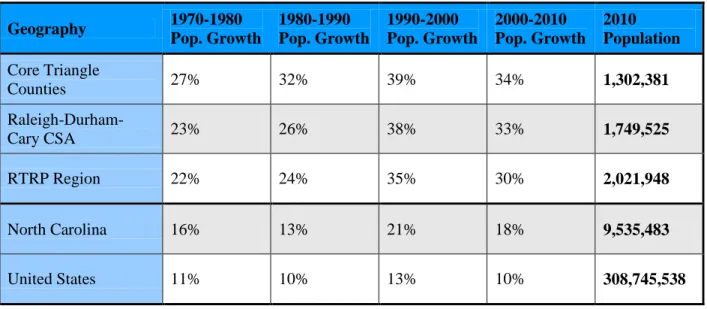
Budget. Under this classification, in addition to Wake, Durham, and Orange counties, the region includes the surrounding counties of Chatham, Franklin, Harnett, Johnson, and Person, for a total of eight counties (Orszag, 2009). The Research Triangle Regional Partnership, a regional
Table 1: Triangle Population Growth
Geography 1970-1980 Pop. Growth 1980-1990 Pop. Growth 1990-2000 Pop. Growth 2000-2010 Pop. Growth 2010 Population Core Triangle
Counties 27% 32% 39% 34% 1,302,381
Raleigh-Durham-Cary CSA 23% 26% 38% 33% 1,749,525
RTRP Region 22% 24% 35% 30% 2,021,948
North Carolina 16% 13% 21% 18% 9,535,483
United States 11% 10% 13% 10% 308,745,538
The Spatial Structure of the Triangle Region
residential density, sixteenth lowest score in centeredness, and twentieth lowest score in street accessibility.
University of North Carolina Professor Bill Rohe explores the Triangle’s spatial structure in his 2011 book, The Research Triangle: From Tobacco Road to Global Prominence. He concludes that “The development pattern of the Research Triangle metro area is one of the most sprawling in the county. The area is characterized by low density development, a separation of land uses – such as homes and offices – poor connectivity of streets, and dispersed activity centers (177).” Single-family homes on large lots are cited as the predominant form of development in the region. He also notes the particular challenges facing the region’s signature economic engine, Research Triangle Park (RTP). The suburban-style office park offers an environment that appears out-of-step with nascent locational patterns of knowledge-based firms, which seek more vibrant work environments. Rohe identifies municipal fragmentation, a lack of integrated
transportation and land use planning, and weak regional cooperation as barriers to more sustainable development in the Triangle.
The Literature on Density
So the Triangle is sprawling. So what? If sprawling, low-density land use patterns reflect resident preferences and do not have any negative economic, environmental, and public health impacts, then the Triangle’s built environment would not be concerning. Yet mounting evidence suggests each of these points is false. A review of the literature on the multifaceted benefits of denser development patterns highlights the challenges before the Triangle region. The Triangle’s low-density spatial structure may indeed compromise its future prosperity, environment, and health.
Economic, Environmental, and Health Benefits
The work of economist Edward Glaeser and his collaborators (Glaeser, 2011; Glaeser & Mare, 2006; Glaeser, Kolko & Saiz, 2001) explores the economic benefits of urban agglomeration. This body of literature finds that cities are engines of innovation precisely because close human proximity spurs learning and skill acquisition that makes people more productive. The skill-building facilitated by living in urban areas creates an urban wage premium and makes urban workers more productive than those in non-urban areas. Moreover, skilled people are
increasingly attracted to cities because of the consumption benefits (culture and amenities) urban environments offer. Such environments are especially important to young singles, who
offer authentic, vibrant urban places. Compact development also offers fiscal advantages over conventional suburban development. Higher density housing has lower per-unit municipal service costs because it requires less extensive infrastructure and tends to attract families without children (Haughey, 2005).
Drawing on the example of Manhattan, Owen (2009) argues that urban density offers a plethora of environmental benefits. People living in dense areas have smaller carbon footprints because they drive less and consume less energy in their homes. Higher urban density makes
environmentally-friendly transportation modes like walking, bicycling and public transit more feasible. Haughey (2005) articulates that by accommodating demand in urban locations, higher density development contributes to environmental resiliency by helping to preserve working farms, open space, and wildlife corridors, and minimizing impervious surface area.
Density also offers public health benefits, primarily through promoting physical activity. Regular physical activity is associated with reduced risk for a variety of health complications, including all-cause mortality, cardiovascular disease, stroke, type 2 diabetes, and depression. A research team reviewing twelve studies that examined the impact of urban design and land use policies on physical activity found that community-scale urban design and land use policies could
effectively promote walking and biking (Heath et al, 2006). Frumkin (2002) examines the public health issues caused by low-density suburbs and the reliance on automobiles they engender. Low-density environments can lead to more automobile crashes and pedestrian injuries,
growth” planning strategies that enable higher density, mixed-use development are offered as a possible solution.
Changing Residential Preferences
A plethora of planning and real estate research contends that an increasing number of residents desire to reside in more compact neighborhoods and districts. Nelson (2009) finds that due to changing demographics – primarily fewer households with children – and shifting housing preferences, America’s demand for compact development is poised to rapidly increase over the next twenty years. Because the nation’s current housing supply favors large-lot detached
housing, new construction in the coming years must be heavily focused on attached and small-lot detached housing in order to align with changing market demand. He argues that infill and redevelopment in mixed-use areas will be essential to meeting this future demand. Combing both academic studies and professional market research, Leinberger (2009) argues that after 60-years of producing what he terms “drivable sub-urbanism,” the pendulum in real estate is finally swinging back towards “walkable urbanism.” Residents and employers are willing to pay significant premiums to locate in walkable downtown neighborhoods, and this type of
environment represents the “new American Dream.” He cautions that “the metropolitan area that does not offer walkable urbanism is probably destined to lose economic development
opportunities” (91).
offer a more urban experience in order to remain competitive locations. While Florida (2002) identifies the Triangle as a creative class center, he cites its sprawling spatial structure and lack of sense of place as a drain on its ability to attract skilled workers. As early as 1984, a consultant study warned Raleigh that its sprawling growth threatened quality of life and the region’s long term competitiveness (Stradling, 2005). Today, these concerns are starting to be taken more seriously. An article entitled “A 'last-century' park in a 21st-century world” describes how Research Triangle Park, long known for being “decidedly suburban,” is considering adding higher densities and mixed-uses in order to better compete with other locations in the new economy (Chen, 2009).
The revitalization of the downtowns of Durham and Raleigh attest to a shifting market in the Triangle Region. In the mid-2000s, before the economic recession and real estate market collapse, the market for urban living in Downtown Durham had taken off. Strong demand for urban living in the Triangle coupled with relatively small supply bolstered this market. A Downtown resident summed up the amenities of Downtown Durham by praising “The
Planning Interventions to Increase Density
While planning would seem to be well-positioned to encourage more compact spatial
arrangements, some research suggests that planning and zoning more frequently frustrate efforts to meet the market demand for compact development. Levine (2006) argues that due to
restrictive zoning regulations, the current built environment of many metropolitan areas in the United States is less compact than the market would otherwise produce. Levine et. al. (2005) conducted an innovative study examining the residential preferences and actual housing
locations of residents in the Atlanta and Boston regions. Atlanta was built out largely in the era of auto-dependency and segregated land uses, while much of Boston was constructed before this became the dominant development paradigm. Because Boston offers a greater diversity of
neighborhood types than Atlanta, including more dense neighborhoods, Boston residents’ chosen locations better fit their preferences. Levine and Inam (2004) find that low-density zoning and mandated separation of uses serve to constrain the production of higher density, mixed-use development in the United States. In their survey of 676 developers regarding their perceptions of alternative development, two-thirds of respondents reported that such development was undersupplied in their region. Over 60 percent of developers reported enough market interest to significantly expand the supply of alternative development in their region. 78 percent of
There are many planning processes and implementation tools that can be leveraged to promote more compact development. A comprehensive planning process enables a community to establish a collective vision and strategy for accomplishing that vision. In North Carolina, comprehensive plans are not required, but if a plan does exist, state legislation adopted in 2005 requires that each rezoning process in the jurisdiction analyze whether the proposed rezoning is consistent with the plan (Drucker, 2007). In order to implement strategies outlined in plans, local governments may have a number of tools at their disposal. According to Bengston, Fletcher, and Nelson (2004), development management tools can be broadly categorized as managing urban growth through public ownership and management; regulation of private development (sticks); or providing incentives for private development (carrots). The authors argue that the
simultaneous application of complementary tools is essential, relating “One of the clear lessons from the growth management literature is that the use of multiple, reinforcing policy instruments is far more effective than relying on a single technique (277).”Among those often used to
encourage higher density development are: designated development centers, infill and
redevelopment areas, transfer-of-development rights programs, mixed-use zoning, form-based zoning codes, incentive zoning provisions, rezoning for higher density, and allowing conforming development by-right. Delineating areas where growth should not occur also acts as an incentive for higher density development in areas where growth is encouraged (Porter, 2007).
development regulations in built-up areas. Similarly, Haughley (2005) contends that in
combating sprawl, “No tool is more important than increasing the density of existing and new communities, which includes support for infill development, the rehabilitation and reuse of existing structures, and denser new development.” (6). At least 60 percent of developers located in central cities, inner suburbs, and outer suburbs surveyed by Levine and Inam (2004) reported that easing land use regulations would enable denser developments in their location. For
developers located in inner suburbs, the proportion responding affirmatively was almost 80 percent. Leinberger (2009) believes that form-based codes offer an effective tool for local governments to accommodate demand for walkable urbanism. Owen (2009) advocates for zoning that provides for higher densities and mixed uses in order to foster sustainable urban development.
Despite these arguments, implementing policies that foster higher densities is difficult in practice. Downs (2005) contends that different aspects of smart growth appeal to different constituencies, making the wholesale adoption and implementation of smart growth principles unlikely. Efforts to achieve higher densities are especially unlikely to be implemented due to local resistance from affected homeowners. Examining data from two surveys of residential preferences in the Western United States, Lewis and Baldassare (2010) find that while
The Experience of Planning for Density in the Research Triangle
How are communities in the Triangle using planning processes to encourage compact development? Lindquist (2007) studied the 9th Street Plan in Durham and found that collaborative place making can build support for higher densities. This planning process employed small area planning, charettes, a form-based code, and place-making concepts. He found that members of the public involved in the planning process were more likely to be satisfied with proposed forms because the process emphasized the livability and place-making aspects of development, rather than the density of proposed development. The plan ultimately calls for much higher development densities in the area than previously existed. Yet Lindquist’s study is more focused on the planning process than the implementation policies and actions of the plan.
The Triangle Reality Check exercise, held in early 2009, was a regional effort that drew significant attention. ULI Triangle and Triangle Tomorrow organized the exercise in order to convene regional stakeholders and have them discuss future growth in the Triangle. 280 stakeholders at 28 tables placed Legos representing housing and jobs on a map of the region to indicate where they believed growth should occur. The results of the tables where then
synthesized and reported back to participants and other interested parties. One of the three chief guiding principles for future regional development that emerged was to “reinvest in city and town centers, promote compact development, density, and mixed use” (1). As an action item, the group also recognized the need to overcome community resistance to such development patterns by providing “education, workshops, and public awareness campaigns” (ULI Triangle &
Comprehensive planning processes in the Triangle offer a fruitful ground for study. Raleigh’s recent comprehensive planning process and proposed Unified Development Ordinance attempt to provide for higher densities and help the city appeal to young professionals and empty-nesters (Goldberg, 2011). In his presentation “Designing a 21st Century City: The 2030 Comprehensive Plan for the City of Raleigh,” Raleigh Planning and Economic Development Director Mitchell Silver acknowledges that changing demographics and market preferences were an impetus behind the planning effort. The presentation notes that “The city is over-supplied on the
Methodology
This case study analysis combines the evaluation of planning documents with interviews of key stakeholders in order to produce a robust understanding of how the studied planning processes deal with compact development. In the case of the Research Triangle Park Master Plan, which has not been released to the public yet, the analysis relies on secondary sources and interview findings. Although the case studies are fundamentally qualitative, the thoroughness of the review of planning documents and the depth of the conversations with stakeholders allow for
meaningful findings.
The Raleigh 2030 Comprehensive Plan, Morrisville Town Center Plan, and Morrisville Land Use Plan were each carefully evaluated for goals, objectives, policies, and implementation measures related to fostering more compact development. Findings were catalogued and synthesized in order to fully assess the mechanisms by which the plans promote higher density development. For the Research Triangle Park Master Plan, goals and objectives of the planning effort have been discerned from secondary documents produced by the park and local media about the master planning project.
Eleven interviews were conducted in order to provide insight into the plan creation and decision-making processes that cannot be grasped by a review of the adopted plans alone. All individuals interviewed belong to one of three categories of professionals: planners, not-for-profit
organization employees, and real estate developers. At least two planning professionals involved with each of the three efforts were interviewed. All of the interviews followed a rigorous
chosen. Interviews with not-for-profit employees were intended to learn about how their organizations participated in the studied planning processes and the nature of their advocacy during the processes. Finally, interviews with developers focused on whether recent planning interventions are making higher density development more feasible in the Triangle.
Raleigh 2030 Comprehensive Plan
The 2030 Comprehensive Plan for the City of Raleigh was adopted by the Raleigh City Council on October 7, 2009, and went into effect on November 1, 2009. According to the document, “The Comprehensive Plan is the key policy document that helps make the city workable, livable, and prosperous (City of Raleigh, 2009, 1).” The Plan begins with an introductory chapter which explains the purpose and organization of the plan. The Framework element then reviews the salient issues facing the City and presents the six vision themes that underlie the policies contained within the plan. This element also explains the Growth Framework Map, which provides critical guidance on the type and location of growth the City desires. Following these chapters, the plan is organized around topical elements that present policies and actions intended to provide solutions to principal issues, such as Land Use, Transportation, and Environmental Protection. The document concludes with an Implementation element that provides strategic guidance on how to accomplish the actions enumerated by the plan (City of Raleigh, 2009). Analysis of Goals and Objectives
Raleigh’s 2030 Comprehensive Plan offers a strong commitment to compact, higher density development, referencing this ideal throughout the plan in a variety of contexts. This emphasis is seeded early in the plan. In the introductory chapter and Framework element, the City’s
commitment to sustainability is elucidated, and challenges owing to the City’s sprawling development pattern are acknowledged. Each of the six vision themes – Economic Prosperity and Equity, Expanding Housing Choices, Managing our Growth, Coordinating Land Use and Transportation, Greenprint Raleigh- Sustainable Development, and Growing Successful
support of higher density development, relating that “Higher density residential and mixed-use development will provide the land use pattern needed to support successful new local and regional public transit services” (City of Raleigh, 2009, 17-18). Such strong expressions of support for higher density development in the overarching vision themes of the plan lend credence to the City’s stated desire to change its development patterns.
Many of the topical elements express similarly strong commitments to compact development. The Land Use element is especially direct in encouraging compact development forms, relating that “this Comprehensive Plan is based on the desire for a more compact and walkable
development pattern with residential, retail, services, and jobs located more closely together” (30). In particular, the element stakes out a vision for smart growth and sustainable development. This vision carries over into other elements such as Transportation, Environmental Protection, Economic Development, Urban Design, and Downtown, evincing a holistic approach to compact development. The Economic Development element, for instance, emphasizes the relationship between compact, walkable land uses and attracting the knowledge industry workers that will enhance the City’s economic competitiveness. The Downtown element contains a subsection on “Achieving Vibrancy through Density” which articulates that “To support initiatives such as a vibrant urban retail environment, high quality transit, and the development of new recreational and cultural venues, dense development downtown is desirable” (321). The plan’s utility as a policy document intended to promote higher density development is strengthened by this integrated approach which recognizes the plethora of benefits compact development offers and how higher densities help meet diverse planning objectives.
City planners from Raleigh interviewed corroborate that encouraging more compact
every credible analysis of future growth in the City suggested substantial population growth that had potential to sprawl out over the City’s remaining open land if prevailing development trends continued. The City sought to encourage growth in core and existing locations to prevent this undesirable outcome (Interview, February 1, 2012). Incorporating this objective into the key vision themes of the plan highlights its importance (Interview, February 29, 2012).
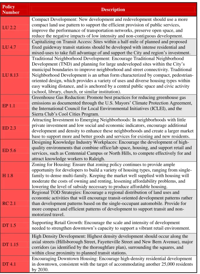
Analysis of Policies and Implementation Actions
Table 2: Example Density-Promoting Policies from the Raleigh 2030 Comprehensive Plan
Policy
Number Description
LU 2.2
Compact Development: New development and redevelopment should use a more compact land use pattern to support the efficient provision of public services, improve the performance of transportation networks, preserve open space, and reduce the negative impacts of low intensity and non-contiguous development.
LU 4.7
Capitalizing on Transit Access: Sites within a half-mile of planned and proposed fixed guideway transit stations should be developed with intense residential and mixed-uses to take full advantage of and support the City and region’s investment.
LU 8.13
Traditional Neighborhood Development: Encourage Traditional Neighborhood Development (TND) and planning for large undeveloped sites within the City’s municipal boundaries to improve neighborhood and street connectivity. Traditional Neighborhood Development is an urban form characterized by compact, pedestrian-oriented design, which provides a variety of uses and diverse housing types within easy walking distance, and is anchored by a central public space and civic activity (school, library, church, or similar institution).
EP 1.1
Greenhouse Gas Reduction: Promote best practices for reducing greenhouse gas emissions as documented through the U.S. Mayors’ Climate Protection Agreement, the International Council for Local Environmental Initiatives (ICLEI), and the Sierra Club’s Cool Cities Program.
ED 2.3
Attracting Investment to Emerging Neighborhoods: In neighborhoods with little private investment and low social and economic indicators, encourage additional development and density to enhance these neighborhoods and create a larger market base to support more and better goods and services for existing and new residents.
ED 5.6
Designing Knowledge Industry Workplaces: Encourage the development of high-quality environments that combine office/lab space, housing, and support retail and services, such as Centennial Campus or North Hills, to compete effectively for and attract knowledge workers to Raleigh.
H 1.8
Zoning for Housing: Ensure that zoning policy continues to provide ample
opportunity for developers to build a variety of housing types, ranging from single-family to dense multi-single-family. Keeping the market well supplied with housing will moderate the costs of owning and renting, lessening affordability problems, and lowering the level of subsidy necessary to produce affordable housing.
RC 2.1
Regional TOD Strategies: Encourage a regional distribution of land uses and economic activities that will encourage transit-oriented development patterns rather than development patterns based on the single-occupant automobile. Provide for more compact and efficient patterns of development to support transit and non-motorized travel.
DT 1.5 Supporting Retail Growth: Encourage the scale and intensity of development needed to strengthen downtown’s capacity to support a vibrant retail environment.
DT 1.15
High Density Development: Highest density development should occur along the axial streets (Hillsborough Street, Fayetteville Street and New Bern Avenue), major corridors (as identified by the thoroughfare plan), surrounding the squares, and within close proximity to planned transit stations.
DT 4.1
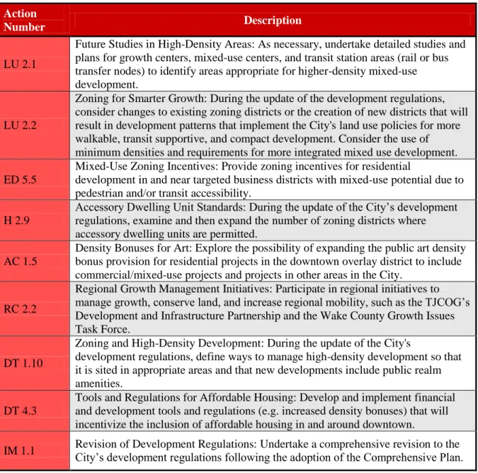
Table 3: Example Density-Promoting Actions from the Raleigh 2030 Comprehensive Plan
Action
Number Description
LU 2.1
Future Studies in High-Density Areas: As necessary, undertake detailed studies and plans for growth centers, mixed-use centers, and transit station areas (rail or bus transfer nodes) to identify areas appropriate for higher-density mixed-use development.
LU 2.2
Zoning for Smarter Growth: During the update of the development regulations, consider changes to existing zoning districts or the creation of new districts that will result in development patterns that implement the City's land use policies for more walkable, transit supportive, and compact development. Consider the use of minimum densities and requirements for more integrated mixed use development.
ED 5.5
Mixed-Use Zoning Incentives: Provide zoning incentives for residential
development in and near targeted business districts with mixed-use potential due to pedestrian and/or transit accessibility.
H 2.9
Accessory Dwelling Unit Standards: During the update of the City’s development regulations, examine and then expand the number of zoning districts where accessory dwelling units are permitted.
AC 1.5
Density Bonuses for Art: Explore the possibility of expanding the public art density bonus provision for residential projects in the downtown overlay district to include commercial/mixed-use projects and projects in other areas in the City.
RC 2.2
Regional Growth Management Initiatives: Participate in regional initiatives to manage growth, conserve land, and increase regional mobility, such as the TJCOG’s Development and Infrastructure Partnership and the Wake County Growth Issues Task Force.
DT 1.10
Zoning and High-Density Development: During the update of the City's
development regulations, define ways to manage high-density development so that it is sited in appropriate areas and that new developments include public realm amenities.
DT 4.3
Tools and Regulations for Affordable Housing: Develop and implement financial and development tools and regulations (e.g. increased density bonuses) that will incentivize the inclusion of affordable housing in and around downtown.
IM 1.1 Revision of Development Regulations: Undertake a comprehensive revision to the City’s development regulations following the adoption of the Comprehensive Plan.
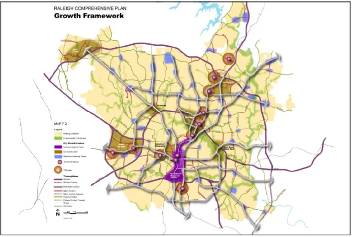
provides a brief description of the character of growth desired in each type of center and
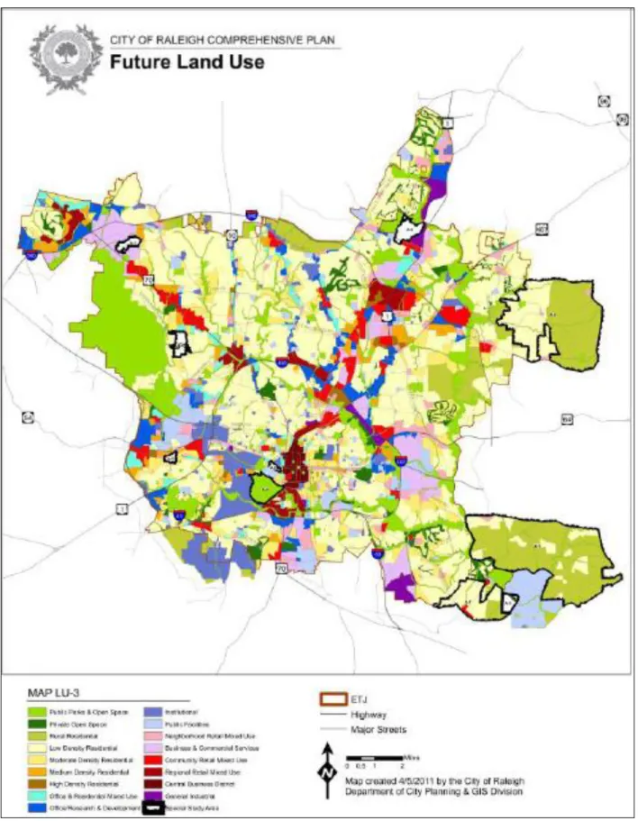
corridor. The four types of centers – Downtown Regional Center, City Growth Centers, Transit-Oriented Centers, and Mixed-Use Community Centers – as well as Urban Corridors and Multi-Modal Corridors, are programmed for compact infill development. This direction provides a general policy framework for future growth and development which is made more specific by the Future Land Use Map. The Growth Framework Map is displayed below in Figure 1.
Figure 1: Raleigh Growth Framework Map
Mixed Use, Community Mixed Use, Regional Mixed Use, and Central Business District – provide for levels of density that would typically be considered high. As the City has undertaken the process of creating a Unified Development Ordinance, it has decided to move towards regulating height rather than unit density, which will require the comprehensive plan to be amended concurrently with the adoption of the Unified Development Ordinance (Interview, February 1, 2012). The Future Land Use Map is displayed on the next page.
Planners who had a substantial role in the development of the plan believe that the Future Land Use Map is the most important policy for encouraging compact development because it provides a clear idea of which land uses are desired by the City. In the past the City had been reactive to development, whereas this plan targets specific areas for growth. This clarity is intended to enable a straightforward entitlement and permitting process. Staff had found that dense, mixed-use products were unduly burned under the previous approval process; this plan attempts to make the process more predictable and simpler. Another critical aspect of the plan in encouraging higher density development is its emphasis on establishing appropriate transitions between new, higher density uses and existing development. These transitions provide a safeguard to
Another overarching observation made by planners is that while the plan enables higher density development, it does not contain strong policy language to require higher density development or prevent low-density development. No recommendation is made, for instance, to establish an urban-growth boundary or enact other policies that might infringe upon property rights. The plan, in essence, relies on carrots rather than sticks. As the real estate market continues to show interest in dense infill products in the City, it is believed that by accommodating such market demand, the plan will foster more compact development patterns. Moreover, planners were concerned about the unintended consequences of strict regulations in a multijurisdictional environment. If low-density single-family development were prevented in Raleigh, it might well simply spillover into surrounding jurisdictions that are even further away from employment centers. One instance in which development regulations may require higher density development is in areas planned for future transit-service. The Transit Overlay District in the draft version of the Unified Development Ordinance envisions minimum building heights (Interview, February 1, 2012 & Interview, February 29, 2012).
A final consideration raised by the interviewed planners is that the City’s decision to pursue a Unified Development Ordinance with a form-based component has necessitated a rethinking of the plan’s treatment of density. This rethinking is predicated on the belief that height and form are more important considerations and more tangible than unit density. As previously mentioned, the plan must be amended to remove references to unit density limits. Thus, some policies
neighborhood residents. Therefore, while it may be possible to implement a height-based incentive zoning provision, such a policy would detract from key strengths of the proposed Unified Development Ordinance (Interview, February 1, 2012 & Interview, February 29, 2012). Analysis of Community, Special Interest, and Not-for-Profit Participation
The creation of the comprehensive plan provided the broader community with a variety of opportunities for participation. These included workshops, community meetings, roundtables, and online feedback mechanisms. Over 1,200 comments were provided on the Public Review Draft of the plan, many of them in support (City of Raleigh, 2009, 7-8). One innovative engagement process initiated by the City is the 21st Century City Lecture Series. While not expressly tied to the plan, the Series brought planning experts including Donald Shoup, Reid Ewing, Robert Cevero, and Christopher Leinberger to the city to speak on salient planning issues. These lectures were very well-attended and helped build support for policy changes in the city such as parking reform in Downtown Raleigh (Interview, February 1, 2012).
Generally, the community was receptive to the plan’s overall vision for compact development. Planners emphasized the need to accommodate development at higher densities in order to grow sustainably and avoid losing open space. However, controversy emerged when it came to
identifying the actual areas for higher density growth on Raleigh’s first-ever Future Land Use Map. Often, neighborhood coalitions led local resistance to prescribed development patterns, and in some instances the map was altered in response to input provided (Interview, February 29, 2012).
In addition to the general public, special interest and not-for-profit groups participated in the creation of the plan, with some taking an active interest in the issue of higher density
convened hundreds of regional stakeholders for the Reality Check Exercise. Triangle Tomorrow is akin to a think tank within the Research Triangle Regional Partnership that focuses on
programming to enhance the Region’s quality of life. ULI Triangle is the local district council of the Urban Land Institute, the nation’s leading non-profit real estate research and education association. As discussed earlier, this process produced three key guiding principles for future growth in the Triangle, including creating vibrant centers. According to organizers interviewed, the process created a platform to discuss the need for more compact development and what this development might look like. It also helped participants grasp the connection between denser development in strategic nodes and open space preservation in a more tangible way than many had conceived of previously. To this end, the Reality Check process has placed compact development more at the forefront of regional conversations about future growth and development (Interview, February 10, 2012 & Interview, February 13, 2012).
Following this process, both Triangle Tomorrow and ULI Triangle helped shepherd several regional initiatives to encourage modified development patterns. ULI Triangle has held seminars on sustainable land use and the feasibility of mixed-use development attended by many members of ULI as well as the general public. Triangle Tomorrow has focused on open space preservation and the value of green space, and has provided technical assistance to communities seeking planning and regulatory solutions to reign in sprawling development (Interview, February 10, 2012 & Interview, February 13, 2012). An important product that has resulted from the
be a really good thing,” which articulates the importance of critical mass to establishing a sense of place and argues that “Higher density offers such benefits as improved security, housing choice and affordability, expanded transportation choices, and enhanced community fiscal health (RTRP & ULI – Triangle, 2011, 8).” The document relates that a growing percentage of the population actually prefers to live in compact neighborhoods, and that assuming 20-30 percent of individuals in the Triangle prefer such neighborhoods, by 2030 800,000 people in the Triangle will prefer such neighborhoods. While this document was released after the Raleigh 2030 Comprehensive Plan was adopted, by providing a multifaceted rationale for creating vibrant centers in Raleigh and elsewhere in the region it can facilitate the implementation of the plan and build public and official support for higher density development.
Neither Triangle Tomorrow nor ULI Triangle took on an advocacy role in relation to the Raleigh 2030 Comprehensive Plan. ULI is a non-advocacy organization and does not take a position on any particular legislation. However, ULI does identify “intelligent densification and
urbanization” as one of its guiding principles and its commitment to educating the public on this principle is made evident through The Value of Vibrant Centers document. Additionally, the membership of ULI is active in planning processes even though the organization does not play an advocacy role. Through the participation of ULI members and Reality Check participants, such as Raleigh Planning and Economic Development Director Mitchell Silver, the principles arising during the Reality Check process were infused into the Raleigh comprehensive planning process(Interview, February 10, 2012 & Interview, February 13, 2012).
of the Downtown Element of the plan, in particular advocating for policies that would spur additional retail development in the Downtown. They also play a large role in the
implementation of the plan, and will be a key actor in the creation of the Downtown Plan beginning later in 2012. This plan will provide much more specific guidance for future
development in Downtown than the Downtown Chapter of the comprehensive plan, including visual renderings of desired urban design outcomes. It is hoped that this visual specificity will provide clear signals of desired development forms to the development community and help the community envision the future Downtown (Interview, February 17, 2012). By providing strong representation for Downtown interests and offering the capacity to implement Downtown projects, the Downtown Raleigh Alliance is a leader in nurturing infill development in the urban core.
WakeUp Wake County is a citizen-advocacy group that provides a critical voice for sustainable development patterns in Wake County, and was an important participant in the Raleigh
comprehensive planning process. The group envisions growth that encapsulates complete,
pedestrian-oriented streets, appropriate land use and transportation connections, mixed land uses, and equitable development. During the planning process, the group attended meetings, offered comments, and engaged with City staff. An interviewed WakeUp Wake County employee is satisfied with the plan’s overall vision and goals, and the Growth Framework that identifies specific nodes and corridors for more intense development. The Unified Development
opportunities for residents at different stages in life (Interview, February 10, 2012). City planners believe that WakeUp Wake County provided constructive criticism on the plan and was a key actor in engendering public interest and awareness of the process (Interview, February 1, 2012 & Interview, February 29, 2012). As an organized and active citizen group with a clear agenda, WakeUp Wake County is a formidable supporter of compact development in Raleigh.
Finally, the participation of the development community in comprehensive planning processes is also important to the realization of higher density development in the region. While no formal non-profit organization exists, several developers committed to fostering more sustainable development patterns banded together to provide input during the Raleigh comprehensive planning process as a group (Interview, February 10, 2012). An interviewed developer related it is critical for developers to become involved in such processes and weigh in on debates
surrounding the location and intensity of development. It is especially helpful when a community is able to communicate where it desires higher density development and which uses are tolerable in which locations. The developer believes that Raleigh is doing an excellent job of facilitating compact development through its planning initiatives (Interview, February 24, 2012).
Interviewed planners relate that making the entitlement process more straightforward was a key objective of the comprehensive planning process. Having a predictable and transparent
Morrisville Town Center Plan and Morrisville Land Use Plan, 2009-2035
The Town of Morrisville has undertaken two major land use planning processes in recent years, the Morrisville Town Center Plan and Morrisville Land Use Plan, 2009-2035. The Town Center Plan was adopted by the Morrisville Board of Commissioners on January 22, 2007, and the Land Use Plan was adopted on March 24, 2009, concurrently with the Morrisville Transportation Plan, 2009-2035. According to the Executive Summary of the Town Center Plan, “This plan describes a vision for creating a vibrant Town Center at Morrisville’s historic crossroads to help ensure that residents continue to enjoy the best qualities of small-town living as the community grows” (Town of Morrisville, 2007, 5). The plan contains four chapters, a summary of existing conditions in the Town Center, a description of the planning process and overview of the conceptual design, a more comprehensive description of the design, and an implementation section. The plan is in essence a small area plan for the historic crossroads area. By contrast, the Land Use Plan is a much broader comprehensive planning document that is intended to be “the foundation of the Town’s land use and development policies” (Town of Morrisville, 2009, 5). The first three sections provide an overview of the planning process and purpose of the document, a summary of the history and geographic context of the Town, and a description of current land uses and recent development trends. The fourth section introduces the Vision, Goals, and Policies that are intended to guide future development, while the next chapter
Analysis of Goals and Objectives
Both of these plans outline a strong vision for more vibrant centers in the Town of Morrisville, with the Land Use Plan being somewhat more direct in addressing the challenge of higher density development. The Town Center Plan acknowledges that the center “lacks identity and presence because of the lack of building massing and any sense of scale” (Town of Morrisville, 2007, 10). The description of the conceptual design of the area contains several references to higher density development. The mixed-use civic/cultural area is envisioned to contain “a collection of small- to medium-scale buildings,” the new residential district is thought to be “well suited for new housing at a slightly higher density than that found elsewhere in the vicinity,” and the boundary area is targeted for “a mix of housing types, somewhat higher than the surrounding densities but not out of scale with the area” (Town of Morrisville, 2007, 18-22). Thus, while the Town Center Plan outlines a vision for more compact development forms, it is quite tentative. This may owe to the low-density development patterns of the Town and the historic character of the crossroads area.
Uses chapter begins with a set of Development Principles “that set a framework for guiding the design of development throughout Morrisville” (Town of Morrisville, 2009, 18). These
principles strongly encourage compact development, connectivity, and mixed land uses as a means to achieve several positive outcomes, including protecting open space, enhancing the pedestrian experience, and reducing traffic congestion. This section is where the plan most clearly articulates the benefits of compact land uses. By emphasizing compact, connected development as a solution to many of the most serious issues confronting the town – traffic congestion, rapid loss of open space, and residential isolation – the plan provides a clear
rationale for the Future Land Use Map and Categories that follow. Moreover, by recognizing the importance of protecting existing neighborhoods from encroaching development, the plan strikes a balance between encouraging compact development and satisfying local residents.
Town planners interviewed emphasize the incredible magnitude of growth that has occurred in Morrisville over the past few decades and how perceptions of this growth impacted the planning processes. In particular, negative development impacts like traffic congestion are widely viewed to be hampering quality of life in the Town. As a result, in order to build support for more compact development, members of the Town Council were invited to tour successful mixed-use projects in the region such as Southern Village and Meadowmont in Chapel Hill. The Council responded very positively to these visits, which helped build momentum for the moderate scale compact development envisioned by the Town Center planning process. Planners also
emphasized the findings of the market study conducted for the Town Center, which
Analysis of Policies and Implementation Actions
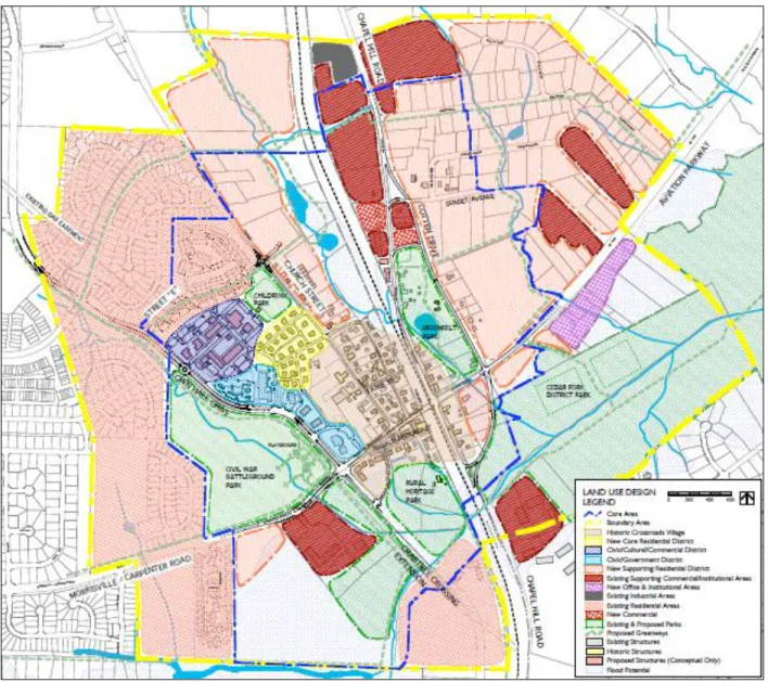
The primary policy guidance provided by the Town Center Plan is the Land Use Design Map and associated descriptions of desired development in the nine districts. The Land Use Design Map is displayed on the next page in Figure 3. Higher density residential development is
prescribed for three of the districts: Franklin-Upchurch Street in the Historic Crossroads Village, the New Core Residential District, and the New Supporting Residential District. As in the
Figure 3: Town Center Land Use Design Map
density development of the forty-two action items enumerated in the plan. A new Unified Development Ordinance is the key mechanism for implementing the policies recommended in the plan (Town of Morrisville, 2009).
Table 4: Example Density-Promoting Policies from Morrisville Land Use Plan, 2009-2035
Policy
Number Description
1D
Concentrate higher-density, mixed-use development near existing and proposed transit centers, and at activity centers to provide services to Town citizens and daytime employees in a pedestrian-friendly environment.
3A
Establish development patterns supportive of a walkable, multi-modal community, including higher-density residential development and complementary land uses in the Town Center and around planned and potential transit and activity centers.
3C Encourage infill and redevelopment of existing areas as a way to promote compact, efficient development, and support transportation options.
Table 5: Example Density-Promoting Actions from Morrisville Land Use Plan, 2009-2035
Action
Number Description
1.1
Amend Zoning Ordinance. Ensure that current zoning district descriptions are compatible with the general intent of the land use districts in the plan. Incorporate zoning categories for small-scale mixed use and transit oriented development. Note that this does not imply rezoning properties to match the land uses in this plan - only ensuring that matching zoning categories exist to allow rezoning upon a property owner’s request. This is a short-term solution; development of the Unified Development Ordinance in item 1.4 is the long term solution for amending the zoning ordinance.
1.4
Create Unified Development Ordinance. This ordinance revision will allow for important updates and clarification of existing codes, making it easier for developers to understand the Town’s needs. It will provide an opportunity to formalize the future land use map presented in this Plan. In particular, the UDO will take a focused look at the design of Regional Activity Centers and address
compatibility with and transitions to surrounding uses.
1.5
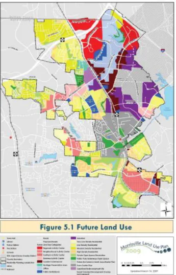
As in Raleigh, the Future Land Use Map is the most critical tool for fostering higher density development by mapping specific areas where such development is to be encouraged. The map is intended to be interpreted along with the written policies of the plan and its stated purpose “is to graphically depict a general land development pattern that seeks to achieve the goals of the Plan” (Town of Morrisville, 2009, 19). Subsequently, the Future Land Use Categories are listed and their function, preferred uses, and general policies and development character are described. Photos of encouraged and discouraged development patterns in each category are also included. Several categories allow compact development, among them the Regional Activity Center, Neighborhood Activity Center, Southern Activity Center, Business Activity Center, Corridor Commercial, Office, Residential (if high density), Future McCrimmon Small Area / Master Plan Area, Town Center Planning Area and TOD District. The mixed-use activity center districts in particular emphasize a vertical mix of uses, compact walkable environment, and density transitions from the center of the node to its outskirts in order to minimize impacts on existing neighborhoods. The TOD District, which envisions particularly dense development, is not yet definitively mapped, although the plan does anticipate that the TOD District will be applied to the Superfund Redevelopment Site. By articulating the scale of development desired in each area, the Future Land Use Map and Cateogires provide valuable direction to the Unified Development Ordinance and clear signals to the development community.
offered to mitigate the impacts of the development. This is in effect an up-zoning from the former limit of eight units per acre, a regulation which could not even accommodate garden apartments. Coupled with transition districts that smooth the transition from new compact
development to existing neighborhoods, the plan’s policy guidance provided the community with a compelling rationale to accept higher densities. In early 2012, the Unified Development
Ordinance creation process is just now being initiated by the Town, with the first public meeting held on February 20, 2012. The Unified Development Ordinance will codify the policies
contained in the Land Use Plan in a similar fashion to how the Town Center Code codified the policies expressed within the Town Center Plan (Interview, February 15, 2012).
As in Raleigh, the plans shy away from recommending a regulatory framework that would expressly restrict development in some areas in order to encourage higher density development in others. The emphasis is on allowing the market to operate and permitting higher density development that might be demanded, as long as care is taken to minimize the adverse impacts of such development on existing neighborhoods. However, a development restriction in the Town may encourage higher density development in unregulated areas as a secondary effect. Residential development is prohibited in the Airport Overlay District in order to prevent residential dissatisfaction with the noise emanating from airplane traffic. This district covers roughly one quarter of the town. (Interview, February 15, 2012).
Analysis of Community, Special Interest, and Not-for-Profit Participation
Both the Town Center Plan and Land Use Plan offered community members multiple
illustrate desired development forms by showing photos of encouraged and discouraged development types for each Land Use Category. Frequently, the photos of encouraged
development in the activity centers display denser, pedestrian-oriented development patterns, while the discouraged development photos show low-density auto-oriented land uses (Town of Morrisville, 2009). Again, the effect is to enhance public acceptance of higher density
development by displaying scenes of compact development that is compatible with the Town’s character.
Conversations with planners involved in the planning processes reveal the critical ways in which the public influenced how the plans wrestled with issues of density. During the creation of the Town Center Plan, little opposition to the overall vision was manifest. When it came to the creation of the Town Center Code, some property-owners were unhappy if their property was not up-zoned. Yet the Land Use Plan, because it concerned the overall direction of the entire
community, provoked stronger reactions about planned higher density development. While some community members envisioned a low-density bedroom community, others sought more intense uses within the community. The Land Use Plan attempts to accommodate both of these
competing visions by creating strategic nodes of higher density while accommodating low-density development outside these nodes. Public input played a large role in the shaping of these nodes, and in some cases changed them. Community members expressed concern with one of the Regional Activity Centers planned for the community, and as a result the area was refashioned as the “Southern Activity Center” (Interview, February 15, 2012). Having a robust public
involvement process thus produced a plan that had survived and been strengthened by
approach seems likely to assist in building public support for the codification of the plan’s vision.
Research Triangle Park Master Plan
Research Triangle Park (RTP) has served as a cornerstone of the Triangle’s economy since its founding in 1959. The 7,000 acre park is home to over 170 companies and 40,000 workers (Bracken, 2010). Yet the original development scheme of the park has not been updated in over forty years (Research Triangle Foundation, 2010). Some fear the park’s competitive position is eroding, and that it’s distinctly suburban character may be to blame. In 2010, Research Triangle Park had one of the highest vacancy rates in the region (Bracken, 2010). The Research Triangle Foundation, the non-profit board which manages RTP, decided to embark upon a master
planning process to re-envision future growth and development at the Park. The Foundation hired a consulting team led by the urban design firm Cooper, Robertson & Partners to direct the effort (Research Triangle Foundation). According to the Research Triangle Foundation, the Master Plan “will consider changes needed within the Park’s boundaries to ensure RTP remains a pre-eminent and globally competitive location for research and development operations and a leading global center of innovation” (Research Triangle Foundation, 2010). Since the Master Plan has not yet been finalized and released to the public, this analysis relies on public statements by the Research Triangle Foundation regarding the plan’s goals, objectives, and policies, in conjunction with insights provided by Research Triangle Foundation employees during interviews.
Analysis of Goals and Objectives
Bob Geolas, President and CEO of the Research Triangle Foundation, is that “RTP should be highly collaborative – a place that brings people together in new dense, urban centers with amenities and services” (Geolas, 2012). Other principles are that the park should be authentic to North Carolina, inspiring, and accessible. Research Triangle Foundation recognizes that
consumer preferences in the knowledge economy do not favor the Park’s current spatial
structure, and in order to remain a desirable and innovative place for businesses, it must adapt. In particular, the revitalization of Downtown Durham and Downtown Raleigh is luring away
traditional spatial patterns. Moreover, compact and innovative development forms would offer new opportunities for small businesses and start-ups to locate in the Park. Just outside of the Park’s boundaries, compact, mixed-use developments like Davis Park and Parkside Town Commons were occurring, and the Park believed that such development types could be accommodated internally as well (Interview, February 6 & Interview, February 17). Analysis of Policies and Implementation Actions
In order to achieve its vision for more compact development, a number of policy changes will be necessary. According to a newspaper article published at the outset of the process, “Among the changes on the table is altering RTP's zoning and land-use rules to allow for high-density centers that could be home to retail and residential development - things that are not currently allowed” (Bracken, 2010). Planners involved in the project confirm that this has become the Master Plan’s general framework for future compact development. Rather than recommend the entire Park adapt to a compact development form, strategic nodes of higher density development are
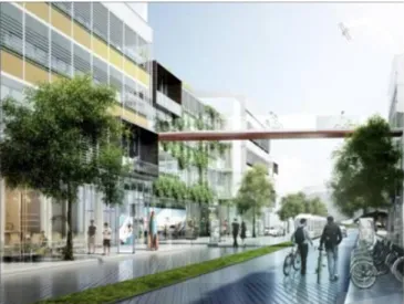
Figure 5: “A vision for the Research Triangle Park of the future”
Implementing this development policy will require multiple actions involving a range of actors. The Park’s covenants, zoning regulations, and bylaws must all be altered. The Park’s restrictive covenants are overseen by the Board of Design and the Owners and Tenants Association, and regulate the use of land within the Park. In order to amend the covenants to allow for residential or other new uses, a vote of land owners and tenants is required, with the weight of each
Park must work with the legislature if it wants to change the amount of residential development allowed. A technical appendix to the plan contains more details on possible specific zoning changes, although the planning team remains open to new ideas. Generally, however, the plan is more focused on the vision of the park than specific implementation measures (Interview, February 6 & Interview, February 17).
While these policies and actions to increase density in specific areas have generally garnered support, the plan avoids requiring companies to develop parcels more intensely. Like the Raleigh and Morrisville planning processes, it allows higher densities but does not require them.
However, Research Triangle Foundation may be able to stimulate higher density development by actively encouraging it in strategic nodes by working with developers and landowners, and by leveraging land it currently owns for mixed-use development projects. The consultant team hired for the planning process had originally envisioned restricting development in some areas of the Park while increasing allowable intensity in other areas. Given the Park’s relatively small geographic footprint, Research Triangle Foundation is unlikely to recommend restrictions on development. Additionally, the consultant team had recommended a parking limit of four spaces for every 1,000 square feet of built space. Again, the Research Triangle Foundation is
Analysis of Community, Special Interest, and Not-for-Profit Participation
The development of the Research Triangle Park Master Plan has involved a variety of stakeholders, including companies in the Park, Durham and Wake counties, and nearby municipalities. Companies in the Park have generally been receptive to the idea of nodes of higher density within the Park. The Research Triangle Foundation commissioned a survey of companies in the Park which found that mixed-use development was considered a top priority. One company located in the Park that routinely conducts surveys of its employees has found that both younger and older employees would prefer a more compact environment, while middle-aged employees are more content with the Park’s current structure. Companies located in close proximity to the proposed nodes have had a more mixed reaction, with some in favor and others more cautious. The Owners and Tenants Association has been involved throughout the process, briefing companies on the plan’s progress and providing feedback on draft iterations (Interview, February 6, 2012). The process has involved planners from around the region, many of whom have participated through the Center of the Region Enterprise (CORE) group of the Triangle J Council of Governments. The County Commissioners and the Chambers of Commerce from both Durham and Wake counties have also participated in the process. Generally, these regional stakeholders have supported the plan’s vision. Planners believe that part of the reason the plan has been embraced is because it is made clear that Research Triangle Park’s intention is not to compete with neighboring communities, but rather to provide options than enhance the
competitiveness of the State and region. (Interview, February 6, 2012 & Interview, February 17, 2012).
national ULI members, researchers, and policymakers at the outset of the Master Planning process. This panel recommended that the Park incorporate higher density and mixed-use development. (Interview, February 17, 2012 & Interview, February 12, 2012). Moreover, the Research Triangle Foundation was a sponsor of the Reality Check exercise, and many
Conclusion
This report has endeavored to demonstrate how the Research Triangle region is leveraging the planning function to encourage more compact development patterns. A plethora of research indicates that compact development forms offer a variety of economic, environmental, and public health benefits, in addition to meeting the preferences of an increasingly large segment of the population. The Triangle region can hope to realize such benefits by enabling higher density development. The Raleigh 2030 Comprehensive Plan, Morrisville Town Center and Land Use Plan, and Research Triangle Park Master Plan have been examined in order to understand the extent to which more compact development forms were a goal of the processes, which policies and actions were chosen to implement these development forms, and how the community and not-for-profit organizations shaped these processes. This section will summarize the findings of this analysis and offer recommendations to other communities considering how to encourage compact development through planning processes.
Summary of Findings
implement the plan, provisions within the plan about density limits and bonuses must now be reconsidered. Citizens generally supported the concept of compact development, but were more concerned when such development was proposed to be allowed near their neighborhoods. Given the size of Raleigh and its importance within the Triangle region, a variety of not-for-profit groups joined citizens in participating in the planning process. ULI – Triangle and Triangle Tomorrow helped frame the regional discussion of higher density development through the concurrent Reality Check process and subsequent implementation measures. The Downtown Raleigh Alliance advocated for Downtown interests during the process, while WakeUp Wake County advocated for smart growth policies and brought citizen concerns over unsustainable land use patterns to the fore.
visuals depicting attractive examples of compact development. With the Town’s smaller size, planning efforts attracted little attention from not-for-profit groups operating in the region. Research Triangle Park’s pending Master Plan is guided by a commitment to refashioning the Park’s traditional suburban development model in order to make it more competitive in today’s economy. With companies increasingly attracted to vibrant urban centers, the Park’s leadership realized changes in the development pattern were needed. In order to implement a vision for strategic nodes of higher density within the Park, changes to the Park’s zoning regulations, covenants, and bylaws will be sought. This process will require the participation of companies within the Park, Durham and Wake Counties, and the state legislature. While the Research Triangle Foundation is hesitant to adopt regulations that might require higher densities
throughout the Park, the Foundation may use land it currently owns to develop compact, mixed-use projects in order to catalyze the Park’s transformation. It is also considering less restrictive height limitations than those recommended by the consultant team. Companies within the Park and stakeholders from around the region have generally supported the Park’s vision, with many companies citing mixed-use development as a key desire. While few special-interest groups have become involved in the process, a ULI advisory services panel that recommended higher density development and mixed-uses was conducted at the beginning of the Master Planning process.
Recommendations for Fostering Higher Density through Planning Processes