The 2015 International Conference on the Future of ASEAN (ICoFA 2015) Special Issue
50
Integration of Digital Cadastral Database Spatial Coordinates Towards
Mapping in Google Earth
Muhammad Fadhil Jasmee, Mohamed Nasri Hj Rani, Jasmee Jaafar
Univrersiti Teknologi Mara, 40450 Shah Alam, Selangor, Malaysia
Khairulazhar Zainuddin, Mohd Zainee Zainal
Universiti Teknologi MARA Perlis, 02600 Arau, Perlis
Abstract
With the advancement of Information and Communications Technology (ICT), locating land parcel physically on the ground is time consuming and costly. In order to facilitate locating land parcel on the ground easily, a base map is required as a guide in determining the land parcel location correlatively on the ground. Google Earth is a free application and provides free satellite images of the earth surface. With the aid of Google Earth satellite images as a base map, locating the land parcel physically on the ground would be easier. This study focuses on the error that may arise when overlaying DCDB spatial coordinates on the Google Earth environment. In this study, the assessments are divided into qualitative and quantitative assessments. The quantitative assessment discussed on the analysis of the coordinate displacement based on the RMSE (Root Mean Square Error) computation, and as for the qualitative assessment, discussion on the shifted DCDB land parcel displayed on the Google Earth platform are discussed. The RMSEx and RMSEy value are computed 1.714 m and 3.883 m respectively. By applying the constant error to the DCDB land parcel, the shift error is eliminated and aesthetical value is achieved and served a diversity of applications.
Keyword: Google Earth, Google Earth Accuracy, Digital Cadastral Database.
Introduction
The preparation of cadastral Certified Plan in Malaysia is under the jurisdiction of the Department of Surveying and Mapping Malaysia (DSMM). Cadastral plans were prepared based on a standard land surveying procedure (DSMM, 2009) with high-accuracy measurements and conducted by land surveyors. In accordance to the National Land Code (1965), the plan is used for defining land ownership based on the demarcated boundary marks.
With the advancement of surveying technology, field surveying equipment such as the total station and the use of Global Position System Real Time Kinematic (GPS-RTK) in the determination of surveyed points has emerged. These technologies support the acquisition of digital data storage and automation in adjustment and the determination of the surveyed coordinates with ease. Having information in digital formats, the information of surveyed points can be
The 2015 International Conference on the Future of ASEAN (ICoFA 2015) Special Issue
51 even the land owner. It is known that, the surveyed
parcel information for land ownership purposes is kept in the Digital Cadastral Database (DCDB). This information could be retrieved based on procedures governed by the DSMM (Department of Survey and Mapping Malaysia).
In this study, an approached integrating land parcel coordinates stored in the DCDB and Google Earth platform towards locating the land parcel physically on the ground is explored. Ability to display the land parcel location on Google Earth will help locating the boundary marks certain extend. Furthermore, scouting potential land area for development and planning phase will be of high value as the Google Earth provides great extent of the milieu.
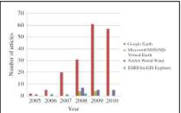
Since the released of Google Earth geobrowser in 2005, it has gain popularity among users from all age groups. Apart from the ability to ‘fly’ and observe different places around the world by a click of a finger, another advantage is the usage of KML (Keyhole Markup Language) in Google Earth (Bailey and Chen, 2011). This allows the user to overlay spatial dataset within the Google Earth environment and the first programmable geobrowser with the ability to view and graphically edit using KML files. At present, virtual globes and GIS (Geographic Information System) software support KML, as KML became an Open Geospatial Consortium (OGC) standard in 2008 (Le, 2012). The popularity of Google Earth is illustrated in Figure 1 (Le, 2012).
Figure 1: Popularity of Google Earth from 2005- 2010 (Le, 2012)
Google Earth Accuracy
Google Earth accuracy assessments have been conducted by previous researches such as Becek (2011), Potere (2008) and Hernandez (2013) in
determining the Google Earth horizontal accuracy. A series of independent horizontal accuracy assessments had been undertaken at both global and regional scales. At the global scale, accuracy assessments have been assessed using as reference datasets of low (Potere, 2008) or undocumented (Becek; Ibrahim, 2011) horizontal accuracy. The accuracy assessment conducted by Potere (2008) shows that the horizontal accuracy of Google Earth imagery is 39.7 meters, conducted using a low accuracy dataset. As for the study conducted by Becek (2011), the horizontal positional accuracy of Google Earth imagery ranges from less than 10 meters to 1500 meters. The study by Becek (2011) was conducted using 2000 points of runways from all over the world provided by the Global Elevation Data Testing Facility (GEDTF). At regional scales, a study was conducted by Benker and Langford (2011) using high-accuracy field measurements in the Big Bend region of Texas, USA. From the study conducted by Benker and Langford (2011) found that Google Earth imagery has a horizontal mean error of 6.95 meters.
A study conducted by Hernandez (2013) on horizontal positional accuracy of Google Earth Imagery over rural areas shows that the accuracy of (horizontal X) RMSEx is 3.8 meters and (horizontal Y) RMSEy 3.2 meters using 466 control points. The inconsistency of the reported accuracy might due to the nature of control points and projection adopted for the corresponding area.
Digital Cadastral Database (DCDB)
The 2015 International Conference on the Future of ASEAN (ICoFA 2015) Special Issue
52
Methodology
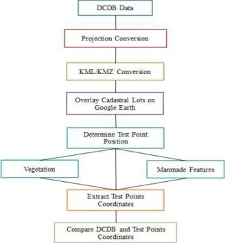
With the aid of the stored database, integrating the dataset for viewing on Google Earth environment seems appealing. However, the accuracy achieved and determining the constant error would be of high interest. In determining the constant error to be applied to the cadastral land parcel, several task needed to be taken before determining the RMSEx and RMSEy. The methods used in this study are shown in Figure 3. The DCDB land parcel are obtained in the shapefile format and its coordinate system are in Cassini Soldner. Therefore, projection conversion and KML/KMZ conversion are needed in this study accomplished using the Global Mapper software.
Figure 3: Methodology of the study
Referring to Figure 3, the converted KML/KMZ land parcels are then overlaid onto the Google Earth environment and the process of selecting suitable test point are conducted. In determining the test point in Google Earth, visible vertices are used as a guide in determining the DCDB land parcel location on Google Earth as shown in Figure 4. In this study, a total of 114 test points (Figure 5) are selected within the study area to be used for the computation of RMSEx and RMSEy. The test point locations are distributed randomly all over the study area. This is to ensure the value obtained (RMSE) can be applied to the entire land parcel within the study area.
Figure 4: Visible vertices on Google Earth (Hernandez, 2013)
The test point’s coordinates, land parcel number and the certified plan number are retrieved from the database for the process of computing the RMSE.
Figure 5: Test point within the study area (Google Earth, 2014)
Result
The 2015 International Conference on the Future of ASEAN (ICoFA 2015) Special Issue
53 respectively. As for the qualitative assessment it is to
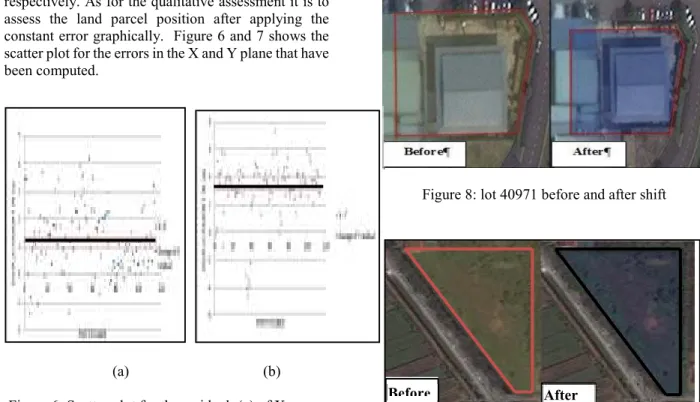
assess the land parcel position after applying the constant error graphically. Figure 6 and 7 shows the scatter plot for the errors in the X and Y plane that have been computed.
(a) (b)
Figure 6: Scatter plot for the residual; (a) of X errors (b) Y errors
Referring to Figure 6, the residuals for the X and Y plane are calculated by subtracting the coordinate’s values from the test point (X’) with the same position stored in the DCDB land parcel (X). The line indicates the average value and the points are the residual of each point. All the computation result referred to Table 1 shows the respected values computed.
Table 1: Computed values for tested points ∆ X ∆ Y
Test Points 114 114 Average 1.263 3.222 Std. Deviation 1.164 2.177 RMSE 1.714 3.883
Referring to Table 1, the standard deviation for the horizontal component of X and Y is 1.164 m and 2.177 m with the RMSEx 1.714 m and RMSEy 3.883 m respectively. The RMSE values computed will be used as the constant to shift the DCDB land parcel in the X and Y plane. The adjusted DCDB land parcel are then overlaid onto Google Earth to assed the land parcel qualitatively. Figure 8 and Figure 9, shows the effect of before and after adjusted DCDB land parcel.
Figure 8: lot 40971 before and after shift
Figure 9: Lot 81 before and after applying shift
Referring to Figure 8, the adjusted DCDB land parcel are shifted inwards within the boundary (walls) and as for Figure 9, the land parcel are shifted neatly within its boundary. The characteristic of the adjusted land parcel can be seen directly as for the nature of the shift is the same towards the entire DCDB land parcel. This is because the correction values (constant) used are the same.
Conclusion
Google Earth support a variety of land related activities based on the automated display of satellite images. Therefore, it shown that, by integrating spatial coordinates of land parcel the ability to locate land parcel of interest will be much easier. However, understanding the accuracy of the displayed dataset should be investigated as errors propagate through analysis. In this study, it is shown that by applying the constant shift on the spatial land coordinates, the accuracy of the displayed land parcel could be enhanced. The suggested approached will eventually support a variety of land related activities.
Acknowledgement
The 2015 International Conference on the Future of ASEAN (ICoFA 2015) Special Issue
54 The authors acknowledge the financial support for this
study by PJIM&A UiTM Perlis: RAGS RESEARCH GRANT (600-RMI/RAGS 5/3 (193/2013)
References
Abdullah Hisam Omar, 2006, Development of Automated Cadastral Database selection and Visualization System to support the realization of modern Cadastre in Malaysia.
Bailey, J.E. and Chen, A., 2011, The role of virtual globes in geoscience. Computers & Geosciences, 37, pp. 1–2.
Becek, K., Ibrahim, K. and Barussalam, B., 2011, On the positional accuracy of the Google Earth imagery. In FIGWorkingWeek 2011, Bridging the Gap Between Cultures, Working Paper No. 4947, 18–22 May, Marrakech, Morocco.
Benker, S.C; Langford, R.P.; Pavlis, T.L 2011,. Positional accuracy of the Google Earth terrain model derived from stratigraphic unconformities in the Big
Bend region, Texas, USA. Geocarto International, 26(4), 291-301
Goodchild, M.F., 2008, The use cases of digital earth. International Journal of Digital Earth, 1, pp. 31–42.
Le Yu & Peng Gong. 2012 Google Earth as a virtual globe tool for Earth science applications at the global scale: progress and perspectives. International Journal of Remote Sensing, 33:12, 3966-3986
Department Of Survey and Mapping Malaysia (DSMM).2009. Technical Guide to the Coordinate Reference Systems
Potere, D., 2008, Horizontal positional accuracy of Google Earth’s high-resolution imagery archive. Sensors, 8, pp. 7973–7981.