J. Range Manage.
55: 406-411 July 2002
Population cycles of broom snakeweed in the Colorado Plateau and Snake River Plains
M.H. RALPHS AND K. D. SANDERS
Authors are Rangeland Scientist, USDA/ARS Poisonous Plant Lab., 1150 E. 1400 N., Logan Utah 84341; and Professor, Rangeland Ecology and Management, Univ. Idaho, PO Box 1827, Twin Falls, Ida 83303.
Abstract
Broom snakeweed (Gutierrezia sarothrae (Pursh) Britt. &
Rusby) is one of the most widespread range weeds in North America. The objective of this study was to monitor broom snakeweed populations in the salt-desert shrub community of the Colorado Plateau and in crested wheatgrass (Agropyron deserto- rum (Link) Schultes) seedings typical of the Snake River Plains and Great Basin, and determine if its population cycles are relat- ed to precipitation patterns. Foliar cover of broom snakeweed and associated plant species was measured along 7.6 or 33 m transects by the line intercept technique. Density of snakeweed age classes (seedling, juvenile, mature) was counted in 1 m2 quadrats at the beginning and end of each transect. Correlations were made between snakeweed cover and density, and seasonal precipitation. The snakeweed population at the Colorado Plateau site completed 2 cycles over the 13 year study period, dying out in the drought of 1989-90 and again in 2001. There were positive correlations between density of snakeweed classes and seasonal precipitation: seedlings with spring precipitation (r = 0.63); juve- niles with winter precipitation (r = 0.69); and mature plants with previous fall precipitation (r = 0.62). Only 1 cycle occurred at the Snake River Plains site. Following the snakeweed invasion into crested wheatgrass seedings in the mid 1980's, the popula- tion was at the top of its population cycle when the study began in 1990, dropped back and fluctuated between 6-10% cover from 1992 to 1999, and died out in 2001. Although density of mature plants did not change much during the middle part of the study, the change in snakeweed cover was correlated with spring (r = 0.81) and total precipitation (r = 0.60), reflecting increase and decrease in size of plants in response to precipitation.
Key Words: broom snakeweed, Gutierrezia sarothrae, popula- tion cycle, poisonous plant.
Resumen
"Broom snakeweed" (Gutierrezia sarothrae (Pursh) Britt. &
Rusby) es una de las malezas de pastizal mas ampliamente espar- cidas en Norte America. El objetivo de este estudio fue monitore- ar las poblaciones de "Broom snakeweed" en las comunidades arbustivas del desierto salado de la meseta Colorado y en las siembras de "Crested wheatgrass" (Agropyron desertorum (Link) Schultes) tipicas de las planicies del Rio "Snake" y la Gran Cuenca y determinar si sus ciclos de poblacion estan relaciona- dos a los patrones de precipitacion. La cobertura foliar de
"Broom snakeweed" y de las plantas asociadas se midio a to largo de transecto de 7.6 o 33 m mediante la tecnica de intercep- cion de linea. La densidad por clases de edad de "snakeweed"
(plantula, juvenil y madura) se conto en cuadrantes de 1 m2 al inicio y final de cada transecto. Se hicieron correlaciones entre la cobertura y densidad de "snakeweed" y la precipitacion esta- cional. La poblacion de "snakeweed" del sitio meseta Colorado completo dos ciclos en los 13 anos del periodo de estudio, muriendo en la sequia de 1980-1990 y de nuevo en 2001. Hubo correlaciones positivas entre la densidad de clases de "snake- weed" y la precipitacion estacional: las plantulas con la precip- itacion de primavera (r = 0.63); juveniles con la precipitacion de invierno ( r = 0.69) y las plantas maduras con la precipitacion del otono previo ( r = 0.62), en el sitio del Rio "Snake" solo ocurrio un ciclo. Despues de la invasion del "Snakeweed" en las siembras de "Crested wheatgrass", a mediados de la decada de 1980, la poblacion estuvo en la cumbre de su ciclo de poblacion cuando el estudio comenzo en 1990, retrocedio y fluctuo entre 6-10% de cobertura de 1992 a 1999 y murio en 2001. Aunque la densidad de plantas maduras no cambio mucho durante la parte media de este estudio, el cambio de cobertura del "Snakeweed"estuvo cor- relacionado con la precipitacion de primavera (r=0.81) y la pre- cipitacion total (r = 0.60), reflejando aumentos y disminuciones en el tamaiio de las plantas en respuesta a la precipitacion.
Broom snakeweed (Gutierrezia sarothrae (Pursh) Britt. &
Rusby) is the most ubiquitous range weed in North America. It extends from the cold-temperate climate of Canada to the sub tropical areas of Mexico, from the sub-humid Great Plains to the acid deserts of the Great Basin, and up the Sierra Nevada and Rocky Mountains. It is now a principal component of the follow- ing major plant communities: creosote bush, desert grassland, short-grass prairie, salt-desert shrub, sagebrush steppe, pinyon/juniper, and mountain brush.
Manuscript accepted 20 Sept. 02.
The early literature associated the increase of broom snake- weed with overgrazing, which reduced desirable vegetation and allowed broom snakeweed to increase where it already existed, and invade deeper soils and more productive sites (reviewed by McDaniel and Torrell 1987). However, it has even increased in good condition plant communities in the absence of grazing (Chew 1982, Hennessy et al. 1983). Other disturbances (such as fire, drought and chaining) can also cause it to increase (Arnold et al. 1964, Parker 1939, USFS 1937). It is very competitive with desirable grasses and greatly suppresses forage production (McDaniel et al. 1982, Ueckert 1979). It is not palatable to most
406 JOURNAL OF RANGE MANAGEMENT 55(4) July 2002
large ungulates (Pieper 1989), and it is toxic to livestock causing abortions (Dollahite and Anthony 1957). Platt
(1959) ranked it one of the most undesir- able plants in the various regions of the West. On many localized rangelands of the southwest, it is the most significant problem limiting forage and livestock pro-
duction.
Broom snakeweed is a short-lived,
perennial, suffrutescent shrub whose pop- ulations appear to be related to climatic patterns. In southern New Mexico, broom snakeweed populations died out during droughts in 1970-71, 1984, and 1994, but rapidly reestablished from seedlings dur- ing the following wet winters and springs (Pieper and McDaniel 1989, Beck et al.
1996, 1999, McDaniel et al. 2000).
The objective of this study was to moni- tor broom snakeweed populations in the salt-desert shrub community of the Colorado Plateau and in crested wheat- grass seedings typical of the Snake River Plains and Great Basin, and determine if changes in its cover and density were related to precipitation patterns.
Methods
The Colorado Plateau site was located 10 km south of Ferron, Ut. at 1,890 m ele- vation (N 38° 57.74', W 111 ° 12.17').
Annual precipitation averaged 22 cm with a bimodal pattern of winter snow and sum- mer monsoonal thunderstorms. Soils were fairly uniform Ravola loam (fine-silty, mixed, active, calcareous, mesic Typic Torrifluvent) derived from alluvium from Mancos shale and sandstone benches. The range site was a desert loam with a salt- desert shrub plant community consisting of shadscale (Atriplex confertifolia (Torn.
& Frem.) Wats.), Gardner saltbush (A.
gardneri (Moq.) D. Dietr.), mat saltbush
(A. corrugata Wats), curley grass (Hilaria Location Season
jamesii (Torn.) Benth.), Indian ricegrass (Stipa hymenoides R. & S.), and squir- reltail (Elymus elymoides (Raf.) Swezey).
Broom snakeweed is considered an invad- er species on this site (USDA/SCS 1970).
At Ferron, 2 sites were selected about 4 km from each other. Soils and vegetation communities were as uniform as possible.
One exclosure (50 by 110 m) was con- structed at each site to evaluate the effect of grazing on vegetation change inside and outside the exclosure. Cattle grazed this site during winter and early spring. Three permanent 33 m transects were systemati- cally located inside and 3 outside each exclosure and rebar stakes were placed at
the beginning and end of each transect.
Folaar cover of broom snakeweed and associated species was measured by the line intercept method by stretching a tape between the stakes and measuring the intercept of each species along the tape.
Density of the following broom snake- weed age classes: seedling (single stem <
6 cm tall), juvenile (less than 5 stems aris- ing from a crown), and mature (more than 5 stems and having a woody base), was counted in
1m2 quadrats placed at the rebar stakes at the beginning and end of each transect (n = 6 both inside and out- side each exclosure). Collection of cover data began in 1987 and both cover and age class density data were taken from 1989 to 2001 in June each year.
The Snake River Plains location was on the Lee A. Sharp Experimental Range about 13 km east of Malta Ida. (N 42°
18.96', W 113° 13.05'). Elevation was 1460 m, and average annual precipitation was 27 cm. Soils were the Sublette series, (Coarse-loamy, mixed superactive Pache Argicryoll) and originally supported a
Wyoming big sagebrush/squirreltail/
Sandberg bluegrass vegetation communi- ty. The area was plowed and seeded in 1952 to control halogeton (Halogeton glomeratus (Bleb.) C.A. Mey). Predomi- nant vegetation now consists of crested wheatgrass (Agropyron desertorum (Link) Schultes), Sandberg bluegrass (Poa secun- da Presl) with varying amounts of Wyoming big sagebrush (Artemesia tri- dentata var. wyomingensis (Beetle &
Young) Welsh) and broom snakeweed.
Spring/fall grazing is rotated each year on the site. Broom snakeweed established
first in the heavily grazed, spring-use experimental pasture where crested wheat- grass had thinned out. Seed was carried by prevailing southeasterly winds from this site and established in healthy crested wheatgrass seedings throughout the pas- tures during the wet years of 1982-1984,
reaching its peak from 1987-1990
(Sanders, personal observation).
At Malta, 2 macroplots were selected about 100 m apart. A permanent 33 m transect was established on each macro plot and marked with rebar stakes. Ten, 7.6 m lateral transects at right angles from the main transect (5/side) were randomly selected and marked at the ends. Foliar cover of each species was measured by the line intercept method along each of the lat- eral transects. Density of broom snake- weed age classes were counted in
1m2 quadrats at the beginning and end of each of the lateral transects (n = 20 on each macro plot). Cover data collection began in 1990 and both cover and density data were collected from 1991 to 2001 in September each year.
The Fernon site was initially established to evaluate the effects of grazing on the plant community. When the snakeweed population trends were recognized, mea- surements of snakeweed on this study site continued. The Malta site was later select- ed because of the increasing snakeweed population. An expanded and more effi- cient experimental design was constructed to measure changes in the snakeweed pop- ulation. Although the experimental design at the 2 locations were different, necessi- tating separate analyses, the results are
similar and can be discussed together.
Table 1. Correlation coefficients (r) between density of broom snakeweed age classes and cover of forage classes with seasonal and total water year precipitation. Correlation of snakeweed cover with cover of shrubs and grass.
Snakeweed Density Mature Juvenile
Cover
Seedling Snake Shrub Grass --- --- r --- ---
Ferron Fall 0.62
*0.07
Winter 0.28 0.69
* *Spring -0.18 0.11
Summer 0.01 -0.41
Total 0.04 0.07
Snakeweed
Malta Fall 0.26 0.02
Winter 0.10 0.09
Spring -0.10 0.21
Summer -0.04 -0.20
Total 0.05 0.09
Snakeweed
Significant correlations ** p < 0.01,
*p < 0.05, t p < 0.10.
0.23 0.64 ** 0.15 -0.10 -0.16 0.49 0.62 * 0.26 -0.08
0.43 -0.02 -0.14
0.54t 0.28 0.17
1.0 -0.26 ** -0.22 **
0.36 0.09 -0.01
-0.07 -0.17 0.63 *
t0.08 0.81** 0.15
0.18 0.26 -0.20
0.24 0.60
t.031
1.0 -0.34 ** 0.03
JOURNAL OF RANGE MANAGEMENT 55(4) July 407
24 20
40 and r = 0.24, p = 0.41 lagged
1year)
1986 1988 1990 1992 1994 1996 1998 2000
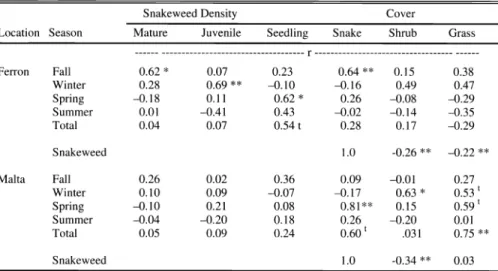
Fig. 1. Snakeweed cover and annual precipitation at Ferron, Ut. (error bars are SE). Average annual precipitation was 22 cm.
At Ferron, density of broom snakeweed age classes, and cover of snakeweed and associated forage classes (shrubs and grasses) was analyzed by the Mixed pro- cedure ANOVA in a repeated measures design using the compound symmetry covariate structure, comparing sites, exclosures (grazing vs no grazing), and years. At Malta, data were analyzed by a similar model comparing macro plots and years. Correlations were made between broom snakeweed cover and density of each age class with seasonal precipitation for the current water year, and also lagged
precipitation from the previous year.
Correlations were also made between cover of snakeweed and shrub and grass cover at both locations.
25
20
dResults Ferron, Ut.
There was no difference between the 2 Ferron sites in broom snakeweed cover or density (p > 0.22). There was no differ- ence in these parameters between the exclosures and grazed areas (p > 0.21), indicating that grazing in early spring had no effect on the snakeweed population at this location during this 13 year study.
There were differences among years (p <
0.0001) and some correlations with sea- sonal precipitation (Table 1).
The correlation between snakeweed cover and total precipitation was not strong (r = 0.28, p = 0.34 for current year,
1994 1996
Year Fig. 2. Density of snakeweed age classes at Ferron, Ut.
Mature Juvenile Seedling
(Table 1), but the trends were similar for the first part of the study (Fig. 1). The snakeweed population was highest when the study began in 1987, which coincided with the wet years of 1987 and 1988.
Precipitation was below average in 1989 and 1990, and the snakeweed population declined and completely died out in 1990.
Precipitation increased to about average in 1992 and then increased to 50% above average in 1995, with snakeweed cover continuing to increase. Both precipitation and snakeweed cover declined in 1996.
Precipitation was very high in 1997 and 1999, but snakeweed cover increased only slightly, thus causing the divergence and resulting low correlation. The snakeweed population died out again in 2001.
Density of snakeweed age classes increased following the 1989-90 drought (Fig. 2). Juvenile plants appeared in 1992 following above average winter precipita- tion (r = 0.69, p = 0.01) and survived and grew into about the same number of mature plants in 1994. Most of these mature plants died back in 1996 in response to the drop in the previous fall precipitation ( r = 0.62, p = 0.02). The seedling stage did not appear in this cycle.
Perhaps germination occurred following abundant late summer rains in 1991 and plants were established as juveniles when measured in June 1992. There was a large influx of seedlings in 1995 that corre- sponded with high spring precipitation that year (r = 0.63, p = 0.02). Few of these seedlings survived due to the low precipi- tation in 1996 (Fig. 2).
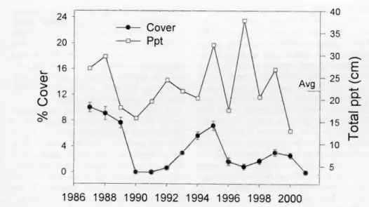
There was a weak but significant nega- tive correlation between cover of snake- weed and other shrubs (r = -0.22, p = 0.003), and between snakeweed and grasses
(r = -0.26, p = 0.0006), particularly curley grass (Fig. 3). Cover of grass and shrubs increased in 1991 and 1992 when snake- weed populations were down, then declined as snakeweed increased in 1994 and 1995.
Snakeweed cover declined in 1996 and 1997, and grass cover subsequently increased from 1998 to 2001, in spite of average or below average precipitation.
Malta, Ida.
The snakeweed population was highest when the study began in 1990 (14%
cover), declined to 6-10% cover from 1992 to1999, then nearly died out in 2001 (year effect p < 0.001) (Fig. 4). Snake- weed cover was correlated with total annual precipitation (r = 0.60, p = 0.06), and particularly with spring precipitation
(r= 0.81,p=0.004).
408 JOURNAL OF RANGE MANAGEMENT 55(4) July 2002
1986 1988 1990 1992 1994 1996 1998 2000
YEAR
Fig. 3. Cover of snakeweed in relation to grasses and shrubs at Ferron, Ut. (error bars are SE).
There was a progression through the snakeweed age classes (Fig. 5 ) and some recruitment of new plants into the popula- tion. Seedlings were very abundant in 1993, corresponding to the high spring pre-
cipitation that year. Another crop of seedlings grew in 1994. A few seedlings apparently survived and progressed into the Juvenile category in 1994, and about half of the 1994 seedlings progressed to Juveniles and peaked in 1995. There was a slight increase in the number of mature plants in 1996, indicating the progression of some juveniles into the mature stage. Although there appears to be relationships between seedlings, juveniles and precipitation, cone- lations were not significant (P > 0.05).
Grass, sagebrush, and snakeweed cover followed precipitation patterns during the first part of the study; increasing in wet years and declining in dry years (Fig. 6).
Towards the end of the study, sagebrush cover continued to increase as snakeweed cover declined. There was a negative cor- relation between sagebrush cover and snakeweed (r = -0.34, p = 0.0001) sug- gesting that increasing sagebrush was reducing snakeweed. Grass cover appears to be more affected by total precipitation (r = 0.75, p = 0.01) than competition from snakeweed or sagebrush (Table 1).
and increasing in seasons of abundant pre- cipitation. Snakeweed population cycles in the Southwest have also been associated with climate patterns (Pieper and McDaniel 1989, McDaniel 1989, Beck et al. 1996, 1999, McDaniel et al. 2000 ).
McDaniel and Ross (2001) followed 2 snakeweed populations for 20 years. A severe regional drought occurred during the summer of 1980, causing a significant die off of snakeweed plants at Vaughn, N.M., but snakeweed plants survived at Roswell, N.M., less than 80 km away.
The following spring of 1981 had twice the average precipitation, and snakeweed
18 16 14 12 10 8
6 4 2
Discussion
Snakeweed populations in our study cycled on the Colorado Plateau and Snake River Plains; dying back during drought
seedlings established at both locations and grew into uniform, even-aged stands. Most snakeweed plants were killed at Roswell by root borers (Crossidius puchellum) in 1987-88 and the site remained free of snakeweed. The Vaughn population declined in the early 1990's and has remained low. They concluded that micro environmental factors unique to each site determined germination, establishment and death of the respective populations, independent of the broad regional climatic patterns.
The micro environmental factors gov- erning snakeweed germination, establish- ment and death have been described.
Broom snakeweed is a short-lived perenni- al that propagates by seed in years of opti- mal environmental conditions, and dies out from drought stress or insect damage
.It is a prolific seed producer ranging from
2036-3928 seeds/plant (Wood et al.
1997). Seed are dispersed over winter, mainly during high winds and snowfall, and most seed fall near the parent plant.
Seed viability remains high over winter (70 - 80%) but drops to 0 in late May and June, suggesting that seed remaining on the soil surface degrade rapidly.
Germination is stimulated by light, tem- perature and soil moisture. Seeds must remain partially exposed on the soil sur- face (Mayeux 1983) with alternating day/night temperatures 15 and 30° C (Mayeux and Leotta 1981). Germination depends on saturated surface soil moisture for at least 4 days (Wood et al. 1997), requiring > 25mm precipitation that keeps the soil surface wet for several days.
Mortality of seedlings was > 70 % the first
1990 1992 1994 1996 1998 2000
0
Fig. 4. Snakeweed cover and annual precipitation at Malta, Ida. (error bars are SE). Average annual precipitation was 27 cm.
JOURNAL OF RANGE MANAGEMENT 55(4) July 409
1992 1994 1996
Year
1998