Municipal infrastructure asset management systems: state-of-the-art review
Halfawy, M.; Newton, L. ; Vanier, D.
NRCC-48339
A version of this document is published in / Une version de ce document se trouve dans: CIB W78 Conference on Information Technology in Construction,
Dresden, Germany, July 19-22, 2005, pp. 1-8
Municipal Infrastructure Asset Management Systems: State-of-the-Art
Review
M. Halfawy, L. Newton & D. Vanier
Institute for Research in Construction, National Research Council, Canada
ABSTRACT: Significant advances have been made during the last decade in developing infrastructure asset management systems. However, there is an obvious need to extend the scope and capabilities of these systems to better support the sustainable development and management of infrastructure assets. This paper provides a state-of-the-art review of municipal infrastructure asset management systems currently available, and dis-cusses the evaluation process of a number of commercial-off-the-shelf (COTS) software systems. The main features, capabilities, and limitations of the evaluated software are presented. The main objective of the paper is to provide asset management organizations with an objective review of these systems, and to identify areas where further research and development are needed.
1 INTRODUCTION
A municipal asset management system is used to store and manage asset data, and to support opera-tional and strategic decision making processes. Mu-nicipal infrastructure asset management systems are used for land and property management, facilities and infrastructure management, and utility manage-ment. Danylo and Lemer (1998) envisioned the role of an asset management system as “an integrator, a system that can interact with and interpret the output coming from many dissimilar systems.”
Many new techniques and software solutions have been developed during the last decade in an at-tempt to improve the infrastructure asset manage-ment process. Significant advances have been made in developing software tools to support activities in various domains, such as pavement and bridge man-agement, sanitary/storm water sewer manman-agement, and water supply management.
The Municipal Infrastructure Investment Plan-ning (MIIP) project is being carried out by a consor-tium of researchers from the National Research Council Canada (NRCC) and ten collaborating mu-nicipalities/organizations from across Canada. The goal of the MIIP project is to develop and formalize a generic framework and decision support tools for collecting and storing information and knowledge related to prominent issues in sustainable infrastruc-ture asset management.
One of the objectives of the MIIP Project is the development of a roadmap that identifies areas where further research and development are needed. In accomplishing this objective, it was necessary to
evaluate the current state-of-the-art represented by a wide cross-section of commercially available soft-ware solutions. This paper does not rate or rank the packages evaluated herein, but aims primarily to provide asset managers with an objective review of systems, and to identify areas where further research and development are needed.
2 GENERAL-PURPOSE VS. ASSET-SPECIFIC SYSTEMS
Asset management software can be classified into two broad categories: general-purpose software and asset-specific software. General-purpose systems typically offer generic functionality that need to be customized and adapted for specific data and work processes related to specific classes of assets. Asset-specific software solutions provide a set of built-in data models and processes to support the manage-ment of a specific class of municipal assets (e.g. fa-cilities, sewers, roads, bridges, etc.).
The main functionality provided by general-purpose software systems is the management of as-set data using a Relational Database Management System (RDBMS). Add-on modules of the underly-ing RDBMS are developed to support a wide range of additional asset management functionality such as data management, work management, and procure-ment. They also support a range of data im-port/export options, and the capability to interface with other software (e.g. CAD or GIS systems).
General-purpose software are not currently widely used in municipalities mainly due to the large
installation and start up cost, the need for specialized expertise to set up and customize these systems to the processes of specific municipalities, and the high operational and maintenance costs of these systems.
Asset-specific software solutions implement specific data and process management procedures that are required to support the management of cer-tain classes of infrastructure assets. A significant number of asset-specific software systems have been developed during the past decade. Examples of these systems include pavement management systems, bridge management systems, sewer management systems, and facilities management systems. A number of asset-specific systems are also available as Commercial-Off-The-Shelf (COTS) products for managing buildings, water distribution systems, sanitary and storm water sewers, pavement, among others. These applications typically use an RDBMS to support the development and maintenance of the asset inventory database. Many applications provide built-in GIS capability or support interfacing with other commercial GIS software.
Asset-specific software solutions extend the data management functionality by implementing procedures for estimating and measuring the per-formance level of a particular infrastructure asset based on the physical and condition data. An exam-ple of software in this class includes systems devel-oped for condition assessment and rating of sewers based on Closed Circuit Television (CCTV) inspec-tion, such as Flexidata (www.flexi-data.com) or CIMS (www.cobratech.com).
3 THE SOFTWARE REVIEW PROCESS
A representative sample of infrastructure manage-ment software systems has been selected for detailed evaluation. The selected systems cover a wide spec-trum of software capabilities and scope, as they are currently available by COTS software. Due to space limitations, this paper only provides highlights of the evaluation process, focusing on the features, capa-bilities, and limitation of these systems. A more de-tailed description can be found in Vanier et al (2005). The systems presented in this paper are: Synergen; CityWorks; MIMS; Hansen; RIVA;
Infra-structure 2000, and Harfan. The information
pro-vided herein is based on trial versions obtained di-rectly from the developer and represents the most current version of the software, or they are based on literature surveys and demonstration of the software.
3.1 Synergen
Synergen is a web-based work management and pro-curement system that is mainly targeted to large organizations with extensive data and process man-agement requirements. According to the taxonomy of asset management systems described in Section 2,
Synergen can be classified as a general-purpose sys-tem. Synergen defines a set of applications organ-ized in a hierarchy of subsystems and modules. The subsystems include: Resources, Maintenance, Pur-chasing, Inventory, Customer, and Administration. The Resource subsystem provides common data management functionality needed by all other sub-systems. The Resource data include items such as assets, accounts, inventory, personnel, etc. Each of the five other subsystems represents an area of func-tionality that is typically supported by a municipal department. The Maintenance subsystem supports work management functions; the Purchasing subsys-tem supports procurement and contracting proc-esses; the Inventory subsystem supports the track-ing, ordertrack-ing, and receiving of parts and equipment needed for maintenance operations; the Customer subsystem maintains customer data and service re-quests; and the Administration subsystem manages the set up and customization parameters of the entire software.
A module represents a group of functions that can be accessed through a set of “Views” or forms to display and edit the data records selected by the user. A module roughly corresponds to a “table” in a relational database, where each View or form dis-plays a subset of the fields in that table. For exam-ple, the Asset module in the Resource subsystem would correspond to an Asset table in the database, where each record in the table represents an asset, and each View displays a group of the data fields that are related to a particular aspect of the Asset re-cord, such as Manufacturer data, Cost, Operational data, Work history, Depreciation, etc.
In addition, each module defines a set of “Ac-tions” that represent data manipulation and analysis functions, or a procedure that a user may need to perform while in a particular module. Some actions, such as search for records that satisfy multiple crite-ria, modify search critecrite-ria, and display or save search results, are generic in nature, and therefore, are common to all modules. However, some actions are module-specific, such as the actions for creating or updating work orders in the Work Order Module.
Synergen includes extensive data import/export capabilities, and can interface with external applica-tions such as GIS, email, or Supervisory Control and Automatic Data Acquisition (SCADA) systems. Figure 1 shows a screen capture that displays the Asset default View, and a list of other Views and Actions in the Asset module, in the Resource Sub-system. The figure also shows Synergen GIS inter-face.
Due to its general-purpose nature, Synergen can be customized and configured to manage assets in virtually any organization. However, the set up and customization process and the investment required may be significant, especially for small to medium size organizations. In the long run, the rewards of
using the system may prove to outweigh that in- vestment for smaller municipalities.
Figure 1. Synergen Asset module in the Resource subsystem, and GIS view of selected assets (Courtesy of Synergen).
3.2 CityWorks
CityWorks is a GIS-based solution for operational and maintenance management of municipal assets. CityWorks supported functions including asset data management, work order management, recording in-spection and condition data, and report generation. It also supports logging and tracking of service re-quests using the add-on “Call Center” module, and supports procurement and inventory management operations, using the “Storeroom” module. City-Works includes several built-in spatial data models based on the schemas defined by ESRI (ESRI 2005). The models support a wide range of municipal assets such as water, wastewater, storm water, and road networks. Users can modify or override the schemas to suit the specific requirements of their organiza-tions. Figure 2 shows the ArcGIS add-on showing a map of water mains and associated work orders.
A distinguishing feature of the software is its tight integration with GIS. Unlike most of other ap-plications, CityWorks uses the GIS database (or geodatabase) to maintain and integrate asset data. This approach of using a single centralized database has the advantage of ensuring the consistency of as-set data, and eliminating the need to duplicate the data in multiple databases or to update different da-tabases to keep the data synchronized.
CityWorks can be deployed as an extension to ESRI ArcGIS or as a stand-alone system. The data-base managed by both versions have the same
geo-database schema, and therefore, both versions can co-exist and be used by different teams in an organi-zation, depending on whether a GIS interface is re-quired. CityWorks also offers the capability to spa-tially link work orders and service requests to specific assets or to street addresses. The first ap-proach would be useful for municipalities that al-ready maintain a GIS asset inventory, while the sec-ond approach was designed for municipalities that have incomplete asset inventory to be able to link work orders and service requests to street addresses. When the complete asset inventory is developed at a later stage, these addresses can then be processed and associated with the physical assets instead. A useful feature of the software is the link it maintains between the assets and street addresses. This link would facilitate the identification of customers who may be affected by an asset failure or a planned maintenance operation, and the provision of proper notices to these customers.
A distinguishing feature of CityWorks is its abil-ity to support field operations by enabling browser-based wireless access (using a PDA device) to the asset geodatabase, and allowing field staff to access and update work orders and service requests, and to view asset maps. The DataPump module enables field staff to run CityWorks in a “disconnected” mode by checking data in and out of the database, and keeping the data synchronized between sessions. Another module, called Inbox, routes work orders and service requests assigned to responsible
person-nel, and enables them to locally or remotely access these work orders.
Figure 2. CityWorks ArcGIS add-on showing a map of water mains and associated work orders (Courtesy of Azteca).
3.3 Municipal Infrastructure Management Systems (MIMS)
The Municipal Infrastructure Management System (MIMS) is primarily a data management system for water, wastewater, storm water, and road networks. It also includes modules for managing gas pipelines and municipal buildings. The system is targeted to small and medium size municipalities. MIMS has extensive data import/export and reporting capabili-ties, and incorporates a wide range of pre-formatted reports. MIMS provides the users with a consistent set of forms and tools for managing different infra-structure assets.
Each class of assets is broken down into its main components, which are in turn subdivided into asset types. Each asset type is roughly represented as a ta-ble in the underlying relational DBMS. For example, the water, sanitary and storm water network asset classes are broken down into lines, features, facili-ties, and equipment components, and the lines com-ponent is subdivided into pressure mains, gravity mains, service/leads, and channels asset types. Fig-ure 3 shows a screen captFig-ure that displays the main form of the four main asset classes.
MIMS implements its own GIS functionality through the use of ESRI MapObjects. The GIS com-ponent provides access to the asset maps and data-base, and maintains a link between asset IDs and spatial features’ IDs. It also includes a “Data Qual-ity” wizard that allows users to identify missing
links between assets and spatial features. Users can navigate through the map using typical GIS viewing functions. Users can perform spatial queries to lo-cate assets relative to a user-defined shape or to cre-ate thematic maps based on selected asset attributes (e.g. asset condition rating). Users can retrieve an asset record using the Find tool, where users can search for assets satisfying multiple criteria, and ac-cess the asset record or view the asset location on the map.
For each asset type, MIMS supports five main functions, which can be accessed from the asset data form. The “Locate” function activates the Map Viewer and zooms to the location of the current as-set. The “Costing” function enables users to record cost data related to the asset. The “Functional Ade-quacy” function allows users to rate the overall per-formance and the level of service delivered by the asset (good, fair, or poor) for later use in the mainte-nance planning and prioritization process. The “Condition” function allows users to rate the condi-tion of the asset using a consistent standard for as-sessing the structural condition of the asset.
3.4 Hansen
Hansen is a major application developed by Hansen Information Technologies to provide capabilities for managing government operations including asset and property management, utility billing, permits, financial and human resources management. It in-cludes inventory collection, valuation, determination
of deferred maintenance, condition assessment, es- maintenance and rehabilitation (M&R) options. timating remaining service life and prioritizing
Figure 3. MIMS MapViewer and forms for managing water, sanitary, storm water, and roads networks (Courtesy of MIMS).
Hansen is client-server application installed on individual desktops. Interfaces written by Hansen to allow data import/export include the GeoMedia-Hansen Interface and Integrated Map Viewer, which allow a GIS link to Intergraph and ESRI applica-tions. Other software interfaces include those for Flexidata and CIMS sewer condition assessment software. The next version of the product, will be web-based, thus eliminating the need for most inter-faces and desktop installation. Hansen applications are typically used by medium to large organizations.
Hansen’s asset management tools include two main modules: Public Works solutions and Trans-portation solutions. Each module is GASB State-ment 34 compliant with an asset specific infrastruc-ture accounting model. The Public Works module contains divisions for: industrial waste management, parks management, plant and fleet management, street management, water and wastewater manage-ment, and works management. The Transportation module contains: bridge management, facilities and equipment, inventory management, pavement man-agement system, property manman-agement, railway management, roadway management, sign manage-ment, street managemanage-ment, and work management.
Hansen provides a detailed asset inventory and valuation capability using one or more of the follow-ing asset data models: hierarchical, directional, pres-surized, segmented, point, area, linear and network.
Hansen does not have an extensive condition as-sessment capability. Only the pavement manage-ment system sub-module has integral condition assessment tools including deterioration curves and decision models. Other condition assessment data are fed into the Hansen database through compliant applications such as Flexidata and CIMS. The user can define condition rating criteria within Hansen and obtain asset conditions. Activity based costing, and budgeting and planning capabilities in the Transportation module appear to allow for prioritiza-tion of M&R activities. It was not clear from the product literature if this capability extended to multi-year asset management. Hansen has recently teamed up with RIVA (Section 3.5) to use RIVA’s long-term asset management capabilities to extend Hansen’s operational management functionality. Figure 4 shows sample screens displaying elements of the public works and transportation modules.
3.5 RIVA
RIVA (Real-time Asset Valuation Analysis), devel-oped by Loki Innovations (www.loki.ca), provides capabilities for long-term asset planning in a 10 to 200 year planning horizon. RIVA is a web-based application that can interface with most common ap-plications. The data can come from any ODBC-compliant source so the user can pull data from other
databases, such as Hansen. It supports inventory
data collection, valuation, determination of deferred maintenance, condition assessment, estimating re-maining service life (RSL) and asset prioritization.
Figure 4. View of Hansen demo screen showing Property Browser from Public Works and Transportation modules.
RIVA has a modeling capability that can be used for valuation, determination of deferred mainte-nance, condition assessment, estimating remaining service life and prioritizing M&R. Deterministic and probabilistic models can be created using formulae set up by the user or with help from Loki. The For-mula Builder allows the user to create, change and test the formulae that drive calculations and models. Models can be trial models, in which the user can vary the model parameters to undertake a compari-son of various asset management scenarios, or cor-porate models. Changes made to the models are automatically reflected in data and model outputs e.g. deterioration curves, priorities, etc.
The asset inventory and valuation capability within RIVA can retrieve information already in the user’s existing databases and permit the user to set up new asset classes. This allows the user to begin using the application almost immediately. The appli-cation supports the definition of unlimited number of asset classes. The hierarchical structure allows the user to specify the level of data detail required for each asset. This enables the user to drill down through the asset from city-level to street to compo-nent. The asset inventory can be viewed both geo-graphically and by asset “silos” for any level of de-tail. RIVA has a built-in valuation capability that uses integrated economic factors to value assets. These factors can be amended by the user if desired. RIVA supports both ESRI and Intergraph GIS appli-cations. Figure 5 shows the GIS integration capabili-ties of RIVA and the ability to rollup costs to a net-work level to demonstrate the long-term impact of infrastructure funding on cumulative shortfalls.
The deferred maintenance capability within RIVA is also user defined. The user defines “best practices” and RIVA calculates the level of deferred maintenance based on a set of events triggered by the practice. The application allows modeling to see the impact of various M&R strategies on the size of the maintenance backlog. In modeling the data, the user is able to vary economic factors such as rate of
expenditure (% per annum), discount rate, etc. RIVA is not a work order system but it can import work order data and allow the user to access these data.
RIVAcan import condition assessment data from
other sources and directly link them to assets at any level of detail. The application allows the user to set up models, based on user-defined parameters or on pre-existing systems (e.g. Water Research Centre-WRc), to determined asset condition. RIVA allows the user to compare condition and shortfall adjusted condition to show the impact of deferred mainte-nance and maintemainte-nance strategies. Any condition as-sessment tool and any scoring metric can be used, and can have the resulting data incorporated into RIVA for analysis and modeling. An important part of asset condition is to know the estimated RSL. In RIVA, user defined RSL models allow users to vary parameters such as M&R strategies to estimate RSL. RIVA has the capability to set priorities within classes and across all assets, which enables users to harmonize priorities and generate an event priority list. RIVA’s “thin client” architecture means that new features can be added seamlessly.
3.6 Infrastructure2000
Infrastructure2000, developed by Vanasse Han-gen Brustlin Inc, provides capabilities for asset man-agement planning, and is targeted to small to me-dium size organizations. Infrastructure2000 is client-server application installed on individual desktops. It supports inventory collection, valuation, determina-tion of deferred maintenance, condidetermina-tion assessment, estimating remaining service life and prioritizing maintenance and rehabilitation. The software can be integrated with popular GIS applications such as Ar-cGIS. Other interfaces and custom applications can be created to convert data to a compatible format.
Infrastructure2000 consists of RoadManager, with five modules, and the following work manage-ment tools: WorkManager, Equipmanage-mentManager, and PermitManager.
Figure 5. View of RIVA showing long-term impact of infrastructure funding.
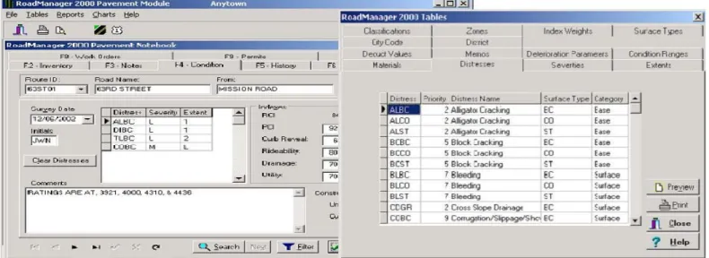
The RoadManager modules are: Pavement, Side-walk, Traffic Control, Drainage/Utility, and Budget Analysis. The Pavement, Sidewalk and Drain-age/Utility modules provide a detailed inventory and valuation capability. The pavement module provides a condition assessment capability using the standard rider comfort index (RCI) or the pavement condition index (PCI). The 0–100 index score is mapped to a condition score where “one” is defined as a “do nothing” intervention and “five” is defined as a “re-construct” intervention. This module also includes a GASB 34 notebook. The remaining modules are not based on established condition assessment protocols. Other asset classes such as bridges, structures, chan-nels, and pipes are included in the Drainage/Utility module. The Budget Analysis module provides the capability to define repair alternatives, create and compare funding scenarios, and define and view de-terioration models. This can only be accomplished for pavement assets, however. Figure 6 shows a sample screen demonstrating the pavement module notebook and table options.
3.7 Harfan
Harfan’s method is geared to be a generic solution for municipalities. It attempts to be flexible in its de-sign so that it can be adapted to support: (1) extend-ing the asset service life, and (2) optimizextend-ing the long-term investments. The software can be applied to diverse areas, such as water and sewer networks, roads, gas and telecommunications networks, elec-tricity networks, street lighting, buildings, marine assets, airports, and rail systems. It is possible at the upper levels of the data structure to drill down to the basic level of inventory data and search for informa-tion. Harfan uses an Oracle RDBMS and allows one-way integration with popular GIS systems (e.g. Ar-cGIS and MapGuide).
Harfan philosophically recommends a five-step methodology that addresses typical asset manage-ment issues such as: what do you own, what is it worth, what is the condition, what is the remaining service life, how much should you invest to ensure sustainability, and what needs to be done and when. As a result, the software modules are designed to produce answers to these questions.
The inventory module is the data warehouse that permits both the design of the input forms for the data storage, and the entry and retrieval of relevant data. The condition assessment module allows users to select an existing assessment protocol or to define their own protocols. For example, a weighted factor method can be used to assign weights to a variety of assessment metrics to produce a physical, functional, sustainability and global index. Typically infrastruc-ture assets with similar physical and functional prop-erties can be lumped together as “families of behav-ior” for the purpose of harmonizing future condition.
The service life prediction module uses determi-nistic curves selected by the user to calculate the remaining service life. An interactive program to develop “decision trees” is available to the user; this rule-based decision tree can then be used to suggest the most appropriate renewal strategy given condi-tion, service life, maintenance strategy, funding lev-els, etc. The maintenance prioritization module can produce multi-year capital improvement plans based on analysis of existing data. Techniques such as weighted factor method are used to prioritize the in-frastructure projects; however, other decision priori-tization methods are currently under consideration. The software permits the user to select and compare different renewal options. Figure 7 shows a screen capture of integrated capital plan and the resulting Global Condition 10 years into the future, after hav-ing applied a scenario of roughly $22.4 million of rehabilitation and reconstruction works.
Figure 6. Sample screens from RoadManager showing the Pavement module notebook and table options.
Figure 7. Harfan Integrated right-of-way 10-year Capital Plan.
4 CONCLUSIONS
This paper presented a review of a number of COTS municipal infrastructure asset management systems. The main features, capabilities, and limitations of the evaluated software were briefly discussed. The evaluated software comprised seven well-known systems available in North America that are com-monly used by municipalities, and that constituted a representative sample of the available systems.
Although the majority of asset management tems supported interfacing with GIS, very few sys-tems could support integration with Enterprise Re-source Planning (ERP) or financial software systems. Historically, ERP systems have been the main source of financial and personnel data, and the need to link asset management systems to these data sources is a critical step towards supporting long-term asset management strategies.
In light of the software review results, some di-rections for future research can be identified. Of par-ticular interest is the development of methods and tools for long-term renewal planning of infrastruc-ture assets. The vast majority of the existing systems
focus primarily on supporting the operational day-to-day management activities, and an extremely small number of software tools implemented a lim-ited support for long-term renewal planning. Also, many fundamental asset management functions, such as performance modeling, and maintenance prioritization, are not supported by most of these ap-plications.
Developing industry wide standard data models for infrastructure systems is another critical area for future research. The data models supported by exist-ing software are mostly proprietary, which impedes the ability to share and exchange asset data. Stan-dardizing the data models would enhance the role that the systems can play to enable better integration of the management processes, and the interoperabil-ity between various software applications.
5 ACKNOWLEDGEMENT
The authors would like to acknowledge the support of the MIIP consortium and the Natural Science and Engineering Research Council of Canada (NSERC). REFERENCES
CityWorks, www.azteca.com (Last accessed: May 15 2005)
Danylo, N. and Lemer, A., “Asset Management for the Public Works Manager: Challenges and Strategies, Findings of the APWA Task Force on Asset Management,” 1998.
Hansen, www.hansen.com (accessed: May 15 2005)
Harfan, www.harfan.com (accessed: May 15 2005)
Infrastructure2000, www.infrastructure2000.com (accessed:
May 15 2005)
MIMS, www.albertamims.org (accessed: May 15 2005)
Real-time Infrastructure Valuation Analysis (RIVA),
www.rivaonline.com (accessed: May 15 2005) Synergen,
www.splwg.com/solutions/SYNERGEN/synergen.asp (ac-cessed : May 15 2005)
Vanier, D., Newton, L., and Halfawy, M., “Investment Plan-ning Software Review”, Client Report B-5123.9, to appear.