Available Online atwww.ijcsmc.com
International Journal of Computer Science and Mobile Computing
A Monthly Journal of Computer Science and Information Technology
ISSN 2320–088X
IMPACT FACTOR: 6.017IJCSMC, Vol. 6, Issue. 7, July 2017, pg.56 – 63
Void Node Problem Handling Three
Dimensional Geographic Routing For WSNs
Dr. P. Sengottuvelan
1, P. Sathya
21Associate Professor, Department of Computer Science, Periyar University PG Extension Centre, Dharmapuri - 636705, INDIA
(phone: 04342-230399; e-mail: [email protected])
2Ph.D Research scholar, Department of Computer Science, Periyar University PG Extension Centre, Dharmapuri - 636705, INDIA
(phone: 04342-230399; e-mail: [email protected])
Abstract: One of the most significant concerns in the maneuver of Wireless Sensor Network (WSN) is the real-time data delivery. It is mainly proposed for wireless network and based on the idea that the source sends a message to the geographic location of the destination instead of using the network address in three dimensional spaces have been provided to lift up the effect of long route and spares regions on assurance of real-time data delivery. Geographical routing protocols (GRPs) are promising candidates in fulfilling such real-time requirements because they can handle dynamic changes in the network far better than topological routing protocols, which in turn enable GRPs to maintain the delay deadlines effectively. 3DRTGP are deliberate to fit with WSNs that are deployed in 3D space. 2D-RGRP and 3D-RGRP are evaluated based on two metrics, which are packet miss ratio and packet E2E delay.
Key Terms: Geographic routing protocols, 3DRTGP, Packet miss ratio, Packet E2E delay.
I. INTRODUCTION
power resources. This chapter discusses examples of some of WSN applications, challenges in WSNs, problem statement, and contributions of this dissertation.
II. RELATED WORK
Routing Protocol Categorizes
In literature, a large number of routing protocols have been proposed to solve multi-hop routing problem [1]. Some of the most common routing protocols include: geographical routing protocols (GRPs) and topological routing protocols (TRPs).
Geographical routing protocol
GRPs rely on the location information to propagate the data from a given sensor node to the BS or sink. GRPs have gained popularity in WSNs because of their low overhead, low operation complexity, and smaller E2E delay than TRPs.
GRPs do not require route maintenance and discovery schemes like TRPs; therefore they can handle dynamic changes in the network much better than TRPs. The main weakness of GRPs is their dependence on the location information. However, this deficiency can be resolved using location services such as Global Positioning Systems (GPS), radio ranging [2, 3], and other localization techniques [4]. In general, GRPs can be classified into two dimensional GRPs (2D-GRPs) and three dimensional GRPs (3D-(2D-GRPs):
A. Two dimensional geographical routing:
In 2D-GRPs, the sensor nodes are assumed to be deployed on flat surface. That means the third coordinate of sensor locations are discarded in this kind of protocols and all sensors are projected on a surface [1]. This assumption is justified for applications where sensor nodes are deployed on ground or where the hight of the network is smaller than the transmission range of sensors.
B. Three dimensional geographical routing:
In real-life applications of WSNs, sensor nodes are deployed in a three dimensional (3D) space such as, application in ocean monitoring , forest fire sensing , mining and unmanned aerial vehicle (UAV) networks [5]. For such applications, GRPs must utilize three dimensional location information for accurate operation. Even if two dimensional GRPs can function in 3D space, they do not utilize the full potential of the network.
For instance, in a dense network, there will be more packet forwarding than necessary, which causes packet collisions, congestions and premature energy depletions. Experimental results presented in demonstrate that excluding the third dimension from GRPs can significantly reduce reliability of the protocols.
Topological routing protocol
TRPs count on routing table construction in every sensor node. Routing table contains all possible routes from any given node to the BS. Constructing such routing tables entail a large amount of exchanging beaconing messages, which incur WSN more energy and time delay. Exchanging messages dramatically affects the network performance and causes congestion and collision. For this reason, topological routings are not scalable to the frequent changes in network. For this reason, topological routing approach cannot be acceptable solution for time sensitive applications [6].
Void Node Problem
1. Real-time Routing Protocols
There are large number of real-time applications [8]that entail data packets to be delivered within limited time with minimal overhead and high reliability. There are two classes of real-time routings: hard real-time and soft real-time routing protocols.
2. Hard real-time routing protocols
In this class of real-time routing approach, the arrival of the packets after their deadlines are considered failure of the routing protocol [9] and such packets are discarded. The objective of hard real-time protocols is to ensure that all packets meet their deadlines. Nuclear systems and seismic applications are examples of hard real-time applications.
Soft real-time routing protocols
In this class of real-time routing, the deadlines of the packets are probabilistic and the delay of the packet is tolerable. The main goal of these proto- cols is to optimize some application specific criteria. For example, maximizing the packet delivery ratio, maximizing the number of packets that meet their deadlines and average energy consumption per packet. In this dissertation, soft real time routing protocols are considered.
III. THREE DIMENSIONAL REAL-TIME GEOGRAPHICAL ROUTING PROTOCOL (3DRTGP)
Delivering data in real-time has become essential for wireless sensor networks (WSNs) due to emerging time sensitive applications such as in smart grid, industrial control and process automation. Geographical routing protocols (GRPs) are promising candidates in fulfilling such real-time requirements because they can handle dynamic changes in the network far better than topological routing protocols, which in turn enable GRPs to maintain the delay deadlines effectively [11,1]. Another significant advantage of GRPs is lower network overhead as compared to topological routing protocols since GRPs do not require route discovery and maintenance procedures. The main weakness of GRPs seems to be their dependence on accurate location determination. However, this deficiency can be resolved using location services such as Global Positioning Systems (GPS), radio ranging, and other localization techniques.
In real-life WSN applications, sensor nodes are deployed in three-dimensional (3D) space, but the majority of GRPs consider a two-dimensional (2D) coordinate system. This exclusion of the third dimension from routing interferes with the effectiveness of GRPs, which has prompted 3D GRP proposals. However, existing 3D GRPs are not designed to support real-time data transfer and do not provide a viable solution to the 3D void node problem (VNP) . This problem has significant impact on the network performance, VNP occurs when the packet arrives at a node that does not have any neighbor that can forward the packet to the destination.
Figure1: Functional diagram of 3DRTGP.
DRTGP PROTOCOL DESIGN
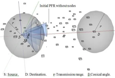
In the design of this protocol, it is assumed that a WSN consists of η number of uniformly randomly distributed homogeneous nodes. These nodes are stationary and are deployed in a 3D volume of V. It is assumed that the transmission range is r and is radiating spherically. 3DRTGP, being a GRP, assumes that every node knows its own location, and the source nodes know the location of their destination node. In most WSN deployments, the destination (or base station) node is located in a predefined position and this location information can be preprogrammed to all sensors.
One of the objectives of the proposed protocol is to form an adaptive optimal conical PFR. Forming this PFR
captures the essence of using the third dimension. With an optimum PFR, the number of forwarding nodes will be reduced and forwarding will be restricted to a smaller volume, which reduces congestion and ultimately helps the protocol to meet delay deadlines. The functional diagram of 3DRTGP and these functions are given as follows:
Location management.
Forwarding management.
VNP handling.
Flooding reduction.
The forwarding management function decides if the node forwards the packet or not according to its forwarding matrices. The location management function determines whether the node is located in the PFR or not. VNP handling is responsible for identifying if the node experiences a void region and activates the VNP handling algorithm to divert the traffic to an alternative PFR. VNP can be also experienced if the nodes in the PFR are congested and cannot meet the packet deadline. For this reason, VNP handling is important in selecting alternative routes to meet the delay deadlines necessary for real-time operation. The flooding reduction function identifies if the received packet has already been broadcast or not. Descriptions of these functions are provided in the following subsections.
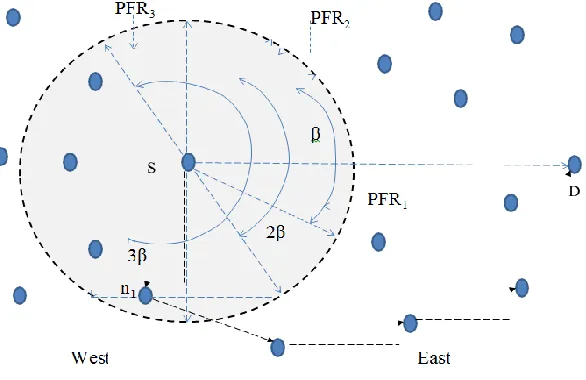
general, VNP does not occur if there is at least one node in the PFR. The probability of having no node in the PFR is denoted by q, for a given β.
Figure 2 PFR with and without nodes
Figure 3: Probability of VNP: analytical and experimental calculated based on 3.1.
The VNP handling function is triggered when a sender does not overhear the transmitted packet within a predefined waiting time, τw. The packet may not be forwarded because of the following two cases: a) the PFR does not have any node or b) nodes in the PFR are congested and cannot meet the delivery criteria. If there is a VNP, the sender has to rebroadcast the same packet. This time, the nodes that overhear this rebroadcast will double their β and check whether they are now located inside the newly formed PFR. This process will enable a new set of nodes in this wider PFR to participate in packet forwarding. Such PFR adaptation is done locally at each node and β is set to this new value at the nodes through- out the operation. If there is still no forwarding after this rebroadcast, then the sender waits for another τw duration before rebroadcasting again and the receiving nodes will extend their PFR to be even wider.
Figure 4:Illustration of VNP in 2D
This adaptive process continues until the packet is forwarded successfully by a forwarding node and resolves
VNP as long as there is no network partitioning around the sender in the network. If β becomes large enough to contain the previous hop sender, then the previous hop sender assumes responsibility for the packet transmission. Fig. 2 illustrate the process of VNP handling in 2D.
Flooding Reduction
Flooding reduction is important to reduce the amount of retransmissions in WSNs and ad hoc networks. Generally, in protocols based on flooding there is an implosion due to the transmission of duplicated packets by many neighboring nodes. Such indiscriminate forwarding can cause collisions, congestion and battery depletion in WSNs. In order to avoid this problem, the sender drops the previously broadcast packets by itself. Dropping the packets that have already been broadcast prevents packet looping.
Table 1 SIMULATION PARAMETERS OF 2D- RGRP and 3D-RGRP TEST
Neighbors nodes in 2D
terrain
nodes in 3D
terrain
10 80 120
15 120 180
20 160 240
25 200 300
30 240 360
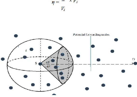
that connects the sender and destination nodes. 2D-RGRP protocol was tested under two scenarios: 2D-RGRP implemented on WSN deployed in 2D terrain and 2D-RGRP implemented and deployed in 3D terrain. Fig. 5.8 depicts the forwarding mechanism in 3D-RGRP. This 3D region based geographical protocol was designed to be implemented in a WSN that is deployed in 3D terrain. The sender in this protocol forwards a packet toward the destination node through a conical forwarding region apex angle of 45 degrees. This apex angle is formed around an imaginary line that connects the sender and destination nodes.
Figure 5:2D-RGRP forwarding mechanism.
3D-RGRP protocol tested under one scenario where a WSN is deployed in 3D space.
The performance of 2D-RGRP and 3D-RGRP were tested with the same network density and the transmission range of sensor nodes was set to 100 meters. The number of nodes that must be deployed in any sender’s transmission range in 2D terrain is specified by Where ηc is the number of nodes in any circular transmission range of any sender node, Ac is the sender’s transmission range area and A is the entire area of 2D deployment terrain.
The number of nodes that must be deployed in any sender’s transmission range of in 3D terrain is given by
Based on (2Ddensity) and (3Ddensity) the number of neighboring nodes of a sender Node and the corresponding the number of nodes in the terrain are given in simulation Table 1. The size of 2D terrain is 500 × 500 m2 and the size of 3D terrain is 500 × 500 × 200 m3. The objective of this experiment is to analyze the effect of nodes’ location errors in implementation of three test cases.
V. Conclusion
The dissertation also provides detailed study of tuning parameters that can be set to make the protocol fit with time sensitive applications. These experiments support the necessity of considering the three dimensional coordinates for accurate routing calculation. The results show that ignoring third coordinate in routing calculation has significant impact on the network performance. Three test scenario of region based routing protocols, which are 2D-RGRP implemented in 2D-WSN, 2D-RGRP implemented in 3D- WSN, and 3D-RGRP implemented in 3D-WSN, are designed and their results compared with each other to verify the effect of location errors on the network performance.
The current versions of 3DRTGP do not consider the mobility of sensor nodes in WSNs. However, a majority of mobile systems employ GPS devices, which can provide the location information of sensor nodes in real- time and the location of destination node can be pre-programmed in all sensors before the network is deployed in the targeted terrain. High overhead, In efficient transmission, decreased time delay, extending the network life time in future work.
REFERENCES
[1] J. Al-Karaki and A. Kamal, “Routing techniques in wireless sensor net- works: a survey,” IEEE Trans. Wireless Communications, vol. 11, no. 6, pp. 6–28, Dec 2004.
[2] J. J. Robles, “Indoor localization based on wireless sensor networks,” AEU- International Journal of Electronics and Communications, vol. 68, no. 7, pp. 578 – 580, 2014.
[3] M. K. Mwila, K. Djouani, and A. Kurien, “Approach to sensor node cal- ibration for efficient localisation in wireless sensor networks in realistic scenarios,” Elsevier Procedia Computer Science, vol. 32, no. 0, pp. 166 – 173, 2014.
[4] H. de Oliveira, A. Boukerche, E. Freire Nakamura, and A. Loureiro, “An ef- ficient directed localization recursion protocol for wireless sensor networks,” IEEE Trans. Computers, vol. 58, no. 5, pp. 677–691, May 2009.
[5] G. Tuna, T. V. Mumcu, K. Gulez, V. C. Gungor, and H. Erturk, “Un- manned aerial vehicle-aided wireless sensor network deployment system for post-disaster monitoring.” Springer, pp. 298–305.
[6] M. Radi, B. Dezfouli, K. A. Bakar, and M. Lee, “Multipath routing in wireless sensor networks: Survey and research challenges,” Sensors, vol. 12, no. 1, pp. 650–685, 2012.
[7] S. Durocher, D. G. Kirkpatrick, and L. Narayanan, “On routing with guar- anteed delivery in three-dimensional ad hoc wireless networks,” Elsevier Wireless Networks, pp. 227–235, 2010.
[8] D. Cook and S. Das, Smart Environments: Technology, Protocols and Ap- plications (Wiley Series on Parallel and Distributed Computing). Wiley- Interscience, 2004.
[9] R. Kieckhafer, “Hard real-time wireless communication in the northern pierre auger observatory,” in Proc. of the 17th IEEE-NPSS Real Time Con- ference (RT), May 2010, pp. 1–8.
[10] Y. Zhang, X. Li, S. Zhang, and Y. Zhen, “Wireless sensoretwork in smart grid: Applications and issue,” in Proc. of World Congress on Information and Communication Technologies (WICT), Oct 2012, pp. 1204–1208.