Spatial Based Planning Direction: Case Study Slum Areas In
Lut Tawar Sub-District, Central Aceh Regency
1Rezza Mien Nugraha, 2Sirojuzilam, and 3Agus Purwoko
1Department of Regional and Rural Development Planning,
University of Sumatera Utara, North Sumatra, Indonesia
2Department of Regional and Rural Development Planning
University of Sumatera Utara, North Sumatra, Indonesia
3Department of Forestry, Faculty of Agriculture
University of Sumatera Utara, North Sumatra, Indonesia
Abstract
The aim of this study is to analyze slum areas in lut tawar sub-district, central aceh regency. According to Decree of
Aceh Tengah Regent Number
188.55/775/DCKP of 2014, five villages in Lut Tawar sub-district are categorized as slum treatment areas. They are Asir-Asir Asia, Bale Atu, Kenawat, Takengon Barat, and Takengon Timur. By using slum analysis method by Ministry of Public Works, there are seven types of data that need to be collected. Datas are collected by surveying related organizations using questionnaire. Slum level is determined by accumulating overall scores analyzed from seven indicators through inventorying phases and data analyzing. The result is that Asir-Asir Asia, Bale Atu, Takengon
Barat, and Takengon Timur are
categorized as low level slum areas. Kenawat is categorized as medium slum area.
Keywords: Slum; Settlement;
Environment; Ministry of Public Works and Housing; Indicators.
Introduction
Slum areas are a problem faced by almost all cities in Indonesia. Slum areas based on
Law Number 1 of 2011 are areas that are not habitable due to irregular buildings, high levels of building density, and the quality of buildings and facilities and infrastructure that do not meet the requirements for habitation. Slums are a challenge for the government. Settlements that are less integrated, less directed and planned, and less attention to the
completeness of facilities and
infrastructure will tend to experience environmental quality degradation, thus creating slums. Regent of Central Aceh in accordance with Regent Decree of Central Aceh Number 188.55 / 775 / DCKP 2014 stipulates five villages located in Lut Tawar Subdistrict as slums that need to be addressed, the area are Asir-Asir Asia, Bale Atu, Kenawat, Takengon Barat, and Takengon Timur.
In 2016 the Minister For Public Works and
Human Settlements (PUPR) issued
roads, environmental drainage, clean water supply, waste management, wastewater management, and fire hazard protection. Slum settlement must be recognized that its existence in the development of the urban area cannot be avoided, therefore in order to minimize the slums that have already emerged, comprehensive efforts are needed to prevent and reduce slums.
Objective of the study
1. The objective of this study is to plan slums alleviatiation in Lut Tawar sub-district by carrying out activities, as follows:
2. Determine the classification of slums in the planning area in Lut Tawar sub-district.
3. Make spatial slum zoning.
4. Make spatial-based planning to
alleviate slums in Lut Tawar sub-district..
Research Methodology
The research location is in Lut Tawar
sub-district, Central Aceh Regency. In
accordance with the Central Aceh Head of Regency Decree Number 188.55 / 775 / DCKP in 2014, there were five villages that became slums handling areas in Lut Tawar sub-district. The five villages are
Asir - Asir Asia, Bale Atu, Kenawat, Takengon Barat, and Takengon Timur.
The planning process in this study have four stages, data inventory, analysis, synthesis and planning. Data inventory phase is collecting data of 7 (seven) slum indicators using questionnaires along with
secondary data taken from related
agencies. The slum criteria analysis stage is the calculation of the percentage of slums from 7 (seven) indicators that have been collected from each village. Each criterion has an assessment in reviewing the slums in an area in accordance with the regulations stipulated in the Regulation of the Minister of Public Works and Public Housing Number 2 of 2016 concerning Quality Improvement of Slum Housing and Slum Settlement.
The synthesis phase is the process of accumulating the value of data analysis of
7 (seven) slum indicators. The
accumulation of all the criteria values is then classified again to determine the level of slums in the village. The following is a classification of slums according to the Regulation of the Minister of Public Works and Public Housing Number 2 of 2016 (Table 1).
Table 1. Classification of Slums
Slum Value Slum Level
<19 No Slum
19-44 Low
45-70 Medium
71-95 High
Source: PUPR Minister Regulation No. 2 of 2016
After determining the level of slums in each region, then zoning is determined in each region as a direction for planning. The zoning is divided into zoning models A, B and C.
where there are only 1 (one) to 3 (three) indicators of slums in the area.
The results of the synthesis phase are then continued by making planning directions in each village according to the level of slums. In accordance with the directives made by the Directorate General of Human Settlements regarding the handling of slum areas, there are two concepts of treatment carried out in accordance with the level of slums. Slightly slums are included in the restoration category, while moderately and extremely slums fall into the category of renewal category.
Result and Discussion
In accordance with the slum analysis method established by the Ministry of Public Works, there are seven types of data that have been collected and analyzed.
Building
Indicators for buildings are assessed from aspects of buildings that are organized, density, and quality of buildings. The
conditions identified to assess the
orginized building are access to the building to the road, the front position of the residential building facing the road, in front of the building facing the river and not above the river, the buildings are not above the river, lake or sea border, and not in the waste area or area high voltage. Based on the assessment of these conditions, the area that has the highest percentage of buildings that are not orginized is Asir-Asir Asia Village at 56.44% with 202 units of buildings.
The conditions identified for assessment are building density. the density of buildings is considered unsuitable if the number of houses (settlements) does not leave 25% of the land area or the total area
of the entire area. Based on the assessment of these conditions, Bale Atu has the highest percentage of 77.85% where the settlement area is 10.9 Ha and the village area is 14 Ha.
The conditions identified for the
assessment of building quality are land area, number of occupants, condition of the roof, walls, and type of floor in the building. Based on the assessment of these conditions, the highest quality of buildings that do not meet the requirements are in Takengon Barat village with a percentage of 64.25%.
Environmental Roads
Indicators for environmental roads are assessed by environmental road services and road quality. Environmental road service is the area that is served by the existing environmental road and the area of the village area. Based on this assessment, Kenawat is the largest area of percentage that has not been served by environmental roads by 94.98% of the total area with a total length of existing roads of 6592 meters..
Value of road quality by calculating the length of existing roads and damaged roads in the area. Based on this assessment, Takengon Barat is the area that has the largest percentage of road damage, which is 69.75% of the total length of the existing road in the area.
Water Supply
water sources. Based on this assessment, the most inadequate distribution of clean water is in Bale Atu village, with a percentage of 47.69%.
The indicator used to find out the water needs in an area is to identify the amount of clean water that is obtained by the community compared to the amount of water obtained by each household every day. According to Law No. 7/2004 concerning water resources, the amount of water needed by households is 60 liters/day. Based on these assessments, the percentage of the area that was least fulfilled by clean water was found in Asir-Asir Asia at 91.59% of the 202 number of household heads in the village.
Wastewater
Indicators for wastewater are assessed from the wastewater management system and wastewater management facilities and infrastructure. Kenawat has the highest percentage of waste water management systems that are not suitable for 54.58%.
The condition of facilities and
infrastructure that have the highest percentage of non-conformity are also in Kenawat, which is 55.64%.
Enviromental Drainage
Environmental drainage conditions in the slum area are assessed by the inability to drain water runoff, drainage service coverage, connected to the urban drainage system and drainage quality. The condition that is considered to identify the inability to drain runoff is the occurrence of inundation for more than 30 (thirty) minutes. Based on this identification, Takengon Barat has the highest percentage of the inundation area, which is 28% of the area.
The conditions considered related to drainage service coverage are the area and the length of existing drainage available in
slums. Based on the results of
identification, Kenawat has the highest percentage of areas that have not been served by drainage, which is 94.98% of the area with an existing drainage length of 6592 meters.
Not connected to the urban drainage system causes water to not flow and cause inundation. From the results of field identification it is known that the drainage that already exists in all the slums in the Lawar Subdistrict are all connected to the upper channel
The identified conditions related to the maintenance of drainage and the quality of construction are the length of the existing drainage and the poor drainage conditions. Based on the results of identification, Takengon Timur is an area that has the largest percentage of damage and not maintained drainage, which is 56.5% of the existing length 6971 meters.
Waste Management
service. After being identified, Kenawat is an area that does not have a TPS or TPA.
The indicator to assess the waste management system that is technically appropriate is the availability of household waste disposal and transportation of waste from the house to the TPS / TPA. The indicator is examined in each of the household in the area. Based on this assessment, Kenawat has the highest percentage of waste management systems that are not technically appropriate at 91.55%.
Fire Hazard Protection
Fire protection indicators in an area are fire protection facilities and infrastructure in the area, such as water hydrants, fire
extinguisher, or water pumps that provide initial handling in the area before firefighters arrive to reduce the impact of fires. Based on observations in the field, all slums in Lut Tawar Subdistrict have no fire protection facilities and infrastructure.
Slum Classification
The next stage is the determination of slum values in the research area. This slum value is obtained through the accumulation of all values that have been analyzed from 7 (seven) indicators through the stages of data inventory and analysis. The following are the results of the accumulation of all indicators of slums from the data that have been analyzed (Table 2).
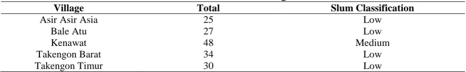
Table 2. Slum Value of Regions
Village Total Slum Classification
Asir Asir Asia 25 Low
Bale Atu 27 Low
Kenawat 48 Medium
Takengon Barat 34 Low
Takengon Timur 30 Low
The results of the slum area assessment, Kenawat get the highest slum value compared to the other four villages, 48 and fall into the category of Medium Slum. The coverage of road services and drainage then garbage and fire protection become the focus of attention, because it provides the highest slum value in the village.
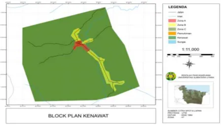
Slum Levels Zoning
After identifying indicators of slums and their values in each village, then zoning was carried out in each village with the overlay method to get the block plan. This block plan aims to classify zoning into
Zone A, Zone B, and Zone C to determine the slum zone that needs prevention and improvement.
Table 3. Zoning
Village Zone A Zone B Zone C
Asir-Asir Asia Buildings, Roads, Drinking Water, Drainage, Waste Management, and Fire Protection
Building, Road, Drinking Water, Drainage, Fire Protection
Road, Drainage, Fire Protection
Bale Atu - Buildings, Roads,
Drinking Water, Fire Protection
Building, Waste Management, Fire Protection
Kenawat Buildings, Roads,
Drinking Water, Drainage, Waste Management,
Wastewater and Fire Protection
Building, Road, Drainage, Wastewater and Fire Protection
Roads, Drainage and Fire Protection
Kampung Zona A Zona B Zona C
Takengon Barat Buildings, Roads, Drinking Water, Drainage, Waste Management, and Fire Protection
Building, Road, Drainage and Fire Protection
Building and Fire Protection
Takengon Timur Buildings, Roads, Drinking Water, Drainage, Waste Management, and Fire Protection
Building, Road, Drainage and Fire Protection
Building and Fire Protection
5. Arahan Rencana Pengentasan Kawasan Kumuh
dan hydran. Kenawat yang termasuk dalam kategori kumuh sedang, maka konsep penanganan yang dilakukan adalah peremajaan dimana kegiatan yang dilakukan lebih intensif seperti rekonstruksi dan penataan ulang, penambahan fasiitas infrastruktur penunjang kawasan seperti jalan, drainase, dan hydran.
Figure 1. Zoning Kenawat Village
Conclusions
Based on the results of the research and
analysis and discussion, the following
conclusions are drawn:
1. The level of slums of Lut Tawar Subdistrict in accordance with the Regulation of the Minister of Public Works and Public Housing Number 2 of 2016 is in the category of low level slums located in Asir-Asir Asia, Bale Atu, Takengon Barat, Takengon Timur and slums being in Kenawat village.
2. Based on the results of the overlay of the seven slum indicators, there are three zones that serve as reference for planning, that is Zone A, Zone B, and Zone C.
3. In accordance with the assessment of slums in each village, there were two ways of handling each village according to the level of slums in the area. Asir-Asir Asia, Bale Atu, Takengon Barat, and Takengon Timur are included in the category of low level slums, the concept of handling them is restoration, while Kenawat which is in the category of medium level slum, then the concept of handling is renewal.
Suggestions
1. The Central Aceh District Government is expected to be able to reduce the level of slums in Lut Tawar District by improving physical conditions and managing the construction of buildings in slum areas. 2. The Central Aceh District Government
needs to immediately prepare a master plan
for the handling of slum areas
comprehensively by involving relevant agencies.
Reference
[1] Miranti Jani, R. dan Rutiana, D. 2007.
Strategi Perencanaan Pembangunan
Permukiman Kumuh Kasus Pemukiman Bantaran Sungai Bengawan Solo, Kelurahan
Pucangsawit, Surakarta. Gema Teknik.
Volume 1. Surakarta (ID)
[2] Penanganan Kawasan Permukiman
Kumuh. Direktorat Jenderal Cipta Karya.
Kementerian Pekerjaan Umum dan
Perumahan Rakyat. Volume 1. 2015. Konsep Penanganan Permukiman Kumuh.
[3] Peraturan Menteri. PUPR.
NO.2/PRT/M/2016. Peningkatan Kualitas
Terhadap Perumahan Kumuh dan
Permukiman Kumuh
[4] Petunjuk Teknis. Direktorat Jenderal Cipta Karya. Kementerian Pekerjaan Umum dan Perumahan Rakyat. 2015. Penyusunan Data Baseline dan Perhitungan Capaian Kegiatan Peningkatan Kualitas Permukiman Kumuh Perkotaan.
[5] Petunjuk Teknis. Direktorat Jenderal Cipta Karya. Kementerian Pekerjaan Umum dan Perumahan Rakyat. 2017. Petunjuk Teknis Tempat Pengolahan Sampah 3R.
[6] Rizka, H. 2018. Perencanaan Penanganan Kawasan Permukiman Kumuh Di Kelurahan Tanjung Tiram Kecamatan Tanjung Tiram Kabupaten Batu Bara. [Tesis]. Medan (ID): Universitas Sumatera Utara
[7] Rieneke, L. 2016. Perencanaan
Pencegahan dan Peningkatan Kualitas
Permukiman Kumuh Perkotaan dengan