A DEVELOPMENT OF WEB-BASED BERNESE AUTOMATED GLOBAL POSITIONING SYSTEM PROCESSING PACKAGE
HARIS SURYAMEN BIN SUHASRIL
A thesis submitted in fulfilment of the requirement for the award of the degree of Master of Science (Geomatic Engineering)
Faculty of Geoinformation Science and Engineering Universiti Teknologi Malaysia
BAHAGIAN A – Pengesahan Kerjasama*
Adalah disahkan bahawa projek penyelidikan tesis ini telah dilaksanakan melalui kerjasama antara _____________________dengan______________________ Disahkan oleh :
Tandatangan : Tarikh :
Nama : Jawatan : (Cop rasmi)
* Jika penyediaan tesis/projek melibatkan kerjasama.
BAHAGIAN B – Untuk Kegunaan Pejabat Sekolah Pengajian Siswazah Fakulti Kejuruteraan dan Sains Geoinformasi
Tesis ini telah diperiksa dan diakui oleh:
Nama dan Alamat Pemeriksa Luar : DR. SOBAR SUTISNA
National Agency for Surveys & Mapping BAKOSURTANAL
Jalan Raya Bogor km.46
Cibinong
Indonesia
Nama dan Alamat Pemeriksa Dalam : PROF. DR. HALIM BIN SETAN
Fakulti Kejuruteraan san Sains Geoinformasi Universiti Teknologi Malaysia
81310 UTM Skudai
Johor Darul Ta’zim
Disahkan oleh Timbalan Dekan (Penyelidikan & Pengawasan Siswazah) Fakulti Kejuruteraan san Sains Geoinformasi:
Tandatangan : Tarikh :
Nama :
ABSTRACT
ABSTRAK
Bernese Processing Engine (BPE) di dalam bentuk skrip boleh digunakan untuk menjalankan program Bernese dalam bentuk automatik, dan pada masa yang sama ia boleh diakses pada bila-bila masa melalui internet. Dengan menggunakan internet, lebih daripada satu komputer boleh digunakan untuk menjalankan program Bernese dan pada masa yang sama program itu boleh dipakai secara berterusan dengan menggunakan komputer yang sama. Dengan itu satu skrip khas diperlukan untuk mengawal penggunaan program Bernese, mod automatik daripada program, bersaling tindak dengan web server, hubungan dengan internet, dan interaksi dengan pengguna internet pada masa yang sama; khasnya bagi penggunaan sistem operasi Windows. Metodologi yang digunakan adalah dengan merekabentuk dan membangunkan skrip automatik pada aplikasi laman-web peribadi. Server dibina dengan menukarkan komputer peribadi yang menggunakan Internet Information Service (IIS). Untuk server dibangunkan dan disimulasikan dengan menggunakan teknologi Common Gateway Interface (CGI) dan Hyper Text Markup Language
TABLE OF CONTENTS
CHAPTER TITLE PAGE
THESIS STATUS DECLARATION
SUPERVISOR’S DECLARATION
DECLARATION ON COOPERATION WITH OUTSIDE AGENCIES AND CERTIFICATION OF
EXAMINATION
FRONT PAGE... i
DECLARE ... ii
TITLE COVER ... iii
DECLARE ... iv
DEDICATION... v
ACKNOWLEDGEMENTS... vi
ABSTRACT ... vii
ABSTRAK ... viii
CONTENT ... ix
FIGURES ... x
ABBREVIATION ... xi
APPENDIX ... xii
1 INTRODUCTION... 1
1.1 Introduction ... 1
1.2 Problem Statement ... 1
1.3 Research Objectives ... 2
1.4 Research Scope ... 2
1.6 Research Methodology ... 3
1.7 Thesis Outline ... 5
2 LITERATURE REVIEW ON GPS PROCESS AND THEORY ... 8
2.1 Bernese Software Version 4.2... 8
2.1.1 Orbit Computation ... 9
2.1.2 Data Conversion... 10
2.1.3 Processing Modules ... 10
2.1.3.1 Code Single Point Positioning (CODSPP)... 11
2.1.3.2 Forming Single Difference Base (SNGDIF) ... 12
2.1.3.3 Phase Data Screening (MAUPRP)... 12
2.1.4 Processing Strategies... 13
2.1.5 Estimation ... 14
2.2 The GPS Observables ... 15
2.2.1 Pseudorange ... 16
2.2.2 Pseudorange Observation Equation ... 16
2.2.3 Phase Pseudorange Observation Equation ... 17
2.3 GPS Differencing Techniques... 18
2.4 Linear Phase Combination ... 21
3 GPS HIGH PRECISION PROCESSING PROCEDURE USING BERNESE……….. 23
3.1 Development of Web-Based GPS Automation... 22
3.2 Hardware and Software Set – Up... 26
3.3 Data Preparation... 27
3.4 Transfer Part... 2
3.5 Orbit Part... 29
3.6 Clock Correction ... 33
3.7 Single Differences... 36
3.9 Adjustment Parameter... 38
3.9.1 Preliminary Estimation ... 38
3.9.2 Residual Screening... 40
3.9.3 Final Estimation ... 40
3.9.3.1 Residual Elimination... 41
3.9.3.2 Residual Phase 2 ... 41
3.9.3.3 Residual Phase 3 ... 41
3.9.3.4 Residual Phase 4 ... 42
3.10 Final Result ... 44
3.10.1 Troposphere Estimation ... 44
3.10.2 Ionosphere Modeling ... 44
3.10.3 Ambiguity Resolution ... 45
4 AUTOMATION SCRIPT... 47
4.1 Sequence of the Programs... 47
4.2 Bernese Processing Engine ... 50
4.3 Automation Script ... 55
5 WEBSITE AND ONLINE SERVER – USER ... 60
5.1 Introduction ... 60
5.1.1 Hyper Text Transfer Protocol ... 60
5.1.2 Common Gateway Interface ... 61
5.1.3 Other Techniques ... 62
5.2 Interaction of Server – User ... 63
5.2.1 Sending Request... 63
5.2.2 Server Response ... 64
5.3 Operation Behind Server... 65
5.3.1 Server – Side Programming ... 66
5.3.2 Authentication ... 67
5.3.3 Server – Side HTML Extensions ... 67
5.4 User Online – Request ... 68
5.4.1 Getting Document Online ... 78
5.4.2 Checking Document... 70
5.5.1 Server Response ... 71
5.5.2 Submitting Forms... 72
5.5.3 Submitting Data ... 72
5.6 Extensional Browsing ... 73
5.7 Virtual Server ... 74
6 WEB – BASE AUTOMATION……….. 76
6.1 Conceptual Design ... 76
6.2 User Interface ... 77
6.3 Implementation of On-Line Web – Based Bernese Automated Processing... 79
6.4 Server Set-up... 80
6.5 Bernese Installation... 81
6.6 Bernese Compilation & Linking ... 81
6.7 Processing Test ... 82
6.8 Performances……… 84
7 CONCLUSION AND RECOMMENDATION ... 87
7.1 Conclusion ... 87
7.2 Recommendation ... 88
REFERENCES……… 90
Appendix 1……… 94
CHAPTER 1
INTRODUCTION
1.1 Introduction
An automated system becomes an important key to ease the processing and analysis of data collected by a network of Global Positioning System (GPS) stations. Malaysia, which has 12 GPS active stations that located throughout the country, requires the time consuming data processing tasks to be performed automatically. (Satirapod et al., 2000)
1.2 Problem Statement
As more than one computer can be used to run a program and also as the programs can be run online through internet or Local Area Network (LAN) cable or Wireless LAN (WLAN), a system of GPS data processing using Bernese software which runs automatically and allow online users to access the program simultaneously must be considered.
2 2. Creation of web’s interface and the operation of web server where the
program would be placed. A single script is needed to control all over the Bernese program.
3. Automated mode of program in the web server, link with the internet, and interaction with the online users.
1.3. Research Objectives
The objectives of this study are as the following:
1. To carry out interactive GPS processing system using Bernese software package.
2. To develop Processing Control Script (PCS) for automation of the GPS processing system.
3. To develop and implement the web-based GPS automated processing system.
1.4. Research Scopes
3 1.5 Contribution of Research
The benefit for development of the GPS automated system hopefully will contribute to the dissemination of automated GPS solutions for the GPS users in the country.
This research is useful in supporting the existing MASS (Malaysia Active Satellite System) stations, developed by Geodetic Data Processing Center (GDPC) of Department of Survey and Mapping (Jupem, 2005) or other International GPS service (IGS) station.
The Web-based GPS processing system will be useful to the online users in the country to submit their GPS data files via internet for automatic processing (result will be notified via the email).
1.6 Research Methodology
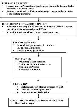
Figure 1.1 shows the flowchart of methodology for this research. In order to achieve the objectives which is explained further by seven outlines of this thesis.
4
LITERATURE REVIEW
y Journal papers, Proceedings, Conferences, Standards, Patent, Books/
Handbooks, Internet Search.
y Summarize method, problem, methodology, concept and conclusion
of the existing literature.
DEVELOPMENT OF VARIOUS CONCEPTS
y Identification of program to be used and analyzed (Bernese, System
operation, Automation script, and Web).
y Identification of main ideas and developing concepts.
BERNESE PROGRAM
y Manual processing using Bernese and
Interactive Simulations
y Understanding parameters
AUTOMATION
y Operating System selection
y Making of the Automation script
y Modeling of Process
y Computer Simulation
WEB DESIGN
• Determination of placing program on Web
• Selection of Web applications
• Improvement of Web design
FINALIZING OF AUTOMATED SYSTEM ON WEB
y Thesis writing report
Figure 1.1 General Flowchart of Research Methodology
By using Journal papers, proceedings, conferences, books, handbooks, and Internet search, we can summarize appropriate methods for methodology, concepts, and creating the script for GPS Automation Processing System.
5 The media for creating the Automation Script and the Web is a Personal Computer at FKSG laboratory, which was set-up for the purpose of providing the preliminary server for this project.
The Server for this research is built by transforming a Personal Computer using Internet Information Service (IIS) and active Practical Extraction and Reporting Language (active PERL). The Web for the server is developed and simulated by using many types of the hypertext technologies such as Common Gateway Interface (CGI), Page Hypertext Preprocessors (PHP), Active Server Page (ASP) and Hyper Text Markup Language (HTML) by the Microsoft Frontpage.
1.7. Thesis Outline
Thesis consists 7 chapters. Chapter 1 presents discussion on the topic being studied such as issues and problems, research objectives, scope of study, significance of study, and research methodology.
The related theory used is being discussed in Chapter 2. The discussion is focused on definition, concept about GPS measurement, Bernese short-review, the processing of data in Bernese software, and Automation Script.
Chapter 3 discusses largely on the basic operation of the Bernese version 4.2, the Orbit computation, Data Programming and the final Estimation strategies according to the type of GPS observation.
Chapter 4 deals with the development of the automation process by using the Bernese software, testing a simple input-data from the RAW data for particular baseline and processing a Single Point Positioning automatically.
REFERENCES
Alves Costa, S. M., Fonseca Junior, E.S., Fazan, J.A. (2001). Preliminary Results of SIRGAS 2000 Campaign – IBGE Analysis Center. Proceedings International Geomatic Symposium, Rio de Janerio, RJ, Brazil.
Barnes, J. B., Ackroyd, N., and Cross, P. A. (1998). Stochastic Modelling for Very High Precision Real-Time Kinematic GPS in an Engineering Environment. Proceedings of FIG XXI International Conference, 21-25 July, Brighton, UK, Commision 6, 61-76.
Becker, M., Caporali,A., Figurski, M, Grenerczy, G., Kenyeres, A., Hefty, J.,Marjanovic, M., Stangl, G. (2001). A Regional ITRF Densification by Blending Permanent and Campaign. Proceedings International Association of Geodesy 2001 Scientific Assembly, Budapest, Hungary.
Beutler, G. Rothacher, M.; Springer (1989). The international GPS service (IGS): An interdisciplinary service in support of earth sciences, Advances in Space Research, 23(4), 631-653.
Blewitt, G., M. B. Heflin, K. J. Hurst, D. C. Jefferson, F. H. Webb, and J. F. Zumberge, (1995) Absolute far-field displacements from the 28 June 1992 Landers earthquake sequence, Nature, 361, 340-342.
Brown, N., Williamson, I., Kealy, A. (2002). Stochastic Modelling of GPS Phase Observations. The University of Melbourne, Australia.
Forde, Peter. (1994). A Scientific Scrutiny of OT3. UK. CHESHIRE UK SK14 3HX, 54 Underwood Court, Hyde.
91 Hugentobler, U., Schaer, S., Fridez, P. (2001). Bernese GPS Software Version 4.2.
Manual. Astronomical University of Berne, Switzerland.
Hofmann-Wellenhof, B. and others. (1994) GPS Theory and Practice. 2nd Edition. Wien: Springer-Verlag,.
IGS, Jet Porpulsion Laboratory (1998). Official Website at http://igscb.jpl.nasa.gov/ Jupem (2001). Official Website at http://jupem.gov.my
Keenan, C.R. and Cross, P.A. (2001). Stochastic Modelling: The Crucial Element in High-Fidelity DGPS Quality Assessment?. Proceedings of Hydro’2001, Conference of The Hydrographic Society, University of East Anglia in Norwich, 26-30 March 2001, 12 pp.
Leick, A. (1995). GPS Satellite Surveying (2nd edition). John Wiley, New York. Li, X., Cheng, P. (2001). Data Processing of APRGP2000. PCGIAP WGI Workshop,
Penang, Malaysia.
Mao, A., Harrison, C. G. A., Dixon, T. H. (1999). Noise in GPS coordinate time series. Journal of Geophysical Research, Vol. 104, No. B2, Pg 2797-2816, February 10, 1999.
Mervart, L., Douša, J. (2001), On Hourly Orbit Determination, presented at IGS Network Workshop, Oslo, Norway, July 12-15 2000.
Muellerschoen, R.J., Bertiger, W.I., Lough, M., Stowers, D., & Dong, D. (2000). Proc. National Meeting U.S. Institute Of Navigation, Anaheim, California, 26-28 January.
Rothacher and Mervart, (1992) Bernese GPS Software Version 4.0, Printing Office University of Berne.
Rizos, C., (1999). The Singapore multiple GPS reference station network: some preliminary test results, Presented at GPS/GIS Showcase, Nanyang Technological University, Singapore, 19-20 November.
92 Rizos, C., Satirapod, C., Chen, H.Y., & Han, S. (1999). GPS with multiple reference
stations: surveying scenarios in metropolitan areas, 6th South East Asian Surveyors Congress, Fremantle, Australia, 1-6 November, 37-49.
Rozsa, S., Mayer, M., Heck, B. (2002). On the GPS Measurements in the EUCOR-URGENT Network. ENTEC Spring Workshop Vienna 2002, institute fur Geologie der Universitat Wien, Italy.
Satirapod, C., Wong.K.., Rizos.C. (2000). A Web-based Automated GPS Processing System, 2nd Trans Tasman Surveyors Conference, New Zealand 20 –26 August 2000
Schaer, C., Beutler, E. Brockmann, U. Wild, A. (1999), Annual Report 1996 of the CODE Analysis Center of the IGS, in IGS Annual Report for 1996, edited by J.F. Zumberge et al., Central Bureau, JPL, Pasadena, Ca.
Scott, Michael Lee. Programming Language Pragmatics. San Francisco: Morgan Kaufmann, 2000.
Silberschatz, Abraham. Applied Operating System Concepts. New York: John Wiley, 2000.
Soler, T., Mao, A., Harrison, C. G. A., Dixon, T. H. (1999). Noise in GPS coordinate time series. Journal of Geophysical Research, Vol. 104, No. B2, Feb. 10, 1999.
SNAP,(1999).webpage http://www.gmat.unsw.edu.au/snap/work/singapore.htm. Strang, G., & Borre, K. (1997). Linear Algebra, Geodesy, and GPS,
Wellesley-Cambridge Press, Wellesley, Mass., 624pp.
USGS Online Publication, (2001), From: Kious and Tilling, This Dynamic Earth:
The Story of Plate Tectonics.
Wang, J. (1999). Modelling and Quality Control for Precise GPS and GLONASS Satellite Positioning. Proceedings International Association of Geodesy 2001 Scientific Assembly, Budapest, Hungary.
Weinman, Lynda. Creative HTML Design.2. Indianapolis, IN: New Riders Pub; 2001.
93 Williamson, Heather. Dreamweaver in a Nutshell: A Desktop Quick Reference. CA:
OReilly, 2002.
Wolf, W., Hendrix, (2001). Computers as Components: Principles of Embedded Computing System Design. San Francisco, CA: Morgan Kaufmann Publishers.
Zumberge, J.F., (1999). Automated GPS Data Analysis Service, GPS Solutions, Vol. 2, No. 3, 76-78.