University of East London Institutional Repository: http://roar.uel.ac.uk
This paper is made available online in accordance with publisher policies. Please scroll down to view the document itself. Please refer to the repository record for this item and our policy information available from the repository home page for further information.
Author(s):
Ekpenyong, Frank; Brimicombe, Allan; Palmer-Brown, Dominic.
Article title:
Updating Road Network Databases: Road Segment Grouping Using Snap-Drift Neural Network.Year of publication:
2007
Updating Road Network Databases: Road Segment
Grouping Using Snap-Drift Neural Network
Frank Ekpenyong1, Allan Brimicombe1, Dominic Palmer-Brown2,
1
Centre for Geo-Information Studies, University of East London, 4-6 University Way, London E16 2RD; Tel: +44(0)2082232352, Fax: +44(0)2082232918
Email: [email protected]
2
School of Computing and Technology (SCoT), University of East London, 4-6 University Way, London E16 2RD; Tel: +44(0)2082232170, Fax: +44(0)2082232963
Email: [email protected]
KEYWORDS: Road Network Update, Local Context Information, Snap-Drift Neural Network, Road Segment Grouping
1. Introduction
At present a number of methods are being used to update road network databases including ground survey, driving along roads with GPS and analysing satellite images to register changes. Previous research has aimed at addressing three update functions: road extraction, change detection and change representation (Zhang, 2004). Different types of image processing algorithms have been developed for each purpose. While image-based road updating approaches have had success, their accuracy is directly tied to the quality of the data (Klang, 1998) and object model used for road extractions (Gerke et al., 2004).
An alternative approach being investigated here is where service users of in-vehicle navigation systems might passively collect characteristics of any “unknown road” (roads not in the database) on behalf of the data provider. These data along with similar track data provided by other service users are transferred back to the provider and inputted into an artificial neural net (ANN) which decides whether to automatically insert the “unknown road” into the road network database on probation. At a later stage when there is enough certainty on road geometry and characteristics (cross-checking where necessary with other data sources such as remote sensing) the probationary flag could be lifted and permanently added to the road network database. The ANN would rely on road and neighbourhood attributes to predict whether any “unknown road” is actually a road that needs to be added to the central database as opposed to long driveways, car parks or off-road tracks which would generally not.
2. Snap-Drift Neural Network
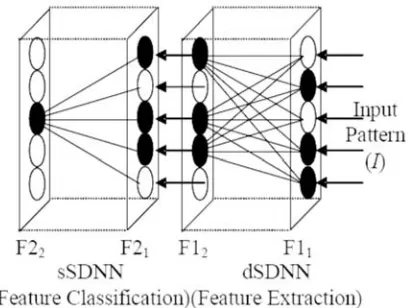
[image:3.612.207.411.213.367.2]Different types of neural networks have been employed in the past for map matching and road extraction purposes. In this study the Snap-Drift neural network (SDNN) developed by Lee and Palmer-Brown, (2004) is deployed. One of the strengths of the SDNN is that in a non-stationary environment where new patterns (e.g. new candidate roads attributes) are introduced over time, the learning process utilises a novel algorithm that performs a combination of fast, convergent, minimalist learning (snap) and more cautious learning (drift) to capture both precise sub-features in the data and more general holistic features. The two learning modes (snap and drift) are combined within a learning system (Figure 1) that can toggle its learning style (Lee et al., 2004).
Figure 1: Snap-Drift Neural Network (SDNN) architecture (from Lee & Palmer-Brown, 2005)
On presentation of input data patterns at the input layer F11, the distributed SDNN
(dSDNN) will learn to group them according to their general features using snap-drift (Lee and Palmer-Brown, 2005). The F21 nodes, whose weight prototypes best match
the current input pattern, receive dSDNN outputs as input data to the selection SDNN (sSDNN) module for the purpose of feature grouping. Unlike back propagation which performs optimization for classification (rather than feature discovery), by pushing features in the direction that minimizes error on the output nodes without any requirement for the feature to be statistically significant within the input data, SDNN toggles learning mode to find a rich set of features in the data and uses them to group the data into categories as illustrated below. Thus the SDNN was used to group road segments into the road types based on the road segment information and local context data supplied to it.
3. Data Description
road segments, 13 local streets segments and 30 minor road segments. Table 1 shows summary of all the available road types and the nature of roads within each class. Local context information such as length of road segment, speed limit, number of address points, number of crossings/exits/side roads, and type of road feature was collected for the buffered area of each road segment.
Figure 2: Scenario one in East London (road data Crown Copyright).
Figure 3: Scenario two near Stansted Airport (road data Crown Copyright).
3.1. Input Representation for SDNN
[image:4.612.108.504.388.598.2]Type of road feature A road B road Local street Minor road
Single carriageway 8 20 13 28
Dual Carriageway 10 0 0 0
Roundabout 0 4 0 0
Slip road 1 0 0 0
Traffic Island 1 6 0 2
Total 20 30 13 30
Table 1: Summary of composition of each road class considered.
3.2. Results
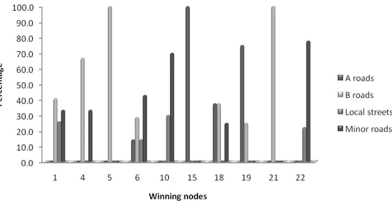
[image:5.612.133.526.329.534.2]Results are presented in Figure 4 and 5 and in Table 2. Figure 4 shows the winning nodes and the road class composition on each node. For instance, winning node 19 is made up of 16 road groupings composed of 75% A roads and 25% B roads (Figure 4). Relying on the concept that the class with highest composition wins, then winning node 19 would be assigned A roads. Using this concept, overall, the SDNN groups about 62% of patterns into their actual classes after 10 epochs and converges after 50 training epochs.
Figure 4: Plot of SDNN output showing the composition of road classes in each winning node
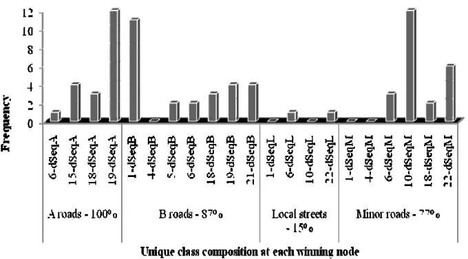
On inspection of the dSDNN (d-node) nodes, most of the winning nodes have unique
d-nodes sequences (dSeq) that in the majority of cases represent unique road classes (Figure 5). In this case winning node 19 is separated, based on its d-node sequence, to 19-dSeqA for A roads and 19-dSeqB for B roads. Only the correctly mapped (unique)
Figure 5: Plot showing distribution of correctly mapped road classes across the winning nodes.
Most of the inaccurate groupings occurred as a confusion between the local streets and minor roads. This is explained by the fact that both road inputs are characterised by few and similar variables as shown in Table 1 and in reality variables like speed limit, address point counts and nature of roads of both local streets and minor roads rarely differ. In addition the small number of inputs available for the training could also affect the local streets class grouping accuracy since only 6 out of 13 available local streets input data were used for training compared to other road classes with between 20 to 30 inputs and half of each class randomly selected for training.
A roads B roads Local streets Minor roads Total Group accuracy
A roads 20 0 0 0 20 100%
B roads 0 26 0 4 30 87%
Local streets 0 0 2 11 13 15%
Minor roads 0 2 5 23 30 77%
Table 2: Grouping accuracy of SDNN results
4. Conclusions and Future Work
The result of the SDNN offers a fast method of learning that preserves feature discovery and is capable of grouping road patterns according to their local context information. However, it is also clear that simply performing unsupervised learning to find the most natural groupings is insufficient to classify all road types accurately. The result represents a positive first step towards updating road network by using a candidate road’s local context information, but later work will involve applying the SDNN for road classification using real user-collected data and much larger road input patterns to see how it performs. The results of this work will be available for presentation at the conference.
Acknowledgements
References
BAUMGARTER, A., ECKSTEIN, W., MAYER, H., HEIPKE, C. & EBNER, H. (1997) Context-Supported Road Extraction. in Automatic Extraction of Man-Made Objects from Aerial and Space Images II, Birkhaeuser Verlag, Basel, pp. 299-308. .
GERKE, M., BUTENUTH, M., HEIPKE, C. & WILLRICH, F. (2004) Graph-supported verification of road databases. ISPRS Journal of Photogrammetry
and Remote Sensing, 58, 152.
KLANG, D. (1998) Automatic detection of changes in road databases using satellite imagery. International Archives of Photogrammetry and Remote Sensing, 32 (Part 4), 293-298.
LEE, S. W. & PALMER-BROWN, D. (2005) Phrase recognition using snap-drift learning algorithm. The Internation Joint Conference on Neural Neural
Networks (IJCNN' 2005). Montreal, Canada, 31st July - 4th August.
LEE, S. W., PALMER-BROWN, D. & ROADKNIGHT, C. M. (2004) Performance-guided neural network for rapidly self-organising active network management.
Neurocomputing, 61, 5.
ZHANG, Q. (2004) A Framework for Road Change Detection and Map Updating.
International Archives of the Photogrammetry, Remote Sensing and Spatial
Information Sciences, Vol. 35, Part B2, pp.720-734.
Biography
Frank Ekpenyong is a PhD researcher in the Centre for Geo-Information Studies, University of East London, He holds an MSc in Geo-information Science from Wageningen University and Research Centre, The Netherlands. His special interests are in change detection, location based services, spatial data analysis, artificial neural network and remote sensing image analysis.