Android Based Citizen Service Mashup System (CSMS)
Ingale Hitesh, Electricwala Faraaz, Shaikh Abdul Sattar, Ansari Mohd Ahmad
*
M.H. Saboo Siddik College of Engineering, Information Technology Department, University Of Mumbai, India
DOI: 10.29322/IJSRP.8.4.2018.p7625
http://dx.doi.org/10.29322/IJSRP.8.4.2018.p7625
Abstract- India is the World’s largest democracy, with 1.25
billion people governing the nation. Problems in organization influencing everyday existence of native will undoubtedly happen. With government help and altruism of other national, these can be comprehended. Thus, government declares lead-plans covering the advantages of individuals who requires little push to advance in life. Online Mashup system permits both the administration staff and citizens of India to impart, propositions arrangements and collaborate over the issues. No such solution exists starting at now, consequently proposed framework will make a powerful organization, cognizant nationals and fruitful government. A Concentrated mashup will ensure that everyone of the issues of the citizens are recorded alongside, it will act as repository to derive a conclusion about the resolvement and it will act as helping hand to the strategy maker. This framework appears in light of the fact that a citizen wants to repost an issue he has to go through the tedious job of submitting the application and the response of organization is moderate because of sheer number of such complaints and their handling. This framework will make all the written application digitized and furthermore take into consideration of quick activities. This solution will make governance Simple, Moral, Accountable, Responsive, Transparent (SMART). Written application at it as least prompting simplicity of responsibility, lessening, perplexity, increase in work rate and effectiveness.
Index Terms- Real time tracking, accident detection, reporting, traffic, safety, anti theft, potholes, security, vehicle accident.
I. INTRODUCTION
he municipal bodies of India are vested with a long list of functions delegated to them by the state governments under the municipal legislation. These functions broadly relate to public health, welfare, regulatory functions, public safety, public safety, public infrastructure works, and development activities. Public health includes water supply, sewage and sanitation, eradication of communicable diseases. Welfare includes public facilities such as education, recreation. Regulatory functions relate d to prescribing and enforcing building regulations, encroachments on public land, birth registrations and death certificate. Public safety includes fire protection, street lighting. Public works measures such as construction and maintenance of inner city roads. In addition to the legally assigned functions, the sectorial departments of the state government often assign unilaterally, and on an agency basis, various functions such as family planning, nutrition and slum improvement, disease and epidemic control. The CSMS framework permits client
confronting a similar issue to report it again and subsequently expanding its eamestness each time another client reports a similar issue. This implies numerous clients are confronting similar issue, henceforth it should take the priority for arrangement execution of same. Likewise, the characteristics of the issue are captured by the CSMS framework instead of depending on the human side of the judgement. The traditional framework does not permit the citizen who has reported the issue to monitor the issue resolvement process and hence organization can hang that issue in between and declare it as completed. The CSMS framework has the feature that enables organization to transfer photo of whatever work is done during the Service Level Agreement (SLA). Citizen uploaded photos will be opened subsequently to whoever has reported a similar issue and will be able to see the improvement in repair work.
II. LITERATURESURVEY 1. Vijaya Bhaskar, Gowri Manohar (2016)
“Surface pothole depth estimation using stereo mode of imageprocessing”
International Journal of Advanced Research in Engineering and Technology
In this Research paper author Vijaya Bhaskar and Gowri Manohar explain the estimate the depth of the pothole and other attributes by the use of stereopsis algorithm. Author’s approach is aimed at pothole depth estimation in stereo mode of image processing via un-caliberated mode of rectification. Reasonably accurate calculations of pothole mean depth value have been estimated using the algorithm. Thus future work can be carried out using caliberated rectification methodology for depth estimation to improve accuracy. Also, a mobile navigation system can be designated to interface with the vision system in dynamic environment.
2. Youngtae Seungki Ryu(2015)
“Pothole Detection System using a Black-box Camera” Multidisciplinary Digital Publishing Institute
In this Paper author Youngtae & Seungh Ryu explains a new pothole detection system using a commercial black-box camera. The proposed system detects potholes over a wide area and at low cost. We have developed a novel pothole-detection algorithm specifically designed to work with the embedded computing environments of black-box cameras. Experimental results are presented with our proposed system, showing that potholes can be detected accurately in real-time. The proposed pothole-detection algorithm was designed and implemented in consideration of the limited computing power of the embedded
systems in black-box cameras. The experimental results demonstrate that the proposed algorithm can correctly remove various types of similar objects, such as patches, manholes, shade, and moving vehicles. By doing so, pothole regions can be detected correctly. The overall sensitivity and precision reached 71% and 88%, respectively. Thus, the algorithm is considerably robust to similar objects. In some cases, however, the proposed system failed to detect potholes that were especially bright or flat.
3. Li , J. Gong
“Mashup: a new way of providing web mapping/gis services”
International Society for Photogrammetry and Remote Sensing
In this paper author S. Li and J. Gong explains current development in mashup technologies, such as Google Map, Yahoo! Map, and MapQuest in the context of map mashups, and presents a classification of map mashups. Both technical and social issues related to the map mashup development and uses are discussed, with examples of case study mashups. The results demonstrate that map mashup has great potential to improve and facilitate the rapid development of the future web mapping/GIS services, such as participatory GIS and e-government services. However, issues related to data ownership, privacy protection, and some limitations inherent to the current mashup technologies need to be solved before its wider adoption.
III. IMPLEMENTATION
Classifying the image into 2 categories(pothole/garbage): Most popular machine learning library is Google. A library is a collection of precompiled routines that a program can use. The routines, sometimes called modules, are stored in the object Format. Libraries are particularly useful for storing frequently used routines because you do not need to explicitly link them to every program that use them. For example, in our case routine is detecting a particular feature of an image such that the machine will be able to tell which category it belongs to. For achieving this we are executing a particular workflow again and again and hence instead of writing as separate module each time we import this library in our lines of code. Every single product nowadays uses machine learning in one way or another. It may be image search, image captioning, translation, recommendation, etc. In short, where theres a large chunk of data involved machine learning can be very helpful. For example a Japanese cucumber farmer used machine learning to classify if cucumber he produces was one of the nine species. Image classifier using machine learning involves following stages :
1. Setup a library
2. Get training data and feed it to library 3. Classify
Now while getting the training data depending upon the situation one might not find training data with same parameters for example, in our case we are training the machine to identify
involves is images of garbage and pothole. Now theres no way possible that in all the images machine finds equal light intensity or similar angle and heading or size of the pothole since these images can be clicked at different times of the day or with different geological headings and size or shape of two pothole are never the same. Here we use neural network. They are essential a black-box that construct features that construct that we otherwise have to handcraft and the abstract features they produce are so generalized that they account for variables. Following is the architecture of how CNN works suppose it has been fed an image, it does Convolution and Pooling. Convolutional: Convolutional layers apply convolution operation to the input, passing the result to the next layer. Convolution emulates the response of an individual neuron to visual stimuli. Each convolutional neuron process data only for its respective field. Although fully connected feed forward neural network can be used to learn features as well as classify data, it is not practical to apply this architecture to images. A very high number of neurons would be necessary, even in a shallow (opposite of deep) architecture, due to the very large input sizes associated with images, where each pixel is a relevant variable. For instance, a fully connected layer for a (small) image of size 100x100 has 10000 weights. The convolution operation brings a solution to this problem as it reduces the number of free parameters, allowing the network to be deeper with favour parameters, for instance, regardless of image size, tiling regions of size 5x5, each with the same shared weights, requires only 25 learnable parameters. In this way, it resolves the vanishing or exploding gradients problem in training traditional multilayer neutral networks with many layers by using back propagation.
Pooling: Convolutional networks may include local or global pooling layers which combine the outputs of neuron clusters at one layer in to a single neuron in the next layer. For example, max pooling uses the maximum value for each of the clusters of neurons at the prior layer. Another example is average pooling which uses the average value from each cluster of neurons at the prior layer. An examples of this structure is shown in figure 2 where the CNN extracts features of Sara’s face and stores it. The only problem is if we want to train CNN ourselves for our private category we need lot of time and lot of computing power both which we don’t have hence we use a pertains CNN model provided by Google called Inception. Inception was trained by Google on 100k images across 1000 categories pothole not being one of them hence we need to apply a process called Transfer leaning, it means applying the learning from previous learning session to a new training session.
Fig. 2
IV. EXISTINGSYSTEM
There are different approaches to report the issue, some of them are conventional, such as filing an RTI written application, technical method as visiting ULB's website and documenting an issue caused in your area and so on. Citizen can go to MCGM portal and then select Complaint from toolbar and then Register a Complaint. After choosing the language Citizen fill form called complaint registration form which includes all the information about the complaint. This will generate a form in the database which will be visible to ULB having following fields,
1. Complaint Type
2. Complaint Subtype
3. PPO number
4. Description in brief
5. Location Of complaint
6. Name of complainant
The data will be provided by citizen from every corner of the city, maintained in traditional database of ULB. Once the repair work is done the concerned citizen or the citizen who filed a complaint will be notified and he can go and inspect the problem based location once again. These methods for filing an issue may vary for various bureaucracies. The Public Works Department (PWD) reviews the area between two locale and inside those locales, ULB defines the framework to report the problem.
The ‘Meri Sadak application’ proposed by Government of India comes in the jurisdiction of PWD. Spothole is an android based application developed by private organization, exclusively focusing on the metropolitan area; particularly Municipal corporation of Greater Mumbai (MCGM) . The conventional framework including RTI, even if it promises definite results it is not effective since it is time and asset consuming, also this method is exceptionally hard to be comprehend by common citizen without the help of any legal advisor. ULB's website is additionally insufficient since it cannot work as effectively as an android application. Furthermore, it requires every last detail of the complainant to be filled.
V. DESIGN
Fig. 3 Block Diagram
VI. PROPOSEDSYSTEMS
To identify new categories i.e. Pothole and Garbage
Comparing Pre and Post image :
Comparing two images is a vague task even though they are clicked in the same environment since there are so many objects, attributes etc. involved which when clicked from a different angle (particularly in our case) will appear the same to human eye but treated differently by machine.
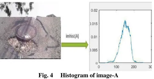
[image:4.612.44.289.56.187.2]Hence for comparing two images we take one of the properties of it and we go ahead, and for that histogram is used A histogram is a graphical representation of total values of your image. In other words it shows the amount of tones of particular brightness found in the image ranging from black (0 % brightness) to white (100 % brightness).
Fig. 4 Histogram of image-A
Here the fig 4 represent histogram of image-A. Histogram is obtained by function provided by matlab called imhist(A). In digital image representation the given image is divided into many pixels. Corresponding to each pixel there will be an intensity level associated with it practically we assign 256 levels
of intensity to an image i.e. we represent image intensity level ranging from 0-255 where 0 is black and 255 is white
Histogram of an image actually contains, In fig 5 it is the model of how histogram looks like. Here x axis is the intensity from 0-255 and y axis is no. of pixels for e.g. dark picture will have more no of pixel occupying lower intensity values here the peak value lies in left extreme region whereas white image has peak value of extreme right end. And in between the 0-255 is the gradient of intensities from black to white transition
Fig. 5 Histogram of an Image
VII. ADVANTAGESOFPROPOSEDSYSTEMS
The proposed system will have following functionalities,
1. Visible to other public residing in that locality
2. System to report similar problem multiple times by multiple citizen and act accordingly
3. No manual efforts to report the problem, Problem reporting possible just by clicking a picture (Auto detection of attributes, Auto Location detection)
4. Facility for citizen to go to higher authority if his complaint is not acted upon
5. Impartial final judgement delivered by the system 6. Mechanism to enable the system to record attributes of problem
7. Easily Accessible system even when internet is not detected
8. Every Infrastructure should be able to get reported to the concerning facility i.e. ULB or PWD
VIII. METHODOLOGY
1. To implement a new features the developers need to lose only the work of a few days, or even only hours, to roll back and implement it.
[image:4.612.39.291.539.668.2]newly affected or removed based on feedback. This effectively gives the customers the finished system they want or need.
3. Both system developers and stakeholders alike, find they also get more freedom of time and options than if the the software was developed in a more rigid sequential way. Having option gives them the ability to leave important decision until more or better data or even entire hosting programs are available; meaning the project can continue to move forward without fear of reacting a sudden standstill.
IX. CONCLUSION
This Project will serve as a useful approach to detect and calculate the depth of the Pothole and reporting it. It will enable to create and maintain updated database of detected potholes. It serves as a helpful approach for the government authority. It reduces the time taken to manually search and locate potholes. Our goal is to provide an accurate information about the location of the Pothole spotted.
REFERENCES Paper References
[1] Pothole Detection System Using a Black-box Camera, Youngtae Jo and Seungki Ryu, Highway Research Institute, Korea Institute of Civil Engineering and Building Technology.
[2] Pothole detection in asphalt pavement images, Author links open overlay panel Christian Koch Federal Highway Administration, LTPP – Beyond FY 2009: What needs to be done? Technical Report.
[3] Analysis of Fatal Road Traffic Accidents in a Metropolitan City of South India P. Shruthi, V.T. Venkatesh, B. Viswakanth, C. Ramesh, P.L Sujatha, I. R. Dominic.
Web References
[4] Why is the state of roads in India so poor? Who is responsible for overseeing and maintaining the quality of roads?, Retrieved on October 27, 2017, from https://www.quora.com/Why-is-the-state-of-roads-in-India-so- poor-Who-is-responsible-for-overseeing-and-maintaining-the-quality-of-roads (goo.gl/ykcGkN).
[5] Poor condition of roads make life miserable, Retrieved on October 27, 2017, from https://timesofindia.indiatimes.com/city/chandigarh/Poor-condition-of-roads-make-life-miserable/articleshow/170287.cms
(goo.gl/LVDsKV).
[6] Apps to report potholes launched, Retrieved on October 27, 2017, from
https://www.autocarindia.com/car-news/apps-to-report-potholes-launched-402756 (goo.gl/x66xTW).
AUTHORS
First Author – Ingale Hitesh, M.H. Saboo Siddik College of Engineering, Information Technology Department, University Of Mumbai, India
Second Author – Electricwala Faraaz, M.H. Saboo Siddik College of Engineering, Information Technology Department, University Of Mumbai, India
Third Author – Shaikh Abdul Sattar, M.H. Saboo Siddik College of Engineering, Information Technology Department, University Of Mumbai, India