Fitting Of Gompertz Model Between Rainfall
And Ground Water Levels – A Case Study
Raju Sake 1, P. Mohammed Akhtar2
1
Research Scholar, Department of Statistics, Sri Krishnadevaraya University, Anantapuramu,(A.P), India 2
Professor, Department of Statistics, Sri Krishnadevaraya University, Anantapuramu,(A.P), India
Abstract —Time series analysis and its prediction itself involve tedious activities, such as their preprocessing, their transformation, and adjustment of various parameters and associated models etc. In this paper we have considered the Statistical Analysis of Rainfall and Ground Water Levels in Anantapuramu District of Andhra Pradesh. It deals with the application of Time Series model to analyze and predict Rainfall (RF) and Ground water levels (GWLs) in Anantapuramu district based on the data collected from January 2007 to December 2016. Through with Gompertz model for the purpose of analysis the district is divided into five zones. We have estimated the Gompertz model values and compared them by using the data. Further, validation of the fitted model identified the best suitable zone. i.e., least Mean Square Error (MSE) value of the zone and forecast on the Rainfall and Ground water levels of this district. We also find the relationship between rainfall and ground water levels in this district and conclusions are drawn based on the results obtained.
Keywords —Rainfall, Ground Water Level, Gompertz model, Validation of the model, prediction.
---
I. INTRODUCTION
According to Ya-lun Chou “A time series may be defined as a collection of readings belonging to different time periods, of some economic variable or composite of variables.” Mathematically, a time series is defined by the functional relationship
𝑈𝑡 = 𝑓(𝑡) ……… (1.1)
Where 𝑈𝑡 is the value or the phenomenon (or variable) under consideration at time 𝑡.
For example, the temperature (𝑈𝑡) of a place on different days (𝑡) of the week; rainfall (𝑈𝑡) of a place on different
days (𝑡) of the month; ground water levels (𝑈𝑡) of a place on different months (𝑡) of the year etc[3,4,5,6,11].
Named after Benjamin Gompertz (1779-1865) this is a sigmoid function. It is a useful model for time series in which growth is very slow in the initial and final stages. It is also useful in describing the growth of tumors, acquisition of mobile phones, and population in a confined space. Etc.
Gompertz Curve is used in actuarial work and sometimes in business and population forecasting as a growth curve. The function was originally designed to describe human mortality, but since it has been modified to be applied in biology, with regards to detailing populations [7, 8].
Water is the main source for any developmental activity. Water resources/water facilities are measured through Rainfall and Ground water levels in any region [9, 10,12]. Identifying the importance of Ground water level a time series analysis is proposed to analyze the data relating to Anantapur district because this district has been a drought prone area since so many decades [13]. In order to forecast Ground water levels of this district, at an attempt is made to predict Rainfall and Ground water levels through Modified exponential model [14].
For the present work the data collected, the data relating to January to December months from 2007 to 2016 is considered for the purpose of analysis of this paper on both the variables i.e. Ground Water Level and Rainfall. Further Anantapuramu district consisting of 63 mandals is divided into five Revenue Divisions for the administrative convenience and hence for the analysis these five Revenue Divisions are considered as five zones and are given in the following table along with their respective Mandals [1,2,13,14].
Table-1.1
Zonal-wise (Revenue division) of mandals in Anantapuramu District
.
Sl.No
Zone-I Anantapuramu
RD
Zone-II Penukonda RD
Zone-III Kadiri RD
Zone-IV Kalyandurg
RD
Zone-V Dharmavaram RD
1 Anantapuramu Agali Amadagur Beluguppa Bathalapalli
2 Atmakur Amarapuram Bukkapatnam Bommanahal C.K.Palli
3 B.K.Samudram Chilamathur Gandlapenta Brahmasamudram Dharmavaram
4 Garladinne Gorantla Kadiri D.Hirehal Kanaganipalli
5 Gooty Gudibanda Kothacheruvu Gummaghatta Mudigubba
6 Guntakal Hindupur N.P.Kunta Kalyandurg Ramagiri
7 Kudair Lepakshi Nallacheruvu Kambadur Raptadu
8 Narpala Madakasira Nallamada Kanekal Tadimarri
9 Pamidi Parigi O.D.Cheruvu Kundurpi
10 Peddapappur Penukonda Puttaparthi Rayadurg
11 Peddavadugur Roddam Talupula Settur
12 Putlur Rolla Tanakal
13 Singanamala Somandepalli
14 Tadipatri
15 Uravakonda
16 Vajrakarur
17 Vidapanakal
18 Yadiki
19 Yellanur
Total(63) 19 13 12 11 8
Similarly, zonal wise Piezometer Points are also provided in the following table, from which GWLs are measured.
Table-1.2
Zonal-wise of Piezometer Points in Anantapuramu District.
Zone-I Anantapuramu
RD
Zone-II Penukonda
RD
Zone-III Kadiri
RD
Zone-IV Kalyandurg
RD
Zone-V Dharmavaram
RD Piezometer
Points(194) 54 50 31 32 27
The data is collected on Average Rainfall and Average Ground Water Levels are given in the following Table-1.3 for a ready reference.
Table-1.3
Average Rainfall and Average Ground water levels data from 2007 to 2016
Year
Zone-I Zone-II Zone-III Zone-IV Zone-V
RF (in mm)
GWL RF
(in mm)
GWL RF
(in mm)
GWL RF
(in mm)
GWL RF
(in mm)
GWL
2007 65.60 10.57 58.20 22.58 67.20 14.23 52.00 14.97 60.50 17.03
2009 45.40 12.17 50.60 17.53 46.30 11.08 57.10 9.58 38.70 10.24
2010 53.90 12.74 71.50 15.02 70.80 12.03 64.60 8.58 56.30 11.79
2011 39.50 12.69 42.30 15.20 48.90 11.48 31.80 8.93 36.60 12.84
2012 43.20 14.98 43.40 20.49 45.30 16.08 40.50 13.76 41.90 13.22
2013 35.00 15.94 52.30 23.03 47.10 18.69 34.80 16.98 38.10 14.30
2014 31.10 15.87 30.30 23.40 27.10 21.16 37.10 18.92 22.80 16.30
2015 44.10 14.90 62.60 26.88 66.30 25.80 46.00 19.26 54.30 17.66
2016 33.50 15.57 33.40 27.27 32.30 15.35 25.70 19.51 30.10 16.15
II. STATISTICAL ANALYSIS
Some of the Preliminary Statistical analysis is done for the data provided in the above table -1.3, such as yearly averages of Rainfall and Ground water levels are calculated and Karl-Pearson‟s Correlation Coefficient ( r ) is calculated between Average Rainfall(X) and Average Ground water levels (Y) Zonal wise by using the following formula,
r = 𝒄𝒐𝒗(𝒙,𝒚)
𝒗 𝒙 .𝒗(𝒚) ….(2.1)
and are given in the following Table-2.1.
Table-2.1
Correlation Coefficient between Average Rainfall and Average Ground Water Level.
Years Zone-I Zone-II Zone-III Zone-IV Zone-V
2007-2016 -0.84 -0.26 -0.20 -0.58 -0.23
By studying the above Correlation Coefficients we can observed that all the Correlation Coefficients are negative, that is the relation between Rainfall and Ground Water levels is negative, that is, if Rainfall is increases the Ground water level decreases, it is true, because the depth of the water level will decrease. By observing the Correlation coefficients in the above Table-2.1 in Zone-I and Zone-IV they are strongly negatively related, as the other Zones are weakly negatively related. We observed that in Zone-I and Zone-IV additional to rainfall, other water resources like, High Level Canal (HLC) in these zones that also helps to improve the Ground water level.
To forecast Rainfall and Ground Water Levels through Gompertz model for different zones, we consider
The Gompertz Model 𝒚𝒕= 𝒌 ∗ 𝒂𝒃
𝒕
.……(2.2)
log𝑒𝑦𝑡= log𝑒𝑘 + 𝑏𝑡log𝑒𝑎 ..…...(2.3)
𝑌𝑡= 𝐾 + 𝐴𝑏𝑡 …….(2.4)
𝑎 = 𝑎𝑛𝑡𝑖𝑙𝑜𝑔 𝐴 , 𝑘 = 𝑎𝑛𝑡𝑖𝑙𝑜𝑔(𝐾) …….(2.5)
Where 𝑏 = (𝑦𝑦3−𝑦2
2−𝑦1)
( 1
𝑡2−𝑡1) ……..(2.6)
𝐴 = log𝑒𝑎 = 𝑎 =
(𝑦2−𝑦1)2
(𝑦3−2𝑦2+𝑦1)∗ (
𝑦2−𝑦1 𝑦3−𝑦2)
( 𝑡1
𝑡2−𝑡1) ……(2.7)
𝑘 = log𝑒𝑘 = (𝑦1𝑦3−𝑦2
2)
Here, 𝑡1, 𝑡2, 𝑡3 are three selected time points and
𝑦1, 𝑦2, 𝑦3are their correspondence rainfall or ground water level values it‟s taken.
To fit the above Gompertz model and to estimate the values of the parameters „a‟, „b‟ and „k‟ by solving the related normal equations and following trend curve is fitted for the data given in table 1.3 and fitted model is given below.
The fitted Gompertz model for Average RF and Average GWLs:
A: For Rainfall
Zone-I
Gompertz Curve log𝑒𝑦𝑡= 2.62 + 1.63 ∗ (0.92)𝑡
Zone-II
Gompertz Curve log𝑒𝑦𝑡= 3.03 + 2.02 ∗ (0.81)𝑡
Zone-III
Gompertz Curve log𝑒𝑦𝑡= 4.46 + −0.17 ∗ (1.27)𝑡
Zone-IV
Gompertz Curve log𝑒𝑦𝑡= 3.58 + 1.44 ∗ (−0.61)𝑡
Zone-V
Gompertz Curve log𝑒𝑦𝑡= −0.03 + 4.57 ∗ (0.95)𝑡
B: For Ground water levels
Zone-I
Gompertz Curve log𝑒𝑦𝑡= 5.18 + −3.05 ∗ (0.97)𝑡
Zone-II
Gompertz Curve log𝑒𝑦𝑡= 2.90 + 0.10 ∗ (−1.12)𝑡
Zone-III
Gompertz Curve log𝑒𝑦𝑡= 2.12 + 0.05 ∗ (1.43)𝑡
Zone-IV
Gompertz Curve log𝑒𝑦𝑡= 2.35 + 0.02 ∗ (−1.55)𝑡
Zone-V
Gompertz Curve log𝑒𝑦𝑡= 3.37 + −1.46 ∗ (0.89)𝑡
Gompertz Curve 𝑦 𝑡 = 𝑒 (log𝑒𝑦𝑡) here substitutes the 𝒍𝒐𝒈𝒆𝒚𝒕values for required estimated Gompertz curve values.
III. VALIDATION OF THE FITTED MODEL
Table-3.1
Estimated Average RF 𝒚 for Gompertz Curve
.
Table-3.2
Estimated Average GWL 𝒚 for Gompertz Curve.
Year Zone-I Zone-II Zone-III Zone-IV Zone-V
Actual Estimates Actual Estimates Actual Estimates Actual Estimates Actual Estimates
2007 10.57 9.21 22.58 16.28 14.23 8.94 14.97 10.18 17.03 7.92
2008 9.96 10.07 20.73 20.70 9.27 9.21 10.88 11.02 9.09 9.21
2009 12.17 11.02 17.53 15.80 11.08 9.68 9.58 9.78 10.24 10.49
2010 12.74 11.82 15.02 21.33 12.03 10.28 8.58 11.82 11.79 11.59
2011 12.69 12.94 15.20 15.18 11.48 11.25 8.93 8.76 12.84 12.81
2012 14.98 14.15 20.49 22.20 16.08 12.81 13.76 13.87 13.22 14.01
2013 15.94 15.03 23.03 14.59 18.69 15.33 16.98 6.82 14.30 15.33
2014 15.87 16.44 23.40 23.34 21.16 19.89 18.92 20.49 16.30 16.44
2015 14.90 17.46 26.88 13.74 25.80 29.08 19.26 3.74 17.66 17.46
2016 15.57 18.54 27.27 24.78 15.35 49.90 19.51 51.94 16.15 18.54
In the above tables-3.1 and 3.2 for the validation of the model Mean Square Errors (MSE‟s) are calculated zone wise by considering
MSE = (𝒚 − 𝒚 )𝟐 …..(3.1) Where y represents actual or observed values given in table-1.3 and 𝑦 is the estimated values through fitted Gompertz model is given in tables-3.1 and 3.2 using fitted Gompertz model respectively. MSE‟s were calculated and are given in the following Table-3.3.
Table-3.3
MSE’s for Average RF- Gompertz Model.
Type of the Model
Zone-I Zone-II Zone-III Zone-IV Zone-V
Gompertz 406.11 4614.16 3097.61 3015.10 2615.71
Table-3.4
MSE’s for Average GWL – Gompertz Model.
Type of the Model
Zone-I Zone-II Zone-III Zone-IV Zone-V
Gompertz 21.31 335.52 1261.12 1431.81 90.57
By Comparing MSE‟s for RF and GWLs through Gompertz model under consideration, for RF of zone-I is least and GWLs for zone-I Gompertz model is the most suitable model because MSEs for zone-I is least. Next to zone-I, zone-V has least MSEs. Thus next to zone-I for zone-V Gompertz model is best suitable for the RF and GWLs. Further, the behaviors of RF and GWL through this model i.e. Gompertz model in different Zones are represented in the following Figure-3.1. Similar conclusions can be drawn from the following graphs also.
Year Zone-I Zone-II Zone-III Zone-IV Zone-V
Actual Estimates Actual Estimates Actual Estimates Actual Estimates Actual Estimates
2007 65.60 61.56 58.20 106.70 67.20 69.41 52.00 14.88 60.50 74.44
2008 53.90 55.15 77.90 78.26 65.20 66.02 61.30 60.95 62.70 59.15
2009 45.40 48.91 50.60 60.34 46.30 60.95 57.10 25.79 38.70 49.40
2010 53.90 44.26 71.50 49.40 70.80 55.70 64.60 43.82 56.30 39.25
2011 39.50 40.45 42.30 42.10 48.90 49.40 31.80 31.82 36.60 32.79
2012 43.20 36.97 43.40 36.60 45.30 42.52 40.50 38.47 41.90 28.50
2013 35.00 34.12 52.30 32.79 47.10 34.81 34.80 34.47 38.10 23.81
2014 31.10 31.50 30.30 30.27 27.10 27.39 37.10 36.97 22.80 19.89
2015 44.10 29.67 62.60 27.94 66.30 20.09 46.00 35.52 54.30 17.29
Fig-3.1
Behavior of RF and GWL actual and Gompertz Curve Forecasts in Zone –I, II, III, IV and V
Note: In the above graphs x-axis represents years in the last decade i.e. from 2007 to 2016. On y-axis RF measured in Mille Meters or Average GWLs measured in Meters.
IV. FURTHER STATISTICAL ANALYSIS
Now we proceed to analyze the given estimates in tables-3.1 and 3.2 using ANOVA two- way classification by considering rows as different years and columns as different zones and the following Null Hypothesis are formed and tested.
0 20 40 60 80
1 3 5 7 9
Zone-I Actual Average RF(Ƴ) Zone-I Estimated Average RF(Ŷ) 0 50 100 150
1 3 5 7 9
Zone-II Actual Average RF(Ƴ) Zone-II Estimated Average RF(Ŷ) 0 20 40 60 80
1 3 5 7 9
Zone-III Actual Average RF(Ƴ) Zone-III Estimated Average RF(Ŷ) 0 20 40 60 80
1 3 5 7 9
Zone-IV Actual Average RF(Ƴ) Zone-IV Estimated Average RF(Ŷ) 0 20 40 60 80
1 3 5 7 9
Zone-V Actual Average RF(Ƴ) Zone-V Estimated Average RF(Ŷ) 0 5 10 15 20
1 3 5 7 9
Zone-I Actual Average GWL(Ƴ) Zone-I Estimated Average GWL(Ŷ) 0 10 20 30
1 3 5 7 9
Zone-II Actual Average GWL(Ƴ) Zone-II Estimated Average GWL(Ŷ) 0 20 40 60
1 3 5 7 9
Zone-III Actual Average GWL(Ƴ) Zone-III Estimated Average GWL(Ŷ) 0 20 40 60
1 3 5 7 9
Zone-IV Actual Average GWL(Ƴ) Zone-IV Estimated Average GWL(Ŷ) 0 10 20
1 3 5 7 9
H01: There is no significant difference between different years of Average RF in Anantapuramu District. H02 : There is no significant difference between Average RF of different zones in Anantapuramu District.
H03: There is no significant difference between different years of Average Ground Water Levels in Anantapuramu District.
H04 : There is no significant difference between Average Ground Water Levels of different zones in Anantapuramu District.
Table-4.1
ANOVA Two-way Table for RF
Source of variation d.f S.S M.S.S F-cal
Rows (years)
9 9885.685 1098.409 7.13**
Columns (Zones)
4 1253.674 313.4186 2.03*
Error 36 5538.276 153.841
Total 49 16677.64
By comparing F-calculated value of Rows (Years) with F-critical value at 5 % level of significance (l.o.s) we reject the H01 i.e. There is a significant difference between different years of Average RF in Anantapuramu District. Similarly by comparing F-calculated value of Columns (Zones) with F-critical value at 5 % level of significance (l.o.s) we accept the H02 i.e. There is no significant difference between different zones of Average RF in Anantapuramu District.
Table-4.2
ANOVA Two-way Table for GWL
Source of variation d.f S.S M.S.S F-cal
Rows (years)
9 1930.554 214.506 4.70*
Columns (Zones)
4 235.6598 58.91496 1.29*
Error 36 1641.98 45.61056
Total 49 3808.194
By comparing F-calculated value of Rows (Years) with F-critical value at 5 % level of significance (l.o.s) we reject the H01 i.e. There is a significant difference between different years of Average GWL in Anantapuramu District. Similarly by comparing F-calculated value of Columns (Zones) with F-critical value at 5 % level of significance (l.o.s) we accept the H02 i.e. There is no significant difference between different zones of Average GWL in Anantapuramu District.
Since F-cal value related to rows(years) in RF and rows(years) in GWL is high so there is a necessity for Critical Difference (C.D) Test for sub-grouping various years using the following formula[11][12].
C.D. = 2 × 𝐸𝑟𝑟𝑜𝑟 𝑀. 𝑆. 𝑆/𝑚 × t0.01 for error d.f. in tables -4.1 and 4.2 ...…(4.1) Where 𝑚 represents number of estimates in each zone and as well as year.
V. CRITICAL DIFFERENCE (C.D) TEST: Average RF for Years
Table-5.1
Year wise Aggregate Average RF for Gompertz Curve estimates
Year 2007 2008 2009 2010 2011 2012 2013 2014 2015 2016
Average 65.39 63.90 49.07 46.48 39.31 36.61 32 29.20 26.10 23.73
Table 5.2
If we can arranged Ascending Order
Year 2016 2015 2014 2013 2012 2011 2010 2009 2008 2007
Average 23.73 26.10 29.20 32 36.61 39.31 46.48 49.07 63.90 65.39
S.E = 2 × 𝐸𝑟𝑟𝑜𝑟 𝑀. 𝑆. 𝑆/𝑚 = 7.84
1% l.o.f C.D = 2.58×7.84 = 20.22 __________________________________________
________________________________________
2016 2015 2014 2013 2012 2011 2010 2009 2008 2007 ________________________________
_____________________________
Above notation indicates that 2016, 2015, 2014, 2013, 2012 ,2011 years Average RF come under one category and 2015, 2014, 2013, 2012, 2011 years Average RF and 2014, 2013, 2012, 2011, 2010, 2009 years Average RF and also 2010, 2009, 2008, 2007 come under another category because there is no Significant Difference in average RF. These years are ranked based on their respective Average RF.
CRITICAL DIFFERENCE (C.D) TEST: Average GWL for Years
Table-5.3
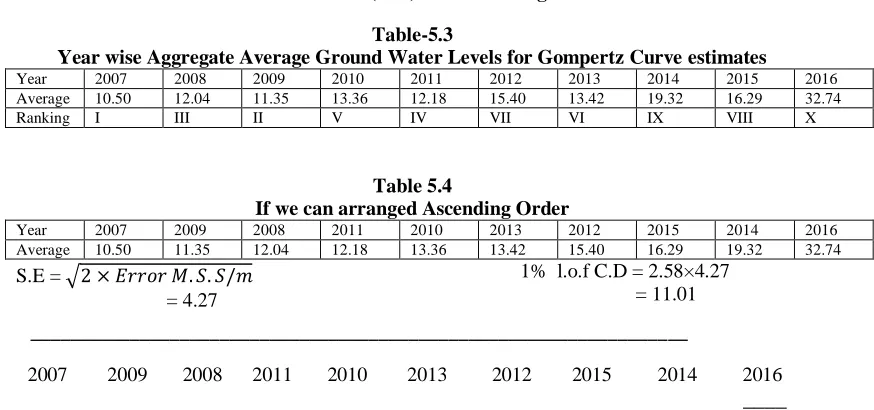
Year wise Aggregate Average Ground Water Levels for Gompertz Curve estimates
Year 2007 2008 2009 2010 2011 2012 2013 2014 2015 2016
Average 10.50 12.04 11.35 13.36 12.18 15.40 13.42 19.32 16.29 32.74
Ranking I III II V IV VII VI IX VIII X
Table 5.4
If we can arranged Ascending Order
Year 2007 2009 2008 2011 2010 2013 2012 2015 2014 2016
Average 10.50 11.35 12.04 12.18 13.36 13.42 15.40 16.29 19.32 32.74
S.E = 2 × 𝐸𝑟𝑟𝑜𝑟 𝑀. 𝑆. 𝑆/𝑚 = 4.27
1% l.o.f C.D = 2.58×4.27 = 11.01
__________________________________________________________________
2007 2009 2008 2011 2010 2013 2012 2015 2014 2016
____
Above notation indicates that 2007, 2009, 2008, 2011, 2010, 2013, 2012, 2015, 2014 Average GWLs come under one category and 2016 Average GWLs, come under another category because there is no Significant Difference in average ground water levels. These years are ranked based on their respective average GWLs.
ACKNOWLEDGEMENTS
AUTHORS PROFILE
Mr. Raju Sake is doing research in Statistics in the Department of Statistics, S.K. University, Anantapur, for his Ph.D.
Prof. P.Mohammed Akhtar, working as Professor of Statistics, in the Department of Statistics, S.K. University, Anantapur, for the last 33 years. He has published more than 40 research papers in various journals. He produced 6 Ph.D‟s under his guidance. His main research work focuses on Quality Control, Time Series Analysis, and Data Mining.
REFERENCES
[1] A.H. Nury, M. Koch and M.J.B. Alam, “Time Series Analysis and Forecasting of Temperatures in the Sylhet Division of Bangladesh”,
Proceedings of 4th International Conference on Environmental Aspects of Bangladesh, Fukoka, Japan, 2013.
[2] D. Machiwal and M.K. Jha, “Time Series Analysis of Hydrologic Data For Water Resources Planning and Management“: A Review. J.
Hydrol, Hydromech, 54(3): 237-257, 2006.
[3] D.C Montgomery, L.A Johnson,” Forecasting and time series analysis”. McGraw-Hill; 1976.
[4] G.E.P Box, G.M. & G.C Reinsel, “Time series analysis and forecasting and control”, 3rd ed., Englewood Cliffs, N.J. Prentice Hall, 1994. [5] G.E.P Box, G.M Jenkins, “Time Series Analysis, Forecasting and Control”, Holden-Day: San Francisco, 1976.
[6] G.E.P Box, G.M Jenkins, G.C Reinsel, ”Time series analysis: Forecasting and Control”. John Wiley and Sons; 2008. [7] J.D Hamilton, “Time series analysis”. Princeton University Press; 1994.
[8] Otnes RK, Enochson L. “Applied Time Series Analsis”, Vol. 1. New York: Wiley; 1978.
[9] S. Soltani, R. Modarres and S.S. Eslamian, “ The use of time series modeling for the determination of rainfall climates of Iran”.
International Journal of Climatology, 27: 819-829, 2007.
[10] S.A. Shamsnia, N. Shahidi, A. Liaghat, A. Sarraf and S.F. Vahdat, “ Modelling Of Weather Parameters ( Temperature, Rainfall And Humidity) Using Stochastic Methods. Internat. Conference on Environment and Industrial Innovation, IPCBEE, Singapore, 282-285, 2011.
[11] S.C. Gupta, V.K. Kapoor, “Fundamentals of Applied Statistics”. Sultan Chand & Sons; 2003.
[12] S.M. Ali, “Time Series Analysis of Baghdad Rainfall Using ARIMA method “Iraqi Journal of Science,54(4):1136-1142,2013.
[13] S. Raju, P. Mohammed Akhtar, “Time Series Analysis on Rainfall and Ground Water Levels Data – A Case Study”, International Journal of Scientific Research in Mathematics and Statistical Sciences Vol.6, Issue.1, pp.76-85, February (2019).
[14] S. Raju, P. Mohammed Akhtar, “Fitting of modified exponential model between rainfall and ground water levels: A case study”. International Journal of Statistics and Applied Mathematics 2019; 4(4): 01-06.