Bhawanpreet Kaur et al, International Journal of Computer Science and Mobile Applications, Vol.6 Issue. 2, February- 2018, pg. 95-99 ISSN: 2321-8363 Impact Factor: 5.515
ROBUST & HYBRID FEATURE
DESCRIPTION FOR OBJECT
DETECTION IN THE OCEAN IMAGERY
Bhawanpreet Kaur
1, Khushbu Cheetu
2 1M.Tech Scholar, 2Asst. Professor
Department of Computer Science Engineering, Indo Global College of Engineering 1
[email protected], [email protected]
ABSTRACT— In the latest accident, missing Malaysian aero plane (which went missing on the oceans) can’t be spotted by the satellites yet. This shows the lack in the technology of spotting the objects and marking the debris from the satellite images. The remote sensography techniques are always efficient in making the detection of such objects quite efficient. There are a number of objects, which kept floating in the oceans, for example, containers dropped from ships, garbage dropped by ships, objects dragged to the oceans by natural hazards like tsunami, twister, etc. The image segmentation can be combined with the object based and pixel based approaches in order to create a new hybrid approach to spot and analyze the objects floating in the oceans using the high quality satellite images.
KEYWORDS— Object detection, object recognition, Oceanography, Satellite Imagery, Deep Learning.
INTRODUCTION
This paper will review some of the state of the art technologies available (as well as their costs), describe how the underlying technology works, and explain how the systems can be implemented. Object detection is the technique of detection of the object type is sub-type of automatic computer vision. The oceanography is the largely growing research area for the detection and localization of the objects in the satellite imagery.
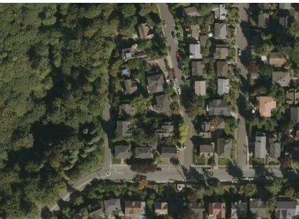
Figure 1: The semi-urban area’s satellite camera modules for surveillance in versatile domains
Bhawanpreet Kaur et al, International Journal of Computer Science and Mobile Applications, Vol.6 Issue. 2, February- 2018, pg. 95-99 ISSN: 2321-8363 Impact Factor: 5.515 produces the requirement of detection of such objects. The ocean imaging is done by the satellites and falls under the SAR or aerial imaging category. In this paper, the innovative method for the detection and recognition of the various types of objects in oceanographic imagery has been proposed, which evaluates the geographic, color and texture properties for the pattern visualization of the given objects.
Figure 2: The detection and marking of the geographic regions with intelligent algorithm
The proposed system can be used to find any physical object whose color pattern and shape can be specified (known). Proposed system will be produce accurate results than any existing object detection algorithm.
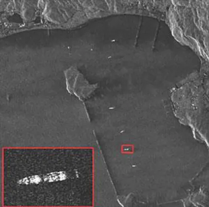
Figure 3: The example of ship and small oceanic object detection
The proposed model involves the historical data stored under the training data module for the recognition and localization of the desired objects in the wider oceanic space.
LITERATURE REVIEW
Bhawanpreet Kaur et al, International Journal of Computer Science and Mobile Applications, Vol.6 Issue. 2, February- 2018, pg. 95-99 ISSN: 2321-8363 Impact Factor: 5.515 recognition of the useful objects to extract the useful information. In the segmented objects, the shape-based, texture-based and other types of analytical modules are applied for the detection of the vessels and ship heads. Also the size of the detected object is determined in the overall covered area as well as its width and length. The contextual information has been utilized for the classification of the target objects.
Thomas H et. al. (2012) has worked towards the N-hard problem for the detection of debris in the ocean images. This model is made capable of detection of the low profile and smaller sizes debris items in oceanographic imagery. This scheme is applicable upon the satellite radar imagery data, remote sensing image database and other multispectral imagery collected from the high resolution images. The multi-layered analysis has been performed over the image data for the finalization of the area with the floating debris.
Shivani Agarwal et. al. (2013) has studied the possibility of the multispectral analysis for the geographic and biodiversity for the estimation of the various dense and sparse green areas in the city of Bangalore, India. The pixel density based estimation is utilized for the formation of the connected components to estimate the green belt regions in the urban imagery collected from the various types of imagery datasets. The colour based features plays the important in detection and localization of the areas under the green belt to estimate the overall volume of the green areas in the given segment of the urban area.
Nagendra, Harini et. al (2008) has worked on the estimation and assessment of the biodiversity among the developed area (i.e. urban and semi-urban areas), which has been aimed to the monitoring of the green belt area. This model is particularly designed for the monitoring of the reduction of the green belt areas in the target areas, which helps to reduce or optimize the activities destroying the green belt areas.
Peter Hofmann et. al(2004) – presents that Remote sensing from airborne and space borne platforms provides valuable data for mapping, environmental monitoring, disaster management and civil and military intelligence.
FINDINGS OF LITERATURE REVIEW
The existing models have been deeply analyzed for the advantages and disadvantages related to their methodology and functionality. The existing models have been studied for the functional limitations and their possible improvements. In the following steps, the limitations can be explained in detail:
1. The existing model is based upon the vehicular detection methods using the probabilistic neural network. The accuracy of the existing model has been recorded lower nearly at 61.75% measured by similarity and 69.38% measured by F1-Measure error. The accuracy of the system can be improved using the deep neural network along with the feature compression for the faster processing.
2. The block estimation procedure along with neural network makes the whole process slower, because of the slider window fashion based object detection and classification. The speed of the system can be improved by using the block feature compression method using the ship or oceanic object shape specific localized feature descriptor for optimization of the elapsed time.
3. The existing model is capable of ship detection only and does not offer any of the mechanism for ship detection and classification. The exiting model does not perform any kind of ship classification. The system does not create the ship or other object based analytical framework for the object detection, classification and time based analytical study.
METHODOLOGY
Bhawanpreet Kaur et al, International Journal of Computer Science and Mobile Applications, Vol.6 Issue. 2, February- 2018, pg. 95-99 ISSN: 2321-8363 Impact Factor: 5.515 etc. There are plenty of object floating within the oceans, as an example, containers dropped accidently from ships, garbage dropped by people or by ships, objects dragged to the oceans by natural hazards like tsunami, twister, etc. The colour and texture based approaches are often combined to make a replacement hybrid approach to identify and analyze the objects floating within the oceans utilization the prime quality satellite or aerial image data for oceans.
CONCLUSION
In the latest accident, missing Malaysian Aero-plane (which went missing on the oceans) could not be spotted by the satellites yet. This shows the lack in the technology of spotting the objects and marking the debris from the satellite images. In the existing solutions, the neural network has been used for the vehicle detection in the high and low-bit rate satellite or aerial imagery. The existing method is based upon the local binary pattern (LBP) feature descriptor, which is used to specify the textural properties of the object. The LBP feature descriptor is a binary feature descriptor, which converts the object visuals into the binary matrix, which is further utilized by the classification algorithm to produce the decision logic. The support vector machine (SVM) based classification model has been utilized in the existing scheme over the LBP features. The existing model has been recorded with lower levels of precision parameters due to the high rate of false positive cases. The overall accuracy of the existing system is reduced due to the high false positive rate (FPR). The LBP feature descriptor does return the eligible features for every input object, which diminishes the object details while converted to binary. The feature description must be improved in order to improve the overall accuracy of the system.
REFERENCES
[1] Stefan Craciun, Gongyu Wang, Alan D. George, Herman Lam, Jose C. Principe, “A Scalable RC Architecture for Mean-Shift Clustering”, ASAP, pp. 370-374, IEEE 2013.
[2] Shivani Agarwal, Lionel Sujay Vailshery, Madhumitha Jaganmohan and Harini Nagendra, “Mapping Urban Tree Species Using Very High Resolution Satellite Imagery: Comparing Pixel-Based and Object-Based Approaches”, ISPRS, pp. 220-236, IEEE, 2013.
[3] Nagendra, H.; Lucas, R.; Honrado, J.P.; Jongman, R.H.G.; Tarantino, C.; Adamo, M.; Mairota, P. Remote sensing for conservation monitoring: Assessing protected areas, habitat extent, habitat condition, species diversity and threats. Ecol. Indic.
2012, doi:10.1016/j.ecolind.2012.09.014.
[4] Boyd, D.S.; Foody, G.M. An overview of recent remote sensing and GIS based research in ecological informatics. Ecol. Inform. 2011, 6, 25–36.
[5] Gairola, S.; Proches, S.; Rocchini, D. High-resolution satellite remote sensing: A new frontier for biodiversity exploration in Indian Himalayan forests. Int. J. Remote Sens. 2012, 34, 2006–2022.
[6] Nagendra, H.; Rocchini, D. High resolution satellite imagery for tropical biodiversity studies: The devil is in the detail. Biodivers. Conserv. 2008, 17, 3431–3442.
[7] Wang, K.; Franklin, E.S.; Guo, X.; Cattet, M. Remote sensing of ecology, biodiversity and conservation: A review from the perspective of remote sensing specialists. Sensors 2010, 10, 9647–9667.
[8] Benz, U.C.; Hofmann, P.; Willhauck, G.; Lingenfelder, I.; Heynen, M. Multiresolution, object oriented fuzzy analysis of remote sensing data for GIS-ready information. ISPRS J. Photogramm. 2004, 58, 239–258.
[9] Blaschke, T. Object based image analysis for remote sensing. ISPRS J. Photogrammm. 2010, 62, 2–16.
Bhawanpreet Kaur et al, International Journal of Computer Science and Mobile Applications, Vol.6 Issue. 2, February- 2018, pg. 95-99 ISSN: 2321-8363 Impact Factor: 5.515 [11] Liu, Ge, Yasen Zhang, Xinwei Zheng, Xian Sun, Kun Fu, and Hongqi Wang. "A new method on inshore ship detection in high-resolution satellite images using shape and context information." Geoscience and Remote Sensing Letters, IEEE 11, no. 3 (2014): 617-621.
[12] Yang, Feng, Qizhi Xu, Feng Gao, and Lei Hu. "Ship detection from optical satellite images based on visual search mechanism." In Geoscience and Remote Sensing Symposium (IGARSS), 2015 IEEE International, pp. 3679-3682. IEEE, 2015.
[13] Tang, Jiexiong, Chenwei Deng, Guang-Bin Huang, and Baojun Zhao. "Compressed-domain ship detection on spaceborne optical image using deep neural network and extreme learning machine." Geoscience and Remote Sensing, IEEE Transactions on 53, no. 3 (2015): 1174-1185.
[14] Yang, Feng, Qizhi Xu, Feng Gao, and Lei Hu. "Ship detection from optical satellite images based on visual search mechanism." In Geoscience and Remote Sensing Symposium (IGARSS), 2015 IEEE International, pp. 3679-3682. IEEE, 2015.