Abstract
Nature and history are integrated in the rural landscape and they summarize the infinite configurations of the local heritage. The symbiotic relationship between the environment and the rural nature of the sites is deposited on the centuries in a partnership that is an expression of identity and, with the exception of few areas that can still be considered whole natural, the current configuration of the territory is not the result of a spontaneous evolution, but it is a gradual adjustment operation and exploitation of local resources. The exploitation of water resources in rural purposes is one of the most ancient activities, the management of water resources has always been a work of vital importance for the survival and development of rural life, by developing and by perfecting techniques it has left a sign in the way of raising, in the type of crops and in the organization of rural settlements. The elements that are necessary for the control and exploitation of water resources vary a lot from place to place for the area's topography and the availability of the resource itself. We want to highlight certain constructive elements that derive their being from the need of exploitation of water resources, that influence the configuration of the landscape of our country as an iconography funded in the memory of places.
Keywords: rural landscape, water costruction, country iconography, water resources
The Rural Landscape as Heritage
The agricultural landscape is the product of the authentic culture and human nature. In the landscape, both in form and in the elements that make up the territory, as it presents itself, nature and history combine and summarize the endless interventions that are layered over time.
The configurations of the landscape are as diverse as there are different measures to adapt to the needs of rural communities that have worked for centuries in the territory modifications, accommodations and cropping systems. This overlap has led to the genesis of characters, meaning, usefulness, problems, through an evolutionary process in the synthesis of event and place, establishing a clear identity. The landscape is defined, then, as the set of natural and anthropogenic events, product of culture and social
relations, the spatial and temporal dimensions, fusion of historical memory and the presenti.
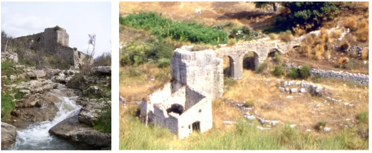
The symbiotic relationship between the environment and the rural nature of this area is settled over the centuries in a partnership that is itself an expression of identity; with the exception of a few areas that can still be considered to be purely natural, the current configuration of the territory is not the result of a spontaneous evolution, but a gradual process of adaptation and enhancement of local resources (Figg. 1-2).
1
Fig. 1-2: Water mill in the Cilento. The Perfect Integration between Construction and Natural Landscape
Reclamation or correction of the hydro-geological maintain a close and intimate bond with the land and its constraints. The crops, generated by the necessity of adaptation to the morphology of the soil, from destination to different varieties of crops, by the different exposure, from the fractionation land and the mode of water supply, has determined, in time, the texture of the territory characterized by a rich and varied plot, where the absence of a precise geometric pattern is associated with the apparent disorder of the work of human.
Outdated by now the meaning of the natural landscape as an area that has not changed for the work of man, we can assume that the entire land space has been explored and known in its physical aspects and there is no definition of the modern landscape that does not take into account the human component.
The word "culture" has its etymology, Latin colere, the meaning of living that is inseparable from grow, caring, worship and grace, in other words, of being. So living means taking care of the places through the ways of building and cultivating, recognizing and respecting the genius loci, which means to assume that in every place the physical component and human come together in a unique inseparable. If, therefore, we can assume that every landscape has the meaning of a cultural centre, every alteration of its formal and symbolic identity will result in an imbalance in the system of cultural identification and the process of recognition of communality between a particular form of culture and the set geo - environmental context in which life has taken.
The agricultural settlement are the main structure of the landscape as centres of organization of rural life; buildings for agricultural activities are an integral part of the landscape, mirror and witness for centuries of exploitation of local resources; the peculiarities and own use of the sites have given rise to a wide variety of shapes and colours of the building elements that link human activity to the context, through a dynamic process that, due to the evolution of considerable agricultural techniques, often brings these elements to become obsolete and therefore no longer maintained.
Fig. 3-4-5-6-7: Hydraulic Constructions Employing Traditional Local Materials
In flat terrain, although the characteristics of the different places and historical events have led to hydraulic arrangements and different cropping systems, generally the warping of the soil is characterized by a regular subdivision of plots, mainly corresponding to the different land ownership, which overlaps in a more or less specific to the network of rural paths and the system of the ditches. The latter have irrigated function, both adduction of the water, both of collection and regimentation of rainwater.
The soils in the slope are marked by oriented accommodations to correct or compensate for the inconvenience caused to the slope; the most widespread types of sorting are: terrace, banks and large steps. Finally, the cultivations of hilly terrain are not tied to particular works of hydraulic arrangements or compensation for the rugged nature of the land, in such contexts, the most widely used types of sorting are: cavalcapoggio, girapoggio and rittochinoii.
The Relationship between Agricultural Activity and Water
Water as a resource is a dynamic ever-changing state according to its natural cycle. During this cycle the waters serve multiple functions and are used for multiple purposes by man for domestic use, energy production, agricultural use, industrial, sporting, recreational, or scenic and decorative. The exploitation of water resources in rural purposes is one of the oldest activities; the management of water resources has always been a work of vital importance for the survival and development of rural activities, developing and perfecting techniques that have left their mark both in the way of cultivating that in the type of crops grown and the organization of rural settlements.
Water, like all natural resources, may constitute, as well as a great resource also a potential for harm if not properly regimented; therefore must be a distinction between the actions aimed at better use of water and the advocacy and protection from damage that would be harmful to crops and the rural settlements in general.
The utilization of water resources in agriculture is designed to following activities: • Drinking water,
• Watering, • Irrigation,
of the diversity of places but also the history and customs that in time produced different cultures; it would be difficult to classify and to compare the solutions developed for the exploitation of water in agriculture, but here we want to pay attention on how these intervening to characterize the landscape, sometimes very significantly, thus representing the conjunction between the different forms of presence of water in nature and work of adaptation that man has developed for purposes of settlement and productive.
The Architecture for the Management of Water Resources in Rural Areas
The elements necessary for the control and exploitation of water resources differ from one place to another, not only because of the topography of the area but also to the availability of the resource in terms of location: surface, underground rail, underground groundwater. The type of availability, the method of procurement and the extent of the resource, the characteristics of the soil and climatic factors also affect the organizations culture.
We want to dwell on a few items that, being functional to the need for exploitation of water resources, contribute to determine the configuration of the rural landscape of our country according to an iconography that sedimented in memory of places.
It recognizes the elements of a traditional building capacity to integrate into the landscape due to the use of local materials and techniques that are reflected in the shades of colour and texture of the natural and man-made; it is also necessary to make a distinction between works that fit in a timely manner in the rural built and those which, although less recognizable, shape it according to new configurations.
Among the works of uptake and removal, containment, and those for the regimentation of water
(dams and leveesiii) are undoubtedly those of greatest environmental impact for both the transformations on
the appearance of the places and the changes that generate on the biological balance of flora and fauna. We are, in fact, used to the presence of these elements in the landscape that we perceive as "domesticated," and that we justify on the basis of basic needs for the survival of human and productive settlements; however, the increasing focus on the environmental impact of these works is paid not only to the protection of the natural hazard or conditions of the natural habitat, but also to minimize the effects of alteration of the landscape due to the presence of this works and the mutations that trigger. Similarly, the intake works,
whether they are from the sourceiv, from the river or lake, while affecting less extensive areas of the above,
configure the same as hydraulic works where very often the technical requirements of construction and operation exceed decisions aimed at protecting the landscape with the consequent inevitable sacrifice that produces impoverishment of local values.
The presence of wellsv and springsvi is linked to the exploitation of water resources less extensive and
At present, the abandonment of many cultivated areas or prioritize different and new forms of water supply has resulted in the disposal and the consequent destruction of the springs by natural vegetation; in the same way the need to protect the cavities of wells today involves the insertion of concrete superstructures which, while qualifying as provisional works, are index of obsolescence and carelessness of
places. Deserve special attention in this discussion the land reclamationvii and irrigation systemsviii that draw
in the agricultural landscape a network that highlights all the lines of the gutter or the limits so returning a very fragmented picture of the territorial.
Include still, among the works that construct the rural landscape, the elements of the agricultural tradition in which is implicitly recognized the role of housing values and memories of rural culture and the genius loci: are those little architectural events around the country and made to enslave settlement activities related to agriculture; it refers to the multiplicity of fountains, troughs, wash and collection tanks that are in every place with new shapes and different characteristics to adapt to the availability of local materials and to the functional needs of the context to which they belong. These are works that from the technical point of view and constructive, whether they make a surprising manufacture or modest importance, summarizing the expression of an experience and wisdom that for centuries has combined the natural resources with human activities.
With regard to the works here described, we are referring to traditional agriculture, the iconographic vocabulary that over the centuries has slowly improved and enriched, giving rise to a landscape in which every place is picture of local peculiarities. The acceleration of the media together with the radical transformation of the agricultural economy in the last thirty years has resulted in a distortion of the techniques of agricultural land use that is evident from the introduction of new elements in the rural landscape that occur in contexts without distinction, although extremely different, upsetting a balance for centuries statements.
The adaptation to rapidly changing market demands and cultivation techniques has also produced new techniques for supply and use of water resources that leave traces in the landscape; this is the case for example, the realization of collection tanks in the detected and in the open air which distort the topography of the area.
Fig. 10-11: Riverbed Concreting of a Stream and of the Regi Lagni near Caserta
In the light of these reflections already in many Italian regions have been undertaken actions aimed at safeguarding the protection not only of biological balances but also the local cultural heritage, aiming at a global rethinking and "sustainable" agriculture relating to the use of water resources that, for the same qualitative results / quantities, allows a substantial saving of the same.
The irrigation system must maintain the requirements of naturalness, but new production requirements lead us to think of an alternative use of the resource in a manner than the grating surface with the risk of changing the hydraulic structure and morphology of the territory. Some new experiments are made up of irrigation systems employed by the direct use of groundwater along with solutions that limit the maximum dispersion of water in their management-level grid (waterproofing irrigation network).
We therefore look towards virtuous paths that lead to the definition of alternative or complementary point of view of development in which it recognizes the role of the traditional heritage resource that can add value to the production process.
Note
i Law. 9th january 2006, N. 14 - Ratification and Implementation of the European Landscape Convention, Florence 20 october 2000.
ii In cavalcapoggio crops are arranged on double slope, opposite each other, the irrigation network size curves transversely; the
disposition to girapoggio is characterized by a system control of water and ordering of crops according to the trend of the level curves; the rittochino is characterized by a provision of the crops according to the lines of maximum slope.
iii The banks can be made in froldo or as golena, depending on which are in direct contact with the water course, or placed at
arise.
vi The fontanili are the springs of flat land formed by a point at which the water flows from the ground (head of that source may
have varying depths from 1 to 5 m) and a channel of water runoff (rod of the spring). The head of the source may be formed by dry walls which allow water to merge, vats positioned in the bottom of the head of the source up to 2.5m by filter tubes which intercept the water to a depth of 10m and convey towards the head of the source. The auction of outflow generally consists in a duct that directs the water sources towards the irrigation channels. These simple elements for the collection and distribution of surface water requiring only little maintenance to clean the channels and the head of the source from weeds, aquatic or otherwise, and to remove any deposits of dirt that could cause obstructions.
viiThe works of hydraulic interventions are aimed at the recovery of vast tracts of land flooded with stagnant water to make them
suitable for use in agriculture and settlement. The reclamation works require the construction of a network of channels for the collection and removal of water. It defines reclamation for natural drainage if the soil to be remedied is located at an altitude higher than that of disposal of water and, therefore, the network of channels exploits the slope of the ground; if instead the soil to be reclaimed is at an altitude lower than that of disposal is to work filled.
viii The choice of irrigation method depends on factors such as water availability, type of crops, the morphology of the terrain, the