[Karim* 4(5): May, 2017] ISSN 2349-4506
Impact Factor: 2.785
G
lobal
J
ournal of
E
ngineering
S
cience and
R
esearch
M
anagement
EVALUATION OF LIQUEFACTION POTENTIAL OF BAGHDAD SOIL DURING
EARTHQUAKES
Hussein H. Karim*, Safaa J. Wadaa
*
Professor, Building and Construction Engineering Department, University of Technology,
Baghdad-Iraq
M.Sc. in Geotechnical Engineering, Building and Construction Engineering Department, University of
Technology, Baghdad-Iraq
DOI: 10.5281/zenodo.801297
KEYWORDS
:
Iraq, Earthquake, Seismicity, Quaternary sediments, Liquefaction, Safety factor.ABSTRACT
This paper is concerned with the evaluation of Baghdad soil liquefaction potential under earthquakes effect. Data of soil investigation reports such as borehole total depth, water table level, total unit weight, standard penetration number and fines percentage were used. Data for 630 boreholes represent 200 site location points for many different types of projects spread all over the city have been chosen and analyzed using LiquefyPro software. Two user factors of safety and two options for fines correction have been used. Six earthquake magnitudes (M=4 to 6.5 with 0.5 interval) have been chosen to analyze the data. Only 121 points show susceptibility to liquefaction. The final output is shown in tables and the points are shown on GIS maps. The results state that the effects of earthquake induced liquefaction should be taken in consideration in future design.
INTRODUCTION
The phenomenon of liquefaction in soil is one of the major problems in geotechnical earthquake engineering. It is defined as the transformation of a granular material from a solid to a liquefied state as a consequence of increased pore water pressure and reduced effective stress. Under different types of dynamic loading such as pile driving, train traffic, blasting, sea waves loading and earthquakes, saturated or partially saturated soils (below groundwater table) as a result of the applied stresses substantially lose most of shear strength and stiffness due to the increase of pore water pressure, and also lose the grains contact and tends to behave like a viscous liquid. Liquefaction always causes severe deformations for civil projects and structures specially the infrastructures. It causes loss of bearing capacity, large settlements and sometimes the lateral spreads of liquefied soil lead to horizontal displacements. This costs a lot of financial loss and sometimes even people lives. The most important cyclic loading causing liquefaction is the earthquake.
Earthquakesare the shaking of the earth’s surface as a result of seismic waves generated by a sudden release of energy from inside the earth. Design of structures should take in consideration both safety and economic to minimize earthquakes liquefaction effects.
The severe damages and loss of lives after the Niigata and Alaska earthquakes at the same year 1964 brought the attention of geotechnical engineers to the effects of earthquake induced liquefaction and the disastrous results. For example, in the 1964 Niigata earthquake, significant liquefaction-induced settlements resulted in enormous destruction of buildings and other structures all over the City of Niigata (1976) (Yi, 2010). Such kind of damages were observed with so many more examples of earthquakes have been happened since then, such like: San Fernando Valley (1971), Haicheng (1975), Tangshan (1976), Imperial Valley (1979), Mexico City (1985), Armenia (1988), Loma Prieta (1989), Great Hanshin (1995), Turkey (1999), Baja California (2010), Canterbury New Zealand (2010 and 2011), Tohoku earthquake (2011), and others else.
[Karim* 4(5): May, 2017] ISSN 2349-4506
Impact Factor: 2.785
G
lobal
J
ournal of
E
ngineering
S
cience and
R
esearch
M
anagement
last 10,000 years), which have been deposited in rivers and lakes (Fluvial or Alluvial), deposition of debris or eroded material (Colluvial) or deposits formed by wind (Aeolian) are the most susceptible soils to liquefy. Liquefaction is more likely to occur in loose to moderately saturate granular soils with poor drainage, such as silty sands or sands and gravels capped or containing seams of impermeable sediments (Youd et al., 2001).Until recently, fine grained soils such as silts, clayey silts and sands with fines and silty soils were generally considered nonliquefiable. However, observations following several recent earthquakes indicate that many cohesive soils liquefied. It has now been established that practically all soils including sands, silts, clays, and gravels and their mixtures can liquefy depending upon the seismic and environmental factor (Prakash and Puri, 2010). In the last few decades various semi-empirical formulae based on collected data from historical earthquakes had been suggested for a performance-based seismic design in liquefied zone for seismically active areas. It is quite obvious to see that the techniques used for estimating liquefaction keep changing as the collecting data increase with time (Katzenbach et al., 2013).
A related research is that carried out by Karim and Schanz (2006) who analyzed the data of 44 sites located in Baghdad City implying empirical approaches with their adapted softwares. It is found that only 8 sites show liquefaction zones, which are mainly occurring in the first 15 m from ground surface, with total settlements ≤20 cm. Karim et al. (2010) evaluated some geotechnical properties and liquefaction potential from seismic parameters for 14 sites in Iraq. This paper presents an approach for estimating liquefaction based on shear wave velocity. To investigate the liquefaction potential of soils, two selected sites have been studied using the computer program. The application shows a total settlement for saturated and dry sand of 32 mm for the first site while no settlement has been indicated for the second site. It was found that the high value of both wave velocities for a cohesionless fully saturated soil gives an indication that this soil is unable to liquefy and settle under earthquake excitation and vice versa. Albusoda (2016) assessed the liquefaction potential for seven sites of soil of Baghdad under dynamic loading. A new proposed chart for preliminary assessment of liquefaction for Baghdad soil had been developed.
The present study presents a comprehensive analysis for hundreds data concerned with earthquakes induced liquefaction. The analysis of data will be carried out under six earthquake magnitudes (ML=4.0- 6.5 with 0.5 interval).
GEOLOGICAL AND TECTONIC SETTING OF IRAQ: AN OVERVIEW
[Karim* 4(5): May, 2017] ISSN 2349-4506
Impact Factor: 2.785
G
lobal
J
ournal of
E
ngineering
S
cience and
R
esearch
M
anagement
Figure 1: Map of Arabian plate motion relative to Africa (Johnson, 1998).
Figure (2) illustrates a generalized map of the seismotectonic setting of the Arabian plate (including Arabian Peninsula and surrounding regions) showing the major geographic, tectonic and geologic features. The plate boundaries are marked with yellow lines. Earthquakes and volcanoes are shown as blue circles and red triangles, respectively. White triangles represent the 10 stations that comprise North Iraq Seismological Network (NISN). The yellow triangles reflect the location of some of Iraq Seismological Network (ISN), but are currently not operational. The figure shows ISN stations that are located along the NE boundary of the Arabian plate where the Zagros thrust zone and the Bitlis suture zone converge. This region is seismologically very active as evidenced by the large number of local and regional events recorded by these stations. The seismicity rate of the Zagros fold and thrust zone alone is relatively high. The average seismicity rate for local and regional earthquakes recorded by ISN stations is approximately 150 events per month (Ghalib et al., 2006; Gritto et al., 2008).
[Karim* 4(5): May, 2017] ISSN 2349-4506
Impact Factor: 2.785
G
lobal
J
ournal of
E
ngineering
S
cience and
R
esearch
M
anagement
GEOLOGY AND SEDIMENTS OF BAGHDAD SOIL
Baghdad city is located in the middle part of Mesopotamian alluvial plain. As Baghdad City is located at Tigris River, and the Euphrates River is about 40 km away, so its sediments are recent not exceeding Quaternary ages. Generally the soil of Baghdad City has been derived from around areas especially Mesopotamian plain and the desert (Buringh, 1960). Most soils of Baghdad City are therefore secondary soils (residual soils) derived from the above regions, transported from place of weathering and accumulated as a result of sedimentation. Besides, Baghdad soil strata are affected by river course changes during previous decades leading to coarse silt deposits and giving different depositional stratigraphy each few meters, thus Baghdad strata are erratic, somewhat are nonhomogeneous with a water table near ground. Baghdad soil in generally is alkaline with poor permeability (NCCL, 1986; Hattab et al., 1986; Karim and Schanz, 2006).
Baghdad City is covered by recent sediments of alluvial origin, deposited by repeated floods of Tigris River and by wind action (Ramiah and Ovanessian, 1982). Tigris River flood may be considered as a main factor in sediment accumulations. With flooding, wide areas around the river will be covered by water, these lands usually called flood plain, where coarse materials deposited near river banks and nearby lands, whereas fine materials (silt and clay) were deposited away from the river, when the river changing its course it also changing its flood plain and so on. Thus, the sedimentation sequences of rivers basin are changing from time to time forming a very erratic strata for soil of Baghdad. Accordingly, the sequence of strata is very varied from one borehole to another even a few meters apart due to the above factors. Also depending on the occurrence of the hole already on the edge of the river or in the sedimentation basin or in one of the old agricultural fields full of irrigation channels and buried drainages.
Generally, Baghdad City ground water levels are shallow and their fluctuation depends upon season, soil properties and uses. The main stratigraphic units of Baghdad soil are: landfill layer consists of cohesive and non-cohesive materials; the upper natural sub-soil strata consists mainly clay or brown silty clay or clayey silt sometimes with sand or a little amount of gravel; while the lower layer is the natural soil strata consists of medium dense to very dense brown to grey sand mixed with gravel or lenses of clay or silty clay (NCCL, 1986; Hattab et al., 1986; Karim and Schanz, 2006).
SEISMICITY OF IRAQ
Seismological Observations: A historical Review
Iraq is located at the northeastern edge of the Arabian plate, and the depth of earthquakes in general increase toward Zagros thrust zone from southwest to northeastern, The distribution of seismicity activity along Taurus-Zagros folded belt is non-homogenous and scattered because the epicenters are concentrated in some parts of the belts. Most of seismicity and seismotectonic studies of Iraq show that the seismic activity is moderate to high at north and northern parts and decrease in the south and southern parts. The largest number of earthquakes with the greatest energy occurs in the upper 40 km of the earth’s crust. The depths of focii for most of the shocks recorded in Iraq range between 5-50 km. Most of the events occurred at depth less than 20 km originated in the upper crust which is characterized by large fracturing and heterogeneity (Alsinawi, 2001). It is important to mention that more than one third of the surface area of Iraq is covered with Quaternary sediments (Jassim and Goff, 2006).
The Arabian Plate where Iraq lies in is relatively an active seismic zone and while Iraq seems to be safe from seismic hazards, the observations have assured that most parts of Iraq have been subjected to seismic activity in the past and may be subjected to more destructive earthquakes in future. Moreover, the forces forming geological structures along plate boundaries in Iraq are still active till nowadays causing stress-strain accumulation and deformations, thus highly destructive earthquakes might be predicted to occur in the future (Ameer et al., 2005). That is why seismic parameters should be taken into consideration in design of large projects.
[Karim* 4(5): May, 2017] ISSN 2349-4506
Impact Factor: 2.785
G
lobal
J
ournal of
E
ngineering
S
cience and
R
esearch
M
anagement
the development of earthquake prediction models and for long-term earthquake hazard assessment (Ambrassys and Melville, 1982).From the seismological point of view, Iraq is surrounded by hazardous zones especially those located in its eastern Zagros Zone and northern Taurus Zone territories. The seismic history of Iraq reveals that Iraq is subjected to annual seismic activity of different strength. The northern zone depicts the highest seismic activity in the country, where the central and southern part of Iraq are characterized by moderate to low seismic activity.
Most published historical earthquakes in Iraq were documented for the period 1260 B.C through to 1900 A.D, where 79 events of major and/or minor effect. Al-Dabbagh (1999) presented a list of the historical events in Iraq; it is found that Iraq was subjected to 165 earthquakes with different magnitudes for the period from 1300 A.D to 1900 A.D. These areas (between latitude 29˚- 34˚ N, and longitude 39˚- 48˚ E) were subjected to earthquake activity during the period 551 A.D. to 1873 A.D with intensities range from V-IV and magnitudes range from 3-7, and their depths were between 5 to 30 km.
SEISMICITY OF BAGHDAD
Baghdad city is located in the middle part of Mesopotamian alluvial plain and according to many documented histories of Baghdad seismicity, the city has been subjected to many earthquakes. Table (1) presents some historical earthquakes occurred in Baghdad. The Seismological Bulletin published by the Iraqi Meteorological Organization and Seismology (IMOS) for the last 5 years (2013-2017), clarified that Baghdad and the adjacent cities have been subjected to a seismic activity which is indicated particularly for November to December, 2013. In that Year, 42 earthquakes hit northern, central, and southern parts of Iraq. Around 75% of these earthquakes occurred in Dyala- Khanaqin with magnitude range is ML=1.2-5.6. It is worthy to mention that earthquakes were displaced with time toward the inside Iraqi territories. Table (2) presents recent seismic activity of Baghdad and the adjacent cities.
Table 1: Historical Baghdad earthquakes (IMOS, 2016).
No. Year
Magnitude (ML)
Depth
(km) Latitude Longitude
1 570 5.5 9.0 33.1 44.6
2 721 5.0 3.5 33.4 44.4
3 845 6.5 5 33.1 44.6
4 829 7.5 3.5 33.3 44.4
5 890 2.5 5.0 33.9 45.0
6 910 5.0 4.0 33.4 44.4
7 934 5.0 8.0 34.0 45.0
8 954 3.0 5.0 33.4 44.4
9 1038 3.5 5.0 33.4 44.4
10 1074 2.5 4.0 33.4 44.4
11 1099 4.5 7.0 33.4 44.4
12 1146 2.5 3.5 33.4 44.4
13 1150 2.5 3.5 33.4 44.4
14 1228 2.5 3.5 33.4 44.4
15 1237 5.0 8.0 33.3 44.4
16 1333 5.0 8.0 33.1 44.6
17 1867 7.0 30.0 34.0 45.0
Table 2: Seismic activity of Baghdad and adjacent cities for recent years (IMOS, 2016).
Date Time Lat. Long. ML
(Richter Scale) Location
14.06.1993 12:52:33 33 45 3.5 Al-Kut
[Karim* 4(5): May, 2017] ISSN 2349-4506
Impact Factor: 2.785
G
lobal
J
ournal of
E
ngineering
S
cience and
R
esearch
M
anagement
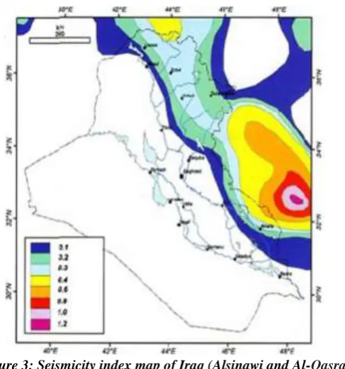
The seismicity index number (ST) which represents the frequency of occurrence of earthquake magnitude ML≥4, and according to Alsinawi and Al-Qasrani (2003) as shown in Figure (3), Baghdad is located in the region with 0.1≥ ST ≤0.2 where earthquake magnitude of M≥4 is probably to occur every 5-10 years within an area with a diameter of 100 km.
Figure 3: Seismicity index map of Iraq (Alsinawi and Al-Qasrani, 2003).
The parameter which describes loading at a site is the peak ground acceleration (PGA) which is widely used in earthquake and structural engineering. This parameter depends on the distance between site and the center of energy release and wave attenuation in soil.
Examining the seismic acceleration (peak ground acceleration PGA) of Iraq illustrated in Figure (4), it is clearly shown that regions E. Tigris River to Iraqi-Iranian Borders are with acceleration >0.2g (0.2-0.6g), and magnitudes ML≥4 (Ameer et al., 2005; Jassim and Goff, 2006); while lower acceleration (0.1-0.4g) is experienced for Mesopotamian area (region between Tigris and Euphrates Rivers) including Baghdad city (0.2-0.3g), and <0.3
15.02.2011 6:43:29 33.36 44.27 2.3 Al-Shuala
15.02.2011 6:43:38 33.29 44.33 2.5 Yarmouk
04.09.2011 1:26:01 33.38 44.08 2.9 Ibrahim Bin Ali
(near Abu-Ghraib)
29.11.2011 3:28:04 33.37 44.13 2.9 Ibrahim Bin Ali
(near Abu-Ghraib)
29.11.2011 8:41:38 33.47 44.32 3.5 Fahhama
05.02.2012 6:22:15 33.18 44.52 2.4 Mahmoodiya
18.09.2013 1:12:51 33.477 44.776 2.9 Iraq- Dyala
23.08.2014 6:16:29 33.038 44.88 3.3 N.E Suwayrah
[Karim* 4(5): May, 2017] ISSN 2349-4506
Impact Factor: 2.785
G
lobal
J
ournal of
E
ngineering
S
cience and
R
esearch
M
anagement
(0.1-0.3g) is recorded for W. Euphrates River and there is a chance of PGA to increase in the following several tenth years (Mahmood et al., 1988).According to many documented histories of Baghdad seismicity, the city has been subjected to many earthquakes in recent years listed in Table (2) (IMOS 2016). Examining the available data of the Seismological Bulletin published by the Iraqi IMOS for the last 5 years (2013-2017), a noticeable seismic activity is indicated particularly for November, 2013. In this year, 42 earthquakes hit northern, central, and southern parts of Iraq. Around 75% of these earthquakes occurred in Dyala- Khanaqin with magnitude (ML=4.6) on 24.11.2013. Other earthquakes occurred for the same year were with magnitudes ML>2-5 and depth <20 km reaching 60 km and rarely 100 km in few locations. These are as follows: 8 in April, 6 in May, 8 in June, 17 in July, 8 in August, 12 in September, 5 in November, 42 in November, and 12 in December 2013. It is worthy to mention that such earthquakes were displaced with time toward Iraqi territories.
From the seismological point of view and according to the above events, the seismic history of Baghdad reveals annual seismic activity of different strengths. Besides, Baghdad is surrounded by hazardous zones, as the nearest historical earthquake to Baghdad city had been occurred in 1508 and 1867 with magnitude values of 6.4 and 7 at epicentral distances (depths) 100 and 30 km respectively (Ambrassys and Melville, 1982).
Figure 4: Seismic acceleration map of Iraq with design period of 1oo years (Jassim and Goff, 2006).
DATA AND LOCATIONS
Baghdad was just a small village. The second Abbasid caliph Al-Mansour decided to build a new capital instead of
the second Abbasid capital in Al-Anbar (after Kofa). He chose the new site on the western bank of the Tigris River where the small village of Baghdad was already existed. Al-Mansour himself laid the foundation stone with great ceremony in 30 July 762 A.C. (145 Hijri). It took 4 years to be totally built and he called the city Madinat Al-Salam (City of Peace) and using the same ancient name (Baghdad). The city was circular in shape and about 2.4 km in diameter with double thick walls surrounding it and four equidistant great gates.
[Karim* 4(5): May, 2017] ISSN 2349-4506
Impact Factor: 2.785
[Karim* 4(5): May, 2017] ISSN 2349-4506
Impact Factor: 2.785
G
lobal
J
ournal of
E
ngineering
S
cience and
R
esearch
M
anagement
Figure 5: Site points location.
LIQUEFACTION POTENTIAL ANALYSIS
[Karim* 4(5): May, 2017] ISSN 2349-4506
Impact Factor: 2.785
G
lobal
J
ournal of
E
ngineering
S
cience and
R
esearch
M
anagement
on the most recent publications of the NCEER Workshop (1997) and SP117 Implementation (LiquefyPro Manual, 2015).The user can choose between several different methods for liquefaction evaluation. Using the SPT method with options that can be changed by the user. The options include earthquake magnitude and fines correction. Traditionally, a depth of 50 feet (about 15 m) has been used as depth of analysis for evaluation of liquefaction. Experience has shown that the 50-foot depth is adequate for most cases, but there may be situations where this depth is not sufficiently deep. The program can handle 1200 rows of data. If each row represents 1 inch of depth, you can input up to 100 feet (30 m) of data (LiquefyPro Manual, 2015).
With the assistance of this software, different earthquake magnitudes (4.0, 4.5, 5.0, 5.5, 6.0, and 6.5) were experienced. The user factor of safety (fs) was taken as 1.2 and 1.5 and two options of fines correction including Idriss and Seed (1997) and Modified Stark and Olsen (1995) options. Input data of the 200 points represent soil geotechnical properties at different depths such as the total borehole depth, the ground water level, standard penetration number (N), unit weight, and fines content. The peak ground acceleration (PGA) value was taken as 0.25g as an average for the range 0.2-0.3g of Baghdad as shown in Figure (4). More than 4800 runs in the program LiquefyPro were executed to analyze the data and get results with factor of safety at each 0.5 meter interval along the boreholes total depth.
RESULTS ANALYSIS AND DISCUSSION
Baghdad soil is of Holocene age (less than 10,000 years old) and the Tigris River flood sediments covered the area. The investigated data show that the fill layer in Baghdad ranges between 0.3-9.5 m (but sometimes 15-18 m which means as it is replaced the original subsoil strata) (NCCL, 1986; Hattab et al., 1986; Karim and Schanz, 2006). The fill layer is mostly made of ground and different mixed materials such as rubbish, debris, decomposed organic materials and crushed brick fragments. Although the water table ranges between (0.1-8.0) m, but mostly is less than 3.0 m below ground surface which means high water table (as noticed from the investigated data of the 630 boreholes). Also Baghdad city is covered with a shallow layer of clay (mostly mixed with silt and sand), but the depths below that are mostly loose to medium silty sand (Karim and Schanz, 2006).
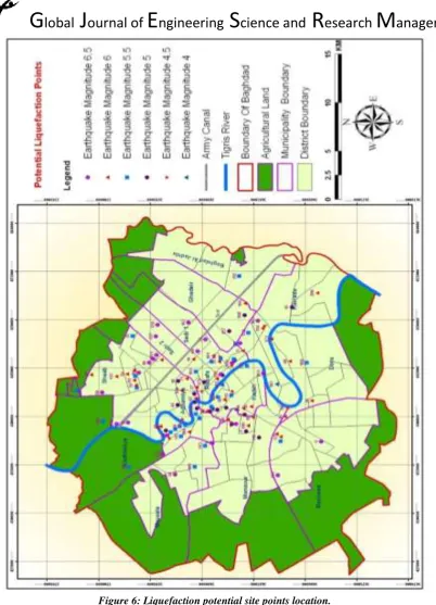
After the analyses of the 200 site points, only 121 site points seem to liquefy during earthquakes with different magnitudes (ML=4 to 6.5 with 0.5 interval). The results of each experienced earthquake magnitude will be stated individually. Due to the huge data and results obtained, the discussion of the susceptible points will be considered as groups. Thus, the output data are categorized into six groups. Table (3) presents a summary data for soil geotechnical properties of Baghdad for the six categories. While, Figure (6) illustrates the distribution of the liquefaction potential site points over the experienced earthquake magnitudes.
At earthquake magnitude ML=4, the analysis results show 4 sites (P5, P101, P107 and P145) that are susceptible to liquefy. Point P5 is susceptible to liquefy firstly at 12 m depth with 0.93 F.S (where 10% fines, 90% sand, only 6 SPT, 1.1m W.T, 0.4 m fill layer, and 19 kN/m3 unit weight). Point P101 shows susceptibility to liquefy firstly
at 4 m depth with 0.90 F.S (where 6% fines, 3 SPT, 2.0 m W.T, 4.5 m fill layer and 21.1 kN/m3 unit weight). Point
P107 shows susceptibility to liquefy firstly at 6.5 m depth with 0.84 F.S (where 6% fines content, 3 SPT value, 2.9 m W.T, 0.5 m fill layer, and 19.26 kN/m3 the unit weight. (It is worth to mention that this point is really
susceptible at depth from 6.5-9.0 m at this magnitude (ML= 4.0, but in this study only the first susceptible layer depth will be considered). The last point of this group is point P145 which shows susceptibility to liquefy firstly at 12.5 m depth with F.S. 0.88 (where 16 % fines, 84 % sand, only 2 SPT value, 2.35m W.T, 2.5 m fill layer, and 19.4 kN/m3 unit weight). The high percentage of loose saturated sand and the very low value of SPT tests number
observed in the strata of this site lead this point to be susceptible to liquefy.
At ML=4.5 earthquake magnitude, 9 sites show susceptibility to liquefy firstly at 3-13.5 m depth with 0.92-1.0 F.S, (where 3-93 % fines, 2-8 SPT values, 0.8-2.7 m W.T level, 18.5-20.5 kN/m3 unit weight, and 0.8-9.5m fill
[Karim* 4(5): May, 2017] ISSN 2349-4506
Impact Factor: 2.785
G
lobal
J
ournal of
E
ngineering
S
cience and
R
esearch
M
anagement
For group ML=5 earthquake magnitude, 19 site points are indicated. (It can be noticed from the data ranges shown in Table 3 that SPT is mostly less than 10 and although 5 of the points have fines more than 70% but the silt is more than 50% of these fines while 9 of the points have fines of 20% and less. The points P18, P78, and P129 are susceptible to liquefy at depths of 27, 25, and 24 m respectively, 10, 5, and 8% fines at these depths, and 18, 11, and 13 SPT values respectively. Point P18 has 53% sand and 37% gravel, while point P78 has 59 % sand and 36 % gravel, while the point P129 has 92% of sand only. So these high percentages of saturated granular layers with their low SPT values are within the consideration of liquefaction potential.
At earthquake magnitude ML=5.5, in this group 30 points show susceptibility to liquefy. Of these, 23 points at depth of 10 m and less, while 6 points at depth between 11-18 m and only point P144 shows at depth of 27.5m. Only 5 points have fines of 38-57% and 10 points with fines less than 20%. The rest of the fines percentage is of loose sand and sometimes with amount of gravel. For example point P123 at 14m depth has only 1% fines, 74% of poorly graded sand and 25% gravel. The other 15 points have fines 73-98 %, and 40-92 %. Silt is one of these fines, so these soils are clayey silts or silty clays but with amounts of 4-20 % sand and 2-10 % gravel. Silt is the largest fraction of these soils, so it leads to susceptibility of liquefaction of these points. The SPT values of this group are 2-17, and 24 of the 30 points (80%) have SPT value less than 10 while the rest 6 points have 12-17 SPT values.
Table 3: A summary data for soil geotechnical properties of Baghdad liquefaction potential sites.
Fill depth (m) W.T. depth (m) Fines (%) γt
(kN/m3)
[Karim* 4(5): May, 2017] ISSN 2349-4506
Impact Factor: 2.785
G
lobal
J
ournal of
E
ngineering
S
cience and
R
esearch
M
anagement
Figure 6: Liquefaction potential site points location.
[Karim* 4(5): May, 2017] ISSN 2349-4506
Impact Factor: 2.785
G
lobal
J
ournal of
E
ngineering
S
cience and
R
esearch
M
anagement
The last group is of earthquake magnitude ML=6.5, the number of points susceptible to liquefy in this group is 24 site points, where 19 points show susceptible to liquefaction at depth less than 10.5m, the rest points depth is less than 14.5m. The maximum SPT is 20 at point P50 at depth of 8m and fines are 8%, and 92% sand. The fines for 9 points are 18-55 %, while for 12 points the fines are 90-99 % for clayey silt and silty clay layers. Clay fraction for these points is 11-75 % while the silt fraction is 18-88 %. Two points P34 and P64 have 100% fines at 4.0 and 3.0 m susceptible depth, with 14 and 11 SPT value respectively. P34 has 2% clay and 98% silt (soft to medium of brown clayey silt) while P64 has 48% clay and 52% silt (stiff brown lean clay with little brick fragments). As mentioned before that the two sides of Baghdad: (Rusafa and Karkh), are divided into 97 districts (Hays) or neighborhoods. The 121 liquefaction potentially sites points are spread in only 59 of 97 districts (Hays) or neighborhoods. 33 sites (56%) in Rusafa side and 26 sites (44%) in the side of Karkh.From above discussion, it can be stated that in spite of Iraq is apparently safe from seismic hazards, but seismic observations indicate else. Earthquakes are likely to happen and may cause substantial damage, especially in NE Iraq and in the Mesopotamian Plain due to liquefaction of Quaternary sediments. It is therefore necessary to take into consideration seismic parameters in future design of large buildings.
CONCLUSIONS
The analysis of the data of hundreds soil investigation reports using LiquefyPro software,the results revealed the following conclusions:
1. Although Iraq is apparently safe from seismic hazards, but seismic observations indicate else. Earthquakes are likely to happen and may cause substantial damage. Thus, it is vital to take into account seismic parameters in future design of large buildings.
2. It is well noticed that Mesopotamian plain of recent sediments or thick fills of saturated cohesionless soils at shallow depths may be liquefied due to earthquake.
3. Among 200 study sites, the soils in 121 sites have the susceptibility to liquefy in different degrees, depending upon soil conditions, their geotechnical properties and seismic properties.
4. In 27 site points, the liquefaction potential layer is at 1.5 m within or below the fill layer itself.
5. Most of the susceptible sites are near or not so far from the Tigris River, some of them are relatively ancient bayous or areas were submerged by floods.
6. The SPT value is the most important indication to investigate the susceptibility more than the unit weight or the fines content percentages where the minimum and maximum SPT values were 2 and 23 respectively.
7. Not only the fine contents percentage affect the results, but also its nature must be taken in consideration such as silt which is very fine sand and exists in all Baghdad soil strata with different percentages. 8. Most of the high fines percentage in the susceptible sites (>80%) contain mainly silt fraction as a result
of sedimentations by Tigris River floods.
9. Regarding earthquake resistance, for a safe and economic design in the future, a proper estimation of liquefaction is required, also using any of many different mitigation methods such as vibro compaction, dynamic compaction, and vibro stone columns. While for already existing buildings, the injection of grout into the soil is recommended. These methods result in the densification of soil and enable buildings to withstand soil liquefaction.
REFERENCES
1. Albusoda, B.S., 2016, "Engineering assessment of liquefaction potential Baghdad soil under dynamic loading", Journal of Eng. & Development, Vol. 20, No. 1, pp. 59-76.
2. Al-Dabbagh, H.A., 1999, "Review and analyses of some earthquakes events in Iraq", M.Sc. thesis, University of Baghdad, 116 P., (In Arabic).
3. Ambrassys, N.N. and Melville, C.P., 1982, "A History of Persian earthquakes", Cambridge University Press.
[Karim* 4(5): May, 2017] ISSN 2349-4506
Impact Factor: 2.785
G
lobal
J
ournal of
E
ngineering
S
cience and
R
esearch
M
anagement
5. Alsinawi, S.A., 2001, "Seismological Considerations of the Eastern Arab Region", Proc.Euro-Mediterranean Seminar on Natural Environmental and Technological Disasters, Algers.
6. Alsinawi, S.A. and Al-Qasrani, Z.O., 2003, "Earthquake hazards consideration for Iraq", Proceedings Fourth International Conference of Earthquake Engineering and Seismology, Tehran, Iran.
7. Buringh, P., 1960, "Soils and Conditions in Iraq", Ministry of Agriculture, Baghdad, Iraq.
8. Ghalib, H.A.A., Aleqabi, G.I., Ali, B.S., Saleh, B.I., Mahmood, D.S., Gupta, I.N., Wagner, R.A., Shore, P.J., Mahmood, A., Abdullah, S., Shaswar, O.K., Ibrahim, F., Ali, B., Omar, L., Aziz, N.I., Ahmed, N.H., Ali, A. A., Taqi, A.K.A., and Khalaf, S.R., 2006, Seismic characteristics of northern Iraq and surrounding regions, in Proceedings of the 28th Seismic Research Review: Ground-Based Nuclear Explosion Monitoring Technologies, LA-UR-06-5471, Vol. 1, pp. 40–48.
9. Gritto, R. et al., 2008, "Crustal Structure of north Iraq from receiver function analysis", 2008 Monitoring Research Review: Ground-Based Nuclear Explosion Monitoring Technologies, Contract No. FA8718-07-C-0008, Proposal No. BAA07-59.
10. Hattab, T., Kachachi, J. and Taysir, S., 1986, "Study of the engineering soil characteristics in Baghdad area", 7th Iraqi Geological Congress, 1986.
11. IMOS; Iraqi Meteorological Organization and Seismology, 2016, Retrieved December 2, 2015, http://meteoseism.gov.iq/index.php?name=Pages&op=page&pid=168.
12. Jassim, S.Z., and Goff, J.C. (eds.), (2006), "Geology of Iraq", Dolin, Prague and Morravian Museum, Brno. 13. Johnson, P.R., (1998), "Tectonic map of Saudi Arabia and adjacent areas", Deputy Ministry for Mineral
Resources, USGS -TR-98-3, Saudi Arabia.
14. Karim, H.H. and Schanz, T., 2006, "A study of sediments homogeneity of Baghdad area with evaluating liquefaction potential and settlement", Iraqi Geol. J., Vol. 40, No. 1.
15. Karim, H.H., Fattah, M.Y. and Hasan, A.M., (2010), "Evaluation of some geotechnical properties and liquefaction potential from seismic parameters", Iraqi Journal of Civil Engineering, Vol. 6, No. 3, pp. 30-45.
16. Katzenbach, R., Clauss, F., Rochée, S., 2013, "Recent developments in procedures for estimation of liquefaction potential of soils", Proceedings of the 18th International Conference on Soil Mechanics and Geotechnical Engineering, Paris, 2013.
17. LiquefyPro Software Manual, 2015, Version 5 and later, CIVILTECH SOFTWARE, USA.
18. Mahmood, D.S., Yazia, K.A, and Jabbo, A.D., (1988), "Observation and analysis of Microtremor in Baghdad Metropolitian area", J. of Building Research, Vol. 7, No.2, pp.75-93.
19. NCCL: National Centre for Construction Laboratories, 1986, "A study of the engineering soil characteristics of Baghdad area", 82 P.
20. NCEER Workshop (1997), "Proceeding on Evaluation of Liquefaction Resistance of Soils", Nat. Ctr. for Earthquake Eng. Res., State Univ. of New York at Buffalo.
21. Prakash, S., and Puri, V.K., 2010, "Recent advances in Liquefaction of fine grained soils", Fifth International Conference on Recent Advances in Geotechnical Earthquake Engineering and Soil Dynamics on May 24-29.2010, San Diego, California, Paper No 4.17a.
22. Ramiah, B.K., and Ovanessian, R.A., 1982, "Engineering properties of sub-soils in Baghdad area", a report by the Building Research Center, Baghdad.
23. Seed, H.B. and Idriss, I.M., 1971, "Simplified procedure for evaluating soil liquefaction potential", J. Soil Mech. and Found. Division ASCE 97 (SM 9): pp.1249-1273.
24. Stark, T.D., and Olson, S.M., 1995, "Liquefaction resistance using CPT and field case histories", Journal of Geotechnical Engineering, ASCE: Vol. 121, No. 12, pp. 856-869.
25. Yi, F., (2010), "Procedure to evaluate liquefaction induced settlement based on shear wave velocity", Manuscript submitted to The 9th U.S. National and 10th Canadian Conference on Earthquake Engineering, Toronto, Canada, July 25-29, 2010.