A Review of the Status of Spatial Data Infrastructure
Implementation in Africa
Prestige Makanga
1, Dr. Julian Smit
2Geomatics Department, University of Cape Town, South Africa
ABSTRACT
Spatial data is a key resource for the development of a nation. There is a lot of economic potential that is locked away in spatial data collections and this potential is realised by making the data widely available. Spatial Data Infrastructures (SDI) provide a platform for spatial data users, producers and those that manage it, to distribute the data more efficiently. Governments all over the world are realising the value of National Spatial Data Infrastructures (NSDI), and therefore making major investments to establish them. However, in Africa, implementation of formal NSDI is being done at a seemingly slow pace. This paper presents an assessment of the status of NSDI activity in Africa. 29 countries were used in the survey and an assessment was made per region (South, West, East, North and Central Africa). The results show that generally, formal NSDI activity in most African countries is still in its infancy. The paper also gives recommendations of possible measures that can be taken to foster SDI implementation on the continent. In addition, it highlights potential areas for further SDI research.
KEYWORDS
Spatial Data Infrastructure, Geographic Information Systems, Implementation
1
Email: ptmakanga@gmail.com, 2
Julian.Smit@uct.ac.za
1.
INTRODUCTION
Spatial Data Infrastructures (SDI) are a key component in the development of a Nation. There is a lot of economic potential that is locked away in Spatial Data holdings and this potential is realised by making the data widely available through a SDI (UNECA, 2001). Spatial Data Infrastructures help facilitate access to and effective use of geospatial data for decision making applications. By April 2005, 83 countries worldwide had established National Spatial Data Infrastructure (NSDI) Clearinghouses on the internet [4]. This development indicates the large extent to which nations are prioritizing and formalising NSDI initiatives. In Africa, SDI are being implemented, although in some instances they are given a different name [13]. Evidently there is a lagging behind of formal NSDI activity in Africa, although there is a lot of informal activity that will contribute to the formal NSDI once governments are fully willing to participate in and take ownership of NSDI initiatives. Examples of organisations that informally contribute to NSDI development in Africa are the Food Aid Organisation’s Somalia Water and Land Information Management (FAO SWALIM) [18] and Southern African Development Community (SADC) Regional Remote Sensing Unit [9]. The clearinghouses for these organisations can be viewed at the following URLs:
http://geonetwork.faoswalim.org:8080/geonetwork/srv/en/m ain.home,
http://www.sadc.int/geonetwork
The FAO SWALIM portal facilitates access to spatial data for Somalia with the SADC portal does the same for countries
in the Southern African Development Community (SADC) region.
Although the above mentioned organisations are making critical contributions to SDI development, they do not have the legal mandate to officially sanction SDI activity and brand it with a formal national character. This is mainly due to the fact that these projects are run by Non Governmental Organisations (NGO’s) and have defined timelines for completion. There is therefore a high risk that once the projects have been terminated, most (if not all) of the effort will go to waste because of the potential failure to have well defined strategies to takeover and maintain the data at the local level. Von Hagen, [18] remarks;
“...while some SDI components appear to be in development, ultimately it is the handing over that is the critical aspect”.
For nations to derive the full benefit from the efforts of such projects there is need for a solid handover strategy. There should be structures in government that take an active part in the SDI initiative, which calls for formalising SDI initiatives and realising them as part of a broader national agenda.
(UNECA) have been contributing to SDI implementation on the continent. CODIST, among other organisations, has authored the Africa SDI handbook [15] which is a thorough guide for implementing SDIs. Unlike the INSPIRE directive [5] and the FGDC ([6]) that prescribe standards for SDI implementation, organisations like UNECA have mainly been doing awareness campaigns and have not prescribed any implementation policies. Therefore SDI activity on the continent is highly fragmented, with each country working independently. This means that there are no immediate drivers for SDI assessments at continental level in Africa, which is an indication that policy makers may not clearly understand the real benefits of SDI and the need for planning across national borders.
A number of countries have common access to natural resources for example Zimbabwe and Zambia share the Lake Kariba, and the water that is used in Gauteng (South Africa) flows from Lesotho. More informed hydrological analysis in this regard would at least require access to data at regional level. Regional SDI collaboration has been done before through the SDI East Africa initiative (http://www.ungiwg.org/sdi-ea/?q=about). This is being pioneered by the United Nations Food Aid Organisation (UN-FAO) because it appreciates the importance of SDI. However UN-FAO cannot really infiltrate political structures to influence government’s long term view on SDI collaboration and policy formulation across borders because the project is limited by defined timelines. The academic community is in an excellent position to carry out on going SDI research on the continent and to inform governments and other interested parties about prevalent SDI trends. African governments will potentially value the research output from the academia because they would assume impartiality. Research undertaken by the academic community is also not limited by project timelines in the way that NGOs like UN-FAO are.
The main purpose of this paper is to assess the status of formal NSDI development in Africa. It should be noted that this is different from the determination of Fundamental Geospatial Datasets for Africa project which was commissioned by Mapping Africa for Africa (MAFA) through the auspices of the Committee for Development Information's Subcommittee on Geo-information (CODI-Geo), a structure of the UN Economic Commission for Africa (UNECA) ([2]; Gyamfi-Aidoo et al, 2007). The MAFA project set out to determine the base datasets that are essential for each African country, and then went further to establish whether or not these datasets are actually available in different countries. The MAFA research did not explore other important issues like whether or not the available data is being shared and to what extent; it also did not quantify the amount of participation and collaboration in the data creation efforts, sharing and use. These are some of the areas that this research tries to address. The main question that this research seeks to answer is; 'to what extent have SDI been implemented in Africa?' The paper also serves as a platform to establish other areas of pending SDI research in Africa. A thorough review of informal thematic SDI activity on the continent is beyond the scope of this paper.
2.
A REVIEW OF SDI ASSESSMENTS
Since the late 1970s, many National Survey and Mapping organisations had begun to recognize the need to justify the large public investments they had received by improving access to and encouraging wider use of the spatial information in their custody [7]. The framework that was desired to achieve this need is similar to what we call SDI today. According to Grus et al [8], NSDIs are mainly established by government bodies and resourced by public funds hence the need to assess their
progress. The definition and purpose of an SDI varies from nation to nation. Some put emphasis on the creation of data, others on the sharing of available data and others on the use of prescribed standards. There is no prescriptive order in which the different components that make up an SDI should be implemented. Some implementing agencies choose to start with the clearinghouse, so as to present the concept to potential stakeholders in an attempt to sell the SDI concept. This portrays a seemingly advanced SDI status, but this can be an inaccurate portrayal considering that there are other viewpoints (described in the following section) that should be considered when assessing SDIs. Due to their complex, dynamic and evolutionary nature SDI assessments are difficult [8].
Hjelmager, et al. [11] proposed the use of the Reference Model for Open Distributed Processing (RM-ODP) for the design of an SDI. This model looks at the design process from 5 different viewpoints that are explained below and highlighted in figure 1:
Enterprise viewpoint: This viewpoint describes the purpose, scope and policies that are associated with the SDI. It describes the relationship between a system and its environment, its role and associated policies.
Information viewpoint: This describes the semantics of information and information processing incorporated into the SDI.
Computational viewpoint: A functional decomposition of the system into a set of services that interact through interfaces.
Engineering viewpoint: Contains the mechanisms and functions required to support distributed interaction between services and Data within the system. Its chief concerns are communication, computing systems and software processes.
Technology viewpoint: Contains the specific technologies chosen for implementation
emergent properties that cannot be understood by reference to the component parts [1].
A number of SDI assessments have been done before. The Multi-view SDI assessment framework is still being thought out. Crompvoets et al ([4]) proposes the use of different
methodologies that have sound theoretical backup and/or have been tested before to form the different component of the Multi-View assessment framework. This is summarized in table a below:
Table 1: Evaluation approaches proposed for the Multi-view framework ([8])
Approach Goal Description Method Status Assessment purpose class
Generational To measure the development of SDIs worldwide
Survey, document study Not developed Developmental
knowledge
Programme Evaluation
To determine worth and accomplishment of the objectives of SDIs
Case study and Survey Not developed Developmental
Knowledge Accountability
SDI Readiness
To assess if the country is ready to embrace SDI development
Survey Applicable Developmental
knowledge
Cadastral To measure 5 evaluation
areas of Land
Administration Systems
Survey Needs improvement Knowledge
Accountability
Organization al
To measure SDI
development from the institutional perspective
Case study Applicable Developmental
Performance based
To measure SDI
effectiveness, efficiency and reliability
Not available Needs improvement Accountability
Clearinghous e suitability
To measure the
development and impact of SDI clearinghouses worldwide
Survey, key informants Applicable Developmental
State of Play To measure the status of development of SDIs
Document study, survey, key informants
Applicable Developmental
Accountability
Pabon’s To measure the quality and virtue dimensions of SDI
Case studies, web survey Needs improvement Developmental knowledge
In the next 2 paragraphs the authors expand on the INSPIRE State of Play [17], which is in many ways similar to this assessment
The Infrastructure for Spatial Information in Europe (INSPIRE) directive was launched by the European Union in 2001. The purpose of this initiative is to contribute to the development of the European Spatial Data Infrastructure, building on existing NSDI initiatives. In 2002 the INSPIRE State of Play was launched in order to have a better view of the status of development of NSDIs in Europe.
The INSPIRE state of play is guided by a list of 30 indicators that have been used as yardsticks to measure the extent of SDI development throughout the whole of Europe [17]. These indicators have been grouped into four categories namely: Organisational, Funding, Legal and Technical. Data collection for the assessment is done through web searches, document surveys, telephone interviews and personal visits to relevant
people and organisations where possible. It was decided not to use a questionnaire for the assessment because “...the richness and variety of NSDI development could be captured better through a desktop study than doing this with a rather static survey” [17]. INSPIRE State of Play reports have been produced for the past 7 years and they have been able to quantify the amount of change that has occurred in the different NSDIs within Europe. This is also good for the purposes of learning SDI development trends, and informing implementation strategy changes.
3.
ADOPTED METHODOLOGY
INSPIRE State of Play, a questionnaire was created based on this final list of indicators. Many of the SDI activities in Africa are informal [13] and not normally branded as SDI and therefore it would have been difficult to find all the useful information through web searches. The questionnaire was sent to 269 people in 47 African countries. The authors did not manage to find suitable contacts in the 6 remaining African countries. The questionnaire was structured in such a way that allowed the respondents to add additional information about a specific indicator as well as any other information they necessary (see appendix A). This was done in an attempt to avoid the static nature of questionnaires, and in the process accommodate the diverse nature of SDI, and how different
people understand them. This resulted in the use of a more ethnographical approach to complement the static responses on the questionnaire.
Respondents were from various SDI coordinating agencies, National Mapping Agencies, NGOs, Universities and other key people in Africa. Through the questionnaire the authors managed to get input into this study which was not available on the internet. A document survey was also done to assess different NSDI activities. In instances where there was inadequate information from the questionnaire, documents, web visits and personal emails were sent to the relevant people to get the required information.
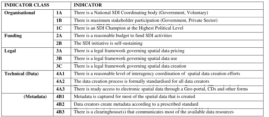
Table 2. SDI Assessment viewpoints and indicators
INDICATOR CLASS INDICATOR
Organisational 1A There is a National SDI Coordinating body (Government, Voluntary)
1B There is maximum stakeholder participation (Government, Private Sector) There is an SDI Champion at the highest political level
1C There is an SDI Champion at the Highest Political Level
Funding 2A There is a reasonable budget to fund SDI activities
2B The SDI initiative is self-sustaining
Legal 3A There is a legal framework governing spatial data pricing
3B There is a legal framework governing spatial data use There is a legal framework governing spatial data creation 3C There is a legal framework governing spatial data creation
Technical (Data) 4A1 There is a reasonable level of interagency coordination of spatial data creation efforts
4A2 The data creation process is formally standardised for all data creators
There is ready access to electronic spatial data through a Geo-portal, CDs and other forms 4A3 There is ready access to electronic spatial data through a Geo-portal, CDs and other forms
(Metadata) 4B1 Metadata is captured for most of the spatial data that is created
4B2 Data creators create metadata according to a prescribed standard
There is a clearinghouse(s) that communicates most of the available data resources 4B3 There is a clearinghouse(s) that communicates most of the available data resources
The Information was compiled to establish scores against the indicators. For all the indicators there were five possible responses namely; Absolutely True, Fairly True, Slightly False, Absolutely False and Not Sure. For the purposes of ranking, Not Sure =0, Absolutely False = 1, Slightly False = 2, Fairly True = 3 and Absolutely True = 4.
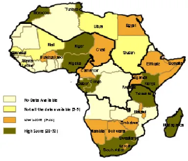
Responses were received from a total of 29 African countries for use in the study. Table 3 gives a summary of these countries and Figure 2 presents a map showing the spatial distribution of
Figure 2: Countries included in the Survey Figure 3: SDI Scores of the countries under study
4.
RESULTS
The results of the survey were tabulated into an assessment matrix of the indicators and the respective scores of each country in table 3. This concept was adopted from the INSPIRE State of Play.
The SDI score is a sum of the individual indicator scores for each country under study. In this study it is assumed that all the
indicators have equal weight and therefore a summation of the scores would give an indication of the relative status of SDI implementation, with regards to the given indicators. The scores were divided into three classes, one with low values due to missing data (2-5), and two other equal classes (5-28 and 28-53) and this is shown in Figure 3.
Table 3: Assessment Matrix
Region Country 1A 1B 1C 2A 2B 3A 3B 3C 4A1 4A2 4A3 4B1 4B2 4B3
SDI Score
South Botswana 4 3 2 3 1 1 1 1 2 2 2 2 2 1 27
West
Burkina
Faso 2 2 1 2 3 1 1 1 2 3 3 1 1 1 24
Central Cameroon 1 2 1 1 1 1 1 1 3 3 2 3 1 1 22
West Chad 3 1 3 1 2 1 1 1 1 1 3 2 1 4 25
West Congo 1 3 3 2 1 2 1 2 3 3 3 3 3 1 31
North Egypt 2 3 2 2 1 1 1 1 2 1 2 1 2 2 23
East Ethiopia 4 4 1 1 1 1 2 2 2 2 2 2 2 2 28
Central Gabon 4 4 4 4 4 1 4 4 4 3 4 4 4 4 52
East Kenya 4 3 3 1 1 3 3 2 1 2 2 2 2 4 33
South Lesotho 3 4 1 1 1 1 1 1 1 1 1 1 1 1 19
North Libya 4 0 0 0 0 0 0 0 0 0 0 0 0 0 4
South
Madagasc
ar 2 3 1 2 3 3 3 3 1 2 3 3 3 2 34
South Malawi 4 3 1 1 2 1 1 1 3 1 3 2 1 1 25
West Mali 4 0 0 0 0 0 0 0 0 0 0 0 0 0 4
North Morocco 4 4 1 1 1 4 4 4 4 3 1 2 1 1 35
South Namibia 2 2 1 2 1 1 2 1 1 1 3 3 2 1 23
West Niger 4 3 4 2 3 4 3 4 3 4 4 4 3 3 48
West Nigeria 4 4 4 4 3 4 4 4 2 2 1 2 2 2 42
East Rwanda 2 4 4 4 1 2 2 2 4 3 4 4 4 3 43
West Senegal 3 0 0 0 0 0 0 0 1 0 0 0 0 1 5
West
Sierra
Leone 4 0 0 0 0 0 0 0 0 0 0 0 0 0 4
East Somalia 1 1 1 3 1 1 1 1 2 2 3 3 2 1 23
South
South
Africa 4 3 3 2 2 3 4 2 1 3 2 1 2 1 33
North Sudan 2 0 0 0 0 0 0 0 0 0 0 0 0 0 2
South Swaziland 4 3 3 3 2 2 2 2 3 2 1 2 2 1 32
South Tanzania 4 2 3 3 2 3 3 2 3 2 2 2 3 2 36
North Tunisia 4 3 3 2 2 3 4 2 1 3 2 1 2 1 33
East Uganda 3 3 3 1 1 2 1 1 3 1 3 2 1 1 26
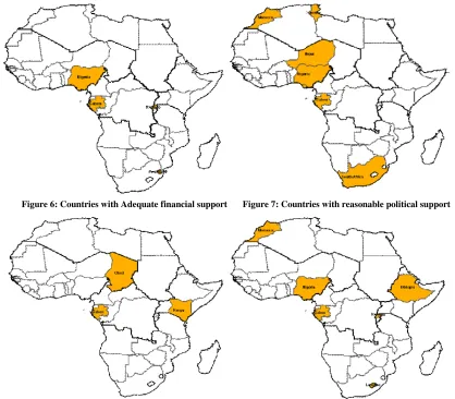
From Table 3, 20 out of the 29 countries at least have a body that is coordinating the attempts to come up with a formal SDI. Generally, there is minimal political support for NSDI initiatives. Rwanda and Uganda however, are among the countries that have a very high level of political support directly from the President’s office. For Rwanda this has been a major milestone and the country has managed to get adequate funding for its NSDI initiative. Only three other countries have expressed adequacy of funding for their NSDI initiative (Gabon, Swaziland and Nigeria).
The participation of stakeholders in NSDI initiatives is generally not satisfactory. Only 6 out of the 29 countries expressed satisfaction in the participation of different stakeholders in the NSDI initiatives. From the questionnaire there is a general lack of appreciation of the benefits of a NSDI to those that will potentially benefit and therefore there is no satisfactory participation.
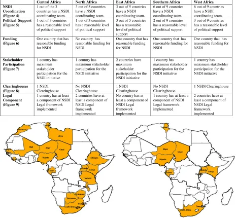
Table 4: Summary of Assessment results
Figure 4: Countries with NSDI coordination bodies Figure 5: Countries with a legal framework in place
Central Africa North Africa East Africa Southern Africa West Africa
NSDI Coordination (Figure 4)
1 out of the 3 countries has a NSDI coordinating team.
3 out of 5 countries have a NSDI coordinating team.
3 out of 5 countries have a NSDI coordinating team.
6 out of 9 countries have a NSDI coordinating team.
6 out of 9 countries have a NSDI coordinating team. Political Support
(Figure 5)
1 out of 3 countries has a reasonable level of political support
1 out of 3 countries has a reasonable level of political support
3 out of 5 countries has a reasonable level of political support
2 out of 9 countries has a reasonable level of political support
3 out of 9 countries has a reasonable level of political support
Funding (Figure 6)
One country that has reasonable funding for NSDI
No country has reasonable funding for NSDI
One country that has reasonable funding for NSDI
One country that has reasonable funding for NSDI
One country that has reasonable funding for NSDI
Stakeholder Participation (Figure 7)
1 country has maximum stakeholder participation for the NSDI initiative
1 country has maximum stakeholder participation for the NSDI initiative
2 countries have maximum stakeholder participation for the NSDI initiative
1 country has maximum stakeholder participation for the NSDI initiative
1 country has maximum stakeholder participation for the NSDI initiative Clearinghouses (Figure 8) 1 NSDI Clearinghouse No NSDI Clearinghouse 1 NSDI Clearinghouse No NSDI Clearinghouse
1 NSDI Clearinghouse
Legal Component (Figure 9)
1 country has at least a component of NSDI Legal framework implemented
2 countries have at least a component of NSDI Legal framework implemented
No country has at least a component of NSDI Legal framework implemented
1 country has at least a component of NSDI Legal framework implemented
Figure 6: Countries with Adequate financial support Figure 7: Countries with reasonable political support
Figure 8: Countries with NSDI Clearinghouses Figure 9: Countries with reasonable stakeholder participation
At the time of conducting this research, Kenya and Chad are the only countries with operational NSDI Clearinghouses. Although there are some other NGO initiatives that have created clearinghouses and geo-portals for data discovery and download, they are mainly for the datasets that are specific to particular projects. The two organisations that were mentioned in the introduction (SADC and FAO SWALIM) are examples of such initiatives. They are maintaining spatial data and metadata for the SADC region and Somalia respectively. These repositories are in no way exhaustive of all the data that is available in these areas. There still remains a lot of data in disparate unknown locations that needs to be communicated through NSDI clearinghouses.
Six countries have implemented at least a component of the legal framework. Most countries are still in the process of advocating for a legal framework to be put in place through their NSDI coordinating bodies. Some countries have acts pertaining to spatial data creation that were created in line with survey standards and these can contribute to the new legal frameworks for NSDI.
5.
CONCLUSIONS AND RECOMMENDATIONS
There is a clear need to speed up implementation of NSDIs in Africa. In 2003 there were 2 African countries that had
established NSDI clearinghouses ([3]) and 5 years later there are only 3. In fact at the time of writing, the two previously established clearinghouses had ceased to be operational. The following sections suggest some recommendations that can propel SDI implementation on the continent.
5.1
A bottom up approach
does not however mean that outreach efforts to Politicians must stop; the establishment of a formal NSDI needs a thorough legal framework and this requires high government support.
5.2
Handover Strategy
There is also a need for plans on how to handover current projects that contribute to the NSDI to governments so that the efforts do not go to waste when a project comes to completion. This may involve “teaming up” with government, even at low levels, so that they are aware of the SDI initiatives are happening.
5.3
Role of Free and Open Source Software for GIS
Free and Open Source Software for GIS (FOSS4G) plays an important role in the overall development of SDI in Africa. It does not generally involve a charge for field support unlike with proprietary software [12]. This should appeal to most African countries where there is minimal funding in support for SDI initiatives. Human resources capable of making a difference for SDI activities in Africa are a major challenge [2]. With FOSS4G, there is diverse technical support and documentation from previous experiences. Diverse technical environments and comprehensive user demands require using several different products in implementing GIS systems for distributed applications, such as SDI. Among these, the open source software products offer a viable and attractive alternative to the commercial solutions for such systems [14].
5.4
Areas of further research
This research has identified areas that need research for the future of SDIs in Africa; these are:
• Quantifying informal SDI activity
• Funding models for SDI in an African context
• How to make SDI development sustainable projects
• Models for handing over informal SDI activity to governments
ACKNOWLEDGEMENTS
The Authors would like to acknowledge SDI-Africa, a GSDI newsletter which was the main source for most of the documents used in this assessment and all the people that managed to create time to fill in the questionnaire that was used in this study.
REFERENCES
[1] Barnes, M., Matka, E. & Sullivan, H. (2003). Evidence, Understanding and Complexity: Evaluation in Non-linear Systems. SAGE Publications Vol 9(3) , 265–284. [2] Clarke, D. G. (2008). STATUS OF GIS IN AFRICA. GIS
Development .
[3] Crompvoets, J. & Bregt, A. (2003). World Status of National Spatial Data Clearinghouses. Journal of the Urban and Regional Information Systems Association Vol 15 , 43-50.
[4] Crompvoets, J., Bregt, A., Wachowicz, M., Jan Hofstede, G., Vereijken, P. & De Man, E. (2008). Exploring worldwide the impact of society on the success of national spatial data clearinghouses. Tenth International Conference for Spatial Data Infrastructure (GSDI-10), (pp. 1-19). Trinidad.
[5] European Parliament. (2007). DIRECTIVE 2007/2/EC OF THE EUROPEAN PARLIAMENT AND OF THE COUNCIL of 14 March 2007 establishing an Infrastructure for Spatial Information in the European Community (INSPIRE).
[6] FGDC. (1998). FGDC Policy on Access to Public Information and the Protection of Personal Information Privacy in Federal Geospatial Databases. Federal
Geographic Data Committee
(http://www.fgdc.gov/policyandplanning/privacypolicy.pd f).
[7] Groot, R. (1997). Spatial data infrastructure (SDI) for sustainable land management. ITC Journal 1997 - 3/4 , 287 - 294.
[8] Grus, L., Crompvoets, J. & Bregt, A. K. (2007). Multi-view SDI Assessment Framework. International Journal of Spatial Data Infrastructures Research, Vol. 2 , 33-53.
[9] GSDI. (2004). Developing Spatial Data
Infrastructures:The SDI Cookbook.
[10] Hevner, A. R., March, S. T., Park, J. & Ram, S. (2004). Design Science in Information Systems Research.
Management Information Systems Quarterly , 1-49. [11] Hjelmager J, Moellering H, Cooper A, Delgado T,
Rajabifard A, Rapant P, Danko D, Huet M, Lauren D, Aalders H, Iwaniak A, Abad P, Düren U & Martynenko A. (2008). An initial formal model for spatial data infrastructures. International Journal of Geographical Information Science , 1295–1309.
[12] Lakhani, K. R. & von Hippel, E. (2003). How open source software works: “free” user-to-user assistance.
Research Policy 32 (Elsevier) , 923-943.
[13] Lance, k. (2003). Spatial Data Infrastructure in Africa .
GIS Development , 1-6.
[14] Paluszyński, W., Iwaniak, A., Śliwiński, A. & Kubik, T.
(2007). BUILDING SPATIAL DATA
INFRASTRUCTURE AT COUNTY LEVEL USING OPEN SOFTWARE. International Cartographic Conference. Moscow.
[15] UNECA. (2001b). SDI Africa: An Implementation Guide.
http://geoinfo.uneca.org/sdiafrica/default1.htm.
[16] UNECA. (2001a). The Future Orientation of Geoinformation Activities in Africa. In T. G. United Nations Economic Commission for Africa, SDI-Africa: An Implementation Guide (pp. 1-31 (Chapter 1)). Addis Ababa.
[17] Vanderbroucke, D., Janssen, K. & Orshoven, V. J. (2009). INSPIRE State of Play: Generic approach to assess the status if NSDIs. In J. Crompvoets, A. Rajabifard, B. Van Loenen, & D. T. Fernandez, A Multi-view framework to assess SDIs (pp. 145-172). Space for Geoinformation, Wageningen University and Centre for SDIs and Land Administration University of Melbourne.
[18] Von Hagen, C. (2007). Towards a Spatial Data Infrastructure for Somalia using Open Source standards.
Journal of Spatial Science .
![Table 1: Evaluation approaches proposed for the Multi-view framework ([8])](https://thumb-us.123doks.com/thumbv2/123dok_us/8883061.1820965/3.612.74.529.138.531/table-evaluation-approaches-proposed-multi-view-framework.webp)