THESIS OF PhD DISSERTATION
UNIVERSTY OF WEST-HUNGARY
Department of Agricultural Sciences, MosonmagyaróvárINSTITUTE OF AGRICULTURAL, FOOD AND ENVIRONMENTAL ENGINEERING
"A"Program leader "B" Program leader Prof. Dr. Katalin Debreczeni Prof. Dr. Tamás Kismányoky
(PhD) DSc (PhD) DSc Supervisor
Prof. Dr. Miklós Neményi (PhD) DSc
Casemaps of the Precision (Site-specific) Farming
Written by:ZSUZSANNA PECZE
Mosonmagyaróvár 2001
1. THE ANTECEDENTS OF THE RESEARCH, THE GOALS
In case of conventional agricultural production the decision making is based on field level units. The GPS (Global Positioning System) makes possible to record the accurate location of the infield variability of the soil properties and the yield. Our position is known in every moment thus there is an opportunity to operate with smaller management unit consequently. The infield variability of physical and chemical soil properties, soil fertility and the effect of pests can also be taken into account.
The GIS (Geographic Information System) created by computing background makes possible to generate complex view about our fields and to make valid agrotechnical decisions. By the decisions created this way it is possible to apply the treatments which are take into consideration the above mentioned variability. Using this technology it is possible to provide the optimal or near optimal nutrient and chemical amount and the proper cultivation for each part of the field. Consequently we can be able to save money and to prevent the environmental pollution caused by the leaching out of the nutrition and by the overuse of chemicals (Pecze et al., 2001).
In the present situation the aim is to enhance the thrift and the efficiency for being able to move forwards the establishment
of a production system which can fill for additional requirements just like environment protection, production of quality food etc. The demand of environment production and healthy food, the prevention of the fields as well as the reduction of the costs together with the rising of the effectiveness are the reason for the precision farming system getting more popular in the future.
To attain this technology there are several systems in the market, however at the present their reliability is poorly known by users and even by researchers in Hungary and abroad as well (Neményi et al., 2001). This kind of results are e.g. the determination and recording of the infield deviations in soil properties, which are can be the take-off of international research programmes. Results field experiments are also available mainly in connection with fertiliser distribution and about DGPS application for creation yield maps and soil nutrition-content maps.
My aim was to improve the accuracy of the site-specific yield measuring technique (correct yield-, moisture- and area measurement) to adapt it for practical (field) circumstances and to build up GIS based database just as the practical application of the economic and environment friendly nutrient replacement.
2. MATERIALS AND METHODS
2.1 Description of the experimental field and the circumstances
The experimental field is situated next to Ács (Komárom-Esztergom country), its topographical number is 0419/18-27, its area is 32.5 ha with carbonated meadow chernozem and carbonated chernozem soil properties and mainly with sandy loam and less sandy texture of the ploughed layer. The field shows variability in connection with relief as well, there is a 10m of level difference.
The investigations were carried out in 1999 and 2000. The examined plant was maize (Dekalb 443 and Dekalb 391 hybrids). The showing dates were 23 April 1999 and 20-21 April 2000, respectively. The applied plant number is 60000, the fertiliser is ammonium-nitrate (34%).
The harvest took part in 26-27 October 1999 and 9-13 October 2000, respectively.
2.2 The site-specific yield mapping system and its review
The harvest was done by a Claas Mega 204 combine harvester equipped with RDS yield monitoring system.
The software and hardware components of the RDS system: - Jupiter GPS receiver, antenna
- Hermes data logger
- Ceres-2 board computer
- Ceres-2 yield meter
- Inclination angle sensor
- Speedometer
- Moisture sensor
- Cutting width sensor
- Personal computer
- RDS PF software
Before the beginning of the harvest the following settings have to be done:
- Sign out the crop
- Tare setting, probe harvesting,
control the hl-weight and moisture content, comparing the deviation between the monitored and the control weight value just as set the new calibration factor
- Set the hl-weight
- Set the moisture content
The data are recorded into the floppy disc placed in the Hermes data logger and can be processed by the RDS PF software.
2.3 The soil sampling method
During the experiments the ACT board computer of the Agrocom system were used for soil sampling.
-In 1999 grid-sampling method was applied. Each
sampling unit was 100x100 m where average samples were taken.
-In 2000 the sample points were sign out in the basis of the yield map from 1999.
After that, knowing the position of the sample points I created the sampling plan by the AGRO-MAP Basic software and I exported it to the PCMCIA card. Sampling tube were applied for the sampling in 25 cm depth in 9-10 March 2000.
2.4 The applied soil survey methods
The following analysis were carried out at the Central Laboratory of the University of West-Hungary, Department of Agricultural Sciences (Mosonmagyaróvár):
Determination the upper limit of plasticity (KA), determination of the pH value by direct potentiometry in 1:2.5 nKCl suspension, colorimetric humus content measurement, determination of calcium-carbonate content by Scheibler method, Al-solvable phosphorus and potassium content measurement, determination of magnesium content from nKCl soil extract, Mn, Zn, Cu, Fe content determination from
EDTA soil extract, B(hot water) measurement with ICP, total salt amount determination from soil pasta by conductance.
2.5 Methods of statistic analysis
I defined the correlation matrix describe the connections among the given soil properties, and among the soil properties and the height values by linear regression calculation.
The connection among the yield categories of 1999 and 2000 were decided, the soil properties or rather the height values by oneway analysis of variance. This method allows applying different repetition numbers.
2.6 The applied fertiliser advisory system
I applied the environmental friendly fertiliser advisory system developed by the Research Institute for Soil Science and Agricultural Chemistry of the Hungarian Academy of Science and the Agricultural Research Institute of the Hungarian Academy of Science (Martonvásár). This advisory system is based on the data set of the Hungarian long-term field trials and - corresponding to the nowadays' requirements - takes into account the point of views of environment protection and economy (Csathó et al., 1998).
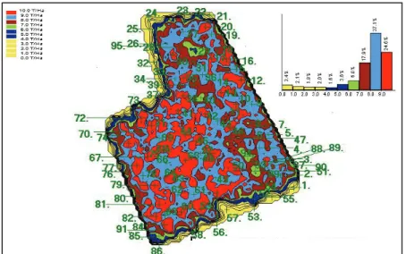
Figure 1. Yield map of maize with sample points (1999, Ács, 0419/18-27topographic number)
2.7 The applied fertiliser advisory system
For the creation of yield maps I applied the RDS PF software. For the generation of soil sampling plan and fertiliser application map the AGRO-MAP Basic v.3.0 were used. The data transport was done by floppy disc in case of RDS system and by PCIMCIA card in case of Agrocom system. The data of the sampling points and the results of the analysis were exported into the AGRO-MAP Basic v.0.3. The data of the polygons representing the soil sample units as well as the attributum data in connection with those units were exported to the MapInfo Professional v.0.6 and the soil nutrition-content map and the advised fertiliser plan were created.
For the building up of the relief model of the field I used the co-ordinate data of the RDS PF data basis origin from the harvest and the MapInfo Vertical Mapper software.
I collected the followings in connection with the examined area:
1. 1:10000 genetic soil map with the lab data and
explanation text (source: Agrorum Ltd., Ács)
2. 1:10000 land use map (source: Region Land
Office, Komárom) 1:4000 land use map
3. 1:4000 black and white airborne picture, 1:10000
black and white airborne picture and the digitised form of it (source: Institute of Geodesy, Cartography and Remote sensing, Budapest Archives)
4. 1:10000 scanned, digitised topographic map (No.
73-441 sections)(source: Institute of Geodesy, Cartography and Remote sensing, Budapest)
For the building up of the uniform GIS the ArcView based AGRO-MAP Professional software was chosen.
2.8 Description and operation of the fertiliser distributor system
Next to the positioning system (DGPS) a machine is also required which is able to realise the special spreading
in the fertiliser spreader together with the proper software which is able to accept the signs sent by the board computer (ACT) through the central communication unit (LBS).
The information from the board computer and the fertiliser distributor machine as well as from the sensors (speedometer, TLT rev) mounted in the tractor. The AMAZONE ZA-M MAX Tronic fertiliser spreader in which an electronic sleeve-valve controls the applied amount fulfis for these requirements. Therefore this kind of spreader was used.
Before the beginning of the spreading some setting has to be done:
-The impulse number per 100 meters (SMGR
software),
-The impulse number per wheel revolution (SMGR
software),
-And the system must to be calibrated (ZUG_AM). During the calibration the amount of the fertiliser released in a given time should be measured. The calibration factor determined by the Job computer of the spreader must be between 0.7 and 1. If it is out of this interval the calibration must be repeated. This procedure demands half a minute. After that the data of the fertiliser application map transferred into the ACT by a PCMCIA card and the fertiliser application can be ordered by means of the proper software. In the distributor software menu the required settings must be done and than the spreading can be started. During that the
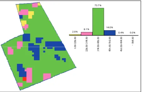
ZUG_AM is monitoring the picture of the field, the working speed, the TLT rpm and the amount of fertiliser in the hopper. The user is warned by the system if the GPS or DGPS signal stops out, if the data in the chip card is erroneous or if the TLT rpm is false set as well as if loading is required. The system distributes the programmed amount of fertiliser independently on the speed and TLT rpm (in given rpm interval). The TLT rpm is continually measured. It is marked by the system if the rpm is over the given interval. The distributed fertiliser amount also continually counted. I created the fertiliser application plan using the data given by the advisory system by the AGRO-MAP Basic v.3.0 (figure 2.). Ammonium-nitrate 34% was applied in the experiment field.
(ammonium-3. CONCLUSIONS, NEW SCIENTIFIC RESULTS
1. I determined by examinations and measurements that the infield variability must be examined more accurate (more detailed) than the present practice with the average soil sample of 6-12 has.
2. I determined by examinations that the yield map based soil-sampling method proved to be correct.
3. By the examination of the soil properties I determined that in spite of the infield variability there is a positive significant correspondence between the soil constraint and the humus content.
4. Comparing the 2 years' yield maps I determined that infield yield variability can be effected by site-specific nutrition replacement and consequently the "yield map" can be modified as it is required.
5. By the examination of the combine harvester and the system I determined the followings:
- The time is required for the crop passing
trough the harvester can be set only with rough accuracy,
- In case of strong weed infection there was
the monitor. I could observe correct values only after 2-3 minutes later what can leads to distortion,
- After the beginning of the harvest 0% of
moisture content than unreal low values were displayed for 10 s and only after 22-25 s of slow rising was the real value shown. By this time the harvester can finish the short rows. In this case correction must be done by the board computer, but in short harvesting routs there can be too much correction.
6. By the examination of the nutrition distributor system I declare the followings:
- The grid which can be laid on the map of
the field can not be turned during the creation of fertiliser application plan therefore, it is impossible to make parallel the grid's line with the borderlines thus, the fitting is not perfect in case of Agrocom system,
- In the fertiliser application plan only
discrete values can be given: interpolation is not possible. Therefore sudden changes occur between the subsequent doses,
- The ACT unit mounted in the cab of the tractor showed the position of the machine during fertiliser application but did not provide directional guidance in spite of the fact that the working width was pre-programmed,
- It further caused problems that the ACT
does not show the already distributed fertiliser strip in the field. This increases the chance of fertilising the same spot twice as well as making accurate overlapping difficult.
7. After the examination of the geographic information system I lay down the followings:
- Yield maps created by the RDS system
cannot be converted in the Agrocom system, because RDS uses a special file type. This shows the lack of standardization between the chosen systems, which makes difficult to use and increase the costs. This contradicts to the basic idea of the precision farming.
- In case of RDS PF software it is impossible to cut and handle separated the given parts of a field.
4. SUMMARY
The dissertation provides new information about the casemaps of the precision (site-specific) plant production.
My aims were to improve the accuracy of the site-specific yield measuring technology (correct yield-, moisture content- and area measurement) and the adaptation of the system for the practical conditions. I intended to build up a GIS based database and to bring to effect the economic and environmental save nutrition replacement under practical circumstances.
The RDS system was used for yield measuring and mapping, the Agrocom and the ACT/AMAZONE system was applied for area identification, soil sampling and fertilizer distribution, whereas the GIS had been built up by means of AGRO-Map Professional and MapInfo professional software.
Grid sampling method (1999) and yield map based soil sampling method (2000) were applied in the experimental field in Komárom-Esztergom country.
During the creation of the fertilizer distribution plan the MTA-TAKI MTA MGKI environment friendly advisory system's recommendations were taken into consideration using the soil analysis results and the field register book's preceding data. It can be declared with full knowledge of the research results that the infield variability of the soil fertility determinative
factors makes reasonable the way of nutrition replacement, which take into account the local conditions. I found by biometrical analysis that the soil properties of 2000 show strong correspondence with the yield of 1999, consequently it is verified, that the yield can reflect the soil fertility. Thus, the principle of yield map based soil sampling has proved to be correct.
Comparing the two years' yield maps with each other I determined, that the infield variability of the yield has decreased, whereas using the same amount of fertilizer the yield has increased comparing with the homogenous fertilizer application.
The area measurement and the positioning with the RDS system can be declared to be accurate. During the fertilizer distribution, the ACT unit signed the position of the tractor, but could not show the required heading nevertheless the working width should have been set before the job started. Therefore sticks were required to be mounted in each 18 meter to indicate the working strips, however it was not only wasting time, but it was difficult because of the micro-relief. Knowing the position of the tractor, the field and the working width, all information is given to sign the spreading strips on the monitor of the ACT. It is necessary to solve this problem. The main aim during the building up of the GIS is to make compatible the export/import surfaces so to enable the
communication between database origin from different sources.
5. REFERENCES
1. Csathó,P.- Árendás,T.- Németh,T.:1998: New, environmentally friendly fertiliser advisory system, based on the data of the Hungarian long- term field trials set up between 1960 and 1995. Communications in Soil Science and Plant Analysis. 29. 2149-2160.
2. Neményi, M.- Pecze, Zs.- Stépán, Zs.- Kacz, K.- Szaxon, A.: 2001 A precíziós növénytermesztés műszaki tapasztalatai Magyar Tudományos Akadémia
Agrár-Műszaki Bizottság XXV. Kutatási És Fejlesztési
Tanácskozás. in print
3. Pecze,Zs. - Neményi,M. - Mesterházi,P.Á.: 2001 A
helyspecifikus tápanyagvisszapótlás műszaki háttere.
6. PUBLICATIONS
6.1. Journal, Articles
1. Kalmár S. -Pecze Zs. (2000): Hozamtérkép készítése AGRO-MAP 3.0 programmal. Növényvédelmi Tanácsok 09. (01.) 16-18.
2. Mesterházi, P.Á.- Pecze,Zs.- Neményi, M. (2001): A
precíziós növényvédelmi eljárások műszaki -
térinformatikai feltételrendszere. Növényvédelem in print 3. Neményi M. -Pecze Zs.- Stépán Zs.-Kacz K.-Szaxon A.
(2001): A precíziós növénytermesztés műszaki
tapasztalatai. Magyar Tudományos Akadémia
Agrár-Műszaki Bizottság XXV. Kutatási És Fejlesztési
Tanácskozás. in print
4. Neményi, M.- Pecze, Zs.- Mesterházi, P.Á.- Kiss,E. (2001): Engineering environment of the precision crop production Hungarian Agricultural Engineering. in print 5. Neményi M. -Pecze Zs. (1999): A műholdas
helyzetmeghatározás szerepe a mezőgazdasági folyamatok
irányításában. Moson Megyei Műhely. Mosonmagyaróvár.
02. (02.) 115-123.
6. Pecze,Zs. - Neményi,M. - Mesterházi,P.Á. (2001): A
helyspecifikus tápanyagvisszapótlás műszaki háttere.
Mezőgazdasági Technika. .42, 02:5-6.
7. Pecze Zs.- Neményi M.- Mesterházi P.Á.- Stépán Zs., NYME- Kiss E., IKR Rt. Bábolna (2001): Termés- és talajadatokra alapozott helyspecifikus műtrágya-kijuttatás.
Magyar Tudományos Akadémia Agrár-Műszaki Bizottság
8. Pecze Zs. -Kalmár S. (1999): Termőhelyspecifikus gazdálkodás a gyakorlatban. Növényvédelmi Tanácsok 08. (12.) 13-15.
9. Pecze Zs. (1998): Termőhelyspecifikus mezőgazdaság (precíziós gazdálkodás). Növényvédelmi Tanácsok. Mosonmagyaróvár. 07. (5.) 37-40.
10.Pecze Zs. (1998): Részterületspecifikus növénytermesztés különös tekintettel a trágyázásra IV Ifjúsági Tudományos Fórum kiadványa, Keszthely, 03. 19. 145-149.
6.2. Papers on conferences and workshops
1. Neményi M.- Pecze Zs.- Kovács A. J. (2001): A precíziós mezőgazdaság műszaki feltételrendszerének fejlesztése "Lippay János - Vas Károly" Tudományos Ülésszak, Budapest, Szent István Egyetem, 2000. 09. 06-07
2. Neményi M. - Pecze Zs. - Stépán Zs.- Kacz K. - Szaxon A. (2001): A precíziós növénytermesztés műszaki tapasztalatai Magyar Tudományos Akadémia
Agrár-Műszaki Bizottság, XXIV. Kutatási és Fejlesztési
Tanácskozás, Gödöllő, 2001. 01. 23-24.
3. Neményi M.-. Kovács A.J.-Pecze Zs. NYME, Kiss Istvánné IKR Rt. (2000): Helyspecifikus (DGPS) kijuttatásra alkalmas műtrágyaszóró rendszer üzemeltetési tapasztalatai (OMFB), Magyar Tudományos Akadémia
Agrár-Műszaki Bizottság XXIV. Kutatási és Fejlesztési
Tanácskozás, Gödöllő, 2000. 01. 18-19.
4. Neményi M.-Pecze Zs.-Petróczki F.- Gergely S. (1999): Hozamtérképek helyspecifikus felvételének műszaki hátter
(GPS). Magyar Tudományos Akadémia Agrár-Műszaki
Bizottság XIII. Kutatási és Fejlesztési Tanácskozás, Gödöllő 1999. 01. 19-20.
5. Neményi M. -Pecze Zs.- Petróczki F. (1998):
Agrárműszaki feladatok a térinformatikai adatbázis
felvételénél illetve annak bővítésénél. VII. Térinformatika a felsőoktatásban szimpózium, Budapest KEE 1998. 10.21. 6. Pecze Zs.- Neményi M.- Mesterházi P.Á.- Stépán Zs.,
NYME- Kiss E., IKR Rt. (2001): Termés- és talajadatokra
alapozott helyspecifikus műtrágya-kijuttatás. Magyar
Tudományos Akadémia Agrár-Műszaki Bizottság, XXIV.
Kutatási és Fejlesztési Tanácskozás, Gödöllő, 2001. 01. 23-24.
7. Zs. Pecze- M. Neményi - E. Kiss - F. Petróczki (1999): Investigation of the accuracy of the RDS Yield mapping system. 2nd European Conference on Precision Agriculture. Odense, Denmark. 11-15. July.
8. Pecze Zs. (1998): Részterületspecifikus növénytermesztés különös tekintettel a trágyázásra. IV. IFJUSÁGI FÓRUM. Keszthely. 1998. Március 19.