A H
IgHS
IerrAnn
exuS:
H
oto
BSIdIAnd
AtAFromd
onnerm
emorIAlS
tAteP
Arkwilliam bloomerand denise Jaffke
Recent archaeological excavations at CA-NEV-13/H in Donner Memorial State Park were conducted for research and management. Although this site is listed on the National Register for its association with the Donner Party, recent prehistoric investigations show the Donner site also was a primary nexus for California and Great Basin interaction. Importantly, obsidian studies data point to a distinctive Early Archaic link to northeastern California and northwestern Nevada that is not represented at other major sites in the Tahoe Sierra.
R
esearchers have contended for years with the general scarcity of the prehistoric record before 4,000 years ago in the Tahoe Sierra region (Figure 1). While archaeological evidence suggests that pre-Archaic populations were present in the Tahoe Sierra by about 10,000 years ago, it is curious that prehistoric chronological data gathered from the region rarely predate the Middle Archaic, before 4,000 years ago. This situation is changing with new obsidian data from CA-NEV-13/H in Donner Memorial State Park. In this presentation we focus on the Early Archaic adaptive period in Tahoe Sierra prehistory, which generally coincides with the Middle Holocene Climatic Period (Table 1).Interpretation of geochemical sourcing and hydration data from NEV-13/H provides the basis for a discussion of the movement of obsidian through the High Sierran Truckee corridor from sources as far distant as the North Coast Ranges, east-central California, northwestern Nevada, and northeastern California - forming what we’re referring to as
The Obsidian Triangle (Figure 2), with Donner serving as a nexus. In this paper, we present these findings in relation to regional patterns and propose the relevance for Early Archaic studies in the Tahoe Sierra.
Three recent investigations at NEV-13/H in Donner Memorial State Park have generated an obsidian hydration and XRF database that gives us a distinct Early Archaic land-use signature that is, to date, unique in Tahoe Sierran archaeology.
Ca-nev-13/h s
iteh
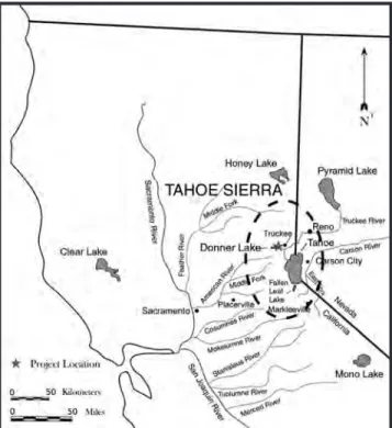
istoryMulticomponent site NEV-13/H is a very expansive, complex archaeological site situated on a large, flat terrace on both the north and south sides of Donner Creek, just east of Donner Lake within a complex of Tioga moraines. The site covers an area of approximately 60 acres. The historic component includes seven historic debris concentrations with at least 19 features dating from 1844 and consists of several trash dumps, the Pioneer Monument, the Murphy Cabin site, remains of the Towle Mill, blacksmith shop remains, telegraph features, a historic dam, and a bridge. The prehistoric component of NEV-13/H consists of at least four dense loci with diagnostic artifacts, milling equipment, and hearth features. The site has been listed on the National Register of Historic Places (NRHP) since 1978 and is considered significant based on its association with the Donner Party tragedy. It is a difficult property to manage due its size and the collective impacts from historic-era and contemporary visitor use and park maintenance activities. Figure 1. The Tahoe Sierra Region.
William Bloomer, Lithic Arts, Woodfords, CA and Denise Jaffke, Department of Parks and Recreation, Sierra District, Tahoma, CA Proceedings of the Society for California Archaeology, Volume 21, 2009, pp. 109-115
Limited testing in 2004 (Jaffke 2005) and subsequent data recovery efforts in 2005 (Bloomer and Lindström 2006) in preparation for a Donner Dam retrofit project revealed intact prehistoric hearth features in dateable contexts, an unexpected and rare find in the region. This prompted concern regarding management and protection from the cumulative impacts suffered by various projects within the site. Subsurface investigations at NEV-13/H had previously been limited in scope and often focused on specific areas with particular research objectives. Due to personnel and funding constraints, the management strategy for this site has been to monitor and recover diagnostic artifacts, post-hoc. These
collections were often curated with minimal or no analysis or reporting. It has been difficult, if not entirely impossible, to properly assess the cumulative impact of various projects to the site as a whole, and most especially the prehistoric component, without understanding the data and research potential that this site has to offer.
To address this disparity, the Sierra District requested funds from the Department of Parks and Recreation’s Cultural Resources Division for the sole purpose of creating a database of information to help with evaluating whether future projects will adversely impact the resource. This research database was initiated by conducting an NRHP eligibility investigation (Nelson et al. 2007) across two of the richest prehistoric deposits within the NEV-13/H site boundary, at Locus F and Locus G.
The results of this test investigation proved invaluable not only for addressing project impacts, but also to provide important information regarding the prehistory of the region, most especially concerning our developing understanding of Early Archaic settlement patterns. Although three independent excavations have been conducted at NEV-13/H in recent years, the data produced from the Locus F and Locus G test investigation, conducted by Furlong Archaeological Consulting and Lithic Arts, provides the vast majority of the data discussed in this paper.
Figure 2. The Obsidian Triangle.
Table 1. The Tahoe Sierra Chronology
Climatic Period Adaptive Sequence* Years BP*
Late Holocene Late Archaic Period 1,300 Middle Archaic Period Middle Holocene Early Archaic Period 4,000 7,000 Early Holocene Pre-Archaic Period 10,000 Late Pleistocene Fluted Point Period > 13,000 * Based on Elston 1986; Elston et al. 1994
o
bsidians
tudiesConducting archaeological research in the Tahoe Sierra region is problematic, since deposits often lack stratigraphic integrity and associations with distinct temporal components. Organic preservation of charcoal for radiocarbon dating is rare, primarily associated with hearths floating in otherwise vertically bioturbated granitic sediments, and bone preservation is typically limited to calcined fragments. Additionally, diagnostic projectile point types are loosely based on morphological correlates from the Great Basin with poorly defined temporal ranges.
In the face of these limitations, we have turned our attention to the issues of Paleoclimate, Land-Use Adaptation, and Obsidian Studies. Obsidian Studies is the issue we are focusing on as hard data, in the contexts of climatic and land-use models.
Obsidian hydration studies are developing with increasing regularity as more and more Tahoe Sierra sites are investigated. Hydration data have recently become the primary temporal dataset for the chronological interpretation of archaeological deposits. In the Tahoe Sierra, obsidian hydration data are interpreted with reference to a hypothetical hydration curve (Figure 3). The curve is based on two anchor points, one at each end of the temporal spectrum. The older end of the curve is anchored by a 7.0 hydration mean from the Visitor Center Site (FS 05-19-795) in South Lake Tahoe (Martin 1998) - the only known subsurface single-component pre-Archaic deposit in the region. Pre-Archaic deposits typically predate 7000 B.P. Therefore, the 7.0 micron value is interpreted at greater than 7000 B.P. The younger end of the curve is anchored by the 2.5 micron value at 1300 B.P., because Late Archaic arrow point hydration data are relatively consistent at less than 2.5 microns.
Take note that this hydration curve will change with new data, but the curve does represent the general tendency for obsidian hydration above the 5,500 ft. elevation. The 5,500
ft. elevation is significant because at this high elevation the hydration rate is noticeably slower than at lower elevations along the western Sierran foothills. In addition, with chilling temperatures, periodic forest fires, and constant bioturbation of archaeological deposits, the hydration rate has likely varied.
Because of this variability, the current rate curve is applied to obsidian from all sources. Most obsidian sources vary in hydration rate - but only a few are extremely different. These extremely slow or fast sources are uncommon in the Tahoe Sierra database. Obsidian hydration studies in the Tahoe Sierra remain relative. Nevertheless, the rate curve anchor points are sound.
h
oto
bsidiand
atafromCa-nev-13/h -
C
omParisonwithr
egionals
itesThe obsidian dataset compiled during three investigations at NEV-13/H includes 74 hydration rim measurements (Figure 4), representing 79 percent of the available obsidian artifacts. Donner has a long history of prehistoric site use, beginning possibly around 10,000 years ago and continuing to Euro-American contact.
A full 50 percent of the rim values indicate that the most consistent site occupations occurred during the Early Archaic Period. This record of Early Archaic occupations is distinct in the Tahoe Sierra. No other investigated site shows such a high frequency of Early Archaic occupations. In fact, a more typical obsidian hydration data set for Tahoe Sierra sites reflects predominantly Middle Archaic occupations, or that sites were occupied during Middle Archaic and Late Archaic periods. Throughout the Tahoe Sierra, the regional chronology is dominated by Middle and Late Archaic land use represented by over 1,300 specimens from 52 sites (Figure 5), including the major excavations conducted in the past 30 years.
Figure 3. Hypothetical obsidian hydration rate curve for the Tahoe Sierra.
Figure 7. Pie charts comparing NEV-13/H obsidian source percentages for the Pre-Archaic and Early Archaic with Middle
Archaic and Late Archaic obsidian source percentages. Figure 5. Obsidian
hydration data bars for 52 Tahoe Sierran sites.
Figure 6. Pie chart of NEV-13/H obsidian source percentages (BS/PP/FM = Bordwell Spring/Pinto Peak/Fox Mountain).
Figure 4. Obsidian hydration data bars for NEV-13/H.
The predominance of Early Archaic occupations at NEV-13/H provides a unique temporal context for Tahoe Sierran obsidian studies. While obsidian hydration data give us the relative temporal period for patterned occupation at the site, our research and discussion focus on the geochemical sourcing data, with which we can begin to make inferences about regional land-use patterns and the significance of NEV-13/H.
The obsidian studies dataset compiled during the three investigations at NEV-13/H includes geochemical XRF source determinations for 61 artifacts representing 65 percent of the available obsidian artifacts. As many as 14 distinct obsidian sources are represented in the dataset (Figure 6). It is unusual that six (East Medicine Lake; Buck Mountain; Massacre Lake/Guano Valley; Buffalo Hills; Bordwell Spring/Pinto Peak/Fox Mountain [BS/PP/FM]; and South Warners) are from northeastern California and northwestern Nevada. Other Tahoe Sierran sites have one or two of these distant sources, but NEV-13/H has six. Also, three of the four North Coast Ranges sources (Napa Valley, Borax Lake, and Annadel) are represented. Added to that are five major Eastern California sources (Bodie Hills, Mt. Hicks, Sutro Springs, Casa Diablo, and Queen) that comprise the largest part of the dataset. Surprisingly, the typically dominant Bodie Hills source accounts for only 30 percent of the NEV-13/H sample.
Usually Bodie Hills accounts for well over 50 percent of any one site in the Tahoe Sierra (Markley and Day 1992). Contrasting obsidian source data from the predominantly Early Archaic NEV-13/H with source data from the large predominantly Middle Archaic Squaw Valley site complex (PLA-163, -164, -165, and -957) indicates the distinctive character of NEV-13/H obsidian. NEV-13/H has 14 sources with only 30 percent Bodie Hills, while Squaw Valley has nine sources with 60 percent Bodie Hills.
The unique character of NEV-13/H obsidian sources is a direct result of the prevalence of the earliest prehistoric deposits. The truth of this is shown by comparing source data for the pre-Archaic and Early Archaic obsidian with the source data for the Middle Archaic and Late Archaic obsidian (Figure 7). Both assemblages are represented by 10 sources, yet their characters are very different.
The Early assemblage is represented by more obsidian from the BS/PP/FM source group in northwestern Nevada than from the eastern California Bodie Hills source. What’s more, three distant obsidian sources from northwestern Nevada and northeastern California are present, which are not represented at all in the later assemblage. Also, Napa Valley obsidian is well represented in the early assemblage, but it is the only source of the North Coast Ranges obsidian group.
The late assemblage is dominated by Bodie Hills obsidian with more Mt. Hicks and less Sutro Springs obsidians. Moreover, there is no BS/PP/FM obsidian in the late assemblage, while northern obsidian procurement has decreased to only two sources (South Warners and Buffalo Hills). At the same time, the number of North Coast Ranges sources has increased to three, with twice the amount of Napa Valley obsidian.
r
egionall
andu
seP
atternsand
o
bsidianm
ovementAs stated earlier, virtually nothing is known about prehistoric lifeways and land-use patterns in the Tahoe Sierra during the Early Archaic. We recognize that taphonomic conditions likely affected the preservation of this earlier component, with older sites removed by erosion or buried
Figure 8. Directions of exchange between California and Great Basin populations.
through deposition. We believe, however, that the general lack of Early Archaic deposits in the region is related to the nature of early land-use patterns, in that population densities were low and highly mobile, not leaving an archaeological signature on the landscape.
Therefore, the fact that Early Archaic deposits are infrequent suggests settlement of the Tahoe Sierra was sparse during the Early Archaic - a continuation of pre-Archaic land-use patterns initiated during the post-glacial early Holocene. This was a time when most people may have been moving through the High Sierra along the Truckee River corridor, utilizing NEV-13/H as a base camp along the way.
The Early Archaic period coincides with an increasing warm/dry climatic regime during the Middle Holocene, resulting in drought conditions at lower elevations (Lindström et al. 2002:Table 1). In fact, Lake Tahoe’s waterline fell at least 20 ft., suspending flow down the Truckee River. The warmer and dryer climate caused many lakes in the western Great Basin to dry up and montane and semiarid woodlands to retreat to higher elevations. Drying lowlands may have prompted groups to travel to reliable sources of food and water located in the uplands, such as Donner Lake, to counter lowland environmental stress. The hydration data (see Figure 5) indicate regional populations began to increase dramatically all over the Tahoe Sierra towards the end of the Early Archaic, in conjunction with wetter conditions that began during the Late Holocene-Middle Archaic, after 4000 B.P.
At this time depth, it is difficult to determine whether Early Archaic groups were directly embedding obsidian procurement in their wide-ranging, highly mobile settlement systems, or to what degree the highly diverse obsidian assemblage is the result of regular exchange relations between California and the Great Basin. There is no consensus on what distance can be confidently attributed to exchange rather than direct acquisition. Distances between source and point of deposition of Early Holocene tool forms across North America suggest that these early foragers incorporated large home ranges with vast territories. The high source diversity that we see in the NEV-13/H assemblage is to be expected for highly mobile foraging patterns.
Though obsidian sources as far distant as the North Coast Ranges, northwestern California/northeastern
Nevada, and east-central California could represent direct acquisition, we believe that NEV-13/H served as a nexus (Figure 8) between at least two culturally distinct groups. Shell bead artifacts, originating from the California coast and recovered from contexts far inland in Nevada and Utah, suggest that an exchange system between California and the Great Basin possibly existed as early as 10,000 years ago (Fitzgerald et al. 2005). NEV-13/H was likely an integral part of that developing system and remained a part of the system throughout prehistory
What is more apparent is the general shift in obsidian procurement and transport between the Early and Middle Archaic (Figure 9). Overall, the obsidian source data suggest a general southerly shift in obsidian procurement over time. From the Early Archaic to the Middle Archaic, procurement from the northern sources decreased in favor of increased procurement from east-central California and the North Coast Ranges.
The NEV-13/H obsidian data fall in line with research findings from excavations along the eastern Sierran Front (McGuire 2002) where the northern sources were favored north of project area, and Inyo-Mono sources are highly represented south of the region. The Tahoe Sierra served as a transitional zone of obsidian movement early in time.
The obsidian source distinctions drawn between the early and late assemblages - combined with a southern shift in obsidian procurement - suggest a general land use shift occurred during the Early Archaic to Middle Archaic transitional period, where we see an overall decrease from northern sources towards an increase from southeastern sources. The obsidian source and hydration data suggest that the southerly shift in obsidian procurement at the end of the Early Archaic coincided with increased settlement throughout the Tahoe Sierra, initiating a wide but consistent regional interaction sphere that persisted throughout prehistory to Euro-American settlement. Still, as populations settled into the Tahoe Sierra landscape, NEV-13/H probably remained a nexus in the movement over the High Sierra - facilitating trade and cultural interaction between California and the Great Basin.
C
onClusionThe NEV-13/H site deposits and the results of our investigations are important in several ways:
NEV-13/H obsidian studies contribute relevant •
hydration and geochemical source data to the developing signature of Early Archaic land use and of trade and exchange in the Tahoe Sierra. Figure 9. Southern shift in obsidian procurement and land use
NEV-13/H is a large, complex prehistoric deposit •
that holds numerous concentrations of tools and features that represent at least 7,000 years of consistent site use. Single-component deposits important in archaeological research are likely to be present. Much of the site has now been tested and some of the results are presented here. But only one small area north of the dam has been intensively excavated, and two intact hearths with associated radiocarbon dates were discovered, associated with a rich flaked stone assemblage. The probability of discovering additional important deposits across NEV-13/H is high. The largest part of our distinctive obsidian dataset •
came from the research and management test investigation conducted by Furlong Archaeological Consulting, which was initiated for the purpose of learning about the site, and not in response to an impending impact.
Finally, the investigation yielded the important •
research data that we have presented here and will build on in the future.
r
eferenCesC
ited Bloomer, William W., and Susan G. Lindström2006 Archaeological Data Recovery Investigations at Donner Dam, CA-NEV-13/H, Locus F/G and Locus G, Donner Memorial State Park, Nevada County, California. Submitted to Truckee Meadows Water Authority, Reno, Nevada.
Fitzgerald, Richard T., Terry L. Jones, and Adella Schroth 2005 Ancient Long-distanceTrade in Western North
America: New AMS Radiocarbon Dates from Southern California. Journal of Archaeological Science 32:423-434.
Jaffke, Denise
2005 Extended Archaeological Field Testing Report, Archaeological Testing at Donner Memorial State Park, Truckee, California: Improvement Upgrade for Donner Dam. Prepared by the State of California Department of Parks and Recreation, Sacramento.
Lindström, Susan G., William W. Bloomer, Penny Rucks, and D. Craig Young
2002 Lake Tahoe Environmental Improvement Program Restoration and Rehabilitation of Truckee River Outlet Parcel: Volume 1 Contextual Background. Prepared for California Department of General Services, Real Estate Division, West Sacramento.
Markley, Richard E., and Donna A. Day
1992 Regional Prehistory and California-Great Basin Interaction: An Assessment of Recent Archaeological Studies in the Northern Sierra Nevada. Proceedings of the Society for California Archaeology 5:171-192. Martin, Thomas P.
1998 Archaeological Test Excavations at the Visitor Center Site: An Early Holocene Site in Lake Tahoe, California. Unpublished Master’s thesis, Department of Anthropology, Sonoma State University, Rohnert Park, California.
McGuire, Kelly R.
2002 Part 7: Obsidian Production in Northeastern California and the Northwestern Great Basin: Implications for Land Use. In Boundary Lands: Archaeological Investigations Along the California-Great Basin Interface, edited by Kelly R. McGuire, pp. 85-103. Nevada State Museum Anthropological Papers No 24. Carson City.
Nelson, James S., William W. Bloomer, and Denise M. Furlong
2007 Archaeological Test Investigations at CA-NEV-13/H, Donner Memorial State Park, Nevada County, California. Prepared by Furlong Archaeological Consulting, Yankee Hill, California, for the Sierra District, State of California Department of Parks and Recreation, Sacramento.