4
IV
April 2016
Technology (IJRASET)
Tensile Free Tripper’s Guide
J.Sangeetha Priya1, J.Keerthana2, M.Latcharthiga3, R.Pavithra4, R.Shuruthi Lakshmi5
1,2,3,4,5
Department of Information technology, Saranathan College of Engineering, Trichy-620012, Tamil Nadu, India.
Abstract--People who are new to a city or a place find it difficult to search for a suitable mode of transport. Also they need someone’s help to find the route to particular place, name of the bus, and the stops in-between. This makes them feel distressed to search for a vehicle to move. Our aim is to develop a web application in which user can find details about the mode of transport. Once the user enters the city, the source and destination is obtained from the user. Then the information about the buses along with its departure time will be displayed. Once they click on the required bus, they will be redirected to a page where the stoppings right from the source till the destination will be listed. So this will be very much helpful and the user can even have their manual count to get down in the right stopping with the help of our application.
Keywords-Transport, Route , web application, Java Server Page (JSP),Geo Positing System(GPS),etc.,
I. INTRODUCTION
[image:2.612.200.397.333.451.2]A web application is a program that runs on a computer with a web server, while its users interact with it via a web browser or similar user agent. A web application or web app is a client-server software application in which the client (or user interface) runs in a web browser.
Figure 1. Web Application
Web applications are popular due to the ubiquity of web browser, and the convenience of using a web browser as a client to update and maintain web applications without distributing and installing software on potentially thousands of client computers is a key reason for their popularity, as is the inherent support for cross-platform compatibility. The general distinction between an interactive web site of any kind and a "web application" is unclear. Web sites most likely to be referred to as "web applications" are those which have similar functionality to a desktop software application, or to a mobile app. HTML5 introduced explicit language support for making applications that are loaded as web pages, but can store data locally and continue to function while offline. A web application is a software application that runs on a remote server. In most cases, Web browsers are used to access Web applications, over a network, such as the Internet. Some web applications are used in intranets, in companies and schools, for example. Web applications are different from other applications because they do not to be installed. Some example web applications are: Facebook (social networking), Flickr (photo sharing), etc. Web applications are popular because most computer operating systems have web browsers. Programmers can easily change a web application. Users do not need to install any new software to see these changes
II.RELATED LITERATURES
A. Open Street Map
This project’s[8] aim is to create a set of map data that is free to use editable and licensed under new copyrights scheme. Open
Street Map (OSM) is built iteratively using the principle that the simplest approach to any problem is the best way to ensure the
success of the project as a whole. OSM[8] follows peer production model that created Wikipedia (open to all). There are more than
33000 registered users and 3500 are currently active. Another concept is included OSM[8] Geostack, is the set of tools that users
Technology (IJRASET)
wikibehaviours such as versioning, rollback, modify, delete features.OSM was started in its early stages and it will surely grow in
the future with application like in the private, public and voluntary service. OSM[8] uses social mobile computing especially during
mapping parties when users coordinate their work via mobile GPS receivers and mobile phones. As it is already said that it is a peer production network in this project is developing different aspects like digitizing tools.
B. Crowd Sourcing Maps
One prominent Geowiki is Open StreetMap (www.openstreettmap.org), a project[6] started at University College London in 2004 by
Steve Coast that aims to built a free street map of the entire world from scratch with user-provider content. Volunteers gather this information in various ways – for example, by travelling with GPS devices that track their paths or by consulting aerial photography
– or simply supply first and local knowledge. Geowiki[6] carry spatial as well as non spatial data Geowiki’s combine
user-contributed content with map-based interactive web applications. The observation suggests the usefulness, for example, different
modes of editing roads and points of interests. Geowiki’s[6] like OSM as well as types of crowd sourced maps, can put considerable
power in hands of the communities they are designed. The benefits extend for beyond discovering cycling shortcuts.
C. Personalized Web Based Public Transit Information System User Feedback
This paper[11] describes a web-based transit information system which presents data to the user as routes, maps, stop times, and bus
locations. Transit riders can then share knowledge about the current state of a bus by submitting reports when a bus leaves a stop, tracking buses in real time. These delay reports allow the system to adjust the expected location of the bus, and publish text reports for mobile users. These reports serve as an added data set which can be used to perform an analysis on service levels. The design and implementation of multiple interfaces for mobile and computer platforms is facilitated by an underlying web services framework, which will be presented alongside algorithms, user interfaces and initial results. The collection of route reports will be
applied in many ways. This paper[11] describes the design and implementation of an information system targeted at the end users of
the system. Here web application are done using web services model where client send HTTP GET and REQUEST to the web services on server to receive XML RESPONSE. The functions that are used here matches with our goal they are, Bus location, Route Display and Timing between source and destination
D. VAIT
With the increasing availability of metropolitan transportation data, such as those from vehicle Global Positioning Systems (GPSs) and road-side sensors, it has become viable for authorities, operators, and individuals to analyze the data for better understanding of the transportation system and, possibly, improved utilization and planning of the system. We report our experience in building the Visual Analytics for Intelligent Transportation (VAIT) system[12] which is the first system on real-life large-scale data sets for intelligent transportation. Our key observation is that metropolitan transportation data are inherently visual as they are spatiotemporal around road networks. Therefore, we visualize and manage traffic data, together with digital maps, and support analytical queries through this interactive visual interface. As a case study, we demonstrate VAIT[12] on real-world taxi GPS and meter data sets from 15000 buses running for two months in a Chinese city of over 10 million people. We discuss the technical challenges in data calibration, storage, visualization, and query processing and offer first-hand lessons learned from developing the system. Based on our extensive empirical experiment results, VAIT beats state-of-the-art methods and systems in terms of scalability, efficiency, and effectiveness and offers us an easy-to-use, efficient, and scalable platform to shed more light on intelligent transportation research.
E. Intelligent Transportation System
The intelligent Transportation System[10] can be considered to be constituted with multiple layers of integrated innovative
Technology (IJRASET)
an Intelligent Transportation System for developing countries.
III. STRUCTURE
Applications are usually broken into logical chunks called "tiers", where every tier is assigned a role. Traditional applications consist only of 1 tier, which resides on the client machine, but web applications lend themselves to an n-tiered approach by nature. Though many variations are possible, the most common structure is the three-tiered application. In its most common form, the three
tiers are called presentation, application and storage, in this order. A web browser is the first tier (presentation), an engine using
some dynamic Web content technology (such as ASP, CGI, ColdFusion, Dart, JSP/Java, Node.js, PHP, Python or Ruby on Rails) is the middle tier (application logic), and a database is the third tier (storage). The web browser sends requests to the middle tier, which services them by making queries and updates against the database and generates a user interface.
For more complex applications, a 3-tier solution may fall short, and it may be beneficial to use an n-tiered approach, where the greatest benefit is breaking the business logic, which resides on the application tier, into a more fine-grained model. Another benefit may be adding an integration tier that separates the data tier from the rest of tiers by providing an easy-to-use interface to access the data. For example, the client data would be accessed by calling a "list clients()" function instead of making an SQL query directly against the client table on the database. This allows the underlying database to be replaced without making any change to the other tiers. There are some who view a web application as a two-tier architecture. This can be a "smart" client that performs all the work and queries a "dumb" server, or a "dumb" client that relies on a "smart" server. The client would handle the presentation tier, the server would have the database (storage tier), and the business logic (application tier) would be on one of them or on both.sWhile this increases the scalability of the applications and separates the display and the database, it still doesn't allow for true specialization of layers, so most applications will outgrow this model.
IV. BENEFITS OF USING JSP
A. Architecture
[image:4.612.189.413.425.618.2]Architecturally, JSP may be viewed as a high-level abstraction of java servlets. JSPs are translated into servlets at runtime; each JSP servlet is cached and reused until the original JSP is modified.
Figure 2. JSP Model 2 Architecture
JSP can be used independently or as the view component of a server-side model-view-controller design, normally with JavaBeans as the model and Java servlets (or a framework such as Apache Struts) as the controller. This is a Type of a model 2 architecture.
JSP Elements: Directives
Technology (IJRASET)
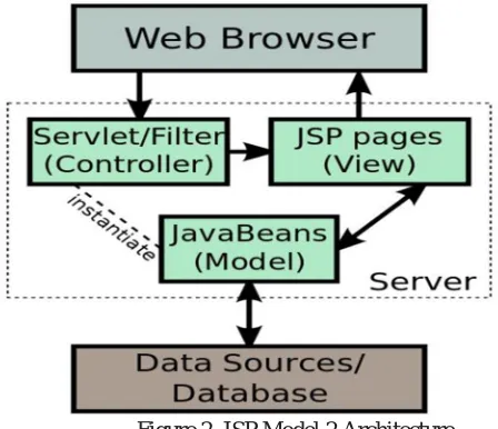
[image:5.612.219.414.89.278.2]Templates
Figure 3. JSP Life Cycle
A JSP life cycle can be defined as the entire process from its creation till the destruction which is similar to a servlet life cycle with an additional step which required to compile a JSP into servlet.
This includes following steps or phases:
JSP page translation- generation servlet source code. The translation occurs only when jsp page has to serve its first request. Translation does not have to happen again unless the page is updated.
JSP page compilation- compile generated code into byte code. Load the class.
Create instance. Call the jspInit method.
Call the jspService method, for each request. Call the jspDestroy method.
V. SYSTEM ARCHITECTURE
[image:5.612.204.405.473.699.2]Technology (IJRASET)
A. User
User has to enter their travellingspecifications like their source and destination. After entering the details, he/she has to proceed to
the next module.
B. Browser
A web browser is a client program that uses HTTP (Hyper Text Transfer Protocol) to make a request of web servers throughout
the internet on behalf of browser user.
C. Travelling Specification
User has to enter thesource and destination and click on the proceed button after that he/she is being directed to the next module
where he/she has to select the particular in which he/she wants to travel from the displayed list of available buses. D. Web Server
A Web server is a program that uses HTTP (Hypertext Transfer Protocol) to serve the files that form Web pages to users, in
response to their requests, which are forwarded by their computers HTTP clients. Dedicated computers and appliances may be referred to as Web servers as well.
E. Database
Database contains the bus detailswhich are being entered in the travelling specification module.
F. Database Server
A database server is acomputer program that provides database services to other computer programs or computers, as defined by
the client–server model.
VI. SUMMARY
[image:6.612.166.391.411.709.2]By using our web application, the source and the destination is being entered, the available buses and the number of routes between that particular source and destination will be displayed from which the user wants to select which he/she wants to take.
Technology (IJRASET)
Once they click on the required bus they will be redirected to a page where the stopping’s right from the source till the destination will be listed. So this will be very much helpful and the user can even have their manual count to get down in the right stopping with the help of our application.
VII. CONCLUSION AND FUTUREWORK
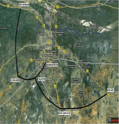
[image:7.612.202.410.161.377.2]In order to make the travelling from one place to another without any dilemma using this tripper’s guide the user can know the details about the buses and the places.
Figure 6. Satellite View of Routes Using GPS
In future,it can be proposed in an Android Application. As of future enhancement, this project can be determined in many other districts. To make this project more efficient in future, we shall implement this in android to make an Android Application. As extending the project to an Android Application the User can access it using SmartPhones. In future, Using GPS satellite view of the routes will be shown for more than one cities.
REFERENCES
[1] L. Bedogni, M. Di Felice, and L. Bononi, “By Train or by Car? Detecting the User's Motion Type Through Smartphone Sensors Data,” Proc. IFIP Wireless Days Conf. (WD 2012), 2012, pp. 1–6.
[2] J. Biagioni et al., “EasyTracker: Automatic Transit Tracking, Mapping, and Arrival Time Prediction Using Smartphones,” Proc. 9th ACM Conf. Embedded Networked Sensor Systems (SenSys 2011), pp. 1–14.
[3] T. Bray et al., Extensible Markup Language (XML) 1.0 (Fifth Edition), W3C, W3C Recommendation REC-xml20081126, Nov. 2008, http://www.w3.org/TR/2008/RECxml-20081126/
[4] P. Eugster et al., “The Many Faces of Publish/Subscribe,” ACM Comput. Surv., vol. 35, no. 2, June 2013, pp. 114–31.
[5] J. Fogarty et al., “Case Studies in the Use of ROC Curve Analysis for Sensor-based Estimates in Human Computer Interaction,” Proc. Graphics Interface 2005, ser. GI ‘05, School of Computer Science, University of Waterloo, Waterloo, Ontario,Canada: Canadian Human-Computer Communications society, 2005,http://portal.acm.org/citation.cfm?id=10895 08.1089530,pp.129–36
[6] R. Ganti, F. Ye, and H. Lei, “Mobile Crowdsensing: Current State and Future Challenges,” IEEE Commun. Mag., Nov. 2011, pp. 32–39. Google Inc., General Transit Feed Specification Conf. Mobile Systems, Applications, and Services (MobiSys 2012), June 2012. Conf. Mobile Systems, Applications, and Services (MobiSys 2012), June 2012.
[7] M. Haklay and P. Weber, “ OpenStreetMap: User-Generated Street Maps,” IEEE Pervasive Computing, Oct. 2008.
[8] P. Millard, P. Saint-Andre and R. Meijer, “XEP-0060: Publish-Subscribe,” XMPP Standards Foundation, Draft Standard XEP-0060, July 2010, http://xmpp.org/extensions/xep-0060.html.
[9] M.Padmadas,Dr.KrishnanNallaperumal, V.Mualidharan, “A Deployable architecture of intelligent transportation system.”,IEEE ,2010.
[10] Ricardo Hoar,” Personalized web based public transit information system user feedback”,13th International IEEE,September,2010 pp 1807-1812.
[11] Siyuan Liu, Jiansu Pu, Qiong Luo, Huamin Qu, Lionel and Ramayya Krishnan,” VAIT: A Visual analytics system for metropolitan transportation, IEEE vol 14,dec 2013,pp 1586-1596.