International Journal of Emerging Technology and Advanced Engineering
Website: www.ijetae.com (ISSN 2250-2459,ISO 9001:2008 Certified Journal, Volume 3, Issue 12, December 2013)
312
Comparative Study of Two Approaches to Implementation of
Electric Dragged of Geophysics in The Framework of
Groundwater Prospecting. Case of An Experience in Cote
d'Ivoire.
Konan Emmanuel KOUADIO1, Arthur Brice KONAN-WAIDHET2, Theodore Koffi YAO3, Theophile LASM4 1Department of Science and Technology of Water and Environmental Engineering, Faculty of Earth Sciences and Mineral
Resources, University Felix Houphouet-Boigny, Abidjan, B.P. 2497, Abidjan 08, Côte d’Ivoire
2Geosciences and Environment Laboratory, Jean Lorougnon Guede University of Daloa, Côte d’Ivoire; B.P. 801,
Abidjan 02, Côte d’Ivoire
3,4Department of Science and Technology of Water and Environmental Engineering, Faculty of Earth Sciences and Mineral Resources, University Felix Houphouet-Boigny, BP 582 Abidjan 22, Cote d'Ivoire
Abstract— In crystalline basement area, geophysical
exploration is to detect discontinuities in the bedrock. So hydrogeologists and Geophysicist proposed to study best the exploration direction to intersect fractures in which water is found. Thus, two different approaches have been tested in the exploration of groundwater in the view to compare their results. Both approaches aim to intersect fractures in the bedrock. The study covers some sites scattered throughout the entire Ivorian territory. Every approach was Funded by a bank: the Kreditantstalt Für Wiederaufbau (KfW) in 2004 and the West African Bank of Development in 2008. The electrical method of geophysics was used, particularly the simple electrical dragged was used to study the variations in the apparent electrical resistivity of the subsurface at a constant depth by lateral movement of instruments. After realizing the boreholes, the results showed that the first approach allowed to get the best water flow rate. Besides, the percentage of success is 69% with this approach and it is 47% for the second approach. According to these results, Geophysicists are advised to prospect groundwater in a direction parallel to trough.
Keywords— bedrock, Côte d’Ivoire, fractures, geophysical exploration, Groundwater.
I. INTRODUCTION
Since the launch of the national program of water in 1973, the Government of Côte d'Ivoire regularly receives financing from donors and international organizations to supply drinking water to urban and rural communities. As funding is limited, it is difficult to use, for all surface waters whose treatment is more expensive. Moreover, some regions have no perennial surface water sources. That is why the water is oriented more towards groundwater [1] (Biémi, 1992). This survey is within the jurisdiction of Hydrogeologists supported by geophysicists.
In crystalline basement area, geophysical exploration is to detect discontinuities in the bedrock. It aims to assess the potential in water of a given area [2] (Bakkali et al, 2004 ) and thus can reveal the existence of fractures, whether conductive or not.
In its implementation, experts in the field, namely, hydrogeologists propose to conduct a priori a study to define the exploration direction for geophysicist and guide it. In the context of projects in Côte d'Ivoire, two different approaches have been tried in the exploration of groundwater cracks. Both approaches aim to intersect fractures in the bedrock. And, to intersect a linear structure, it is necessary to be in a direction perpendicular or, at least, intersecting to the latter. Main fractures and their directions are distinguished through their signatures to the surface of the earth [3] (Koussoubé et al, 2003). These are geomorphological anomalies observed in the field such as troughs, streams, etc. However, geophysical prospecting have shown the existence of several bills that were not necessarily visible trace on the surface and yet many holes drilled in these conditions have been positive. Only the direction of fractures is determined when the survey is conducted in at least two parallel lines on the same site [4] (Savadogo, 1984).
International Journal of Emerging Technology and Advanced Engineering
Website: www.ijetae.com (ISSN 2250-2459,ISO 9001:2008 Certified Journal, Volume 3, Issue 12, December 2013)
313
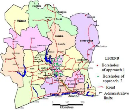
II. OVERVIEW OF ENVIRONMENTAL SETTING The study covers some sites scattered throughout the entire Ivorian territory (Figure 1) that consists of 97.5% of bedrock and 2.5% of coastal sedimentary basin. Although rocks are almost all Precambrian formations, they rarely outcrop, because they are generally covered by alteration products. They can be separated into two superposed orogenic chains: The Libérianides Archean and Proterozoic Eburnéides.
Geology is quite complex in terms of formations encountered. Metamorphic rocks (schist, gneiss, métavulcanites, etc.) dominate the West, East and South of the country. In contrast, the magmatic rocks (biotite granite, two-mica granite, migmatites, granodiorites, etc.) dominate the northern and central [5] (B Tagini, 1971).
[image:2.612.58.273.368.551.2]The hydrographic network of Côte d'Ivoire is quite provided. It is generally dendritic (eg Bandama River). This is an asset for hydrogeological exploration in each locality.
Figure 1 – Location of sites prospected on Ivory Coast territory
III. MATERIALS AND METHODS
A. Description of Approaches
The present study was Conducted Within the framework of the implementation of drinking water supply projects in Côte d'Ivoire. One of the projects was Funded by the German bank Kreditantstalt Für Wiederaufbau (KfW) in 2004 and the other was Funded by the West African Bank of Development (BOAD) in 2008.
Hydrogeologists and geophysicists were recommended to lead the exploration of groundwater. It was a matter for the hydrogeologist to find fractures through their signatures on the surface of the earth [6] (Dewandel et al, 2006) and guide the geophysical prospection. To do this, a detailed analysis was conducted on the Basis of the maps (topographic maps, hydrographic maps, aerial photographs, satellite images) and data from Existing wells in the vicinity.
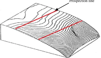
To do this, two approaches were used respectively for the projects monitored. Thus, in the first approach, it was chosen a direction parallel to that of visible abnormalities [2] (Bakkali et al, 2004). It is actually major deformation structures (faults, shear zones, geological contacts, veins). This is easily identified on the ground through troughs and streams. Clearly, the measuring device is placed in a direction parallel to that of troughs or watercourses. The aim is to cross the secondary fractures from the main fracture whose signature is the stream or trough. A compass is used to determine azimuth borrowed for different directions (Figure 2).
Figure 2 - Prospecting direction parallel to the watercourse or trough (Approach 1)
In the second approach, the direction of exploration is perpendicular to the visible signatures of fractures, including troughs and streams. It is in the direction perpendicular to the first case that the measures are taken. However, the geophysical method applied in the above case is not changed. The measuring device is placed in the view to intersect the fractures extended in the direction of the trough covered by the study (Figure 3).
[image:2.612.335.572.390.525.2]International Journal of Emerging Technology and Advanced Engineering
Website: www.ijetae.com (ISSN 2250-2459,ISO 9001:2008 Certified Journal, Volume 3, Issue 12, December 2013)
[image:3.612.54.264.144.266.2]314
Figure 3 - Prospecting direction parallel to the watercourse or trough (Approach 1)
B. Description of the geophysical method applied in both cases
The method used is the electrical method. The apparatus comprises battery 450 V DC, a resistivity of Syscal Iris Instruments type, of two current transmitting electrodes , said A and B and two measurement electrodes of the potential difference , called MN , metal probes, cables and hammers for driving the probe. The sites are in crystalline basement zone where fractures are researched by hydrogeologists and geophysicists because groundwater lodges in these structures. Boreholes need to intercept these structures to hope to produce water. These fractures are identified in the basement areas of low electrical resistivities in a more resistant environment [7] (Sree P.D. et al, 2001).
Geophysical prospection consist in confirming, on the ground, the results of the interpretation of aerial photographs or satellite images, highlighting anomalies through the apparent resistivities and it allows to position identified fractures.
The simple electrical dragged or repeatedly used to study the variations in the apparent electrical resistivity of the subsurface at a constant depth by lateral movement of the NBMA according to a predetermined axis. Lateral variations in resistivity recorded highlight structural changes, including fractured zones which often result in conductive anomalies. Devices with lengths of lines AB and MN are used to study different variations of apparent resistivity at different depths [8] (Chapellier D, 2000).
Using this method allows a qualitative interpretation of the results in the form of profiles or curves that track the spatial and vertical evolution of anomalies [9] (Sultan A.S. et al, 2009).
The Geophysicist performs the a priori of apparent resistivity measurements on a line to highlight the profile of electrical resistivity and electrical dragged.
By means of two injection electrodes at two points A and B located on the surface, an electricity of intensity (I) is injected into the soil. With two other measurement electrodes, the potential difference is carried (V). Depending on the device used (Schlumberger), a geometrical factor is calculated and applied to V/I to calculate the apparent resistivity at the measurement point. This is generally the middle of the device for measuring the potential difference V. The measuring devices can operate using low-frequency alternating current or direct current. In the second case, it is necessary to make corrections due to the spontaneous polarization due to the natural circulation of electricity in the basement.
The resistivity meter used for the prospection is the type SYSCAL IRIS_INSTRUMENTS DC supplied with a car battery of 12 volts. It can develop on output voltages from 12 to 600 volts with a voltage amplifier. The calculation of resistivity is automatically done by a computer coupled to the resistivity. This is a significant advantage with respect to time savings.
Following the interpretation, it is generally in two cases: -if the curve traced don't reveal any discontinuity, the operation is stopped and the measuring device is moved to another site ;
- if at least one discontinuity is suspected through the resistivity curve, then the operation continues by checking the extension of the discontinuity .
To do this two parallel profiles are made with an equidistance of about 30 m on either side of the main profile. This allows confirming the lateral extent of the fracture.
When the discontinuities present a sensitive alignment of the points identified on three profiles, then the existence of a fracture is probable. The items selected are subject to electrical poll to highlight the characteristics of the aquifer. The most favourable point is taken as site of drilling.
IV. RESULTS AND INTERPRETATIONS
A. Results of drilling according to both approaches
International Journal of Emerging Technology and Advanced Engineering
Website: www.ijetae.com (ISSN 2250-2459,ISO 9001:2008 Certified Journal, Volume 3, Issue 12, December 2013)
[image:4.612.66.571.143.657.2]315
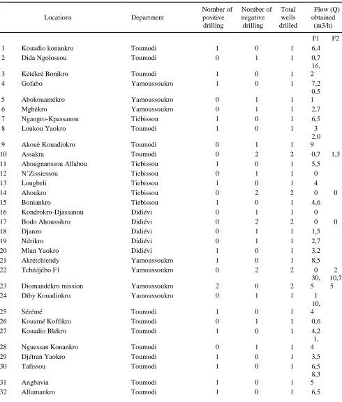
Table I
Results of drilling with Approach 1 (Drilling negative if Q <3 m3 and Drilling positive if Q ≥ 3 m3)
Locations Department
Nomber of positive drilling
Nomber of negative drilling
Total wells
drilled Flow (Q) obtained (m3/h)
F1 F2 F3
1 Amoriakro Agnibilékro 1 0 1 12,6
2
Bayota Gagnoa 2 0 2 7,96
18 ,9
3 Binao Tiassalé 1 2 3 2 0 9,5
4
Bonoufla Vavoua 2 0 2
11,6 3
37 ,8
5 Canton N'goys Sinfra 1 0 1 44,5
6 Dignago Guibéroua 2 1 3 5,04 0 8
7 Doropo Bouna 1 2 3 0 0 24
8
Doukouya Oumé 2 0 2 5,8
16 ,9 9
Gadouan Daloa 2 0 2
13,7 5
16 ,8
10 Iroporia Divo 2 1 3 12,6 0 13
11
Konéfla Sinfra 1 1 2 0
25 ,2
12 Lathaha Korhogo 1 0 1 12,6
13
Loviguié Agboville 2 1 3 0
4,
45 16,8
14
Nambingué Ouangalo 1 0 1
30,2 4
15 Toumoukoro Ouangalo 1 0 1 12,6
16
Abongoua Adzopé 1 1 2 1,7
7, 2
17 Abradinou Abengourou 1 0 1 30 0
18 Bodo Tiassalé 1 0 1 26,4
19 Bondo-Dioula Bondoukou 1 0 1 20
20 Diby Aboisso 2 0 2 5 12
21 Lapo Agboville 1 1 2 0,7 66
22
Nkoupé Adzopé 1 2 3 2
1,
6 7,2
23 Singrobo Tiassalé 1 0 1 50
24 Lobo Akoudzin Adzopé 1 0 1 8
25 Molonou Tiébissou 1 1 2 2,3 9
26 Ngorato Tanda 1 2 3 0,5 2 7,2
Total 34 15 49
International Journal of Emerging Technology and Advanced Engineering
Website: www.ijetae.com (ISSN 2250-2459,ISO 9001:2008 Certified Journal, Volume 3, Issue 12, December 2013)
[image:5.612.70.560.152.729.2]316
Table II
Results of drilling with Approach 2 (Drilling negative if Q <3 m3 and Drilling positive if Q ≥ 3 m3)
Locations Department
Nomber of positive
drilling
Nomber of negative
drilling
Total wells drilled
Flow (Q) obtained
(m3/h) F1 F2
1 Kouadio konankro Toumodi 1 0 1 6,4
2 Dida Ngolossou Toumodi 0 1 1 0,7
3 Kétékré Bonikro Toumodi 1 0 1
16, 2
4 Gofabo Yamoussoukro 1 0 1 7,2
5 Abokouamékro Yamoussoukro 0 1 1
0,5 1
6 Mgbèkro Yamoussoukro 0 1 1 2,7
7 Ngangro-Kpassanou Tiébissou 1 0 1 6,5
8 Loukou Yaokro Toumodi 1 0 1 3
9 Akouè Kouadiokro Toumodi 0 1 1
2,0 9
10 Assakra Toumodi 0 2 2 0,7 1,3
11 Ahougnanssou Allahou Tiebissou 1 0 1 5,5
12 N’Zissiessou Tiebissou 0 1 1 0
13 Lougbeli Tiebissou 1 0 1 4
14 Ahoukro Tiebissou 0 2 2 0 0
15 Boniankro Tiebissou 1 0 1 4,6
16 Kondrokro-Djassanou Didiévi 0 1 1 0
17 Bodo Ahoussikro Didiévi 0 2 2 0 0
18 Djanzo Didiévi 0 1 1 1,5
19 Ndrikro Didiévi 0 1 1 2,7
20 Mlan Yaokro Didiévi 1 0 1 3,2
21 Akrétchiendy Yamoussoukro 1 0 1 8,5
22 Tchédjébo F1 Yamoussoukro 0 2 2 0 2
23 Diomandékro mission Yamoussoukro 2 0 2
30, 5
10,7 5
24 Diby Kouadiokro Yamoussoukro 0 1 1 1
25 Sérémé Toumodi 1 0 1
10, 4
26 Kouamé Koffikro Toumodi 0 1 1 0,6
27 Kouadio Blékro Toumodi 1 0 1 4,2
28 Nguessan Konankro Toumodi 0 1 1
1, 4
29 Djétran Yaokro Toumodi 1 0 1 3,5
30 Tafissou Toumodi 1 0 1 6,5
31 Angbavia Toumodi 1 0 1
8,3 5
International Journal of Emerging Technology and Advanced Engineering
Website: www.ijetae.com (ISSN 2250-2459,ISO 9001:2008 Certified Journal, Volume 3, Issue 12, December 2013)
317
33 Zougoussi Toumodi 1 0 1 4,1
34 Kongoti Toumodi 2 0 2
12, 5 4,6
35 Duibo Kpato Tiébissou 0 1 1 1,3
36 Do Sakassou Tiébissou 1 0 1 4,3
37 Yadibykro Tiébissou 0 1 1 0
38 Ndènou Tiébissou 1 0 1 5,8
39 Yadibykro Tiébissou 0 1 1
1,1 5
40 Allialikro Didiévi 0 1 1 1,2
41 Okoubonou Didiévi 0 2 2 0 1,05
42 Assé Blendoukro Didiévi 0 1 1 0,5
Total 23 26 49
Percentage 47% 53%
The number of boreholes (F1, F2, F3) made in each locality varies between 1 and 3 depending on whether the objective in terms of throughput is reached or not in the first attempts. As part of this project, the minimum flow required is 3 m3/h. Thus, the drilling whose flow is less than this value is said negative while the drilling with a flow rate greater than or equal to 3 m3/h is said positive.
As part of the implementation of Approach 1, the project has realized 49 boreholes in diffrents locations: 34 are positive with a rate of 69% and 15 boreholes are negative with a rate of 31%.
The largest flow rate were obtained at Singrobo (50 m3 / h), Bazré (44.5 m3/h), Bonoufla (37.8 m3/h) and Nambingué (30.24 m3/h). Approximately 47% of drilling have a flow rate more than 10 m3/h,
In Approach 2, the studied sample has a size of 49 wells in 42 villages. On the basis of the minimum required flow rate of 3 m3/h, the following results were obtained: 26 negative wells, 53% and 23 positive wells, or 47%.
The largest flows were obtained Diomandékro Mission (30 m3/h) and Kétékré Bonikro (16 m3/h). Only 10% of drilling more than 10 m3/h.
B. Interpretations and discussions
Both approaches are based on the conceptual understanding of tectonic processes and their propagation in the immediate environment. Thus, the orientation of the fractures has guided the different approaches to implementation of geophysical measurements [10] (Michael J.F, 2012).
Considering the results of the two approaches, it appears the first approach achieves the greatest success rate (69%) compared to the second Approach with a rate of 47%. Also, the rates obtained with Approach 1 are generally higher than Approach 2.
The approach 1 allows to identify the secondary fractures supplied by main fractures and optionally interconnected with other secondary fractures [11] (Lasm, 2000).
The approach 2 in his understanding is to intercept the main fractures identified from hydrogeological studies. Linear structures visible on satellite images or aerial photographs are purely superficial. They certainly reflect the fractures when it comes to troughs or watercourse reality. However, it is not advisable to implement a drilling in the bed of a minor watercourse even dry because this site would be flooded in case of heavy rain. The most favorable results of polls are located out of thalwegs. It is thus not necessary to cross the trough before meetting fracture in the bedrock.
This confirms the fact that the holes drilled in the same villages on trays often produce large flow. For example, the F1 drilling Loviguié is located in a trough but it was unproductive while drilling F2 and F3 located on a slope of the same village respectively produced 4.45 m3/h and 37.8 m3/h. Only F3 is well downstream of F2, the potential for accumulation of water is greater at this point than F2. This would explain the difference in flow rate.
International Journal of Emerging Technology and Advanced Engineering
Website: www.ijetae.com (ISSN 2250-2459,ISO 9001:2008 Certified Journal, Volume 3, Issue 12, December 2013)
318
These results can be explained by the fact that fractures intersected by boreholes are usually secondary fractures. The main fracture could be intersected if the dip of the fracture is known. When a thalweg is dry, it is possible to cross it and implement the geophysical measures, but it is not the same thing for rivers. In this case, the measurements are made on one side and it is not easy to achieve the goal of the approach 1: to intersect the main fracture.
In all cases the geological environment influences the hydraulic potential of a given area. In addition, the zones studied are quite dispersed, and each one has its own geological and hydrogeological characteristics.
The aquifer properties and water flow of boreholes in crystalline area depend on parameters such as the number, length, orientation and density of lineaments [13] (Summers, 1972). Previous studies have shown that fractures parallel to the direction of compressive stresses are open, while those that are orthogonal to the tectonic stresses are closed [14] [15] (Engalenc 1981; Savané et al, 1993). Indeed, the fractures of the direction North-South and his dispersions are parallel to constraints, so they are open. Besides, the direction North-East, or more precisely the direction N40°, corresponding to the Birimian direction is considered as the pressure distortion.
However, the fractures of the orientation North-west (NW), are waterproof because they are perpendicular to constraints. It is the same for the east-west fractures (EW).
Directions of fractures are therefore questionable because some of them are open and others are closed. Those that are open are likely to store water, so favorable to productivity books, while those that are closed can not play the hydraulic role conferred on them.
However, the fractures of the orientation North-west ( NW)27844, are waterproof because they are perpendicular to constraints. It is the same for the east-west fractures (EW) .
Directions of fractures are therefore questionable because some of them are open and others are closed. Those that are open are likely to store water, so favorable to productivity books, while those that are closed can not play the hydraulic role conferred on them.
Accordingly, the fractures are not all productive. The studies of [14] Engalenc (1981) showed that the frequency of fractures is a favorable factor for water storage and water flow, but a high frequency of fractures is not necessarily a criterion of productivity. However, the fracture density influences the chances of successful drilling.
The petrographic nature of training also affects the productivity of drilling [16] (Kouadio, 2005). A study in Mogtédo, Burkina Faso, showed that the fractures are more frequent in foliated rocks.
From a statistical study, it showed that the holes drilled in these structures have proved to be more productive.
Also, [17] Fernandes (1997), in a similar study in Brazil, he showed that fractures borrow the foliation planes .
C. Limitations of the study
Both approaches have been applied to fields of different geological characteristics. This may explain the difference in results since the degree of fracturing depends on the petrographical nature of formations [16] (Kouadio, 2005).
In addition, the first approach has been applied to a large space (South and North), and therefore likely to contain a greater variety of rocks. Thus the chances of meeting very productive sites is more likely.
The second approach was applied in a more restricted (center) space. This can reduce the chances of encountering very contrasting geological and hydrogeological structures which may influence the characteristics of groundwater. [18] Siddiqui S.H. and Parizek R. R. (1971).
The studies were conducted in the context of development projects with the aim of achieving economic work. It was therefore not possible to guide the work as in the case of research activities. All these factors may partly explain the difference in results.
V. CONCLUSION
In both approaches, geophysical exploration is made in a direction which intersects the fractures, so that their presence can be detected through the values of apparent resistivity. The first approach allows getting 69% of positive boreholes against 47% for the second approach.
In reality, the boreholes realized according to the Approach 2 show no particular geomorphological positioning compared to Approach 1. This is due, firstly, to the fact that the latest measures are made before the bed of stream and, secondly, it is necessary to facilitate access to boreholes and avoid flooding. Thus, the comparative analysis shows that the flow rates of all fractures are often in the same order of size and even larger with the results of approach 1.
In short both approaches intersect secondary fractures. Only the analysis of resistivity profiles shows that the probability to get fractures is higher with Approach 1 than Approach 2. In addition, the larger water flow rates were obtained with Approach 1 which presents itself as the most suitable.
However, the geological and hydrogeological conditions determine the characteristics of completed works.
International Journal of Emerging Technology and Advanced Engineering
Website: www.ijetae.com (ISSN 2250-2459,ISO 9001:2008 Certified Journal, Volume 3, Issue 12, December 2013)
319
Acknowledgement
We want to address our thanks to the different banks (KfW and BOAD) for the financing of the projects. We also thank the National office for drinking water (ONEP) and Pader-Lacs for their helping and collaboration without which this study would not have been possible.
REFERENCES
[1] Biemi J., 1992. Contribution of the geological, hydrogeological and remote sensing study subsahéliens watersheds of the Precambrian basement of West Africa: hydrostructurale, hydrodynamics, hydrochemistry and isotopic discontinuous aquifers furrows and granitic areas of high Marahoué (Côte d'Ivoire). State thesis in Natural Sciences, University of Abidjan, 424 p
[2] Bakkali S., and Bouyalaoui J. Geophysical Prospecting applied to the evaluation of groundwater of Médiouna (Tangier, Morocco). Journal of Engineering Sciences, No. 4/2004, pp. 13-22
[3] Koussoubé Y., Nakolendoussé S., and Savadogo A.N. The different signatures fractures in crystalline rocks of Sudano-Sahelian zone of Burkina Faso (watershed Bidi, Yatenga) . Remote Sensing, 2003, vol. 3, No. 5, p. 419-427
[4] Savadogo N.A, 1984. Geology and hydrogeology of the crystalline basement of the Upper Volta. Regional Study Watershed Sissili. PhD in Natural Sciences, Scientific and Medical University of Grenoble, 351 pages
[5] Tagini B., 1971. Structural Outline of Côte d'Ivoire, regional geotectonic test. Thesis, University of Lausan.
[6] Dewandel B., Lachassagne P., Wins R., Marechal J.C. and Krishnamurthy N.S., 2006. A generalized 3-D geological and hydrogeological conceptual model of granite aquifers controlled by single or multiphase weathering. J. Hydrol., 330, 260-284.
[7] Sree P.D., Srinivasulu S., Kesava K.R., 2001. Delineation of groundwater potential zones and electrical resistivity studies for groundwater exploration. Environmental Geology, Volume 40, Issue 10, pp. 1252-1264
[8] Chapellier D, 2000. Electrical Prospecting surface. Online course of geophysics - electrical resistivity. University of Lausanne, French Institute of Applied Geophysics, 102 p.
[9] Sultan A.S., Hatem M.M., Fernando M.S., 2009. Groundwater exploration and appraisal by using geophysical interpretation (case study: Al Qantara East, North Western Sinai, Egypt). Arabian Journal of Geosciences, Volume 2, Issue 3, pp. 199-211
[10] Michael J.F., Oderson A.S.F., Fabio I., Adalene M.S., Sueli Y., 2012. Data-driven modeling for groundwater exploration in fractured crystalline field, Northeast Brazil. Hydrogeolgy Journal, Volume 20, Issue 6, pp. 1061-1080
[11] Lasm T., 2000. Hydrogeology of fractured reservoirs of base: statistical analysis and geostatistics fracturing and hydraulic properties. Application to the Region of Hydrogeology Prospecting in Crystalline and Metamorphic Area by Spatial Analysis of Productivity Potential 390 Mountains Côte d'Ivoire (Domain Archean). PhD thesis, University of Poitiers, 272 p.
[12] Dieng B., Kouassi A.H., and Bakyono B.A. Optimization of the geophysical location of drilling base area in northern Burkina Faso. South Science and Technology, No. 12 - June 2004, pp. 21-30 [13] Summers W.K., 1972. Specific Capacities of wells in crystalline
rocks. Groundwater, Vol.10, No. 16, pp. 37-47
[14] Engalenc, 1981. Study and research of groundwater in crystalline rocks of West Africa, Volume 3 method. Atlas photo-interpretation. CIEH, Géohydraulique, 38 p.
[15] Savané I, Bénié G.B., Gwyn Q.J.H., and Biémi J. Application of remote sensing research of groundwater crystalline medium: Odienné, Côte d'Ivoire. Science news (as) AUPELF-UREF. Remote sensing of water resources. Proceedings of scientific conference in Tunis in 1993, pp. 111-120
[16] Kouadio K.E., 2005. Prospecting Strategy of groundwater by spatial analysis of potential productivity and optimize depth of drilling. Case of Denguélé region (Northwest of Ivory Coast). PhD Thesis, University of Cocody, Abidjan, Cote d'Ivoire, 181 p.
[17] Fernandes A. J (1997) – Cenozoic tectonics in the middle portion of the Piracicaba River basin and its application to the hydrogeology of fractured media (in Portuguese). – PhD Thesis, University of Sâo Paulo.