Virtual Blind Navigation Device with
Interactive Assistance
J.Rajeswari1, A.Shunmugalatha2, A.Farhana3 , N.Karthiyayini4
Assistant Professor, Dept. of EEE, Velammal College of Engineering and Technology, Madurai, Tamilnadu , India1
Professor and Head, Dept. of EEE, Velammal College of Engineering and Technology, Madurai, Tamilnadu, India2
UG Student, Dept. of EEE, Velammal College of Engineering and Technology, Madurai, Tamilnadu, India3
UG Student, Dept. of EEE, Velammal College of Engineering and Technology, Madurai, Tamilnadu, India4
ABSTRACT: A smart device with several features in order to help the blind person to walk efficiently and safely on the indoor and outdoor environment. The blind persons are not able to find the locations and obstacles, to this issue navigation system with a smart device. This includes a location finding guide, obstacles detecting sensors, with an E-speaker based on the IoT. Raspberry pi3 controller is used for information transferring and storage purpose. To capture the things and to detect the way IP webcam server is linked with the mobile camera. Ultrasonic sensor is used for detecting the obstacles on the indoor and outdoor environment. These are the key component on the smart device that a blind person would easily carry with them. This smart stick is based on the IoT with an internal structural design with it.
KEYWORDS: Ultrasonic sensor, GSM Module, Raspberry Pi controller.
I. INTRODUCTION
II. KEY FEATURES OF THE SYSTEM
The main key features of proposed security system are Indoor and Outdoor localization ,
There are many wireless localization systems that utilize UWB (Ultra Wide Band) radar, and RFID (Radio Frequency Identification). UWB radar has been a particularly attractive technology for indoor localization because it is not susceptible to interference from other signals (due to its drastically different signal type and radio spectrum), and the UWB signal (especially the low frequencies included in the broad range of the UWB spectrum) can penetrate a variety of materials, including walls [1]. UWB radar achieves very high localization accuracy, which can be up to 10 cm [4]. The slow progress in the UWB standard development has limited the use of UWB in consumer products and portable user devices. RFID based systems can be used for localization and object tracking as they have a reasonable range, low cost and can be easily embedded in the tracking objects[7]. However, the limited range makes them unsuitable for high precision indoor localization.
It is favourable for localization of sensors in WSN (Wireless Sensor Network), but it is not suitable for indoor localization as it cannot provide the distance between the user and the labelled sensor [12]. Most of the existing bluetooth based localization systems relay on RSSI (Received Signal Strength Indicator), however, they are prone to multipath fading and environmental noise, lower localization accuracy due to its signal band which is the same with other signals. Thus, only bluetooth based localization system has very large uncertainty in localization. Most of portable consumer devices (e.g. smart phones, laptops) are Wi-Fi enabled [6], for indoor and outdoor localization. However, existing Wi-Fi networks are normally deployed for communication rather than localization purposes. Therefore their localization accuracy still needs improvement, by connecting web camera server with the Wi-Fi network.
B. Way-Finding and Route Following
The sparse map built by the Google assistance is used for providing the global path. An algorithm was adopted as the way-finding [10]. After the globally shortest path from the starting position to the destination was found, the route following algorithm will provide accurate guidance information to ensure that the user can follow the globally shortest path and avoid obstacles. The route following algorithm in takes the globally shortest path and an advanced knowledge of indoor environment as inputs, and outputs a control strategy that makes the user’s trajectory remain close to the globally shortest path [5]. It selects some special nodes (e.g. entrance node, room node and intersection node, etc.) as sub-goals to guide the user.
A path deviation detecting method which is based on measuring the similarity between the current frame and the training frame of the pre-defined path [10].The dynamic obstacles and changes of the environment were not considered. Hence, it is not able to help the blind avoid dynamic obstacles but to overcome the above problems, a dynamic sub-goal based route following algorithm was proposed in this system. The sub-goal is selected dynamically, which includes but is not limited to the special node as mentioned. The above route following algorithm combining the obstacle detecting method which takes the dynamic obstacles and changes of environment into account, and the globally shortest path, output the optimal walkable direction to ensure the user follow the globally shortest path closely at the same time we avoid the obstacles [3].
.
III. SYSTEM SETUP
A. BLOCK DIAGRAM
Fig 1 Block Diagram
The block diagram consists of Raspberry pi3 controller that acts as the mini computer, consists of both input and output pins. The ultrasonic sensor is fused with it for obstacle detection, RF transmitter is used for find the device if it missed , by transmitting the radio frequency signal , Wi-Fi is used for web cam server connections. Secured digital input output is used for securing the data stored.
V. MODULES WITH WORKING PRINCIPLES
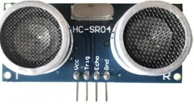
A. Ultrasonic Sensor
The architecture of this sensor is shown in the fig.2. It measures distance by using ultrasonic waves. The sensor head emits an ultrasonic wave and receives the wave reflected back from the target. Ultrasonic sensor measures distance to the target by measuring the time between the emission and reception. Ultrasonic sensor is used to detect any obstacle from the receiver side.
Fig.2 Ultrasonic sensor
B. Raspberry Pi3
Fig .3 Raspberry Pi3
C.GSM Module
GSM (Global System for Mobile communication) is a digital mobile network that is widely used by mobile phone users. GSM uses a variation of time division multiple access and is the most widely used for the three digital wireless telephony technologies. It is the part of the evolution of wireless mobile telecommunication that includes High-Speed Circuit-Switched Data, Universal Mobile Telecommunications Service
Fig .4 GSM Module
D.IP Webcam
IP Webcam is an Android app that lets you transform your phone into a network camera which will let you remotely view videos that are captured real-time. You can view the video via a browser or stream it over your phone.
An Internet Protocol camera, or IP camera, is a type of digital video camera that receives control data and sends image data via the Internet. They are commonly used forsurveillance. Unlike analogclosed-circuit television (CCTV) cameras, they require no local recording device, but only a local area network.
Fig.6 IP Webcam server
VI. RESULT AND CONCLUSION
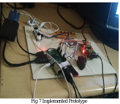
Fig 7 Implemented Prototype
In the fig.7, the implemented prototype for the visually impaired groups to help them reach the destination safely and efficiently is illustrated. A smart device, with several features is introduced here, in order to help the blind person to walk very easily. The proposed navigation device consists of an IP web camera and an ultrasonic rangefinder, an embedded monitor, and an earphone.
following is to make sure the blind person follow the planned path. The ultrasonic sensor shown in Fig.2, fitted at the bottom of the device for detecting the obstacles in front of the person. On the top Raspberry pi3 controller is placed with the mobile display for monitoring the path along with the Earphones. GPS used for sharing and locating the persons.
VI.CONCLUSION
In order to solve the common aiming problem for blind users, we have proposed a region of interest method to detect the object, while the blind user simply shakes the object for a couple of seconds. This method can effectively distinguish the object of interest from background or other objects in the camera view. To extract text regions from complex backgrounds, we have proposed an edge based text region extraction. The corresponding feature maps estimate the global structural feature of text at every pixel. The localized text regions are transformed into audio output for blind users by using text to speech synthesizer. The sensors embedded on the device have the characteristics of low cost, small size and easy integration. Thus, it has great potential in consumer market, especially electronic travel aids market.
REFERENCES
[1] JinqiangBai, ShiguoLian, Member, IEEE,Zhaoxiang Liu, Kai Wang, DijunLiu.“Virtual-Blind-Road Following Based Wearable Navigation Device for Blind People”, Jan. 2018,pp99,2018.
[2] S.Bhatlawande,M.Mahadevappa, J.Mukherjee, M. Biswas, D. Das and S. Gupta, “Design, development, and clinical evaluation of the electronic mobility cane for vision rehabilitation,” IEEE Trans. Neural Syst. Rehabil. Eng., vol. 22, no. 6, pp. 1148-1159, Nov. 2014.
[3] D.DakopoulosandN. G. Bourbakis, “Wearable obstacle avoidance electronic travel aids for blind: A survey,” IEEE Trans. Syst., Man, Cybern., vol. 40, no. 1, pp. 25-35, Jan. 2010.
[4] A. Aladrén, G. Lopez Nicolas, L. Puig and J. J. Guerrero, “Navigation assistance for the visually impaired using RGB-D sensor with range expansion,” IEEE Systems J., vol. 10, no. 3, pp. 922-932, Sept. 2016.
[5] M. Bousbia-Salah, M. Bettayeb and A. Larbi, “A navigation aid for blind people,” J. Intell.Robot. Syst., vol. 64, no. 3, pp. 387-400, May 2011. [6] Penizzotto, E. Slawinski and V. Mut, “Laser radar based autonomous mobile robot guid system for olive groves navigation,” IEEE Latin America Trans., vol. 13, no. 5, pp. 1303-1312, May 2015.
[7] Y. H. Lee and G. Medioni, “Wearable RGBD indoor navigation system for the blind,” ECCV Workshops (3), 2014, pp. 493-508.
[8] M. C. Kang, S. H. Chae, J. Y. Sun, J. W. Yoo and S. J. Ko, “A novel obstacle detection method based on deformable grid for the visually impaired,” IEEE Trans. Consum. Electron., vol. 61, no. 3, pp. 376-383, 2015
[9] M. C. Kang, S. H. Chae, J. Y. Sun, S. H. Lee a nd S. J. Ko, “An enhanced obstacle avoidance method for the visually impaired using deformable grid,” IEEE Trans. Consum. Electron., vol. 63, no. 2, pp. 169-177, May 2017.
[10] H. Wu, A. Marshall and W. Yu, “Path planning and following algorithms in an indoor navigation model for visually impaired,” in 2nd Int. Conf. Internet Monitoring and Protection (ICIMP 2007), San Jose, 2007, pp. 38-38.
[11] W. C. S. S. Simões and V. F. de Lucena, “Blind user wearable audio assistance for indoor navigation based on visual markers and ultrasonic obstacle detection,” in 2016 IEEE Int. Conf. Consum.Electron. (ICCE), Las Vegas, 2016, pp. 60-63.