Short communication
Earth Observation Actionable Information
Supporting Disaster Risk Reduction Efforts in a
Sustainable Development Framework
Alberto Lorenzo-Alonso1,*, Marino Palacios1 and Ángel Utanda1 1 Indra, Mar Egeo 4, 28830 San Fernando de Henares, Spain
* Correspondence: [email protected]; Tel.: +34-91-627-3292
Abstract: Disaster Risk Reduction (DRR) is a high priority on the agenda of main stakeholders involved in sustainable development and Earth Observation (EO) can provide useful, timely and economical information in this context. This short communication outlines the European Space Agency’s (ESA) specific initiative to promote the use and uptake of satellite data in the global development community: ‘Earth Observation for Sustainable Development (EO4SD)’. One activity area under EO4SD is devoted to Disaster Risk Reduction: EO4SD DRR. Within this project, a team of European companies and institutions are tasked to develop EO services for supporting the implementation of DRR in International Financial Institutions’ (IFI) projects. Integration of satellite-borne data and ancillary data to generate insight and actionable information is thereby considered a key factor for improved decision making. To understand and fully account for the essential user requirements (IFI & Client States), engagement with technical leaders is crucial. Fit-for-purpose use of data and comprehensive capacity building eventually ensure scalability and long-term transferability. Future perspectives of EO4SD and DRR regarding mainstreaming are also highlighted.
Keywords: Disaster Risk Reduction; EO4SD; Official Development Assistance; Actionable Information; World Bank; International Financial Institutions
1. Introduction
The impact of natural hazards on lives and economy are of prime importance to society, especially for developing countries, where mortality is disproportionately high and material losses can have a catastrophic impact in economies. The roadmap to reduce these impacts is laid out in the Sendai Framework for Disaster Risk Reduction 2015-2030 (Sendai Framework). The aim of this initiative is to reduce the number of affected people and disaster-induced casualties, minimize direct economic loss and reduce disaster damage to critical infrastructures and basic services. The broader thematic framework of the United Nations (UN) 2030 Agenda for Sustainable Development with its 17 Sustainable Development Goals (SDGs) also recognizes the opportunities to achieve SDGs though reducing disaster risk. Finally, the Paris Agreement within the United Nations Framework Convention on Climate Change (UNFCCC), as third pillar of the global policy framework, stresses the importance of having a risk assessment and management strategy and the need of reducing risks related to climate change.
According to the World Bank (WB), over the past 30 years, more than 2.5 million people and almost US$ 4 trillion have been lost due to natural disasters [1]. Events occurred during 2017 accounted for economic losses of about US$ 337 billion. They are a reflection of the typically most devastating events worldwide: hurricanes in the Caribbean; tropical storms and severe rains in the Philippines and Zimbabwe; Earthquakes in Mexico and Iran/Iraq; floods in India, Sierra Leone, Colombia, Sri Lanka, Peru and Nepal; snowstorms in Afghanistan and Pakistan; heatwaves in India and landslides in Congo and Bangladesh. The number of people affected by disasters, since 1900 and excluding high-income economies, is highest in East Asia (especially China, Philippines, Indonesia,
Viet Nam and Thailand); South Asia (India); America (Mexico, Central America and Colombia) and Africa (Sahel area affected by droughts) [2]. The historical distribution of events and associated impacts on population and assets provide a starting basis for implementing disaster disk deduction efforts.
Figure x.
World map representing the country classification by incomes, based onhttps://datahelpdesk.worldbank.org/knowledgebase/articles/906519-world-bank-country-and-lending-groups; grey scale ranges from high income (light grey) to low income countries (dark grey). (Coordinate System: Sphere Mollweide; Map scale 1:300.000.000). Proportional symbols represent the total amount of population (in millions of people) affected from 1900 to the present by different types of Natural disasters, excluding the high incomes countries. The groups are based on D. Guha-Sapir, R. Below, Ph. Hoyois - EM-DAT: The CRED/OFDA International Disaster Database – www.emdat.be – Université Catholique de Louvain – Brussels – Belgium classification. (a) Climatological disasters, including droughts, glacial lake outbursts and wildfire; (b) Geophysical disasters, counting earthquakes, mass movement (dry) and volcanic activity; (c) Meteorological, including storms, extreme temperature and fogs; (d) Hydrological including floods, landslides and wave action
2. THE SETUP: Disaster Risk Reduction for Sustainable development
Charter Space & Major Disasters, Sentinel Asia and the Copernicus Emergency Management Service (EMS).
Currently, the Development Aid community requires a more comprehensive approach to address DRR issues and the EO community is looking at both disaster risk response and mitigation [4]. For instance, in the International Forum on Satellite EO and Geohazards [5], an important part of the discussions about the community objectives were about hazard identification, quantification and monitoring for prevention and preparedness. Complementary to disaster response and recovery, risk prevention and preparedness look at DRM issues outside an emergency basis. Different actors in the domain of Official Development Assistance (ODA) and the International Financial Institutions (IFI) are increasingly supporting initiatives to better understand hazards and mitigate risks, considering these different phases of DRM.
The United Nations Office for Disaster Risk Reduction (UNISDR) considers that “disaster risk reduction includes disciplines like disaster management, disaster mitigation and disaster preparedness, but is also part of sustainable development” [6]. The United Nations Development Programme (UNDP) states that every dollar invested in the reduction of vulnerability of population to disasters saves around seven dollars in economic losses [7]. The Directorate-General for Humanitarian Aid and Civil Protection (ECHO) of the European Commission indicated that every dollar invested in resilience saves between four and seven in response [8]. The Addis Ababa Action Agenda [9], a global framework for financing development post-2017, promotes the support to national and local capacity for the application of prevention, adaptation and mitigation measures. The United Nations Sustainable Development Goals recognizes expressly the urgent need to reduce the risk of disasters [10].
Consequently, Development Aid community is integrating the concept of DRR in their operational approaches. The Sendai Framework for DRR asserts that the state has the primary responsibility to reduce disaster risk, which “should be shared with other stakeholders including local governments and the private sector between others” [11].
3. THE CONCEPT: From satellite data to Actionable information
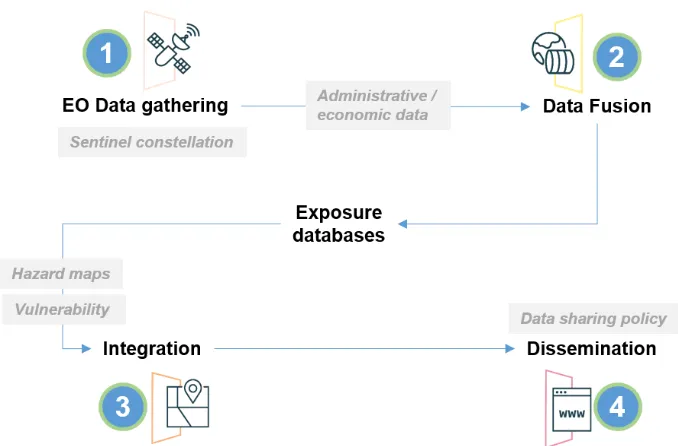
From the supply side, EO specialists of the geospatial information community are promoting an integrated and applied perspective in disaster risk applications [12]. From the demand side, stakeholders and actors are requiring standardized products and services for risk assessment according to the first priority of the Sendai Framework of understanding risks [13] and users are demanding Actionable Risk Information [14] in an accessible, credible and useful format. The ultimate goal of this approach is to allow stakeholders and actors to identify and characterize natural hazards and exposure of people, assets, livelihoods and ecosystems to these hazards, determine vulnerabilities and support mitigation measures with location-specific information.
Figure-Error! No text of specified style in document.-1 DRR actionable information concept
In this sense, the availability of satellite data ‘as and when needed’ is one of the key aspects in the provision of DRR actionable information. The current increase in availability and accessibility of EO missions data via cloud platforms allowing quick and efficient access (e.g. Copernicus Data and Information Access Services -DIAS-) [15], can therefore have decisive impact in DRR. Thus, open data from ESA’s Sentinel missions (especially the Sentinel 1 and Sentinel 2 missions) change the paradigm of very high-resolution commercial satellite imagery traditionally serving as main and often exclusive source of useful EO data for DRR. Sentinel satellites observe all global landmass every 5 days at 10 meters resolution and resulting imagery is provided under the Copernicus program’s free and open data policy. Copernicus ensures a continuous and long-term guaranteed source of valid data for operational use. Sentinel data allows for the developing of new information products, improving the spatial and temporal resolution of existing products or merging it with other data sources.
Figure Error! No text of specified style in document.-2 Sentinel 1: Sensor, Sentinel-1A; Resolution: 10 m.; Date: 23/05/2018; Product: composition: VV, VH, VH in RGB. Sentinel 2: Sensor, Sentinel-2B; Resolution: 10 m.; Date: 23/05/2018; Product: composition bands 11, 8 and 3 in RGB. Sentinel 3: Sensor, Sentinel-3A; Resolution: 1 km.; Date: 23/05/2018; Product: Bright temperature (RBT). Sentinel 1: Sensor, Sentinel-5P; Resolution: 7 km.; Date: 28/06/2018; product: UV Aerosol Index.
4. THE INITIATIVE: Earth Observation for Sustainable Development
concerning understanding and managing risks. Looking at international collaborations about satellite EO and DRR both the Group on Earth Observation (GEO) and the Committee of Earth Observing Satellites (CEOS) are supporting a range of initiatives such as the Geohazards Supersites and Natural Laboratories, the GEODARMA initiative, the GEO EO4SDG, the CEOS Working Group Disasters just to cite a few.
The European Space Agency (ESA) is a contributor to both GEO and CEOS. It is collaborating with global development bodies (UN, IFI, etc.) and runs initiatives to demonstrate the value of satellite environmental information for sustainable development. Since 2008, ESA initiated and is now scaling up a collaboration with the Development Aid community and with a primary focus on IFI. The strategic vision is to ‘transfer and mainstream satellite environmental information into Development Aid operations, activities & financing’ [16]. Previously, and following a set of small-scale pilot projects in collaboration with the World Bank during 2008-2009, ESA had initiated the “eoworld” (Earth Observation for Development) initiative, implemented in two phases between 2010 and 2016. Following in 2016, EO4SD (Earth Observation for Sustainable Development; http://eo4sd.esa.int) was launched as a new program focused on larger-scale regional demonstrations. Identified users of these initiatives are IFI such as World Bank, Asian Development Bank and other Multi-Lateral Development Banks as well as their client states.
Under EO4SD, ESA launched a series of large actions based on thematic service clusters provided by the European EO service sector, which are implemented in the timeframe 2016-2021 for several application areas. Starting with an initial batch of three clusters in 2016, a second batch of further four clusters followed in 2018 including one dedicated to Disaster Risk Reduction (DRR). The approach for these clusters is to increase the uptake of satellite-based information by IFI, Multilateral Development Banks and their Client States with a user-driven approach and a long-term perspective with the intention of mainstreaming EO-based products and services in their work practices. To achieve it, there is the need of ensuring fit to purpose in addition to transferability and scalability.
Stakeholder engagement, one of the initial projects tasks, seeks to understand user requirements of the Client States that are the beneficiaries of IFI projects by contacting and dialoguing with Technical Team Leaders and project leaders. ESA’s long-standing partnership with IFI allows this dialogue to be fully integrated in the activity cycles of these actors of international development. Institutions related to disaster risk management provide the user requirements from the side of Client States. This first identification of user needs is followed by the definition of a fit-for-purpose cluster of services that better matches the executing team’s capacities with the needs of users in terms of types of products and applicability.
Transferability of EO services requires to build capacity to understand the value of the services, to embed the services in their practices and, when possible, to transfer geo-information production and analytics in developing countries. Mature services mean proven and standardized methodological approaches that can be easily transferred, with a delta of customization for each provided service. Besides, horizontal transferability between Client States, projects of the same or even different IFI, and from local-regional to global level is ensured by carrying out regional demonstrations at a large geographic scale for key regions (Africa, South & East Asia and Latin America) with a view to achieve acceptance and adoption in beneficiary countries. Finally, scalability is ensured by focusing the services supply chains on open data when possible (such as using the Sentinel missions) and generally applying data at spatial and temporal resolutions adequate for client needs.
5. The project: EO4SD DRR
exposure, vulnerability and risk assessment and reconstruction monitoring, landslides analysis, earthquake hazard scenarios, subsidence monitoring, tsunami hazard modelling, flooding hazard modelling, storm surge/coastal flood analysis, drought monitoring and wild fires analysis.
However, products and services are of limited utility if their scope is too wide, therefore, the project foresees a next step of customization of services in a pull approach. The initial portfolio of mature services will be fine-tuned to match adequately user needs. During the project lifetime, these services will be applied to a selection of countries and regions based on priorities elaborated with IFI stakeholders and consequently transferred via capacity building activities to champion users. The long-term goal is to achieve an impact by demonstrating the benefit of EO products and services to support DRR in the Development Aid community.
Author Contributions: Conceptualization, M.P. and A.L.; Writing-Original Draft Preparation, A.L. and M.P; Writing-Review & Editing: A. L., M.P. and A.U.
Acknowledgments: Philippe Bally and Christoph Aubrecht for providing significant refinement of the text. César Morate (Indra) and Carmelo Alonso (Indra) for the figures design. María Encina Aulló Maestro (Indra) for the revision of the text. The EO4SD Disaster Risk Reduction is a project funded by ESA.
References
1. Disaster Risk Management. Available online:
https://www.worldbank.org/en/topic/disasterriskmanagement/overview (accessed on 19 September 2018). 2. Swiss Re Institute. 2018. Sigma. Natural catastrophes and man-made disasters in 2017: a year of
record-breaking losses. Available online: http://www.swissre.com/library/publication-sigma/sigma_1_2018_en.html (accessed on 19 September 2018).
3. Voigt, S.; Giulio-Tonolo, F.; Lyons, J.; Kučera, J.; Jones, B.; Schneiderhan, T.; Platzeck, G.; Kaku, K.; Hazarika, M.K.; Czaran, L.; Li, S.; Pedersen, W.; James, G.K.; Proy, C.; Muthike, D.M.; Bequignon, J.; Guha-Sapir, D. Global trends in satellite-based emergency mapping. Science, Special Edition hazards. 2016, VOL 353 ISSUE 6296; pp. 247-252.
4. Van Westen, C.J. Remote sensing and GIS for natural hazards assessment and disaster risk management. In Treatise on Geomorphology, vol.3; Shroder J.F.; Bishop, M.P., Eds.; Academic Press, San Diego, CA,USA, 2013; pp. 259–298.
5. Bally, Ph. Satellite Earth Observation for Geohazard Risk Management. The Santorini Conference, Santorini, Greece, 21–23 May 2012; Fletcher, K. ESA Communications: Noordwijk, The Netherlands, 2014. 6. What is Disaster Risk Reduction?. Available online: https://www.unisdr.org/who-we-are/what-is-drr
(accessed on 19 September 2018)
7. Putting resilience at the Heart of Development: Investing in Prevention and Resilient Recovery. Available online: http://www.undp.org/content/undp/en/home/librarypage/crisis-prevention-and-recovery/putting-resilicence-at-the-heart-of-development.html (accessed on 19 September 2018)
8. European Commission. Commission Staff Working Document. General Guidelines on Operational Priorities for Human Aid in 2016. Brussels, 26.11.2015 SWD(2015) 267 final
9. Addis Ababa Action Agenda of the Third International Conference on Financing for Development. Addis Ababa, Ethiopia, 13-16 July 2015. United Nations, New York, 2015.
10. Disaster Risk Reduction and Resilience in the 2030 Agenda for Sustainable Development. Available online: https://www.unisdr.org/files/46052_disasterriskreductioninthe2030agend.pdf (accessed on 20 September 2018)
11. Sendai Framework for Disaster Risk Reduction. Available online: https://www.unisdr.org/we/coordinate/sendai-framework (accessed on 20 September 2018)
12. Aubrecht, C. Ed. https://www.mdpi.com/journal/ijgi/special_issues/disaster-manag
13. Words into Action Guidelines, National Disaster Risk Assessment, Governance System, Methodologies, and Use of Results, United Nations Office for Disaster Risk Reduction, 2017. Available online https://www.unisdr.org/we/inform/publications/52828 (accessed on 26 September 2018).
14. Himmelfarb, E. P.,Wyan, A. The International Bank for Reconstruction and Development. The World Bank. Available online http://documents.worldbank.org/curated/en/486381468183897622/Understanding-risk-producing-actionable-information-proceedings-from-the-2014-UR-forum (accessed on 26 September 2018). 15. Copernicus Data Access. Available online http://copernicus.eu/data-access. (accessed on 27 September
2018).