Scholarship@Western
Scholarship@Western
Electronic Thesis and Dissertation Repository
5-11-2018 10:00 AM
The Creative Destruction of Place in an Ontario Heritage
The Creative Destruction of Place in an Ontario Heritage
Conservation District
Conservation District
Wes KinghornThe University of Western Ontario
Supervisor Hopkins, Jeff
The University of Western Ontario Graduate Program in Geography
A thesis submitted in partial fulfillment of the requirements for the degree in Doctor of Philosophy
© Wes Kinghorn 2018
Follow this and additional works at: https://ir.lib.uwo.ca/etd
Part of the Human Geography Commons
Recommended Citation Recommended Citation
Kinghorn, Wes, "The Creative Destruction of Place in an Ontario Heritage Conservation District" (2018). Electronic Thesis and Dissertation Repository. 5405.
https://ir.lib.uwo.ca/etd/5405
Abstract
Woodfield is a neighbourhood in the historic core of London, Ontario, Canada that
contains two designated Heritage Conservation Districts (HCDs); the East and West
Woodfield HCDs, designated in 1992 and 2008, respectively. This thesis considers the
impacts of the designation of these two HCDs on the sense of place experienced by
residents, and the ways in which the HCD plans support or challenge the physical and
community aspects of place that are valued by the interviewed residents. This research
is grounded in the geographical literature related to the concepts of place, sense of
place, place branding, heritage conservation, gentrification and ultimately the
geographical theory of creative destruction.
Four objectives guided this research: 1) to identify explicit and implicit references to
sense of place, along with the power dynamics that are created and reinforced in the
HCD government texts; 2) to reveal whether the HCD texts have had an impact,
implicitly or explicitly, on the experienced sense of place of the residents of the
Woodfield neighbourhood; 3) to produce a theoretical model of the power dynamics
and the various factors that impact residential sense of place and the HCD place brand
in the neighbourhood; and 4) to gain the perspective of City of London Planners,
engaged in the creation and enforcement of the HCD government texts, on my analysis.
A discourse analysis of the HCD plans revealed the hegemonic discourses within, and
how power/rhetoric flow through them. These were compared to the discourses, and
notably the counter-discourses, that emerged through qualitative depth interviews. The
interviews were conducted with residents of the Woodfield neighbourhood (n=39) and
City of London Planners (n=3) in 2016 and 2017.
The results of this research show: that there is a lack of engagement among interviewed
residents with the HCD brands and plans; that a mix of people, land uses, and
interviewed; and that this runs counter to the discourses in the HCD plans. A revised
theory of Mitchell’s model of creative destruction is presented to model changes to the
underlying place, over time, following designation.
The research findings contribute to a limited body of research into residential sense of
place in the context of designated heritage districts, and the impacts of the associated
guidelines and plans on sense of place. This dissertation provides policy
recommendations developed in consultation with three professional City of London
Planners. The findings contribute to the growing body of research relating to the
geographical theory of creative destruction, revised here as a model of the creative
destruction of place in the context of HCDs. The revised theoretical model has potential
as a tool to assist residents, planners and City officials in understanding the progression
of place creation and destruction in this context. This dissertation ultimately calls for a
reconsideration of the approach taken to HCD designation and management, including
better resident engagement, recognition and encouragement of broader types of
residents and land uses in the HCD plans, and the creation of a policy mechanism for
revisiting the HCD plans over time.
Keywords: Sense of Place; Place Branding; Place Making; Place Discourses; Place
Identities; Community Identities; Gentrification; Heritage Conservation; Heritage
Acknowledgments
One night in my mid forties I awoke from a restless sleep and said aloud “I want to get
my PhD”. My wife Wendy immediately replied, “then tomorrow we’ll get started”, and
she has been a constant support at every turn along this journey. There is no way to
thank her for the sacrifices that this involved, and the impact on our comfortable,
established lives. She has always been, and remains, my love, my support and my best
friend.
Months later, Dr. Jeff Hopkins agreed to meet me, and to paraphrase Bogie in
Casablanca, that was the beginning of a beautiful friendship. Jeff is an outstanding
advisor, mentor, teacher, and friend. He had an open mind to what I wanted to do, but
also clear thoughts about how to dramatically improve upon my kernel of an idea. The
hours that we spent exploring and debating the themes presented in this thesis are
some of the best of my life. I can’t imagine taking this journey with anyone else.
I would also like to thank Dr. Jason Gilliland for his support and advice, and the model he
provided for taking research out into the world, and making a difference there. I hope
to follow in those footsteps. Thank you to Dr. Jamie Baxter, who served as a sounding
board, a second reader, and a valuable critic. His qualitative methods course is without
a doubt the best that I have experienced, and has forever changed the way that I will
approach my research. Thanks also to Dr. Martin Horak, who gave generously of his
time to provide an outside perspective on my work, and who also plays a mean
Bluegrass fiddle.
Thank you to the people of Woodfield, and to John Fleming, Kyle Gonyou and Don
Menard who all gave so generously of your time by participating in this project. The
hours spent talking with you, and gaining your viewpoint on the neighbourhood and my
work, were wonderful. I will fondly remember those conversations for years to come. I
hope that this thesis does justice to the kind gift that you have given me of your time
I would also like to thank Lori Johnson for all of your advice, guidance and support. This
department simply wouldn’t run without you, and you came to my rescue more than
once. Thank you to my professors in the Geography Department who taught me so
much, and brought me back up to speed after many years away. Thanks also to those
who allowed me the opportunity to teach alongside you, including Dr. Katrina Moser
and Dr. Carol Hunsberger, from whom I learned so much about creating a stimulating
and caring teaching environment.
Thank you to the Department of Geography, Western University, and the Government
of Ontario for graduate funding and other support, and to my many colleagues in the
department who made this return an absolute pleasure. Thanks especially to Sarah. I
was lucky to share not just an office with you, but so many highs and lows along the
way. I already miss those long conversations when we should have been writing.
Finally, my heartfelt thanks to my family, friends and neighbours who supported this
mad idea of returning to University life. You were the pressure valve of laughter and fun
that made all of this possible, through nights around kitchen tables, over barbeques, in
Table of Contents
Abstract ...ii
Acknowledgments... iv
Table of Contents ... vi
List of Tables ... xiii
List of Figures ... xv
List of Appendices ... xviii
Chapter 1 ... 1
1 INTRODUCTION AND COMMUNITY CONTEXT ... 1
1.1 Life in a Heritage Conservation District in London, Ontario ... 1
1.2 The economic and other advantages of designation ... 6
1.3 The perceived disadvantages of designation ... 9
1.4 Research objectives ... 11
1.5 Community context: An introduction to Woodfield ... 13
1.5.1 Woodfield: A tale of two Heritage Conservation Districts ... 19
1.6 Policy context: the HCD government texts ... 21
1.6.1 Local context for the policy framework ... 21
1.6.2 An overview of the HCD policy framework in Ontario ... 24
1.7 Thesis outline ... 31
Chapter 2 ... 34
2 PLACE, GENTRIFICATION, COMMUNITY IDENTITIES AND CREATIVE DESTUCTION ... 34
2.2 Place, and sense of place ... 36
2.2.1 Sense of place in a Heritage Conservation District ... 39
2.3 Place branding... 41
2.3.1 Place branding in a Heritage Conservation District ... 43
2.4 Gentrification ... 45
2.4.1 Gentrification in the context of HCD Designation ... 47
2.4.2 Who benefits: The economic impacts of historic conservation ... 49
2.4.3 How we got here: The economics of conservation for property owners. 52 2.4.4 At what cost: Beyond the homeowner ... 54
2.5 Community identities in the context of HCD plans ... 56
2.5.1 The building blocks of neighbourhood-level community identity... 56
2.5.2 The effects of inclusion and exclusion at the neighbourhood level ... 58
2.6 Creative destruction ... 59
2.6.1 Mitchell’s model of creative destruction ... 61
2.6.2 A critique of the original model ... 64
2.6.3 Applications of the model in other settings ... 66
Chapter 3 ... 70
3 METHODS AND RESEARCH DESIGN ... 70
3.1 Introduction ... 70
3.2 Research objectives ... 71
3.3 Grounded theory and the researcher as instrument ... 72
3.3.1 Grounded theory for sense of place research ... 73
3.3.2 Data-driven coding ... 74
3.3.4 Researcher position statement ... 77
3.3.5 The insider researcher ... 80
3.4 Key terms revisited: Sense of place ... 82
3.4.1 Key terms revisited: Place branding ... 83
3.5 Stage one: Discourse analysis of government texts ... 84
3.6 Stage two: Depth interviews with residents ... 86
3.6.1 Interviewing for sense of place ... 89
3.6.2 The interview guide ... 90
3.6.3 Participant recruitment for resident interviews ... 92
3.6.4 Interview format and participants ... 93
3.7 Stage three: Theoretical modelling... 96
3.8 Stage four: Depth interviews with City of London Planners ... 96
3.8.1 Participant recruitment for City of London Planner interviews ... 97
Chapter 4 ... 99
4 PLACE DISCOURSE: SENSE OF PLACE AND PLACE BRANDING ... 99
4.1 Introduction ... 99
4.2 Sense of place discourse in the policy framework ... 100
4.3 Interviews: Sense of place and place branding discourse ... 102
4.3.1 Place branding discourse in the interviews: An introduction ... 108
4.3.2 Place branding discourse in the interviews: The neighbourhood and HCDs by name ... 109
4.3.3 Place branding discourse in the interviews: Neighbourhood boundaries ... 111
4.4 Other indicators: Place branding ... 116
4.4.2 Place brand engagement: Signage in the East Woodfield HCD ... 122
4.4.3 Place brand engagement: Participation in the HCD creation process ... 125
4.5 Summary ... 126
Chapter 5 ... 128
5 PLACE DISCOURSE: THE COMMUNITY ASPECTS OF PLACE ... 128
5.1 Introduction: Community aspects of place in Woodfield ... 128
5.2 The government texts: Place discourse and the community aspects of place .. 129
5.2.1 Community discourse in the East Woodfield HCD Plan... 129
5.2.2 Community discourse in the West Woodfield HCD Plan ... 135
5.3 Interviews: Place discourse and the community aspects of place ... 139
5.3.1 Community discourse in the interviews: mix of people ... 141
5.4 Other indicators: The community aspects of place ... 145
5.4.1 Acceptance of the mix: Community service organisations ... 146
5.4.2 Acceptance of the mix: Geared to income residential developments ... 147
5.4.3 Aspects of gentrification: The Vernon’s London City Directory ... 149
5.4.4 Aspects of gentrification: Housing prices ... 150
5.4.5 A single case ... 153
5.5 Summary ... 159
Chapter 6 ... 161
6 PLACE DISCOURSE: THE PHYSICAL ASPECTS OF PLACE ... 161
6.1 Introduction: Physical aspects of place in Woodfield ... 161
6.2 The government texts: Place discourse and the physical aspects of place ... 162
6.2.1 Physical discourse in the HCD Plans ... 162
6.2.3 Physical discourse in the West Woodfield HCD Plan ... 165
6.2.4 Managing change: Development discourse in the East Woodfield HCD Plan... 167
6.2.5 Managing change: Development discourse in the West Woodfield HCD Plan... 169
6.3 Interviews: Place discourse and the physical aspects of place... 170
6.3.1 Physical discourse in the interviews: Architectural details ... 170
6.3.2 Physical discourse in the interviews: Physical mix in general ... 176
6.4 Other indicators: The physical aspects of place ... 187
6.4.1 Loss of existing physical mix: Business use by number ... 188
6.4.2 Loss of potential physical mix: Demolitions in the districts ... 189
6.5 Summary ... 191
Chapter 7 ... 193
7 CONCLUSIONS: POLICY IMPLICATIONS, CITY PLANNER FEEDBACK AND FUTURE RESEARCH ... 193
7.1 Introduction ... 193
7.2 An introduction to the City of London Planners ... 194
7.3 Place branding and engagement in Woodfield ... 196
7.3.1 Discussion and conclusions ... 196
7.3.2 Interviews with the City of London Planners ... 198
7.3.3 Policy implications ... 203
7.3.4 Suggestions for future research ... 204
7.4 Mix of people in Woodfield ... 205
7.4.1 Discussion and conclusions ... 205
7.4.2 Interviews with the City of London Planners ... 207
7.4.4 Suggestions for future research ... 217
7.5 Mix of land use and architectural design in Woodfield ... 218
7.5.1 Discussion and conclusions ... 218
7.5.2 Interviews with the City of London Planners ... 219
7.5.3 Policy implications ... 230
7.5.4 Suggestions for future research ... 233
7.6 Discussion: Neighbourhood engagement in the HCD process ... 234
7.6.1 The limits of community associations ... 234
7.6.2 The potential of community associations ... 235
7.6.3 The conditions that drive associations to assume this role... 236
7.6.4 Conclusions ... 237
7.7 Summary of conclusions, policy implications and future research ... 238
7.7.1 Place branding and engagement in Woodfield ... 238
7.7.2 Mix of people in Woodfield ... 239
7.7.3 Mix of land use and architectural design in Woodfield ... 239
7.8 Limitations of this research ... 240
Chapter 8 ... 244
8 THE CREATIVE DESTRUCTION OF PLACE ... 244
8.1 Introduction ... 244
8.2 The need for a model of the creative destruction of place ... 245
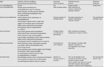
8.3 Discussion: A revised model and theory ... 249
8.3.1 The model of creative destruction of place in an HCD ... 252
8.3.2 Stage one: Early conservation... 252
8.3.4 Stage three: Early place destruction ... 255
8.3.5 Stage four: Advanced place destruction ... 256
8.3.6 Stage five: Post destruction ... 257
8.3.7 The utility of this revised model ... 258
8.4 Summary and suggestions for future research ... 259
8.5 Final thoughts ... 261
Bibliography ... 262
Appendices ... 276
List of Tables
Table 2a: The revised model of creative destruction ... 68
Table 3a: Answers to demographic questions by rounded percent ... 95
Table 4a: “What one word would you use to describe your neighbourhood?” ... 107
Table 4b: Neighbourhood boundaries as identified by interviewee ... 115
Table 4c: Heritage alteration permit applications by year ... 118
Table 4d: Heritage alteration permit approvals by year ... 119
Table 4e: Heritage alteration permit approvals by type ... 121
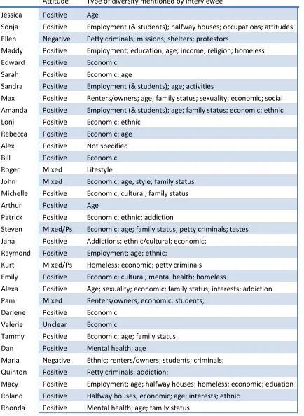
Table 5a: General attitude toward community mix and diversity ... 140
Table 5b: Change in number of rental units over time: The East Woodfield HCD ... 150
Table 5c: Change in number of rental units over time: The West Woodfield HCD ... 150
Table 5d: Survey results for question 11 ... 151
Table 5e: Survey results for question 12 ... 152
Table 5f: Unit changes by building, address and year ... 156
Table 6a: Architectural details mentioned in resident interviews ... 173
Table 6b: Change in number of businesses over time: The East Woodfield HCD ... 189
Table 6c: Change in number of businesses over time: The West Woodfield HCD ... 189
Table 6d: Demolition Permit Applications by year ... 190
List of Figures
Figure 1a: A map of the Woodfield Neighbourhood showing the West and East
Woodfield Heritage Conservation District Boundaries ... 1
Figure 1b: An article/photo that appeared in the London Free Press ... 2
Figure 1c: Heritage Conservation Districts in London, Ontario ... 4
Figure 1d: Heritage Alteration Permits and Heritage Designated Properties ... 5
Figure 1e: A map of the Woodfield Neighbourhood ... 13
Figure 1f: Hume Cronyn and his son Hume in the garden at Woodfield c 1915 ... 16
Figure 1g: A streetscape in Woodfield ... 17
Figure 1h: A streetscape in Woodfield ... 17
Figure 1i: First St. Andrews United Church, one of several historic churches in Woodfield ... 18
Figure 1j: Looking east and west from Maitland Street ... 23
Figure 1k: The policy framework for the creation of the East and West Woodfield HCDs ... 24
Figure 1l: The HCD Designation Process ... 29
Figure 1m: Some residents of Woodfield enjoying the Historic Woodfield Street Fair ... 32
Figure 2a: A model of creative destruction ... 62
Figure 3a: Map of the entire Woodfield neighbourhood ... 94
Figure 4b: “What one word would you use to describe your neighbourhood?” ... 105
Figure 4c: The friendly, lively, passionate people of Woodfield ... 107
Figure 4d: Unique street signage that indicates the East Woodfield HCD ... 110
Figure 4e: Overlaid maps of the various boundaries of Woodfield ... 114
Figure 4f: Unique street signage that indicates the East Woodfield HCD ... 122
Figure 4g: Boundaries of the East Woodfield Heritage Conservation District ... 123
Figure 4h: Overlaid maps of the various boundaries of Woodfield with the East Woodfield HCD boundaries superimposed ... 124
Figure 5a: Geared to income housing at 390 Princess Avenue ... 148
Figure 5b: A second, newer building constructed immediately west of the one above 148 Figure 5c: Context map. The red circle indicates the section of Princess Avenue ... 152
Figure 5d: Princess Avenue homes from Palace to William – north side ... 154
Figure 5e: Princess Avenue homes from William to Palace – south side ... 155
Figure 5f: Home with a new porch ... 157
Figure 5g: Home with a new porch and major interior/exterior renovations ... 158
Figure 5h: Duplex with new entrances, exterior renovations and major interior renovations ... 158
Figure 5i: Home with major exterior renovations, a large rear addition, significant upgrades and repairs and an interior gut and reno ... 159
Figure 6b: Part II of the Table of Contents for the East Woodfield HCD Plan ... 166
Figure 6c: Word cloud for the West Woodfield HCD Plan ... 167
Figure 6d: Decorative vinyl trim on gables on a newer suburban home as compared to original wood trim on a heritage home in Woodfield ... 174
Figure 7a: Woodfield Commons at 390 Princess Avenue ... 209
Figure 7b: A second, newer building ... 209
Figure 7c: The Waterloo Apartments in the West Woodfield HCD ... 212
Figure 7d: Woodfield Variety (closed) in the East Woodfield HCD ... 226
Figure 7e: A photo studio in the West Woodfield HCD ... 227
Figure 7f: A residential conversion in the East Woodfield HCD ... 227
Figure 8a: The creative destruction of place in an HCD ... 251
List of Appendices
Appendix A: Excerpt from The Ontario Heritage Toolkit. Heritage Conservation Districts:
A Guide to District Designation Under the Ontario Heritage Act ... 276
Appendix B: Interviewee references to insider researcher status ... 278
Appendix C: Interview Guide for resident interviews (2016-2017) ... 282
Appendix D: Recruitment Letter for resident interviews ... 286
Appendix E: Letter of Information and Consent for resident interviews ... 287
Appendix F: Interview Guide for City Planner interviews (2017) ... 290
Appendix G: Letter of Information and Consent for City Planner interviews ... 294
Appendix H: Coding shema for resident interviews ... 297
Chapter 1
1
INTRODUCTION AND COMMUNITY CONTEXT
1.1
Life in a Heritage Conservation District in London, Ontario
We have a problem in society if someone else is allowed to tell me what to do
with my property and house. These ‘Woodfield’ snots need to mind their own
and let this family live in an efficient, safe home. This is disgusting. (LawAbidingCitizen93, 2012, comment section)
In 2012, a demolition permit was requested for a small home in the Woodfield
neighbourhood in London, Ontario. The home sat on a street at the edge of two
adjoining Heritage Conservation Districts (HCDs); the West Woodfield HCD, designated
four years earlier in 2008, and the East Woodfield HCD, just across the street and
designated 20 years earlier in 1992 (Figure 1a).
Figure 1b: An article/photo that appeared in the London Free Press on Nov. 14, 2012. (Weber 2012)
The home (Figure 1b) had not been well maintained over the years and was not among
the largest or grandest homes in the neighbourhood. While many could see value in
neighbourhood, that this home would also be preserved caused some confusion. The
local newspaper called it a “street fight” (Weber 2012). A petition to support the
demolition gathered more than 60 signatures, while the London Advisory Committee on
Heritage and the local community association opposed the demolition.
Those who believed that the house should be demolished voiced support for the
comfort and safety of the homeowner, and the concerns of some nearby neighbours
about the visual state of the home. Those who opposed the demolition and called for
renovation were concerned with the protection of the intact historic streetscape, and
expressed a need to preserve the smaller homes in the neighbourhood as well as the
mansions. Eventually a design was submitted that incorporated much of the
streetscape presence of the home into a larger rebuild, approval was given, and the
story disappeared from the headlines.
This polarisation in the neighbourhood brought to bear an underlying tension that can
be found in many conversations about heritage conservation, both in the context of
individual buildings, and in the broader context of designated HCDs. The question of
why we preserve, for whom, and the impact of designation on the lives of district
residents is critically important, and of interest to research in geography. This
dissertation will examine this issue by uncovering the power dynamics that are created
and reinforced in the government texts that guide conservation and change in these
HCDs, and by identifying any explicit and implicit impacts of these texts on residential
sense of place.
Time is of the essence, for designated HCDs are rapidly expanding across Ontario. Since
the first HCD emerged in 1980, over 125 districts have been designated (Ministry of
Tourism Culture and Sport 2017). In London, there are currently seven designated HCDs
Figure 1c: Heritage Conservation Districts in London, Ontario. (Corporation of the City
of London 2016)
There has been a rapid expansion of designated districts, with the first appearing in
1992 (East Woodfield HCD), the second in 2001 (Bishop Hellmuth HCD), and five more in
the 11 years since 2006 (Figure 1d) with seven more on the books. Due to the nature of
the designation process in Ontario, that allows for unique plans to be created for each
individual HCD, specific guidelines, enforcement and levels of conservation vary across
these districts. There is a contradiction between the creation and enforcement of HCD
plans; although they are often initiated through ‘grass roots’ efforts, there is a shift on
designation to a top-down enforcement model. The HCD guidelines are interpreted by
who live in these districts. New boundaries are formed, along with the potential for a
new or renewed sense of place in the community. This new place may, over time, be
contested – as we have seen in the example above.
Figure 1d: Heritage Alteration Permits and Heritage Designated Properties. (Corporation of the City of London 2016)
A great deal of research into the designation of heritage properties has come from a
position of advocacy (Mason 2005). As a result, much of this work has focussed on
combatting myths about the economic costs of designation (e.g. Ijla, Ryberg Roesntraub
and Bowen 2011; Kovacs, Shipley, Snyder & Stupart 2008; Schaeffer & Millerick 1991;
Shipley 2000; Shipley, Jonas & Kovacs 2011; Shipley & Parsons 2006). Although the
evidence has grown regarding the numerous economic advantages of individual and
district designation, for many this alone does not prove their value. Even if such
LawAbidingCitizen93 reflects deeper concerns. For many the concept of living in a
heritage designated home is imbued with an inconceivable surrender of freedoms. As
occurred above, opponents of HCDs usually argue this point in terms of the associated
increases in regulations. This is misleading though, for all citizens are regulated
regarding changes to their “property and house” (LawAbidingCitizen93, 2012, comment
section). Such regulations are found in the by-laws and standards for everything from
the height of a porch rail to the width of a driveway, and impact all homes, not just
those designated as heritage properties. For some though, this added layer of
regulation is a bridge too far, regardless of benefits. Why then would anyone willingly
accept such constraints?
1.2
The economic and other advantages of designation
In Ontario, people who live in HCDs generally experience property value performance
that is equal to or better than in other areas of their city (Shipley 2000; Shipley, Jonas &
Kovacs 2011; Kovacs, Jonas-Galvin & Shipley 2015). This mirrors the experience in much
of North America, and is reflected throughout the literature, although outside of
academic circles misconceptions persist. In a 2007 article Robert Shipley reveals some
of his frustration with this in his title; The Real Impact of Heritage Designation: Too
Many Municipal Officials Have It Upside-Down. He begins by asking “What is the impact
of heritage designation?” and replies that it has “a very straightforward answer”
(Shipley 2007, p. 9). The author refers to a Brookings Institution publication which
reviewed 272 studies focused on the economic aspects of historic conservation. This
comprehensive review found that the clear majority of research is in line with Shipley’s
position that historic conservation exerts neutral to positive, but not negative effects on
economic value along numerous lines (Mason 2005). Mason opens his review with an
excellent summary of the state of the relationship between economics and historic
any way the effects are measured, be they direct or indirect, historic preservation tends
to yield significant benefits to the economy” (Mason 2005, executive summary).
There are many economic benefits to historic conservation, for both the individual
property owner and the larger community. These benefits accrue in different but
related ways through both the designation of individual properties and of larger
districts. As noted, for the individual these benefits are largely realized through higher
property values and increases in eventual property sale prices. The larger community
benefits as well, through higher tax revenues, City Council attention, job creation, and a
unique place that can serve to draw in customer and tourist dollars.
Authors have also considered the environmental benefits of conservation. Gilderbloom,
Hanka and Ambrosius (2009) found that while central city dwellers exhibited more
environmentally friendly behavior than their suburban counterparts, those living in
historic homes scored even higher. The authors note that historic renovation preserves
and reuses existing houses, conserves costs of construction, including material and
energy costs, and “encourages individuals to reside in neighbourhoods that naturally
foster more environmentally friendly behaviours” (Gilderbloom, Hanka & Ambrosius
2009, p.98). The environmental advantages of historic conservation produce local
benefits, and accrue far beyond as well. The buildings of our cities are the “largest and
most important recyclable resources we have” (Shipley 2007, p. 11). Shipley sees these
buildings as vessels of stored energy. Every brick, beam and nail required the burning of
fossil fuels. By holding onto them we avoid repeating these expenditures, and keep
massive amounts of debris out of the waste system (Shipley 2007).
Moreover, there are benefits for the individual who resides within the district, including
the enjoyment of a unique historic property, pride of ownership and satisfaction with
one’s neighbourhood. Shipley, Jonas and Kovacs (2011) conducted surveys in 32 of the
93 oldest Heritage Conservation Districts in Ontario. Among their findings the authors
level of satisfaction following designation than was encountered before (Shipley, Jonas
& Kovacs 2011).
When asked why they choose such a home, the historic home owner is likely to focus on
pride of ownership or the beauty of the neighbourhood. These are highly subjective
measures of course, but it is fair to say that relative rarity ensures unique home buying
opportunities in historic neighbourhoods. Heritage Conservation Districts conform to
ideas of good urbanism in modern planning. Many districts pre-date the automobile,
providing “pedestrian oriented, mass transit-friendly and mixed use” neighbourhoods,
adding to the unique qualities of the place (Ijla, Ryberg, Rosentraub & Bowen 2011, p.
279). The tendency for neighbourhoods that are worthy of designation to be close to
the core means that pedestrian opportunities can in fact spread well beyond the
borders of the district. Though not speaking of designated districts specifically, Jane
Jacobs reminds us that while walking in the “old city” we have the “safety of the streets
and the freedom of the city ... bringing with it a constant succession of eyes” (1961, p.
107).
Somewhat ironically given that they are the source of so much concern, one of the
advantages of Heritage Conservation Districts may be the standards and regulations
themselves. Standards can act to provide some comfort that the character of the
neighbourhood will not slip into decline (Shipley 2000) offering the homeowner
confidence that the atmosphere of their preferred neighbourhood, fundamental to
sense of place, will be there to enjoy for years.
Though less prominent in the literature, there may be neighbourhood-level societal
benefits as well. For example, one concern in any rarified area of a city is gentrification,
for as home prices increase, lower income earners are invariably pushed out. District
conservation holds the potential to preserve vintage homes of all sizes, and
well-enforced districts may have the side-effect of preserving smaller homes for local, lower
income homeowners. At the other extreme, immense preserved homes which are too
neighbourhoods for those who cannot afford even the smallest home. Coulson and
Leichenko for example, came to the “overriding conclusion that historical designation
does not lead to gentrification or any other kind of neighbourhood turnover” (Coulson &
Leichenko 2004, p. 1598). The authors found that over a decade after designation the
social mix in historic neighbourhoods stayed relatively the same (Coulson & Leichenko
2004). This finding is somewhat antithetical to much of the geographical literature
discussed in this chapter though, in relation to impacts on home prices. A decade is not
a particularly long time-frame in the grander scheme, and incidents such as those in the
example above show that the interpretation of HCD plans, and what is deemed worthy
of retention, remains subject to political pressures of the day. As outside interest in a
district increases, decisions made by City Councils will not always favour the lower
income home owner or renter. I will address this in greater detail in the chapters ahead.
1.3
The perceived disadvantages of designation
There are also disadvantages for those living in designated historically preserved
neighbourhoods. Added regulations do accompany designation, and should not be
disregarded. Schaeffer and Millerick contend that “regulations aimed at preserving a
neighbourhood can be too restrictive” (1991, p. 311). Any added bureaucracy can be a
nuisance, and Sharpe (2006) argues that these regulations are tied to lost opportunities
for the homeowner. Ashworth (2002) picks up this discussion from an economist’s
perspective. He argues that logically historic designation, with its associated constraints
through regulations of finish, use and design should not raise but rather lower property
values. The author provocatively points to the lack of published cases of failure, again
echoing the lean toward advocacy found in much of the literature.
For some, the perception of a home in a preserved neighbourhood may be akin to an
insect in amber, locked in time with no accommodation of current and future needs.
character” of the neighbourhood (Shipley & Snyder 2013, p. 309), for many residents
the restrictive nature of the guidelines may preclude or delay changes to their
neighbourhood that are needed or progressive, such as new businesses (e.g. a coffee
shop, a neighbourhood pub) or alternative forms of housing (e.g. high-density
apartments, modern condominiums). These themes will emerge again in the coming
chapters.
Finally, while there is a great deal of consensus about the straightforward relationship
between designation and property values, a deeper look reveals potential concerns here
as well. Attention must turn to the forces that are driving these increases in value.
Clearly there is more to this trend than simple designation. Coupled with heritage
designation are certain standards in both design and maintenance. It can be presumed
that higher standards in these areas will likely themselves positively impact the sale
price of a property, and further that its inclusion in a designated district will provide
some assurances against the decline of the neighbourhood at large (Shipley 2000).
While the enjoyment of a historic home may entice many owners, others may move into
such homes simply to gain the benefits of these standards, most notably in the district
context. These maintenance and design issues come with associated costs, and a fair
picture of property value increases should take these into account. In a related way, the
“substantial restrictions on how a property may be maintained and altered” or indeed
“demolished” (Coulson & Leichenko 2004, p. 1587) represent opportunity costs to the
owner, which are not reflected in simple measures of increased property values. The
story is more complex than sales prices alone may reveal.
Amusingly but not inaccurately, Schaeffer and Millerick speculated that “historic district
designation may serve a function similar to a designer label: it guarantees the quality of
the merchandise, reducing ... uncertainty” (1991, p. 311). As with any designer label, we
should consider the social costs of our investment. There is a potential human cost in
historic conservation, and a danger that some will be trodden under in the generally
effect of historic conservation on property values, but as property values increase in a
neighbourhood so too, generally, will rents, and poorer residents may be pushed out.
As many of the neighbourhoods most worthy of designation are found in the inner city,
those pushed out may be among the most vulnerable. As they move further from the
historic core in pursuit of lower rents, they may face higher costs of transportation, and
longer commutes. These problems are not new, and much of the related research into
gentrification has revealed these and other negative impacts of increased property
values on poorer residents (Coulson and Leichenko 2004). This potential will be further
explored ahead in this dissertation.
1.4
Research objectives
This dissertation is presented in the form of a single monograph, and follows a grounded
theory qualitative research approach. Grounded theory does not afford a traditional
research question a major role (e.g. Charmaz 2006; Flick 2007; Glaser and Strauss 1967).
The starting point is purposefully a more general observation or observations, knowing
that specific questions will shift and change along the way. Similarly, my own research
objectives arose more generally from years of personal first-hand observations of the
creation of, management of and indeed life in an HCD (see Chapter 3: Methods and
research design).
Still, no one embarks on a research project without a question, or questions, in mind.
To begin, my question was simply this: Does the designation of a Heritage Conservation
District (HCD) impact the sense of place experienced by the residents who live there,
and if so, do the HCD Plans support or challenge the physical and community aspects of
place that are valued by these residents? I did not know if this would be the case, and if
it was, why or how it would be the case.
Four key objectives informed this research:
1. To identify explicit and implicit references to sense of place, along with
the power dynamics that are created and reinforced in the government
texts that guide conservation and change in these districts. These
government texts include the Provincial Policy Statement, the Ontario
Heritage Act, the Ontario Heritage Toolkit and the specific East and West
Woodfield Heritage Conservation District Plans;
2. To reveal whether the HCD texts have had an impact, implicitly or
explicitly, on the experienced sense of place of the residents of the
Woodfield neighbourhood;
3. To produce a theoretical model of the power dynamics and the various
factors (including but not limited to power relationships, the government
texts themselves, the physical setting and community relationships) that
impact residential sense of place and the HCD place brand in the
neighbourhood;
4. To gain the perspective of City of London Planners, engaged in the
creation and enforcement of the HCD government texts, on my analysis.
This research has provided insights to inform future policy decisions, and indicates that
there is a need to revisit existing HCD plans to better accommodate the changing needs
of residents over time. Historically in London, no HCD plan has ever been revisited,
although the oldest one (East Woodfield) is now approaching three decades since it was
adopted. Completing these research objectives informed a theoretical model of the
changes that occur within an HCD, in relation to residential sense of place, over time.
These objectives guided the initial stages of research, and the grounded theory
To begin though, I will turn to a discussion of the neighbourhood of Woodfield, and the
unique attributes that make it worthy of study.
Figure 1e: A map of the Woodfield Neighbourhood. (by author)
1.5
Community context: An introduction to Woodfield
The neighbourhood of Woodfield is found in the core area of London, Ontario. This
neighbourhood sits to the northeast of London’s downtown, to the east of the shopping
district known as Richmond Row and to the west of the Old East Village neighbourhood
and shopping district. Woodfield is surrounded by other neighbourhoods, including the
Downtown and Midtown to the south, North Talbot to the west, Piccadilly to the north
and the Old East Village to the east. The boundaries of the neighbourhood, like most
neighbourhoods in London are for the most part set by the community itself. As such,
name itself vary. This will be explored ahead in Chapter 4: Place discourse: Sense of
place and place branding.
The boundaries that are recognised by both the City of London and the local community
association formed the starting point for this current research. These boundaries are
Richmond Street to the west, Queens Avenue to the south, Adelaide to the east and the
CPR tracks to the north (Figure 1e).
Woodfield’s position so near to the core of London is reflected in its historic connection
to the early growth of the city, and within these boundaries lie many important London
landmarks and places, including City Hall, Victoria Park, Centennial Hall and many of
London’s oldest residences and churches. According to Residential to the Core (Robbins
and de Blois 2007), a local history book:
When London was incorporated in 1840, the town plot’s original boundaries
were extended east to Adelaide and north to Huron. The Woodfield area
(formerly part of London Township) was now surveyed along with the rest of the
village’s new lands. An 1840-41 map shows little in the area that will become Woodfield with the exception of a large plot belonging to a Mr. Shofield and several blocks belonging to Rev. Benjamin Cronyn. (Robbins and de Blois 2007, p. 8)
The Cronyn family would go on to play an important part in the eventual naming of the
neighbourhood. Woodfield was not the original name of the area, which would have
simply been referred to as a part of London Township in the earliest days. Even when
the neighbourhood became more active in the 1960s, for many years the area was
simply referred to as Northeast Central London, a name taken by the local community
association in 1969. Outside of the community association and City Hall, it is unclear
how many people would have used even that name. The Woodfield name was adopted
formally in the 1980s, when several neighbours:
The name of Woodfield is rooted in a house, now demolished, that was owned at
various times by the Cronyn family. Originally called The Pines, Hume Cronyn and his
wife Amelia Labatt would eventually rename the house Woodfield as an homage to the
house in England in which they became engaged (Robbins and de Blois 2007, p. 16).
Their son (also called Hume) would go on to be one of the neighbourhood’s most
famous residents, a Hollywood actor who appeared in numerous movies and was
married to Jessica Tandy (Figure 1f). Although the home called Woodfield was itself
demolished in 1968, the neighbourhood of Woodfield houses a wealth of Victorian
architecture and largely intact historic streetscapes to this day.
When considering the heritage character of the area and the “historical themes and
built heritage that distinguish the larger community of Woodfield” (East Woodfield HCD
Plan 1992, p. 1-3) The East Woodfield Heritage Conservation District Plan draws
attention to the:
…considerable range and diversity in its architectural heritage of frame and brick residential development including the following styles and building practice: Vernacular, Gothic Revival, Italianate, High Victorian Gothic, Second Empire, Queen Anne, Prairie/Craftsman, Four Square (a sub-type of the Prairie style), Tudor Revival, and International. (East Woodfield HCD Plan 1992, p. 1-4)
Given this rich architectural heritage, many historical associations and a position so
close to the centre of the original township, it is not surprising that this neighbourhood
(Figures 1g, 1h and 1i) contains London’s first HCD, East Woodfield, as well as the newer
Figure 1g: A streetscape in Woodfield. (photo by author)
1.5.1
Woodfield: A tale of two Heritage Conservation Districts
1The neighbourhood of Woodfield uniquely contains the entirety of these two Heritage
Conservation Districts, with specific and different plans and guidelines created for each.
The earlier district, formed in 1992, is formally called the East Woodfield Heritage
Conservation District, while the second district, created in 2008 is called the West
Woodfield Heritage Conservation District. The details of the creation of these two
districts will be explained more fully ahead in this chapter. Outlines of the districts are
superimposed on the greater Woodfield neighbourhood in Figure 1e, above.
For the purposes of this research, Woodfield offers an opportunity to consider the
effects of heritage district designation on a single place under different policy
frameworks, and at different time scales. The 16-year gap between the creation of
these two districts brought with it differences in policy rhetoric and focus (discussed
ahead in this chapter). These differences, affecting two parts of a neighbourhood
immediately abutting one another, and in some places on either side of the same street,
allow for some interesting analytical opportunities.
The natural turnover of homes in Woodfield since 1992 also means that in the East
Woodfield HCD, most owners purchased their home in an existing HCD, complete with
street signage roughly indicating the district boundaries, and a registration on title as a
designated heritage property which they would be made aware of on purchase. In the
West Woodfield HCD however, many more home owners pre-date the district
designation in 2008, have no signs yet installed to indicate their place in an HCD, and
would have no need to consider their title until they choose to move. Complicating this
neighbourhood further, there are small remnant areas of the neighbourhood that fall
1 There is a third HCD that falls partially within the Woodfield neighbourhood, called the Downtown
outside of either of these HCD boundaries, excluded for reasons either political (e.g. an
owner of a block of properties who wished to not be included) or practical (e.g.
orphaned areas cut off from the boundaries when the West Woodfield HCD was
formed). However, as noted in the East Woodfield HCD Plan, the “historical themes and
built heritage” are consistent throughout “the larger community of Woodfield” (East
Woodfield HCD Plan 1992, p. 1-3).
Although this neighbourhood has retained much of its original architecture, change has
also been a constant in Woodfield. Even as the first HCD was being created, the authors
of the plan acknowledged that changes had already occurred, stating that:
The East Woodfield heritage conservation district exhibits a rich variety of architectural styles, building techniques and construction materials. Few, if any, of these buildings have survived as they were originally constructed. Repairs, changing domestic needs and new services all make their mark upon the fabric and form of the buildings. Some have resulted in the alteration of windows and doors, the recladding of frame structures or the construction of new additions. (East Woodfield HCD Plan 1992, section 4.1; emphasis added)
In the West Woodfield HCD, variety is expressed in a slightly different way. For
example, while the opening pages consider that “despite some redevelopment, the area
contains a high concentration of recognizable architectural styles and features that are
consistent with the styles and methods of construction associated within the era” (West
Woodfield HCD Plan 2008, p. 8.2.1), later in the text the authors indicate that:
throughout the WWHCD there are splendid examples of purpose built multi unit residential buildings. The original builders saw the advantage of offering a variety
of living unit sizes while maintaining a streetscape of compatible buildings of similar, large size. These original buildings typically were semi-detached houses, or row house constructions. (West Woodfield HCD Plan 2008, p. 8.2.5; emphasis added)
Attention to the importance of variety, found in the pages of both plans, foreshadow an
important theme that emerged in the resident interviews, and will be discussed ahead
texts that guide preservation and change within these two adjacent districts, and are
the focus of the first stage of the research presented here.
1.6
Policy context: the HCD government texts
Heritage Conservation District (HCD) Plans in Ontario are created and enforced in the
context of a multi-tiered framework of government texts. At the highest level, the
process is guided by government texts produced by the Province of Ontario, but their
aims are ultimately made manifest in the specific HCD guidelines and plans that are
designed, adopted and enforced at the municipal level. In this section I will review the
various government texts that guide the process of HCD designation in Ontario, namely
The Planning Act, The Ontario Heritage Act, The Provincial Policy Statement, The Ontario
Heritage Toolkit, and the specific HCD Plans created for each unique district.
1.6.1
Local context for the policy framework
In the context of HCDs, the relevant government texts establish and privilege what is to
be conserved (e.g. physical features, community features), who is to be consulted (e.g.
property owners, renters, Planners) and where the power lies (e.g. resident types,
resident obligations, resident oversight). To uncover how power relations are created
within the texts, and where they place this privilege in both explicit and implicit ways,
this thesis will consider the discourses within the texts themselves.
Winkel & Leipold (2016) describe discourse as an interpretive truth that uses a
dominant perception of truth to exert power. This is relevant when considering the
discourse of government texts (the relevant policies, guides, plans, and by-laws). These
texts by their nature define and quantify what makes one part of a city, or even one part
explicitly offer both a perception of truth, and a mechanism to exert power over the
reinforcement of that truth. This is most notable in the ultimate and specific HCD plans
designed at the municipal level.
While one aspect of such discourse is therefore interpretive, Winkel and Leipold (2016)
also consider that:
On the other hand, it has a process dimension. It is produced through agents and, consequently, constantly subject to change. This twofold character of a discourse as both structure and practice – and the resulting tension between stability (structures) and dynamic (practices) – is the essence of the policy discourse concept (Winkel and Leipold 2016, p. 112).
This thesis will explore the relationship between the two unique government texts (the
HCD plans) that guide preservation and change in the neighbourhood of Woodfield.
Woodfield is unusual in that while its two HCDs exist side by side, and as noted earlier
occasionally on either side of the same street, their relevant plans were created 16
years apart.
If one were to wander from one HCD to the next, they would be hard pressed to notice
a significant or abrupt change in architecture (Figure 1j) or visible socioeconomic cues.
The districts are similar in many ways, including the neighbourhood that they are found
in, their names, architectural styles, vintage, and proximity to the core. Conservation
and change within the East and West Woodfield HCDs however is governed in
accordance with plans established under different circumstances, with different
guidelines for heritage conservation and different potential impacts on residential sense
1.6.2
An overview of the HCD policy framework in Ontario
The focus of this research on two adjacent HCDs, within the same neighbourhood but
written 16 years apart adds a layer of complexity to the discursive comparison. While
similar, the policy framework and the relevant government texts varied in significant
ways, altering the context of each HCD-specific plan. An overview of the texts that
guided the process in each HCD is presented as Figure 1k, including specific version and
amendment years. In this section, each government text will be listed and briefly
explained in relation to the overall process of district designation.
1.6.2.1
The Planning Act
The Planning Act establishes rules for land use planning in the Province and considers
how land uses are controlled, and by whom. In part, the Planning Act indicates matters
of Provincial interest. Heritage conservation policy in Ontario originates in this section
of the Planning Act (Section 2) which states that:
The Minister, the council of a municipality, a local board, a planning board and the Municipal Board, in carrying out their responsibilities under this Act, shall
have regard to, among other matters, matters of provincial interest such as …
(d) the conservation of features of significant architectural, cultural, historical, archaeological or scientific interest (Government of Ontario 1990, Section 2d)
Importantly, Section 3.1 of the Act also authorises the Minister to issue Provincial Policy
Statements (PPSs) from time to time on matters relating to municipal planning if they
are deemed by the Minister to be of provincial interest. I will return to the PPS below.
1.6.2.2
The Ontario Heritage Act
The Ontario Heritage Act gives Ontario municipalities the powers needed to conserve
heritage in the province. It provides for heritage conservation of both individual
properties and districts (HCDs). Many aspects of heritage designation are identified in
the Act, including listings of individual buildings of heritage interest in a municipal
heritage register, the designation of these properties, the establishment of heritage
easements and the designation of archaeological significance. Part V of the Act allows
for the designation of HCDs:
The council of a municipality may undertake a study of any area of the
1.6.2.3
The Provincial Policy Statement
In accordance with The Planning Act, from time to time the Province of Ontario will
issue a Provincial Policy Statement (PPS). These statements provide policy direction on
matters deemed to be of Provincial interest by the Act. The latest of these statements
was issued in 2014, but the West Woodfield HCD Plan was established earlier, following
the 2005 PPS. The East Woodfield HCD Plan predates both statements.
Heritage interests are referred to repeatedly in the 2005 PPS. In Part IV for example,
the Statement links heritage resources to the “long-term prosperity and social
well-being of Ontarians” (Government of Ontario 2005, Part IV). The clearest guidance for
matters of cultural heritage is provided in Section 2: The Wise Use and Management of
Resources. Specifically, Section 2.6.1 states that “significant built heritage resources
and significant cultural heritage landscapes shall be conserved” (Government of Ontario
2005, Section 2.6.1; emphasis added).
The PPS is the first point of departure in the policy framework between the two
adjoining Woodfield HCDs. While the East Woodfield HCD Plan (1992) was established
after the Planning Act came into force and effect, it was written before the first PPS was
issued (in 1997), and does not find guidance in a PPS.
1.6.2.4
The Ontario Heritage Toolkit
The Ontario Heritage Toolkit (Government of Ontario 2006) is different from the other
guiding government texts presented here in that it serves primarily as a guide for
“municipal staff, heritage committee members and heritage community groups”
(Government of Ontario 2006, p. 1) who are considering developing an HCD plan. The
guide provides an overview of the concept and practice of HCD designation, the
benefits, legislation and practical advice on the preparation of a plan and guidelines, and
The toolkit also addresses more thoroughly the criteria by which potential HCDs should
be considered, answering the fundamental questions of what makes an HCD unique,
and how municipalities may identify them:
Municipalities and communities choose to designate HCDs to conserve their heritage character. The cultural heritage value of individual sites can be expressed in terms of their design or physical, historical or associative or contextual values. The values that contribute to the character of heritage conservation districts may be expressed more broadly as natural, historic, aesthetic, architectural, scenic, scientific, cultural, social or spiritual values.
(Government of Ontario 2006, p. 10)
Although the toolkit acknowledges that each district will be created for unique reasons,
many have common characteristics, including:
• A concentration of heritage buildings, sites, structures; designed landscapes, natural landscapes that are linked by aesthetic, historical and socio-cultural contexts or use;
• A framework of structured elements including major natural features such as topography, land form, landscapes, water courses and built form such as pathways and street patterns, landmarks, nodes or intersections, approaches and edges;
• A sense of visual coherence through the use of such elements as building scale, mass, height, material, proportion, colour, etc. that convey a distinct sense of time or place;
• A distinctiveness which enables districts to be recognised and distinguishable from their surroundings or from neighbouring areas (Government of Ontario 2006, p. 9).
As such, while districts will vary, often dramatically, in their overall make-up and specific
features, there are consistencies across the province (see also Appendix A).
Ultimately the government text that directly guides conservation and change within a
specific, local London HCD is the Heritage Conservation District Plan. This is the ultimate
product of the HCD policy framework, and while each City produces it in unique ways
guide and directly influence planning decisions within the district. The process of
designation is laid out in Figure 1l.
1.6.2.5
The HCD designation process
While there are minor differences in the process as it applied to the creation of the East
and West Woodfield plans, overall the process has remained relatively unchanged. The
process begins with a request or proposal to dedicate the district. This may come from
anyone in the community (e.g. a neighbour, a local historian or historic society, Planning
staff, a City Councillor). In practice in London, and certainly in the two HCDs discussed
here, this request has come from residents living near or within the proposed districts,
in coordination with their local community association.
City Planning staff, including the Heritage Planner, become involved at this stage and
offer guidance to the community as they consider preliminary boundaries and reasons
for designation. If the preliminary boundaries and reasons for designation are deemed
sufficient, staff puts forward a recommendation to City Council to authorise a Heritage
Conservation District Study. If City Council votes yes, the Municipal Heritage Committee
is consulted. In London, this advisory committee is referred to as the LACH or London
Advisory Committee on Heritage (formerly the LACAC or London Architectural
In London, a consulting firm is usually engaged by the City to conduct the study
(Unterman McPhail Cuming Associates for the East Woodfield HCD; Stantec for the West
Woodfield HCD). A limited number of local residents and other interested citizens from
outside of the neighbourhood are given an opportunity to sit on the steering
committee, which works with the consultants throughout the process. They consider
the character of the study area, with a focus on physical structures, buildings and other
features, along with the historic context. They recommend boundaries and objectives
for the HCD. The findings and recommendations arising from the study are then
presented to City Council, and a decision is made as to whether to proceed with
designation. If City Council again votes yes, the plan and guidelines are prepared,
presented to the public, and a final vote at City Council is made as to whether or not to
designate the area. By-laws are passed and made public, and if there are no objections
(to the Ontario Municipal Board) then the plan and guidelines are adopted, and the
plans come into effect.
It is important to note that although some residents are involved in the initial
recommendations and may join the steering committee as the plan is developed,
following designation there is no official role for those living in these districts in the
interpretation and enforcement of the plans. In London, this power transfers to City
Planners and Heritage Planners, the London Advisory Committee on Heritage and
ultimately City Council. Any ongoing citizen involvement is less formal (e.g. lobbying
City Councillors, speaking at public meetings) or adversarial (e.g. complaints in the press,
Ontario Municipal Board challenges). While the community is actively engaged in the
creation of the plans, ongoing interpretation and enforcement can vary year to year and
City Council to City Council, and the residents are left with no formal control over this
interpretation. This loss of influence over a process initiated by the residents
themselves is one way in which these texts effect the placement of power in the HCD
1.7
Thesis outline
This thesis is written as a single manuscript, and is the result of a grounded theory
qualitative research approach. It is comprised of 8 chapters. This first chapter has
introduced this research, provided some background, and explained the community and
policy context for the thesis, including the reasons for the selection of Woodfield as the
neighbourhood of interest.
Chapter 2 provides a review of the relevant literature. This chapter begins with an
overview of sense of place and place branding. A review of the concepts of
gentrification and community identities is also provided, considering their role in HCD
place making, and the potential for place destruction. This chapter concludes with an
introduction to the model of creative destruction put forward by Mitchell (e.g. 1998,
2000, 2001, 2009), advanced by others, and revised in the final chapter of this
dissertation.
Chapter 3 explains my research methods and design. A review of grounded theory, and
how this qualitative approach was applied to the research precedes a detailed
discussion of the discourse analysis of relevant government texts, depth interviews with
HCD residents (including participant recruitment), and depth interviews with City of
London Planners engaged in the creation and enforcement of the HCD government
texts. I also consider the complexities of interviewing for sense of place and strategies
for doing so effectively. As I have lived and worked in Woodfield for many years, this
chapter also provides the reader with my position statement, and considers the
researcher as instrument. The chapter ends with a reflection on the impacts that my
dual role as insider researcher and resident may have had on the manuscript.
Chapters 4, 5 and 6 summarise the findings from my discourse analysis of the
government texts that guide conservation and change within the HCDs, and provide an
analysis of the depth interviews with HCD residents (Figure 1m). Chapter 4 follows the
the community aspects of place, and Chapter 6 turns to the physical aspects of place. In
all three chapters, data from the discourse analysis of government texts and depth
interviews is presented alongside other data sources, to provide local indicators of place
destruction in support of these findings.
Figure 1m: Some residents of Woodfield enjoying the Historic Woodfield Street Fair. (Woodfield Community Association photo archive with art effect by author)
Chapter 7 summarises these findings and presents conclusions. Suggestions for policy
changes and future research are also provided, with input from depth interviews with
three City of London Planners, who have been engaged in the creation and enforcement
of these districts. At this stage in the research, a grounded theory approach led to the
Finally, Chapter 8 puts forward this revised theory: the creative destruction of place in a
Heritage Conservation District. This theory builds on the work of Mitchell and others.
References, appendices and a curriculum vitae round out the manuscript.
In this thesis, I move beyond the economic considerations of district conservation and
the level of satisfaction experienced by those living in these HCDs. Through a discourse
analysis of the relevant government texts, depth interviews with HCD residents, and
triangulation with other data sources I map the sense of place experienced by residents,
and consider how this is created, perpetuated and challenged. I draw linkages between
the government texts that guide conservation and change in these districts, and the
expressed attachment to community and the physical aspects of place, as reported by
residents. Through a grounded theory approach, I let the data speak for itself wherever
Chapter 2
2
PLACE, GENTRIFICATION, COMMUNITY IDENTITIES
AND CREATIVE DESTUCTION
2.1
Introduction
Sense of place is mentioned prominently and explicitly in the highest levels of the policy
framework that guides the creation and enforcement of Heritage Conservation Districts
(HCDs) in Ontario. It will be shown that this concept, however, is poorly defined in
these texts, providing little guidance for the designation of specific HCDs. While the
maintenance of sense of place is heralded as a benefit of designation (The Ontario
Heritage Toolkit 2006), there are no specific guidelines provided for how to achieve this.
As a result, this language is generally absent in the local HCD plans. This is important,
because as de Wit has argued:
Place meanings, and sense of place in particular, have a profound influence on
residents’ sense of community and personal identity. Events, policies, or
decisions that impact that intangible sense of place can result in very tangible political, social, and economic ramifications. (de Wit 2013, p. 139)
Sense of place is a particularly complicated concept in the context of an historic
neighbourhood. By nature, it is shaped by connections to a long-standing and contested
physical place: a place imbued with historic meaning that appeals to those beyond the
boundaries of the neighbourhood itself, and a place that means different things to
different residents. Generally found in core areas, the parallel opportunities for
conservation and change are constantly at odds.
The process of designating an historic core neighbourhood as an HCD only complicates
this further, adding new regulations and guidance that may enhance or challenge the
existing residential sense of place. Residential sense of place has been defined by Billig