Available Online atwww.ijcsmc.com
International Journal of Computer Science and Mobile Computing
A Monthly Journal of Computer Science and Information Technology
ISSN 2320–088X
IJCSMC, Vol. 4, Issue. 7, July 2015, pg.55 – 60
RESEARCH ARTICLE
DESIGN AND IMPLEMENTATION OF REAL
TIME VEHICLE TRACKING SYSTEM
CH. Vinay Kumar M.Tech(Embedded systems) [email protected]
JITS, Knr
M. Rama Krishna Associate professor [email protected]
JITS, Knr
Abstract: The Rapid growth of technology and infrastructure has made our lives easier. The advantage of technology has also increased the traffic hazards and the road accident take place frequently which causes huge loss of life and property because of the poor emergency facilities. Our project will provide an optimum solution to this draw back. An integrated Cell phone GPS-GSM system is proposed to track vehicles using Google Earth application develop in android application for mobile system. The remote module has a Bluetooth mounted on the moving vehicle with attached accident detecting sensor to identify if accidents happens. Here Bluetooth will be the medium of communication with the user mobile for activating the GPS position of the cell phone. In this case cell phone will get activated its application and track the current position of the vehicle and send it to the remote located predefined phone for tracking the real time position of the situation. After data processing, Google Earth application can be used to view the current location and status of each vehicle. (To detect the real time localization of the vehicle using Bluetooth technology with GPS locator in cell phone using android application.)
Keywords: Bluetooth system, cell phone GPS-GSM technology, android application, accident place locator.
I. INTRODUCTION
The ability to accurately detect a vehicle‟s location and its status is the main goal of automobile trajectory monitoring systems.& also The high demand of automobiles has also increased the traffic hazards and the road accidents. This is because of the lack of best emergency facilities available in our country This design is a system which can detect accidents in significantly less time and sends the basic information to first aid center within a few seconds covering geographical coordinates, the time and angle in which a vehicle accident had occurred. This alert message is sent to the rescue team in a short time, which will help in saving the valuable lives. These systems are implemented using several hybrid techniques that include: wireless communication, geographical positioning and embedded applications.
1.1 Automatic Accident Detection and Reporting System using GSM and GPS:
automatically detecting the accident and a hardware tracking device based on GSM/GPS technology informing at the occurrence of accident with sufficient details like exact location and time at which accident happened. This project will establish a communication between the control station and the unit installed in vehicles. Vehicles will have GPS/GSM enabled tracking modules and will be tracked in real time using cellular networks. The software embedded in the microcontroller will control the various operations of the device by monitoring waveform from the vibration sensor. In case of accident the device will send an alert message along with location data from GPS module to control station using GSM network. It is a comprehensive and effective solution to the poor rescue response in case of accident. The accident reporting can automatically find a traffic accident, search for the spot and then send the basic information to the rescue agency covering geographical coordinates and the time and circumstances in which a traffic accident took place. At the server end, a control function will extract relevant data and store it in a database, to which accident information from prototypes will be polled in real time. Our system combines advanced hardware design and sophisticated control technology into a compact, reliable package.
The vehicle tracking systems are designed to assist
corporations with large number of automobiles and several usage purposes. A Fleet management system can minimize the cost and effort of employees to finish road assignments within a minimal time. Besides, assignments can be scheduled in advanced based on current automobiles location. Therefore, central fleet management is essential to large enterprises to meet the varying requirements of customers and to improve the productivity [1]. So taking in action all these things we are going to design and develop a machine, which will track the real time location of the vehicle using blue tooth technology with the help of an android base mobile phones. The ability to accurately detect a vehicle‟s location and its status is the main goal of automobile trajectory monitoring systems. These systems are implemented using several hybrid techniques that include: wireless communication, geographical positioning and embedded applications. The vehicle tracking systems are designed to assist corporations with large number of automobiles and several usage purposes. This system can minimize the cost and effort of employees to finish road assignments within a minimal time. So taking in action all these things we are going to design and develop a machine, which will track the real time location of the vehicle using blue tooth technology with the help of an android base mobile phones. The main goals of this project is to design and develop an economical model, which requires less power with less complex in structure, easy to implement. An additional setting could be implemented to interface the system to the car‟s alarm to alert the owner on his cell phone if the alarm is set off. The automobile‟s airbag system can also be wired to this system to report severe accidents to immediately alert the police and ambulance service with the location of the accident
II. LITERATURE REVIEW
Traditionally, navigation systems have been large, expensive, and used only in aviaion or military applications. However, the presence of the GPS and the recent proliferation of small low-cost motion sensors have made possible navigation systems that are small and inexpensive enough to be used in consumer products. Commercial consumer-grade navigation systems are, in fact, readily found today in Japan, Europe, and the United States, with one application being automobile navigation systems.
the use of cutting edge technologies to served the target of vehicle tracking. These technology include Communication remote Control, GPS, GIS server systems and others.
III. ARCHITECTURE OF GPS TRACKING AND GSM MODULES
In this paper, we describe the design of a proposed tracking system in this paper is designed to track and monitor automobiles‟ status that are used by certain party for particular purposes, this system is an integration of several modern embedded and communication technologies. To provide location and time information anywhere on earth, Global Positioning System (GPS) is commonly used as a space-based global navigation satellite system. The location information provided by us GPS systems can be visualized using Google Earth technology. In wireless data transporting, Global System of Mobile (GSM) and Short Message Service (SMS) technology is a common feature with all mobile network service providers. Utilization of SMS technology has become popular because it is an inexpensive, convenient and accessible way of transferring and receiving data with high reliability. As shown in figure (1), the proposed system consists of: in-vehicle GPS receiver, GSM modems (stationary and in-vehicle), and embedded controller. The users of this application can monitor the location graphically on Google Earth; they also can view other relevant information of each automobile in the fleet
Figure 1. The block diagram of GPS tracking system
The implemented tracking system can be used to monitor various parameters related to safety, emergency services and engine stall. The paper shows an implementation of several modern technologies to achieve a desirable goal of fleet monitoring and management. The system has two main modules, as shown in figure (1). The first module is the tracking device which is attached to the moving automobile. This module composes of a GPS receiver, Microcontroller and GSM Modem The GPS Receiver receives the location information from satellites in the form of latitude and longitude real time reading. The Microcontroller has three main tasks to read certain engine parameters from automobile data port (OBD-II), to processes the GPS information to extract desired values and to transmit this data to the server using GSM modem by SMS. The chosen engine parameters are Revaluation per minute, engine coolant temperature, vehicle speed. The second module consists of a recipient GSM modem and workstation PC. The modem receive the SMS that includes GPS coordinates and engine parameters. This text is processed using a Visual Basic program to obtain the numeric parameters, which to be saved as a Microsoft Office Excel file The received reading of the GPS is further corrected by Kalman filter technology. To transfer this information to Google Earth, the Excel file is converted to KML, Keyhole Markup Language format. Google Earth interprets KML file and shows automobile‟s location and engine parameters on the map. The system‟s efficiency is depend on the sufficiency of the used communication network.
IV. RESULT
Successfully completed Thesis on Tracking Down Vehicle and Locking it remotely using GPS and GSM technologies.
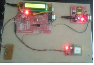
The overall developed circuit looks as in the following figure:
Fig 4.1 Picture of VTS kit
The above circuit works mainly by receiving messages from a mobile phone. There are three messages/commands by which we can track and control the vehicle. They are,
i) TRACK
ii) LOCKD
iii) NLOCK
i) TRACK: Initiates the GPS modem and receives the Latitude and Longitude positionand this information will be sent to the mobile from which it received the message.
ii) LOCKD: When this message is sent, then the Microcontroller initiates the motor which is located in between the passage of fuel to stop and which in turn stops the vehicle.
iii) NLOCK: This command makes the motor to start again so that the vehicle startsrunning.
This project can further be crafted by restricting the usage of limited mobile numbers to get access to the device. This can be made by altering the program.
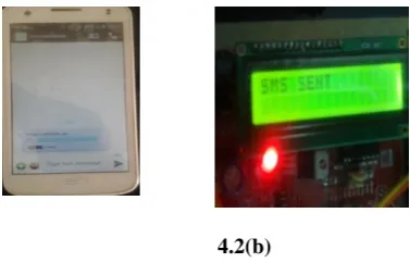
The message which is sent to the mobile will be as shown in the following figure.
4.2(b)
Fig 4.2 (a).5.2(b) Message received from the VTS kit
With the knowledge in Electronics and Communications we have successfully completed our project with perfect results.
V. CONCLUSION
The project titled “tracing down the vehicle using GSM and satellite communication” is a model for vehicle tracking unit with the help of gps receivers and GSM modem. Vehicle Tracking System resulted in improving overall productivity with better fleet management that in turn offers better return on your investments. Better scheduling or route planning can enable you handle larger jobs loads within a particular time. Vehicle tracking both in case of personal as well as business purpose improves safety and security, communication medium, performance monitoring and increases productivity. So in the coming year, it is going to play a major role in our day-to-day living.
We have completed the project as per the requirements of our project. Finally the aim of the project i.e. to trace the vehicle is successfully achieved.
VI. FUTURE SCOPE
We can use the EEPROM to store the previous Navigating positions up to 256 locations and we can navigate up to N number of locations by increasing its memory.
We can reduce the size of the kit by using GPS+GSM on the same module.
We can increase the accuracy up to 3m by increasing the cost of the GPS receivers.
We can use our kit for detection of bomb by connecting to the bomb detector.
With the help of high sensitivity vibration sensors we can detect the accident.
Whenever vehicle unexpectedly had an accident on the road with help of vibration sensor we can detect
the accident and we can send the location to the owner, hospital and police.
We can use our kit to assist the traffic. By keeping the kits in the entire vehicles and by knowing the locations of all the vehicles.
If anybody steals our car we can easily find our car around the globe. By keeping vehicle positioning
vehicle on the vehicle.
REFERENCES
[1] T. Krishna Kishore, T.Sasi Vardhan, N.Lakshmi Narayana, „Automobile Tracking Using a Reliable Embedded Data Acquisition Sysytem With GPS and GSM‟, International Journal of Computer Science and Network Security, VOL.10 No.2, 286-291, 2010.
[2] M. A. Al-Taee, O. B. Khader, and N. A. Al-Saber,“ Remote monitoring of Automobile diagnostics and location using a smart box with Global Positioning System and General Radio Service,” in Proc. IEEE/ACS AICCSA, May 13–16, 2007, pp. 385–388
[4] Fan, X., W. Xu, H. Chen, and L. Liu, “CCSMOMS:A Composite Communication Scheme for Mobile Object Management System”, 20th International Conference on Advanced Information Networking and Applications, Volume 2, Issue 18-20, April 2006, pp. 235–239.
[5] Hsiao, W.C.M., and S.K.J. Chang, “The Optimal Location Update Strategy of Cellular Network Based Traffic Information System”, Intelligent Transportation Systems Conference, 2006.
[6] Ioan Lita, Ion Bogdan Cioc and Daniel Alexandru Visan, “A New Approach of Automobile Localization System Using GPS and GSM/GPRS Transmission,” Proc. ISSE ' 06, pp. 115-119, 2006.
[7] Wen Leng and Chuntao Shi, “The GPRS-based location system for the long-distance freight”, ChinaCom '06, pp1-5, Oct.2006.
[8] Hapsari, A.T., E.Y. Syamsudin, and I. Pramana, “Design of Automobile Position Tracking System Using Short Message Services And Its Implementation on FPGA”, Proceedings of the Conference on Asia South Pacific Design Automation, Shanghai, China, 2005.
[9] C. E. Lin, C. C. Li, S. H. Yang, S. H. Lin; C. Y. Lin, “Development of On-Line Diagnostics and Real Time Early Warning System for Automobiles,” in Proc. IEEE Sensors for Industry Conference, Houston, 2005, pp. 45-51.
[10] C. E. Lin, C.-W. Hsu, Y.-S. Lee, and C.C.Li, “Verification of unmanned air Automobile flight control and surveillance using mobile communication,”J. Aerosp. Comput. Inf. Commun., vol. 1, no. 4, pp. 189–197, Apr. 2004
[11] J. E.Marca, C. R. Rindt,M.Mcnally, and S. T. Doherty, “A GPS enhanced in-Automobile extensible data collection unit,” Inst. Transp. Studies, Univ.California, Irvine, CA, Uci-Its- As-Wp-00-9, 2000.