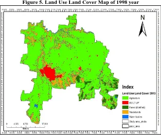
Change Detection in Land use / Land cover in Akola Taluka Using Remote Sensing and GIS Technique
Full text
Figure


Related documents
CSEIT184505 | Published 14 April 2018 | March April 2018 [ (4 ) 5 41 49] International Conference on New Horizons in Science Engineering Technology (NHSET 2018) International Journal
The reference-hypernetted chain integral equation, incorporating a spherically symmetric approximation for the bridge function Bo(12), has been numerically solved for a
Quantum chemical parameters presented in table-3 confirmed good inhibition performance of active constituents of EE Li L as corrosion inhibitor and also confirmed strong
Summary of joint analysis of variance for plant height (PH, cm), average boll weight (ABW, g), lint percentage (LP, %), seed cotton yield (SCY, kg/ha), fiber length (FL, mm),
The present paper has argued that excessive general impairment of gene expression can be expected to manifest as abnormality of behaviour and appearance, with certain
In this report we compare the expression of the mature retinal markers CRX, recoverin, Tuj1, PKCa and MAP2 in the most commonly studied Y79 and WERIRB27 human retinoblastoma
The results reveal that CNT-CdSe composite exhibit excellent photocatalytic activity for degradation of MB solution under visible- light irradiation.. Authors
Wu Z, Dong F, Zhao W, Wang H, Liu Y, Guan B: The fabrication and characterization of novel carbon doped TiO 2 nanotubes, nanowires and nanorods with high visible light