ISSN (Print) : 2320 – 3765 ISSN (Online): 2278 – 8875
I
nternational
J
ournal of
A
dvanced
R
esearch in
E
lectrical,
E
lectronics and
I
nstrumentation
E
ngineering
(An ISO 3297: 2007 Certified Organization)
Website: www.ijareeie.com
Vol. 6, Issue 2, February 2017
Water Level Meter for Alerting Population
about Floods by Using AT MEGA 2560
1
Tayyabunnissa Begum, 2 Chilka Naresh Kumar, 3 Gundam Ashok, 4Susheel Vishwakarma,5 Basani
Prashanth 1
Assistant Professor, Dept. of ECE, Lords Institute of Engineering and Technology, Hyderabad, Telangana, India 2,3,4,5
UG Students, Dept. of ECE, Lords Institute of Engineering and Technology, Hyderabad, Telangana, India.
ABSTRACT:This micro-model is performed on the basis of a programmable electronic printed circuit AT MEGA
2560, an electronic circuit connected to electrical resistances that are located at a specific height, within a water container: when the water level rises and reaches the resistors, varies the impedance, the information from water level sensor is transmitted via Wi-Fi to a laptop, then this information is also seen in smartphones, where users can see the water level in rivers. Finally, the micro-model is tested by experimental tests under a controlled environment and satisfactory results are obtained. The main aim of this project is to design a system which will monitor and control the water level in the dams and also intimates the concerned authority when the water level exceeds the limit.
KEYWORDS:Flood Observatory System, arduino, early warning system, portable water levels
I. INTRODUCTION
ISSN (Print) : 2320 – 3765 ISSN (Online): 2278 – 8875
I
nternational
J
ournal of
A
dvanced
R
esearch in
E
lectrical,
E
lectronics and
I
nstrumentation
E
ngineering
(An ISO 3297: 2007 Certified Organization)
Website: www.ijareeie.com
Vol. 6, Issue 2, February 2017
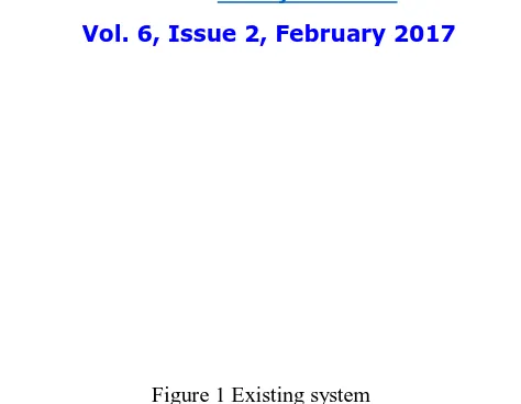
Figure 1 Existing system
II. RELATED WORK
In most places, rainfall is likely to occur irregularly and in widely differentamounts from one time to another. As a result, the streams which carry the surface runofffluctuate greatly in the amount of water they carry. Thus, floods can be expected to occurat intervals as a normal part of the cycle in [4].
In [5] the author stated that floods are the second-most widespread naturaldisaster on Earth. It happens when water overflows or soaks land that is normally dry.There are few places on Earth where people don’t need to be concerned about flooding.Generally, floods take hours or even days to develop, giving residents time to prepareor evacuate. Sometimes, floods develop quickly and with little warning. Flooding may result from the volume of water within a body of water, such asa river or lake, which overflows or breaks levees, with the result that some of the waterescapes its usual boundaries, or may be due to accumulation of rainwater on saturatedground in an area flood. It can also arise from abnormal heavy precipitation, dam failures,rapid snow melts, river blockages in [6].Impacts of Flood Events. Floods are among the most dramatic forms ofinteraction between man and its environment. They are always associated with heavyloses of life and property, misery hardship disease and at times, famine. There are twomain causes of flood which are natural and man-made.
Some examples of natural causes are heavy rainfall and overflowing of riverbanks which usually results to perennial flooding. Also, heavy rainfall accompanied byflooding cannot only cause tremendous damage to buildings and homes, but also killwoody and herbaceous plants in [7].
In [8] the author pronounced that significant amount of topsoil were removed from a largearea of farm land. Whereas some parts of the landscape have lost significant amounts oftopsoil both due to sheet erosion as rain falls on wet soils and heavy flooding. However,the removal of topsoil is always a loss to agricultural productivity for topsoil is that partof the soil horizon having higher level of organic matter and nutrients which generally has better structure. Some effects of flood caused by natural causes depend on rainfallduration, heights of water level, topography, and use of flood plains.The most significant impact of flooding arises from man-made causes likeurbanization because it involves deforestation, land use changes, temperaturemodification of soil’s physical properties and structures and the exposure of bare soilsurfaces especially of construction sites all of which bring about changes in themorphological and hydrological state of water in [9].
ISSN (Print) : 2320 – 3765 ISSN (Online): 2278 – 8875
I
nternational
J
ournal of
A
dvanced
R
esearch in
E
lectrical,
E
lectronics and
I
nstrumentation
E
ngineering
(An ISO 3297: 2007 Certified Organization)
Website: www.ijareeie.com
Vol. 6, Issue 2, February 2017
In [12] the author stated that sirens are designed to provide a very rapid alert topotentially threatened populations. They
are currently the only reliable means of alertingoutdoor populations. Some sirens are used in making an effective FWS.Furthermore, a local flood warning system helps in increasing lead time forwatches and warnings at locations subject to flood risk. The information can be used topredict whether a flood is about to occur, when it will arrive, and how severe it will be. Organizations and individuals are given notice by the system so they can protectthemselves and their property.
Floods impact on both individuals and communities and have social, economic,and environmental punishment. The consequences of floods, both negative and positive,vary greatly depending on the location and scope of flooding, and the susceptibility andvalue of the natural and constructed environments they affect. Floods can also traumatizevictims and their families for long periods of time. The loss of loved ones has deepimpacts, especially on children. Displacement from one's home, loss of property anddisruption to business and social affairs can cause continuing stress. For some people thepsychological impacts can be long lasting.
III. SYSTEM ARCHITECTURE
In this proposed system we are using Arduino mega microcontroller and GSM for giving information to others and we are using Ethernet.We note that the thresholds are defined by the user based on prior knowledge and experiencewith the floods. Different thresholds are defined for units positioned at different places of theflooding area. Now, as the water levels increase the air in the gap compresses resulting in achange in the pressure. The pressure sensor is placed inside facing the trapped air, senses thepressure of the air and converts it into voltage. Since the voltage output of the sensor is inanalogue an Analogue to Digital conversion is required for the calculation which is done bythe microprocessor. Once the water level rises to the threshold level the system will sendemergency SMS to all pre-determined participants and activate the siren. SMS messages inthe Fiji Islands will also go to authorities such as the Fiji National Disaster ManagementCommittee (DISMAC). Upon receiving the txt message DISMAC can quickly open up theemigration centers and carry out the necessary steps to facilitate the emigrationprocess alertother authorities (police, military, fire department, etc.) and secure properties. The overallflowchart is given is Figure 3.
ISSN (Print) : 2320 – 3765 ISSN (Online): 2278 – 8875
I
nternational
J
ournal of
A
dvanced
R
esearch in
E
lectrical,
E
lectronics and
I
nstrumentation
E
ngineering
(An ISO 3297: 2007 Certified Organization)
Website: www.ijareeie.com
Vol. 6, Issue 2, February 2017
Figure 3: Flowchart of the design of the flood level monitoring system.
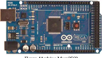
Arduino Mega2560
The Arduino Mega2560 has a number of facilities for communicating with a computer,another Arduino, or other microcontrollers. The ATmega2560 provides four hardware UARTsfor TTL (5V) serial communication. An ATmega8U2 on the board channels one of theseover USB and provides a virtual com port to software on the computer (Windows machineswill need a .inf file, but OSX and Linux machines will recognize the board as a COM portautomatically. The Arduino software includes a serial monitor which allows simple textualdata to be sent to and from the board. The RX and TX LEDs on the board will flash whendata is being transmitted via the ATmega8U2 chip and USB connection to the computer (butnot for serial communication on pins 0 and 1).
Figure 4Arduino Mega2560
WL400 water level pressure sensor
It is high accurate and reliability. It is completely submersible sensors and cable. Its multiple ranges available from 3’ to 250’. It is a dynamic temperature compensation system. It is not affected by foam wind or rain.
Liquid crystal display (LCD)
LCD (Liquid Crystal Display) is a viewer modulewhich is widely used because it simple looks. The mostwidely LCD module used today is M1632 LCD becausethe price is quite cheap. M1632 LCD display is an LCD
ISSN (Print) : 2320 – 3765 ISSN (Online): 2278 – 8875
I
nternational
J
ournal of
A
dvanced
R
esearch in
E
lectrical,
E
lectronics and
I
nstrumentation
E
ngineering
(An ISO 3297: 2007 Certified Organization)
Website: www.ijareeie.com
Vol. 6, Issue 2, February 2017
Figure 5. LCD with example display of data.
GSM Module
A GSM Module is basically a GSM Modem (like SIM 900) connected to a PCB with different types of output taken from the board – say TTL Output (for Arduino, 8051 and other microcontrollers) and RS232 Output to interface directly with a PC (personal computer). The board will also have pins or provisions to attach mic and speaker, to take out +5V or other values of power and ground connections. These types of provisions vary with different modules.Lots of varieties of GSM modem and GSM Modules are available in the market to choose from. For our project of connecting a GSM modem or module to arduino and hence send and receive sms using arduino – it’s always good to choose an arduino compatible GSM Module – that is a GSM module with TTL Output provisions.
Figure 6GSM Module
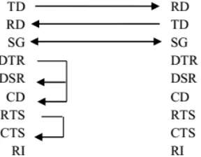
The Microcontroller and Mobile Phone
Due to the highly static damage nature of the ATmega2560microcontroller, theprototype board has been implemented. The prototype board has a MAX232 chip on board,which is a RS232 transmitter and receiver and this allows the microcontroller, to communicatewith mobile phone serially. A mobile phone is interfaced with microprocessor to sendemergency SMS. The microcontroller, as well as the mobile phone are both Data Circuit
Equipment (DCE) devices; therefore for serial interface, transmitter pin of microcontroller, isconnected to receiver pin and receiver pin of microcontroller, to transmitter pin of phone [9],as shown in Figure 7.
ISSN (Print) : 2320 – 3765 ISSN (Online): 2278 – 8875
I
nternational
J
ournal of
A
dvanced
R
esearch in
E
lectrical,
E
lectronics and
I
nstrumentation
E
ngineering
(An ISO 3297: 2007 Certified Organization)
Website: www.ijareeie.com
Vol. 6, Issue 2, February 2017
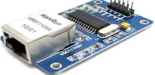
ENC28J60 Ethernet Module
ENC28J60 Ethernet Module utilizes the new Microchip ENC28J60 Stand-Alone Ethernet Controller IC featuring a host of features to handle most of the network protocol requirements. This Ethernet LAN module connects directly to most microcontrollers.
Figure 8: Ethernet Module Description:
Ethernet LAN Module for Arduino/AVR/LPC/STM3 ENC28J60 Ethernet chips
Can be easily mounted with the MCU Network Interface: HR911105A
Supply Voltage: 3.3 V (5V Tolerant DIO) 25 MHz crystal oscillator
Size (L x W x H): Approx. 2.3 x 1.3 x 0.7 inch / 58 x 34 x 17 mm
V. CONCLUSION
The current system utilizes thefixed point of dam monitoring instead of focusing onflood hotspot area. The concept of portable sensor for thisproject permits the sensor to be deployed only during inneeded period. In term of flexibility, this project modelcan be deploying anywhere related to fixed monitoringspot. In terms of annually maintenance cost, this projectonly consumes fewer budgetsthe self-monitoring in the FloodObservatory System ensures that the systemperforms efficiently and reliably for the monitoringstation. At the event of a system failure, whichincludes failure in the sensor unit and power supplyunit failure will be notified to the monitoring stationpersonnel via SMS in real time basis.
REFERENCES
[1] DIAD ALERT real-time weather monitoringand flood warning, DIAD Incorporated, 20September 2000,pp. 1-4.
[2] Guy Schumann, Renaud Hostache, ChristianPuech, Lucien Hoffmann, Patrick Matgen,Florian Pappenberger, and Laurent Pfister,High-Resolution 3-D Flood Information FromRadar Imagery for Flood Hazard Management,IEEE Transactions on Geoscience and RemoteSensing, VOL. 45, NO. 6, June 2007, pp. 1715-1725.
[3] Gerardo Di Martino, Antonio Iodice, DanieleRiccio and Giuseppe Ruello, A NovelApproach for Disaster Monitoring: FractalModels and Tools, IEEE Transactions onGeoscience and Remote Sensing, VOL. 45,NO. 6, June 2007, pp. 1559 – 1570.
[4]. Ramsey, W. and R. Burckley. 1966. Modern Earth Science. Quezon City: KENInc.
[5]. McDaniel, M., E. Sprout, D. Boudreau and A. Turgeon. 2012. Flood.<http://education.nationalgeographic.com> date accessed 17 August 2013 [6]. Mwape Y. P., 2009. An impact of floods on the socio-economic livelihoods of people:A case study of Sikaunzwe community in Kazungula District of Zambia.University of the Free State Faculty of Natural and Agricultural SciencesJournal 1(1): 1-87.
[7]. Devalsam E, I., J. E. Atu, C. Oko, I. Ekwok. 2011. Flood and its impact onfarmland in Itigi, Abi Local Government Area, Cross river State, Nigeria.International Journal of Humanities and Social Sciences 1(9): 98-104.
[8]. Lu, J. and K. Whitehouse. 2007. Flash flooding: Exploiting the capture effects forrapid flooding in wireless sensor networks. Department of Computer Science,University of Virgina Journal 1(1): 1-9
[9]. Khalequzzaman M. D. 2009. Flood control in Bangladesh through bestmanagement practices. Department of Geology and Physics Journal 3(7): 1-13.
[10]. Simonovic, S.P. 1999. Decision support systems for flood control management in theRed River Basin. Canadian Water Resources Journal 24(3): 203-223.
ISSN (Print) : 2320 – 3765 ISSN (Online): 2278 – 8875
I
nternational
J
ournal of
A
dvanced
R
esearch in
E
lectrical,
E
lectronics and
I
nstrumentation
E
ngineering
(An ISO 3297: 2007 Certified Organization)
Website: www.ijareeie.com
Vol. 6, Issue 2, February 2017
[12]. Molino, B. 2002. Bells and whistles, belts and braces: designing an integrated floodwarning system for the Hawkesbury Nepean Valley. <http://www.ses.nsw.gov.au/content/documents/pdf/research-papers/42898/Bells_and_whistles_belts_and_braces_part_1.pdf> date accessed 17 August 2013.
BIOGRAPHY
Tayyabunnissa Begumcurrently working as AssistantProfessor in ECE Dept. of Lords Institute
of Engineering and Technology, Hyderabad, Telangana, India.
Chilka Nareshpresently pursuing B.Tech 4th Year in Lords Institute of Engineering and
Technology, Hyderabad, TelanganaIndia.
Gundam Ashok presently pursuing B.Tech 4th Year in Lords Institute of Engineering and Technology, Hyderabad, TelanganaIndia.
Susheel Vishwakarmapresently pursuing B.Tech 4th Year in Lords Institute of Engineering and
Technology, Hyderabad, Telangana India.