SITE DOCUMENTATION
NURUL SHAHIDA BINTI SULAIMAN
A thesis submitted in fulfilment of the requirements for the award of the degree of
Master of Science (Geomatic Engineering)
Faculty of Geoinformation and Real Estate Universiti Teknologi Malaysia
Dedication
From the bottom of my heart,
I would like to dedicate this thesis especially to
my beloved mother, Norizan Binti Osman, my father, Sulaiman Bin Simat and both of my siblings. They became the strength and the remedy for me
every time obstacles struck me off.
In addition, this thesis is also dedicated to my soul mate,
Mohd Hafiz Shafiq bin Hamdan who has supported me in many aspects. Thank you for all your encouragement and undefeated courage
ACKNOWLEDGEMENTS
First and foremost, all praise to Allah, the Almighty, and the Benevolent for His blessings and guidance for giving me the inspiration to embark on this research project. He was instilling me the strength to see that this task becomes a reality. Completing this project has been one of the most significant academic challenges I ever had to face. Without the support, patience and guidance of the following people, this task would not have been completed. It is to them I owe my deepest gratitude.
I would like to gratefully acknowledge the enthusiastic supervision by Assoc. Prof. Dr. Zulkepli Majid and Prof. Dr. Halim Setan, for guiding me throughout this project. They are the positive forces for me to keep enhancing my work. Thanks again for planning every presentation along the way of conducting this project and for all the critics, they were the key for me to do better in my research. Apart from that, I would like to express my gratitude to Dr. Albert Chong who has abundantly helpful and offered invaluable assistance, support and guidance during my research.
ABSTRACT
ABSTRAK
TABLE OF CONTENTS
CHAPTER TITLE PAGE
STUDENT'S DECLARATION ii
DEDICATION iii
ACKNOWLEDGEMENT iv
ABSTRACT v
ABSTRAK vi
TABLE OF CONTENTS vii
LIST OF TABLES x
LIST OF FIGURES xi
LIST OF ABBREVIATIONS xxi
LIST OF APPENDICES xxii
1 INTRODUCTION 1
1.1 Introduction 1
1.2 Research Background 1
1.2.1 Research Concept 2
1.2.2 Study Site and Data Specification 4
1.2.3 Instruments and Software 7
1.3 Problem Statement of the Research 9
1.4 Research Aim 12
1.5 Research Objectives 12
1.6 Research Questions 13
1.7 Scope of the Research 13
1.8 Significance of the Research 14
1.9 Thesis Organization 16
2 ARCHAEOLOGY: WHERE THE PAST REALLY MATTERS 18
2.1 Introduction 18
2.2 Basic Concept of Archaeology 19
2.2.1 Fundamental Activities in Archaeology Work 22
2.2.2 The Important of Archaeology 28
2.3 Archaeology Documentation 30
2.4 Virtual Archaeology – From Site to Community 32
2.5 Archaeology Practice in Malaysia 35
2.5.1 Bujang Valley - The Core of Ancient Civilization 37 2.5.2 Archaeological Documentation Method in Malaysia 39
2.6 Summary 41
3 MULTI-SENSORS UTILIZATION FOR ARCHAEOLOGICAL SITES
RECORDING 42
3.1 Introduction 42
3.2 The Role of Sensors Technology in Archaeology Work Phases 43
3.2.1 Site Recognition 45
3.2.2 Regional Survey 47
3.2.3 Site Survey 52
3.2.4 Archaeological Monument Modelling 55
3.2.5 Archaeological Artefacts Mapping 66
3.3 Summary 69
4 RESEARCH METHODOLOGY 70
4.1 Introduction 70
4.2 Research Framework 71
4.3 Data Acquisition for Bukit Batu Pahat Shrine 75 4.3.1 Site Surveying: Creating Control of Archaeological Site 76 4.3.2 Spatial Data Collection using Terrestrial Laser Scanner 78
4.3.3 Capturing High-Resolution Images 84
4.5 Data Processing for Bukit Batu Pahat Archaeological Monument 90 4.5.1 Processing Leica ScanStation C10 Data: Point Cloud
Registration 91
4.5.2 Georeferencing the Point Cloud Model 99
4.5.3 Modelling the Point Cloud Model 101
4.5.4 Generating 3D Photo-Realistic Model via Mesh Model and High-Resolution Images Integration 111
4.6 Data Processing for Bukit Batu Pahat Archaeological Artefacts 115
4.7 Visualization of Bukit Batu Pahat Archaeological Site Models 119
4.8 Summary 121
5 RESULTS AND ANALYSIS 122
5.1 Introduction 122
5.2 Results and Analysis: Georeferencing 123
5.3 Results and Analysis: 3D Models of Bukit Batu Pahat Shrine 125
5.3.1 3D Point Cloud Model of Bukit Batu Pahat Shrine 126
5.3.2 3D Photo-Realistic Model of Bukit Batu Pahat Shrine 138
5.4 Results and Analysis: 3D Model of Bukit Batu Pahat Artefacts 149
5.5 Results and Evaluation of Bukit Batu Pahat Archaeological Site Visualization 154
5.6 Summary 157
6 CONCLUSION AND RECOMMENDATIONS 158
6.1 Introduction 158
6.2 Conclusion 159
6.3 Recommendations 161
REFERENCES 163
LIST OF TABLES
TABLE NO. TITLE PAGE
1.1 Geomatic sensors and data processing software used in this study
8
2.1 Level of threats on the countries with heritage potential 36
3.1 Size of archaeology site versus suitable Geomatic tools 44
3.2 Criteria for choosing suitable GPS in archaeology work 55
3.3 The mapping scale requirement for geometric documentation 57
3.4 Accuracy requirement in archaeological site recording 57
4.1 Technical specifications of NextEngine laser scanner’s acquisition modes
86
5.1 The constraint weight values and the effect on registration as stated in Leica Geosystems Training Materials
130
5.2 Registration quality based on the error values as stated in Leica Geosystems Training Materials
131
5.3 Results of aligning Faro data sets into existing 3D point cloud model
137
5.4 Comparison between on site measurements and virtual measurements
140
5.6 Feature mapping analysis – comparing holes of the shrine 146
5.7 Feature mapping analysis – comparing broken rock of the shrine
147
5.8 Result for artefacts modelling 150
5.9 Differences between on-site measurement and virtual measurement for artefact models
152
LIST OF FIGURES
FIGURE NO. TITLE PAGE
1.1 Field drawing and notes made by archaeologist 3
1.2 Location of the study area; Bukit Batu Pahat shrine in Bujang Valley
5
1.3 Place of worship for Hindu religion, Bukit Batu Pahat shrine is the largest shrine among other shrines in Bujang Valley
5
1.4 Selected artefacts from Bukit Batu Pahat Shrine 6
1.5 Bujang Valley Archaeological Museum website 11
2.1 Artefacts found at Sungai Batu Complex, Bujang Valley, Kedah. From left; pieces of a pot, bead from carnelian and spindle whorl
19
2.2 Documenting the Sphinx by using RiSCAN PRO 1.1.2β. Textured model (left) and triangulated point cloud (right)
21
2.3 The Fort in Kilwa Kisiwani, also known as Geresa (prison) is in poor condition
22
2.4 Workflow of fundamental activities in archaeology 23
2.5 Output from regional survey; a settlement pattern for Zhou dynasty in China
25
2.7 Procedures used for archaeological data acquisition and documentation
26
2.8 Conventional tools used in collecting and recording archaeology findings
27
2.9 Tools for heritage recording: (a) measuring tape and plumb line, (b) electronic distance meter, (c) digital camera, (d) Tablet PC, (e) total station
27
2.10 Interior part of Skara Brae house 29
2.11 Research design for archaeological documentation 31
2.12 Magic Screen kiosk in Hellenic Cosmos, Greece 33
2.13 The web-based interactive visualisation and query for data exploration in QueryArch3D
33
2.14 Reshaper Viewer 2013 window; (1) Main Menu, (2) Explorer, (3) and (4) Graphic View
34
2.15 Most shrines in Bujang Valley (red dots) are located in the jungle
35
2.16 Maritime routes connecting merchants from Arab, India and China with Malay Peninsula
37
2.17 The distribution of archaeological sites in Bujang Valley 38
2.18 Conventional method used in archaeological research 39
2.19 Part of the coded drawers in the store room 40
3.1 Numerous surveying methods attached on various
platforms are being used in archaeological documentation
44
3.2 Pedestrian survey in North Duffield 45
3.3 A resistivity survey of the Fanum (temple area) at Vieil-Evreux, France using GPR
3.4 (a) Aerial photograph with the location of buried archaeological remains derived from geophysics superimposed; (b) Shaded relief surface derived from LiDAR data; (c) output of the ReedeXiaoli algorithm for CASI imagery; and (d) output of the ReedeXiaoli
algorithm for the daytime ATM imagery
47
3.5 Regional survey at Chiapa de Corzo, Mexico 48
3.6 Iron Age hillfort in Leitha mountain; (a) Photo-mosaic of the area and (b) DEM of the area derived after filtering Lidar data using the theory of robust interpolation
49
3.7 Two stone-built enclosures at Carrig Aille, Co. Limerick, part of the Lough Gur complex, Ireland. (Department of the Environment, Heritage and Local Government)
50
3.8 Aerial photogrammetry using balloon as a platform is subjected to the wind
51
3.9 Flight plans and planned reference points pattern 51
3.10 Right image; Horizontal control for Gatecliff Shelter's excavation. The grids are one meter square designated by unique alpha-numeric systems. Left image; stratigraphy layers with periods identification of Gatecliff Shelter
52
3.11 The ‘divorced’ survey (a’, b’, c’, d’) has good relative accuracy as the points are positioned correctly in relation to one another, but poor map accuracy when compared to the positions (a, b, c, d) of a map
54
3.12 Process of sketching a byre at Gramadale, Benbecula by using measurement tape and manual drawing
58
3.13 Processes involve in image-based modelling 59
3.14 Digitizing façade of the monument using photogrammetry software
60
3.15 Geometric extraction from 3D point cloud based on point discontinuities, which also known as discrete curves approach
61
3.16 3D model of Chester City Wall produced by extracting the information from point cloud data using AutoCAD 3D
62
3.18 The revolution of Faro laser scanner; from using external camera (Faro Photon 120/20) to a built-in camera in scanner (Faro Focus 3D)
64
3.19 Texturing 3D point cloud of Sint-Baafs Abbey using images captured by a built-in camera in Leica ScanStation 2
64
3.20 3D texture model of Portal of Saint-Trophime, Arles which generated by using photogrammetry technique from 90 images
65
3.21 Merging digital images with 3D surface model by selecting common points from each data
65
3.22 2D image and 3D textured model of Porta' de Santiago 66
3.23 A precisely pedestal model acquired using photogrammetry method
68
3.24 Reconstruction of a ceramic pot using close-range laser scanner. (a) After combining the pieces found. (b) 3D mesh of the ceramic pot
68
4.1 Methodology for recording archaeological site documentation in Bujang Valley
72
4.2 Control point distribution around Bukit Batu Pahat shrine. Point 1 and Point 2 were observed to comply the GPS survey requirement to be used as a datum
73
4.3 Leica GPS and Leica total station TCR307 used in this research
77
4.4 Two main instruments used in monument mapping phase; Leica ScanStation C10 (left) and Nikon DSLR D300s (right)
79
4.5 Target distribution around Bukit Batu Pahat monument 80
4.6 Tilt and turn HDS target provided by Leica Geosystems; square target (left) and circular target (right)
81
4.7 Main Menu for Leica Scan Station C10 81
4.8 Scanning configuration and scanning parameters used in this research
83
4.9 Coloured point cloud of Bukit Batu Pahat shrine provided by Lieca Scan Station C10
4.10 A set of NextEngine 3D Laser scanner; NextEngine scanner, auto drive, part gripper, combination of all the things and the toolkit
86
4.11 Scanning setup for NextEngine laser scanner and other complemented equipment
87
4.12 Interface to view artefact’s position and to setup scanning parameters
88
4.13 Workflow for archaeological monument data processing 90
4.14 Workflow to create a new database in Cyclone 7.3 92
4.15 Hierarchy of files in a Project imported to Cyclone 93
4.16 Either one these scanning datasets (in red box) is incomplete dataset
93
4.17 Two different datasets of scanning point number pt2 (a) Incomplete scanning dataset, (b) Complete scanning dataset
94
4.18 Cloud Constraint Wizard is necessary when applying cloud-to-cloud registration method
95
4.19 Marking corresponding points on every ScanWorlds 95
4.20 Error Vector / RMS value for this research 96
4.21 Cloud Constraints Wizard that allow user to view, accept or reject the selected corresponding points
97
4.22 3D point cloud model of Bukit Batu Pahat shrine in Cyclone
97
4.23 Summary for point cloud processing in Cyclone 7.3 98
4.24 Point cloud model of Bukit Batu Pahat shrine and the scanner position
4.25 The position of the scanner is modified in the Transformation menu
100
4.26 3D point cloud model of Bukit Batu Pahat shrine; the structure of the shrine can be defined easily (top), it is difficult to define the stairs when getting closer to the point cloud model (bottom)
101
4.27 3D Reshaper 7.1 user interface 102
4.28 Compatible point cloud file format for 3D Reshaper 7.1 103
4.29 Process of importing 3D point cloud model into 3D Reshaper 7.1
103
4.30 3D point cloud models for Bukit Batu Pahat shrine in different types of file formats
103
4.31 Workflow for Cleaning Point Cloud process 105
4.32 Areas that are not covered by Leica scanner 105
4.33 Faro data set is used as a complementary data in this research
106
4.34 The result of combining Faro data to cover the missing part in the point cloud model
107
4.35 Parameters for 3D Mesh Creation 108
4.36 3D mesh model of Bukit Batu Pahat shrine 109
4.37 3D meshes of the monument before and after smoothing process
110
4.38 Holes in the 3D mesh model of Bukit Batu Pahat monument
110
4.39 Windows to define parameters for texturing process 113
4.40 The process of texturing Bukit Batu Pahat shrine by integrating 3D mesh model and digital images
114
4.42 Scanned data for one artefact before aligned 116
4.43 The placement of corresponding points in a good geometry 117
4.44 Bukit Batu Pahat Artefact; before and after trimming 117
4.45 Tools provided by ScanStudio HD for 3D model enhancement
118
4.46 The summary for artefact data processing in ScanStudio HD
118
4.47 Interface for Reshaper Viewer 2013 119
4.48 Measurement onto 3D artefact model in Reshaper Viewer 2013
120
5.1 View coordinates of a point via Properties menu (above) or by referring to the corner left of the window (bottom)
123
5.2 Checking the coordinates used to georeference Bukit Batu Pahat archaeological site
124
5.4 Workflow for Bukit Batu Pahat shrine models analysis 126
5.5 Unregistered ScanWorld for each scanning points (green circle)
127
5.6 Curve in the histogram defined the quality of alignment 128
5.7 Alignment quality between two ScanWorlds 128
5.8 Registration results for Bukit Batu Pahat shrine 129
5.9 Checking the quality of registration by applying different colours for each scanning point
132
5.10 Successful registration result for Bukit Batu Pahat shrine 132
5.11 Process of cleaning up points that do not belong to the shrine
5.12 (a) A complete 3D point cloud model of Bukit Batu Pahat shrine
133
5.12 (b) Close – up view of Vimana 134
5.12 (c) Close – up view of Vimana’s structure 134
5.12 (d) Back view of Bukit Batu Pahat shrine 134
5.13 (a) First result for aligning two different sources of laser data 135
5.13 (b) Second result for aligning two different sources of laser data
135
5.13 (c) Third result for aligning two different sources of laser data 136
5.14 3D point cloud model after combining with all Faro data sets
136
5.15 The result of combining Faro data with existing point cloud model
137
5.16 3D point cloud model of Bukit Batu Pahat shrine when applying colour from the scanner
138
5.17 Information for Bukit Batu Pahat point cloud model 139
5.18 3D mesh model of Bukit Batu Pahat shrine 140
5.19 Measurements of the shrine for geometric accuracy validation
141
5.20 Corresponding points are marked on the 3D mesh model and images
142
5.21 Image distortion due to insufficient corresponding points 143
5.22 The same area of the shrine with different weather condition
143
5.23 The image is well textured and followed the shape of the structure
5.24 Alignment quality is shown in the red box 151
5.25 The thickness of the Dutch bowl and diameter of the pieces of bowl is measured using vernier calliper and compared with a virtual measurement
151
5.26 Artefact model without zooming in (left) and when zooming (right)
152
5.27 Very dense point cloud formed Bukit Batu Pahat shrine 154
5.28 Mesh model of Bukit Batu Pahat shrine in different point of views
155
5.29 A mesh model and photo-realistic model of an artefact 156
LIST OF ABBREVIATIONS
2D two-dimensional
3D three-dimensional
4D four-dimensional
BC Before century
DEM Digital Elevation Model
GPR Ground Penetrating Radar
GPS Global Positioning Systems
HD High Definition
HDS High Definition Surveying
IMU Initial Measurement Unit
LiDAR Light Detection and Ranging
m metre
mm millimetres
RMS Root Mean Square
LIST OF APPENDICES
APPENDIX TITLE PAGE
A Leica ScanStation C10 Specification 182
B Nikon D300s Specification 183
C Edit Preferences menu in Cyclone 184
D Registration Diagnostic file 185
CHAPTER 1
INTRODUCTION
1.1 Introduction
The purpose of this introductory chapter is to provide and highlight the main ideas of this research. Initially, some definitions and concepts related to this study are briefly explained. Several current issues are exposed to know the importance of carrying out this research. The aim and objectives of this research are also pointed out in this chapter. Besides that, scope of the research is outlined in the next section to emphasize the research's limitation. Finally, the contributions of this research and thesis organization are clarified at the end of this chapter.
1.2 Research Background
1.2.1 Research Concept
Archaeology is a scientific study, which carried out in order to re-create the events of the past and reconstruct the lifestyle of prehistoric people and their culture through the study of artefacts, monuments and other remains left behind (Saskatchewan Archaeological Society, 2010). According to Kipfer (2000), the features or remains belongs to ancient people are surveyed, excavated and record systematically in order to unveil the history of the past, to study the cultural process and reconstruct the lifestyle of the ancient people. There are several ways of finding the remains i.e. accidentally found during farming or construction, excavation at the predicted site and by using geophysical technique to detect things lie beneath the ground.
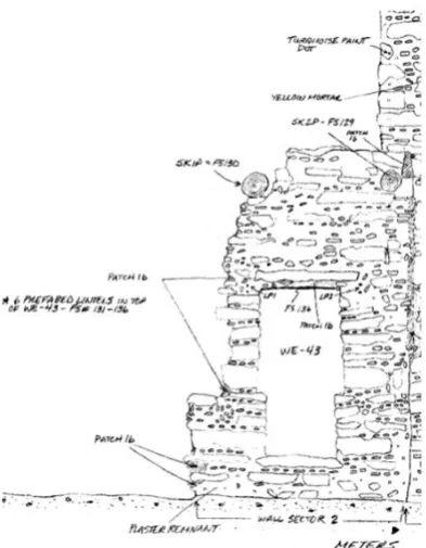
In order to interpret the life of people from the past, all the remains found either monuments or artefacts must be precisely documented in the form of analytical and critical reports, illustrated with drawings and photographs (Haddad and Akasheh, 2005). After excavation process is finished, archaeologist will draw a plan that represents the result of the excavation with a complete detail of measurements, soil and artefacts or monument found (Figure 1.1). Rationally, bigger archaeology site requires longer time to be drawn manually. A proper documentation with sufficient information will be the basis for various treatment activities, including research, interpretation, preservation, reconstruction, stabilization and data recovery (Stanco et al., 2011).
Figure 1.1: Field drawing and notes made by archaeologist (Patel, 2009)
Documentation, conservation and restoration of archaeological sites requires accurate spatial information such as geometric of the structure, shapes of remaining walls, physical extent of erode surfaces, thickness of walls, dimensions of features and so forth (Miri and Varshosaz, 2005). Additionally, instead of requesting spatial information of the structure or the artefact, there is a strong demand for photo-realistic three-dimensional (3D) models of archaeological monument and artefacts (Aguilera and Lahoz, 2006). Ergincan et al. (2010) stated that advanced Geomatic technologies offer rapid, accurate and detailed documentation solutions on the physical characteristics of artefacts and archaeology sites (Section 3.2).
Due to the complexity of some structures and the lack of a single tool in giving satisfactory results in all measuring conditions, Geomatic tools are integrated to get precise photo realistic model of archaeology site (Gonzo et al., 2007). Hence, this research is carried out to develop method for generating photo realistic 3D model with required geometric accuracy of Bukit Batu Pahat shrine and its artefacts by the means of multi-sensors data integration. Global Positioning System (GPS), total station and Leica ScanStation C10 were used to record spatial data of the shrine. Due to the low quality of the coloured point cloud provided by the scanner, a digital camera, Nikon D300s is used to capture photos of the shrine for texturing purpose. The integration results are presented in term of accuracy and quality of the model.
1.2.2 Study Site and Data Specification
Previously in 1840s, Colonel James Low, of the East India Company, detected an undoubted relic of Hindu colony in Kedah thus starting an investigation (Tourism Malaysia, 2008). Other people continued his effort in 1920s, 1930s and 1936. Eventually, the ruins of the temple, which believed to have been built during the 11th century, was reconstructed in 1960 at its original location with the help from Universiti Malaya and the Angkor Wat Conservation Centre in Cambodia. Bukit Batu Pahat shrine is considered as Malaysia’s version of Angkor Wat in Cambodia.
Bujang Valley is situated in Kedah, a state located at the north part of Peninsular Malaysia (Figure 1.2). Numerous shrines were found scattered in Bujang Valley. The unique architecture and design of every shrine has made the structure an important asset for Malaysia. The most prevalent shrine in Bujang Valley is Bukit Batu Pahat shrine (Figure 1.3). Bukit Batu Pahat is the largest shrine in the area and it is made of stones obtained from the river nearby. Of all the shrines, this monument is preserved on the exact place where it was found. Since this shrine is worth to preserved for generations to come, this structure is chosen to be scanned in this research and finally photo-realistic 3D model of the shrine is generated.
Figure 1.2: Location of the study area; Bukit Batu Pahat shrine in Bujang Valley
The archaeological area is approximately 48 x 40 metres and contains hundreds of religious artefacts. Various types of artefacts can be found during excavating the archaeological site. In Malaysia, the artefacts can be in the form of utensil, ancient water container, ornament, beads, keris and even skulls. Since the research area is located in Bujang Valley; which previously a well-known entrepot and ancient civilization, numerous kinds of artefacts from China, Britain and Netherland can be found there. However, in this research, artefacts related to Bukit Batu Pahat shrine are chosen as the study objects. The artefacts were stored in Bujang Valley Archaeological Museum. Artefacts chosen include a bronze container, silver piece of Hindu demigod, gold coin, Dutch bowl and kitchen stoneware (Figure 1.4).
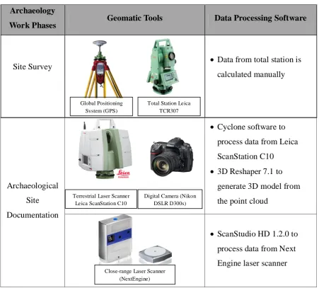
1.2.3 Instruments and Software
Fundamentally, two archaeological work phases are included in this research; site survey and archaeological site mapping. Site survey is a process of locating the site relative to the real world. Global Positioning System (GPS) was used to acquire coordinate of the archaeological site. Besides that, a total station was used to conduct control survey for covering the archaeological site area . The coordinates data gained from this phase is integrated with point cloud data generated by the terrestrial laser scanner. Hence, every point cloud scanned will have their own coordinates respective to the real world.
There are two types of archaeological findings documented in archaeological site documentation phase; the monument and the artefacts found during excavating the site. Different sizes between the two objects require different types of laser scanner. In order to generate highly accurate geometric and photo-realistic model, several Geomatic sensors are used to record spatial data and texture data of the shrine. A terrestrial laser scanner, Leica ScanStation C10 is used to acquire spatial information of the shrine. Using a built-in camera in the scanner, a low resolution images of the monument are captured. In order to achieve photo-realistic model of the monument, high resolution images are taken using Nikon D300s digital camera and integrated with laser data.
Table 1.1: Geomatic sensors and data processing software used in this study
Archaeology
Work Phases Geomatic Tools Data Processing Software
Site Survey
Data from total station is
calculated manually
Archaeological Site Documentation
Cyclone software to
process data from Leica ScanStation C10
3D Reshaper 7.1 to
generate 3D model from the point cloud
ScanStudio HD 1.2.0 to
process data from Next Engine laser scanner
The final outputs of this research are 3D photo-realistic model of Bukit Batu Pahat shrine and the artefacts found during excavating the site. In order to make the visualization interesting and effective where virtual analysis can be carried out, the output is presented in the form of 3D interactive visualization. 3DReshaper Viewer is used as a medium for data dissemination in this research. This software is capable of visualizing 3D models in various format such as .pts, . xyz, .msh, .dxf and .obj. The environment in 3DReshaper Viewer allows the objects to be viewed in orthographic and perspective view. Indeed, measurement onto the 3D models is available where a customizable report is generated based on the measurements made.
Global Positioning System (GPS)
Total Station Leica TCR307
Terrestrial Laser Scanner Leica ScanStation C10
Digital Camera (Nikon DSLR D300s)
Close-range Laser Scanner (NextEngine)
(Next Engine 3D Scanner)
1.3 Problem Statements of the Research
In this contemporary era, there is a high demand in documenting cultural heritage objects such as artefacts, sculptures and buildings (Boehler and Marbs, 2004). Moreover, as stated by Müller et al.(2004), people are looking forward for a high levels of detail and photo-realistic 3D model of archaeological findings. This is because an integration of detailed model with photo-realistic rendering can express the impression of reality that can never be achieved via single sensor. Besides that, realism and accuracy of the final 3D model are the important characteristics which archaeologists, historians, and museum practitioners strive to achieve and that the general public comes to expect (Roussou and Drettakis, 2003).
A nearly realistic 3D model is a model that has geometry and texture that almost the same with the original object and this model is useful in many applications such as in digital conservation, restoration, virtual reality applications, 3D repositories and web geographic systems (Remondino et al., 2008). Even though there is an alternative using computer graphic technique to provide textured 3D model, the output are sometimes being oversimplified yet neglecting the purpose to perpetuate the original appearance. On the other hand, there are two methods to generate 3D photo-realistic model as pointed out by Pavlidis et al. (2007); active method (i.e. terrestrial laser scanning) and passive method (i.e. photogrammetry).
A textured 3D geometric model is a highly desirable rather than the object representation since it gives full geometric dimension and allows unrestricted interactive visualisation with variety of lighting conditions (El-Hakim et al., 2008). Furthermore, the lack of geometric element can makes the model become unacceptable for documentation and reconstruction purpose (El-Hakim et al., 2004). According to Shu and Kwok (2009) laser scanner is the most suitable method to capture relatively accurate geometric details. Nonetheless, the edges cannot be well defined as one cannot be sure whether the laser hits exactly at the edge of the object or not (Koch and Kaehler, 2009).
In this research, a terrestrial laser scanner, Leica Scan Station C10 is used to scan a shrine which made of rock with rough surfaces and finally yield a high accuracy geometric model of the monument. A typical problem when generating a geometrical model is the edges of the model and therefore, Grussenmeyer et al., (2012) suggested that photogrammetry is the best complementary method for edge detecting. On the contrary, Boehler et al. (2003) pointed out that the essential object feature such as corner points or edges are not directly obtained; it must be extract from the point clouds. Hence, instead of using photogrammetry, data from the scanner itself can be used to overcome the problem. By increasing the scanning resolution, the point density will increase thus providing more points at the edge of an object. Hence, the edge detection process is easier when more points are available.
3D virtual archaeology has becoming a crucial need in every country. However, majority of online virtual archaeologies present information in two dimensional (2D) (Chapman et al., 2011). Additionally, Bujang Valley is still using digital images as a medium for virtual archaeology (Jabatan Muzium Malaysia, 2011). The aim of virtual archaeology is to make the data in a comprehensive manner which has academic integrity rather than simple aesthetic appeal (Chapman et al., 2011). Therefore, a virtual archaeology which can benefit scholars by providing access to the collections in 3D photo realistic with geometric dimension, allows object analysis and interpretation of the site is essential in this modern day.
Figure 1.5 shows the existing web based for Bujang Valley Archaeological Museum that is still using 2D digital images for data dissemination. There is no scale or measurement can be conducted on the findings. In photo gallery site, the only feature provided is caption for the pictures, explanation, zooming function and image provider. A 2D presentation for this place cannot be used to create 3D virtual archaeology for Bujang Valley. Hence, the results obtained from this research are displayed interactively in a desktop-based environment by providing photo-realistic model visualization, mesh model and measurement tools for each of the artefacts and monument of belongs to Bukit Batu Pahat archaeological site.
1.4 Research Aim
The aim of this research is to produce three-dimensional (3D) photo-realistic model with required geometric accuracy of archaeological monument and artefacts via multi-sensors data integration.
1.5 Research Objectives
Three objectives are designed in order to successfully achieve the research aim. The objectives are listed as follow:-
a) To evaluate methods for integrating multi-sensors data with the aim of producing three-dimensional photo realistic models of archaeological monument and artefacts.
b) To determine the geometrical accuracy of the archaeological monument model generated independently via terrestrial laser scanner, Leica Scan Station C10.
1.6 Research Questions
At the end of this research, this research is able to answer the following questions:-
a) What kind of suitable methods to be used to generate 3D photo-realistic model of monument and artefacts?
b) How to integrate different types of sensors data to get 3D photo-realistic model of a monument?
c) By manipulating the resolution of scanning, how effective and reliable can the laser scanner be to produce a model with required geometric accuracy? d) Why is so important to document a 3D model with photo-realistic appearance
and geometric measurements?
e) What is the suitable platform to share the 3D model so that the information is accessible by the citizen, researchers and historians?
1.7 Scope of the Research
Besides that, this research is only aim to document the remains that has been found without involving with the process of excavation. Thus, there is no information about the excavation grid or the pit level where the artefacts found. One monument is chosen as a study area and the artefacts found during excavating the site are scanned. The multi-sensors data integration is mostly focusing on the monument documentation. Basically, coordinate data, photogrammetry images and laser data of the monument are fused . On the other hand, only a close range laser scanner is used to scan the artefacts.
In the visualization part, only 3D surface models and the 3D photo-realistic models are display instead of point cloud and wireframe. Accuracy for each model is referred to a standard required by archaeologists. Feature mapping analysis was conducted by comparing digital 3D model with correspondence images to evaluate texture quality of 3D photo-realistic model. Additionally, geometric mapping accuracy was carried out by comparing virtual measurement of the 3D models with on-site measurement using measurement tape.
1.8 Significance of the Research
Preservation of archaeological sites will bring significant contribution to the country especially in tourism activities. Systematic management and preservation of archaeological sites will increase tourism activities because activities will act as an economics sources for a country. Currently, the lost of archaeological cultural heritage is faster than it can be documented. Major disasters, which caused the vanishing of archaeological heritage site, are human and natural disasters (Letellier et al., 2007). Human trigger off wars, uncontrolled development and recklessly build squatters. Concurrently, archaeology sites are facing enormous natural disasters, such as air pollution, acid rain, flood and earthquake.
By implementing laser scanning technology in recording archaeological monument, the geometrical dimension of the structure can be extracted. Thus, using the information given, the structure can be digitally reconstruct if it is destroy by natural disaster and no longer available to be visited. A sustainable development can be achieved in which human needs are fulfil while preserving the environment so that both development and ancient remains are enjoyed not only in the present, but also for generations to come. Besides that, by visualizing 3D photo-realistic model of the remains in an interactive environment, it will initiate a new way of data dissemination that is more effective and interesting. Archaeologists and researchers can conduct virtual measurements and share their findings without having to be in-contact with the object.
1.9 Thesis Organization
This thesis consists of six chapters. Chapter 1 clarifies the main ideas comprised in this research including the concept, description of the study area and also instruments and software that used to perform this research. Some explanations to justify the important of carrying out this research are also being discussed in Section 1.3. The aim and objectives of this research are pointed out in Section 1.4 and Section 1.5. Besides that, scope of the research is outlined in the Section 1.6 to emphasize the research's limitation. Finally, the contributions of this research are explained at the end of this chapter.
Chapter 2 and Chapter 3 are mainly about reviewing and explaining the basic concept, conventional and current trend in archaeological documentation. Basically, the definitions of common terms used in archaeology field, theory in archaeological documentation, existing and current method used for documenting archaeological remains are described in the second chapter. Additionally, the third chapter explained about the role of several sensors that have been successfully applied in archaeological field. The utilization of every sensor to record different types of archaeological remains is discussed in term of advantages and disadvantages of the sensor.
Chapter 5 is where the results are discussed and analysed critically. Section 5.2 is discussing about the result for creating control of the archaeological site and georeferencing the point cloud. The accuracy for traversing also being analyzed. This is followed by the results and analysis of Bukit Batu Pahat shrine models. The section is divided into two sub-sections; (1) results and analysis of the point cloud model, (2) results and analysis of the photo-realistic model which explained about data integration results and data quality assessment. Finally, evaluation for the visualization is discussed in the last sub-chapter. Chapter 6 is the final chapter in this thesis that generally conclude what the research has achieved, problems faced also some recommendations for future research.
1.10 Summary