Gravel Pit Rehabilitation Near Shallow
Municipal Wells – Threat or Opportunity?
Tanya Kampherm Martin, Scott Lister &
Wendy Kemp
Regional Municipality of York, Newmarket, Ontario, Canada
ABSTRACT
When the Regional Municipality of York was approached with the opportunity to work with local landowners to fill an existing abandoned gravel pit located next to a pair of shallow municipal wells, it was unclear whether the situation provided a cause for concern or an opportunity for improvement.
Under the Clean Water Act, 2006, activities on these lands require careful consideration and the need for a strong precautionary approach. The landowners’ intent was to place 1.15 million cubic meters of clean fill in the abandoned gravel pit. The Region was supportive of this application as the proposed filling operation offered an opportunity to further rehabilitate and enhance the protection of the shallow aquifer; however, the Region was very concerned regarding the impact of the filling operations on both the quality and quantity of the municipal drinking water supply. This process was further complicated since the Region does not have legislative authority over the local municipal bylaws for fill permits. In addition, there were no Provincial standards or protocols for fill permits to protect drinking water sources.
To meet the Region’s goals for the site, the Region worked in close coordination with the Town of Whitchurch-Stouffville to put a fill permit and an agreement in place with the landowners. Enhanced operational controls were put in place to provide additional assurance needed for the proper source protection of the municipal drinking water supply. Three key objectives were taken into account for the lands given their close proximity to the shallow municipal wells. Protocols and standards were put in place to confirm that source site material be certified as clean prior to importation. Secondly, site conditions required close monitoring to ensure that no adverse affects occurred. Lastly, enhanced protection of the municipal drinking water supply was recommended after the filling operations were to be completed.
Throughout the fill permitting process, procedures and standards evolved to improve operations and provide continuous protection of municipal groundwater supplies. To date, the site has received fill from over 18 sites since filling commenced in late 2010 and groundwater monitoring results indicate all standards are being met.
1 INTRODUCTION
Nestled on the Oak Ridges Moraine within a designated area for the protection of natural and open spaces, a former gravel pit was left as an ecological wasteland, marginally restored, based on current standards until a new landowner applied for a permit to fill the site with excess soil. Although posing no immediate threat to the nearby shallow municipal wells, the growing interest in source water protection spurred by the Clean Water Act
(2006), fostered a municipal-private landowner partnership in new and creative ways.
In the Province of Ontario, the legal framework for the removal or deposition of excess soils from water courses is well established. However in other areas, the deposition of excess soil is historically managed by the local municipal by-laws with typically less scientific rigour. That is, a landowner applies to the local municipality for a permit to allow for the deposition of soils called a ‘fill permit’. The permit imposes a number of conditions on the landowner to establish operational expectations. In highly sensitive areas, fill permits are typically declined for a couple of reasons. Firstly, the complexity of controlling the type of materials deposited can be very difficult and requires considerable oversight resources. Secondly,
neighbouring residents voice strong opposition typically due to noise and dust concerns but more recently a concern for their private well supply becoming contaminated. However, the local municipality can place sufficient precautionary controls through specified conditions within the fill permit, as experienced recently in Town of Whitchurch-Stouffville located in the Regional Municipality of York.
2 BACKGROUND
Located in the heart of southern Ontario, the Regional Municipality of York is one of the fastest growing municipalities in North America. Since its incorporation in 1971, York Region’s population has increased from 169,000 to over 1 million residents currently estimated. York Region will face a number of important issues as growth projections are expected to further increase to 1.5 million residents by 2031.
York Region covers 1,776 square kilometers (686 squared miles) with more than 69% of the landscape protected from development by Provincial legislation, resulting in a varied landscape from urban centers to forested naturalized lands. Transecting the Region is the Oak Ridges Moraine, a Provincially significant land
feature providing recharge for drinking water sources and headwater streams. Development is further restricted by the Provincial Greenbelt legislation which promotes the protection of environmentally sensitive and agricultural lands from urban sprawl. As a result of these restrictions, urban centers are centralized in the southern portion of the Region and along the central corridor. Outside these areas is a mix of smaller settlement areas within the rural landscape. The Town of Whitchurch-Stouffville is one of these settlement areas with a population of 37,000, located on the Oak Ridges Moraine along the eastern boundary of York Region.
With a two tiered governance structure, the delivery of municipal services is split between the Region and the nine local municipalities. Under the Municipal Act (2001), the local municipality is responsible for the local delivery of services including the issuance of fill permits. The Town of Whitchurch-Stouffville has authorized by-laws regulating the placing of fill and alteration of the grade of land within the Town boundaries in accordance with By-Law Number 2008-016-RE. The Town’s Site Alteration By-law outlines an extensive Environmental Control Program, including operational standards, fill screening and groundwater monitoring procedures. In addition, the landowner is required to enter into an agreement with the Town approved by Town Council, for sites of greater significance. However, the Region has overall responsibility for the coordination and delivery of municipal services including those pertaining to drinking water supply, wastewater treatment and source water protection. Where possible, the Region provides technical support with activities relating to the delivery of safe drinking water, which was the case with this particular fill permit proposal.
3 THE ISSUE
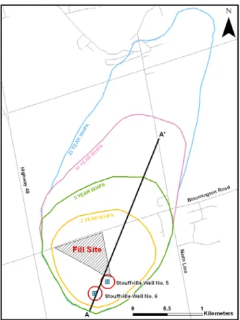
In the spring of 2009, The Town of Whitchurch-Stouffville received an application from a landowner to fill a large abandoned gravel pit with 1.15 million cubic meters with clean soil materials. The proposal included raising surface grades to restore the property to original elevations to restore to agricultural-rural land use. The abandoned gravel pit is situated adjacent and entirely within the 2-year capture zone for Stouffville Wells No. 5 and No.6 (Figure 1). Recognizing the potential source protection issues related to this application, Town staff involved Region technical experts early in the application process.
Stouffville Wells No.5 and No. 6 are two of the shallowest production wells in the Region, providing approximately a third (2000 m3/day) of the municipal drinking water to the Town of Whitchurch-Stouffville. Well depths are 12.80 and 21.34 meters below ground surface (mbgs), respectively, screened within a shallow aquifer with minimal overlying protection resulting in the designation as Groundwater Under the Direct Influence of Surface Water (GUDI) as prescribed by the Safe Drinking Water Act (2002). Wellhead protection area zones for the wells extend to the northeast and exhibit a high vulnerability due to the shallow nature of the aquifer coupled with a thin layer of surficial deposits (Figure 2).
Despite geological conditions, groundwater quality is excellent, consistently meeting the Ontario Drinking Water Quality Standards (Ontario Regulation 327/08, 2008) for health parameters.
It was evident that rigorous controls would need to be developed to ensure that fill operations would not adversely affect the local shallow aquifer. Although, the Town’s By-law outlines the requirements of an environmental control program, additional assurance and due diligence was required to safeguard the existing water supply.
Figure 1. Stouffville Wellhead Protection Area showing Fill Site
4 THE PROCESS
Through consultation with Region Hydrogeolgists, the fill alteration permit created by the Town placed several new conditions that had not been previously considered in past permits.
4.1 Extensive Groundwater Monitoring Conditions
An extensive groundwater monitoring program for before, during and after the fill operations was embedded in the permit to provide sufficient data on any potential mitigation measures required. Prior to the commencement of fill operations, it was imperative to capture groundwater baseline conditions surrounding the fill site. A water well investigation report was completed to obtain baseline conditions of neighbouring residential wells within 500m
radius of the site, following a similar requirement established for contaminated site investigations. Neighbouring residential well investigation included a visual inspection of the water well, water level measurements, and sampling for bacteriological and chemical testing.
On-site groundwater monitoring program was also established, subject to approval by the Town and Region, in terms of design, construction and operation, to establish baseline conditions on-site and monitor groundwater conditions throughout the fill operations and for a period of 2 years afterwards. A total of 6 groundwater monitors were installed on the site, 4 down-gradient at the south end of the site and 2 up-down-gradient near the north end of the site based on a south, southwest groundwater flow. A comprehensive list of groundwater sampling parameters was established in order to effectively evaluate initial groundwater conditions on the site. Down-gradient wells were monitored on a bimonthly basis while up-gradient wells were monitored on a quarterly basis for water level measurements as well as bacteriological and chemical testing of the specified groundwater parameters.
4.2 Approval of Source Soil Sites prior to disposal
The landowner was required by the permit to ‘pre approve’ all source sites. Fundamentally, it was agreed that source sites had to be a low risk for contamination and demonstrate though extensive testing that the soils would meet potable standards for drinking water. Originally, the landowner’s plan was to import fill from low risk source sites, such as agricultural lands designated for development. However, the prevailing economic conditions at the time reduced the demand for large subdivision type developments, resulting in insufficient availability of suitable source sites from these low risk areas. As a result, when fill operations commenced in
2010, the only available source sites available were those from higher risk areas where soil contamination from historic industrial land use is prevalent. Since these higher risk source sites required a greater level of scrutiny, concerns were raised by the landowner regarding the length of time and effort which would be required for the Town and Region to approve these types of sites. Discussions between the Town, the Region and the landowner ensued, and a peer review consultant, paid for by the landowner, was deemed the most efficient method of providing hydrological review of potential source sites and groundwater monitoring reports, in a timely and efficient manner. Furthermore, a process flow chart was developed to clearly outline the processes involved with the selection and review of source sites as well as the required soil testing parameters.
The process flow chart outlines various possible scenarios associated with selecting source sites that would be suitable for the import of clean fill. Use of the flow chart streamlined the review time and was an effective communication tool for the landowner to clarify the expectations of a suitable source site. The process flow chart outlined a number of specific ‘decision points’ to confirm suitability which can be generally summarized as two decision phases.
Firstly, the general suitability of the site had to have been assessed in accordance with the Environmental Site Assessment (ESA). This documentation would be reviewed by the landowner’s qualified environmental consultant. A Phase 1 ESA identifies any potential or existing environmental contamination liabilities which may be associated with the source site. Subsequently, follow-up of the site will result in seven different categories, based on the results of the Phase 1 ESA. These categories are differentiated by the amount of time since the Phase I ESA was completed, the results of the ESA (e.g. Phase 2 ESA recommended but not completed), whether or not the site has undergone any changes since the Phase I ESA was completed, or whether the site crosses numerous property boundaries in the case of infrastructure projects (e.g. subway line construction). Based on the resulting category, soil screening and sampling requirements are specified.
Secondly, soil samples at the source site had to meet the ‘clean’ condition which is established under regulation for the clean up of contaminated sites (Ontario Regulation 269/11, 2011). The soil samples were collected by the landowner’s environmental consultant and analyzed for parameters identified based on the Phase 1 and 2 ESA results. A minimum of 30 soil samples are required for field screening of organic vapours, which may lead to additional soil sampling (e.g. such as volatile organic compounds and petroleum hydrocarbons), 15 soil samples are required for the analysis of metals and inorganic chemicals and a minimum of two samples are collected for other chemicals suspected to be present based on the Phase 1 and 2 ESA results, including phenoxy acid herbicides, PCBs, and organochlorine pesticides. Sampling protocols were outlined based on Section 36 of Ontario Regulation 269/11 Records of Site Condition, sampling and analysis of soil in stockpiles, which specifies that all sampling locations must be Figure 2. Stouffville Wells 5 and 6 Wellhead Protection
chosen so as to ensure uniformly distributed and representative sampling collection throughout the stockpile and sample locations must not be collected from the surface of a stockpile. Analysis of soil samples collected would conform to MOE Table 2: Full Depth Generic Site Condition Standards in a Potable Groundwater Condition for Agricultural Property Use (Ontario Ministry of Environment, 2011). Both soil and groundwater samples on-site were analyzed and compared to MOE Table 2. All of the above documentation is reviewed by the Town and Region’s peer review consultant, and subsequently recommended to the Town and the Region for final approval of the source site.
4.3 Communication Protocols during Operations
A protocol for communications including resident complaints and contamination issues that could arise throughout the duration of the fill operations was established and outlined in the conditions of the Permit. Contamination whether it be through on-site soil sampling, groundwater sampling of the monitoring well network or private wells in the surrounding area, would require immediate action by the landowner in order to allow the Region to assess the severity of the contamination issue in relation to the municipal drinking water supply and respond accordingly. Town staff was required to inspect and monitor the placement of fill through a ticket system and respond to any complaints related to the Operations. In addition, Regional staff conducted education seminars with fill operations staff to ensure they understood the sensitivity of the source protection area.
4.4 Reforestation of the Lands
Recognizing the limitations of the lands for re-development given the controls placed by the Oak Ridges
Moraine Conservation Plan Act (2001), Region staff
worked across departments to include a condition for reforestation of the adjacent lands to the Regional wells. For the past ten years, the Greening Strategy has planted over 50,000 trees in the ground and has an extensive funding program to work with landowners to reforest lands. The Region entered into a legal agreement with the landowner to allow the Region to prepare, reforest and monitor approximately 5.7 hectares of land for the purposes of restoring a forested community on-site and providing a buffer area around the municipal wells. The agreement also specifies that the landowner would be committed to protecting the reforested lands in such a manner that will not preclude the establishment of a forest community and to permit access to the lands by the Region for the purposes of monitoring and tending the new forest as necessary. To facilitate the establishment of the new forest, fill placement in these areas would require no less than 80 cm of uncompacted topsoil when achieving final grade of the lands and that the lands be stabilized with a cover crop conducive to reforestation.
5 LESSONS LEARNED
Despite the rigorous process involved with source site selection, some local residents continue to have concerns about dumping of fill from unapproved sites, noise and dust. The complaints seem to be limited to a very small proportion of the neighbours, and the Town has effectively dealt with complaints regarding dust and noise at the site. The Region has been involved in responding to complaints about dumping from unapproved sites, which has included reviewing soil sampling results collected at the site immediately following such complaints and evidence from the landowner showing all fill dumped at the site was from approved, clean locations. Thus far, there has been no evidence that fill from unapproved sites has been deposited at the site. To further discourage illegal fill dumping and address local residential concerns, signs were posted at the fill site to inform the public that the subject lands are in a sensitive wellhead protection area and that illegal dumping is prohibited (Figure 3). Should a contamination issue arise, records of incoming source site material would provide sufficient documentation to locate the final placement of a load (Town By-law).
Analysis of the potential source sites has also shown the soils meet the majority of the MOE Table 2 Standards for Agricultural Properties (Ontario Ministry of Environment, 2011), with the exception of two soil quality indicators. Some of the approved sites have electrical conductivity (EC) and/or sodium absorption ratio (SAR) values slightly above the Table 2 Standards. EC is an indication of soil salinity and SAR is a relation between soluble sodium and soluble divalent cations, usually calcium and magnesium (Oklahoma State University, L-297). The main concern associated with these parameters is the negative impact on the growth of vegetation. The Ontario Ministry of Natural Resources has a policy for the rehabilitation of pits and quarries under a site plan that specifies criteria for soils with elevated EC and SAR to be placed 1.5 m below the final ground surface (Ontario Ministry of Natural Resources, 2008). Although the site is not under a site plan, the policy’s criteria have been applied to this fill site. The groundwater monitoring also confirms that sodium levels in the groundwater are well below the Ontario Drinking Water Quality Standard, indicating there has been no negative impact to the groundwater quality from the importation of these soils. Background groundwater monitoring conditions discovered some anomalous results that had not been anticipated. The background sampling revealed issues related to cadmium levels in groundwater at the site. Levels above the MOE Table 2 Standard have been detected in both the up-gradient and down-gradient groundwater monitoring wells. However, the levels are below the Ontario Drinking Water Quality Standards (ODWQS). The results were misleading since cadmium concentrations in the soils at the site were consistently below the guideline, and re-sampling of the monitoring wells did not provide consistent positive results. Research into the matter indicated that potential sources of cadmium on-site could include vehicle traffic releasing metals from brake pads to the air and ground, for example from heavy truck traffic on the site and the adjacent busy roadway. Theoretically, if groundwater samples inadvertently contained some of this sediment then a false positive for cadmium could occur in the groundwater sample due to the sampling error. It was also found that groundwater with a high concentration of chloride could lead to leaching of cadmium from the soils. Groundwater in the up-gradient monitoring well does contain high levels of chloride and off-site sources of chloride (i.e. salting of the road) could therefore be contributing to the problem. The Region suggested re-sampling of the groundwater at the site using a different lab and the results were below the ODWQS. Although the source of error is assumed to be related to the sampling and lab methods, the issue of cadmium in groundwater will continue to be monitored closely.
6 SUCCESSES
Fundamentally, all parties agreed that the infilling of an abandoned gravel pit had significant environmental merits with the assumption sufficient controls were in place to reduce the risks to drinking water. There have been many successes associated with the rehabilitation of the
abandoned gravel pit since fill operations commenced in late 2010.
The true measure of success will be demonstrated through the groundwater monitoring to evaluate the protection of the municipal aquifer. Throughout the filling operations, the raw water quality at the production wells remained and continues to be similar to what it was prior to the commencement of fill operations at the site. The quality of groundwater at the fill site has also remained similar to the quality prior to the commencement of fill operations. Regional staff are encouraged by the results of the monitoring program and are hopeful the source site measures mitigated any concerns related to contaminated soils.
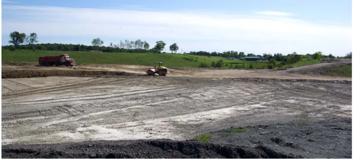
Effective monitoring of the source sites has been successful and has expedited duration of the fill operations. As of July 25, 2012, twenty one source sites have been approved, and over 90% of the site has been filled with clean soil (Figure 4). Although no sites were denied approval, the Region did restrict the removal of soil from some portions of select sites which were contaminated. The effectiveness of the site selection process is also further demonstrated through the results of the groundwater monitoring program.
The imported soils have increased the overlying protection of the municipal aquifer supplying the Regional wells. The characteristics of the imported soils have increased the travel time of recharge to the aquifer at the site due to the increase in volume and nature of material overlying the aquifer. Generally, the soils imported to the site have a lower permeability than the existing soils at the site resulting in increased travel times from surface to the aquifer and an associated increase in natural protection. The collaboration between the Greening Strategy and source water protection encouraged the reforestation and further protection of lands adjacent to the shallow municipal wells.
In addition, the permit fostered stronger working relationships between the two levels of government, the Town and the Region. Often with two levels of government, there is a disconnection in process. However, Whitchurch-Stouffville Town Council commended the Region early on in for its involvement in the fill permitting process and its commitment to protect the municipal drinking water supply. A greater understanding of Regional role and local municipal roles has improved and enhanced work in other related areas. Other municipalities have used this site as an example in developing their fill permitting programs.
7 CONCLUSION
The question still remains to be answered whether the rehabilitation of this abandoned gravel pit near a pair of shallow municipal wells will ultimately prove to be a threat or an opportunity. The fact that the site has been able to operate without any impact to a source of municipal drinking water to date shows that risk management does work. The measures imposed were much more rigorous than those associated with a typical fill permit and rightly so as to protect a valued municipal groundwater source. The easy option would have been to prohibit the fill
operation, but then the successes would not have been realized. Cooperative negotiation of the plan to manage risk required compromise and communication from all parties. Although there is no specific Provincial legislation controlling the fill operations, creative application of similar legislative tools and practices in place for contaminated soils enhanced the technical strength of the permit. The process created for this site can now act as a best management model for other types of development. It allows for fill operations to operate in a way that benefits the local community and does not pose a significant threat to the municipal drinking water supply. By imposing additional precautionary measures in order to conduct fill operations, public comfort has increased and local Councils are able to support the approach. More importantly, a former ecological wasteland has been now converted to rolling hills with forested lands for many generations to enjoy.
8 ACKNOWLEDGEMENTS
We would like to acknowledge Don Goodyear, Robin Courtney and Jenny Woodhouse for their assistance in the preparation of this paper.
9 REFERENCES
Clean Water Act. 2006. Municipal Act. 2001.
Oak Ridges Moraine Conservation Plan Act. 2001.
Oklahoma State University, L-297. Interpreting Soil Salinity Analysis. http://www.soiltesting.okstate.edu/ Extn_Pub/lab%20publications/L-297.pdf
Ontario Regulation 327/08. 2008. Ontario Drinking Water Quality Standards.
Ontario Ministry of Natural Resources. 2008. Importation of Inert Fill for Purpose of Rehabilitation. A.R. 6.00.03. Ontario Regulation 269/11. 2011. Records of Site Condition – Part XV.1 of the Act.
Ontario Ministry of Environment. 2011. Soil, Groundwater and Sediment Standards for Use Under Part XV.1 of the Environmental Protection Act.
Safe Drinking Water Act. 2002. Figure 4. On-site fill operations