Non-Point Source Pollution and the Clean Water Act:
Policy Problems and Professional Prospects
L. Allan James
University of South Carolina
S
uccessful implementation of water-quality management requires accurate scientific knowledge of water systems and sound judgment about environmental policy. This dual requirement calls for interactions between water scientists, managers, and policy experts who can jointly interpret and synthesize the data necessary for decision-making. With regard to non-point source (NPS) pollution in the United States, this set of interactions is increasingly structured by the mandates of the Clean Water Act (CWA). This paper examines the need for broadly trained water-resources specialists and how this need has been influenced by the CWA and institutional restructuring in the federal government.NPS Pollution and the CWA
The overarching goal of the CWA is to restore and protect the chemical, physical, and biological integrity of the nation’s waters (33 USC § 1251). This goal requires direct protection of water quality from point-source (PS), NPS, and ground-water pollution. However, these protections are only possible if the environmental systems linked to water quality are also protected. The need to manage environmental systems to meet CWA objectives has broadened the scope of water-quality management methods to include allied objectives such as aquatic and ecological restoration as well as floodplain and integrated watershed management. This paper is particularly concerned with NPS pollution: the social and environmental menace that contributes to the degradation of water quality, introduction of toxic substances to aquatic systems, eutrophication of
water bodies, filling of channels and reservoirs, fouling of wetlands, and increased risk of flooding. The CWA directly addresses NPS pollution reduction and has generated a new need for water-resources expertise in a variety of fields.
Getting the Dirt Out
A recent Congressional report by the Environmental Protection Agency (EPA) identified 96 U.S. watersheds as areas of probable concern due to contaminated sediment, and it also highlighted potential sources of contamination in need of further water-quality analyses (USEPA, 1998 a,b, and c). This report was the first comprehensive analysis and the largest collection of sediment chemistry and related biological data in U.S. history. Its three volumes both describe the location of potentially harmful levels of contaminated river, lake, ocean, and estuary sediments and assess potential adverse effects on human and aquatic life. Volume 1 (USEPA, 1998a) outlines the adverse human or ecological effects of sediment pollution. Volume 2 (USEPA, 1998b) presents related sampling station maps as well as chemical and biological summaries. Volume 3 (USEPA, 1998c) identifies likely PS contributors of sediment pollutants. In addition, technical manuals developed to assist states with TMDL procedures for nutrients, sediment, and pathogens review the status of scientific monitoring and assessment procedures (USEPA 1999a; 1999b; 2001). The need to monitor and understand NPS pollution will require research into NPS pollution processes and its remediation and a cadre of trained earth scientists and resources managers who have extensive knowledge of land and water management, water quality, hydrology, field methods, environmental economics, and spatial analysis.
The CWA: Brilliant Success or Dismal Failure?
Whether the CWA has successfully reduced NPS pollution depends on the data reviewed, the questions asked, and the perspective of the reviewer. The CWA stimulated the collection of water-quality data from various sources including NASQAN measurements (Alexander et al., 1996; USEPA, 2002) and the biennial National Water Quality Inventories presented to the EPA by the states as CWA reports. While NASQAN data collection is uniform and the data set is voluminous (i.e. in terms of the number of water-quality samples and parameters reported), the spatial array of gauging stations has been trimmed. The utility of an abundance of water-quality data in the United States is hindered by unsatisfactory standardized procedures for water-quality monitoring (Peters and Ward, 2003) and a paucity of synthesis and interpretation. Although the biennial state inventories
may provide generalizations at the state level, the lack of standardization between sample periods and among state agencies makes comparisons through time and space difficult.
Water-quality trends across the conterminous United States for the decade between 1980 and 1989 were summarized in the 1990s for six parameters: dissolved oxygen, fecal coliform bacteria, suspended sediment, nitrate, dissolved solids, and total phosphorous (Smith et al., 1993). During this period, mean dissolved oxygen (DO) concentrations kept pace with population and economic growth due to massive capital outlays for sewage-treatment infrastructure to treat PSs. As a result, fecal coliform concentrations gradually declined through the decade in all land-use categories except forested lands, thus reflecting improvements in PS pollution management. Suspended-sediment concentrations varied with geographic region but were highest in the West-Central region, where range and agricultural land as well as erodible soils are dominant. Between 1981 and 1989, concentrations of suspended solids declined, especially in the South-Central United States and along the Gulf Coast, presumably in response to improved soil conservation and reduced sheet and rill erosion. Although this data set is telling, its collection and analysis too closely followed passage of the CWA Amendments to be attributed to that legislation. Consequently, a new national synthesis of spatiotemporal water-quality trends and their relation to land-use changes is needed (e.g., through a systematic study of the National Resources Inventories).
sample sites may miss important repositories of pollution. Adler et al. (1993) point to weak and incomplete state and federal standards that represent only a small proportion of chemicals in a limited class of water bodies, and lack the necessary sampling of toxic materials in sediments and biologic tissues. Clearly, much work remains to be done on NPS pollution to achieve the CWA goals of “fishable and swimmable” waters.
Water-Quality Standards and the Need for Qualitative Judgment
The technical ability to measure water-quality parameters is substantial and continues to improve, but the political will to pay the costs has regressed. Public opinion polls consistently indicate that the public attach a strong value to environmental quality, clean water, and healthy living conditions. Nevertheless, government priorities are easily steered away from basic environmental concerns. Indeed, they often rationalize their reluctance to act decisively by citing limited medical knowledge and attendant uncertainties. Under present water-quality policies, these limitations often result in little or no regulatory action whatsoever. Our ability to determine the true medical risks of the vast array of potential chemical and biological agents in the environment will always be limited. One reason for this limitation is that the chemical industry produces new compounds far faster than controlled studies can be conducted on their potential hazard to human health. Other reasons include the physiological and genetic diversity of human populations, the large samples required for testing, and the long periods of experimentation needed to test for hazards of a single compound. At present, water-quality policy is flawed and reactionary insofar as regulatory action is held in abeyance until statistically significant proof of medical hazard can be produced. The establishment of water-quality standards should not be based solely on absolute proof using deterministic science; it should also be based on risks, ethics, morals, accountability, aesthetics, public policy, and common sense. Broadly trained environmental and resources professionals can and should play a role in the development of sound, conscientious environmental and public health policy.
The Trend Towards Decentralization
The EPA has been severely criticized for its inaction and slow compliance with its Congressional
directive to develop and enforce water-quality standards (Adler et al., 1993). To some extent, this criticism reflects administrative policies that limit federal regulatory oversight despite Congress’s clear mandate in the CWA. The often-expressed political mantra that less government is necessarily better than more government should be questioned, however, when water quality is at issue. Two examples illustrate this point. Early in the twentieth century, the combination of improved technology and water regulations resulted in safe drinking-water supplies and a dramatic reduction in drinking- water-borne disease. More recently, CWA regulations reduced PS pollution and resulted in substantially improved chemical water quality across the nation. Unfortunately, protection of water quality from pollution requires ongoing vigilance and some degree of coordination to develop and enforce uniform minimum standards. Protection of the nation’s waters is not a periodic task that can be accomplished when political and economic conditions are right and then discontinued indefinitely. Nor should protection of water quality be left entirely to local communities so that certain regions are allowed to degenerate into toxic wastelands. Since the down-sizing of the federal government in the early 1980s and the elimination of the Water Resources Council and river basin commissions, there has been a lack of central coordination or consistent water policy (Dworsky, 2000). The ongoing requirement for vigilance and coordination to maintain water quality leaves water resources vulnerable to discontinuities in political resolve, leadership, and organization. The present emphasis on decentralized, grass roots efforts such as watershed councils cannot fill this void in federal water policy leadership. While local involvement in resources policy is a positive step, it does not replace the need for water resources expertise and coordination. In fact, the loss of central leadership accentuates the need for expertise in physical and social sciences as well as in environmental and water policy.
An Integrated Watershed Perspective of NPS Pollution
resource-management programs in the United States have operated independently and have often competed with one another. A lack of coordination between programs frequently characterizes projects that traditionally focus on individual water bodies or specific goals such as flood control, recreation, drinking-water supply protection, wetlands rehabilitation, and waste-water discharge permitting. In contrast, watershed management emphasizes coordination and collaboration between groups on broad-scale environmental systems (USEPA, 1995; 1996). The Committee on Watershed Management provides the following description of watershed management:
Watershed management is a broad concept incorporating the plans, policies, and activities used to control water and related resources and processes in a given watershed.
(NRC, 1999a; p.14)
Early elements of integrated watershed management were practiced in the initiatives of the Upper Mississippi River Basin Commission, which was first established in 1879 (Mather, 1984). NPS pollution cannot be understood from traditional reach-scale analyses as commonly practiced by biologists, ecologists, and water chemists prior to the 1987 CWA amendments. To meet the mandates of the CWA, a broader scale of interagency water-quality research and an integration of social and physical processes became necessary. Since the 1990s, the EPA and other agencies have advocated a watershed approach as the prescribed method for addressing many environmental issues (USEPA 1995).
These integrative methodological changes are not easily made because they require the crossing of disciplinary and institutional boundaries. The fundamental divisions between physical and social sciences are difficult to span, but the divisions to be bridged by scientific and social institutions are even greater. Society operates within a fundamental paradox in which the public respects scientific research while democratic principles ensure that decision-making is performed by governments subject to political and economic pressures that have little to do with scientific methods. The political process always prevails over scientific methods in a democracy (Kelley, 1993). The politics of resource management are often guided by popular perceptions and vested interests, but their rationale may be cloaked in obtuse science. Given the differences
between scientific and political philosophies of resource management, the importance of public perception, and the need for interagency and interdisciplinary cooperation, water-resources managers must be versatile to be effective. Recognition of the growing need for the development of human resources in the water-resources field dates back at least to the 1977 United Nations Water Conference in Mar del Plata (Biswas, 1996). Given the increasing complexity of integrated approaches and the lack of federal guidance or coordination, the need for these resources remains today.
Putting Geographic Research
into a CWA Perspective
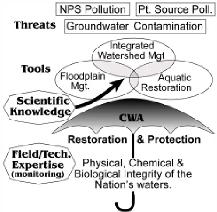
The CWA provides an impetus for applying basic watershed tools to protect the integrity of the nation’s waters from the threat of water pollution (Figure 1). Tools such as integrated watershed and floodplain management as well as aquatic restoration require planning and policy expertise in conjunction with scientific information about processes and the physical condition of the specific basin. Field and technical proficiency is needed to monitor and assess the condition of water bodies. The potential role that geographers can play in research and practical
aspects of the CWA is illustrated by a brief review of four traditional geographic research areas. The management of flood hazards is related to NPS pollution through common problems with sedimentation and potentially complimentary methodologies. Fluvial geomorphologists have studied sediment processes, historical alluviation, and aquatic restoration—processes and tools that are clearly relevant to management of NPS pollution. Geographic techniques have proven indispensable in a great variety of earth-science and resources studies, including analyses of watersheds and water quality. Finally, traditional geographic concerns with human-environment relationships and cultural regions at the global scale provide a unique perspective on modern interdisciplinary issues of food security, sustainability, and equity. Global water quality is gaining recognition as a central issue in international environmental policy considerations.
Flood-Hazard Management
Implementation of the CWA often has effects that extend beyond water quality. For example, management of flood hazards can be influenced by NPS pollution in several ways. First, sedimentation of channels, reservoirs, and wetlands reduces flood storage and exacerbates flooding. Second, the urbanization of wetlands, floodplains, and other lowland areas removes both flood storage and natural water-treatment functions. The mutual interdependence of water and environmental quality requires the protection of existing riparian, lacustrine, and other wetland areas from pollution, and this objective is compatible with many aspects of floodplain management. Third, diverse methodologies and jurisdictions used in floodplain and NPS-pollution management are complementary. Efforts to manage floodplains are often well-organized at the local government and community level, and they may include education and incentive programs. Conversely, regulatory provisions of the CWA can provide the authority needed to protect flood conveyance systems from sedimentation. Monitoring and controlling NPS pollution, therefore, can be tied to flood-hazard mitigation efforts and the social mechanisms utilized in floodplain management may be beneficial to water-quality management.
The pioneering efforts of geographers working on flood-hazard mitigation (e.g. White, 1945) have
considerable bearing on modern issues of water quality and sustainable environmental management. Behavioral geographers have been deeply involved in promoting the need to expand flood-hazard policy beyond the technological aspects of risk assessment and structural flood-control methods to also include vulnerability assessments and non-structural approaches to hazard mitigation. Given the need for decentralized land-use planning with voluntary cooperation and incentive programs to manage NPS pollution, an understanding of the National Flood Insurance Program and floodplain management principles enhances the potential for dealing with water-quality issues. In short, numerous benefits may arise from recognition of the common goal of reducing NPS pollution.
Sediment and Restoration
Understanding physical processes of sediment transport, deposition, storage, and remobilization is a central element of current research on how to implement CWA initiatives. Studies of these processes have provided important links between sediment and other NPS pollutants such as nutrients, metals, pesticides, and pathogens. For a quarter century without interruption, geographers have presented research on fluvial geomorphology at the national meetings of the Association of American Geographers (AAG). Some of these studies overlap in scientific methodology with engineering, but often a greater emphasis has been placed on the spatial and geomorphic aspects of processes including channel networks, spatial and GIS analysis, interactions with vegetation, influences of geologic structures, extended time periods, and broader basin-scale considerations. This long-standing tradition includes a large number of early broad-based watershed studies of NPS pollution.
comparison, indigenous agricultural technology in North America was simple and production was often limited by economies that were relatively subsistence based. Consequently, the sudden introduction of European culture to the New World caused an extreme disruption of biological and geomorphic stability, severe erosion, and deep valley alluviation. Although a delicate new balance has been reestablished in many basins, attempts to stabilize water and sediment systems must begin with the realization that many watersheds are fundamentally changed and geomorphically unstable. Tremendous repositories of sediment and other NPS pollutants on valley bottoms remain subject to remobilization. While these concepts are not often appreciated outside of geography and allied earth-surface sciences, the history and nature of historical sediment deposits have been a focus of many geographic studies over the past 30 years (Knox, 1972; 1977; Trimble, 1974; Graf, 1979). This perspective is critical to the development of accurate sediment budgets and the identification of sediment sources for long-range planning of watershed NPS loadings.
Aquatic restoration, an important tool for NPS-pollution management, seeks to re-establish the functionality of water bodies. As defined by the NRC (1992), the goal of aquatic restoration is to return a riparian or lacustrine system to a pristine condition. In the United States, this goal generally requires knowledge of channel morphology and watershed conditions prior to European contact. Fluvial geomorphologists have considerable expertise and a well-established research agenda in historical reconstructions of fluvial systems. Riparian, lacustrine, and wetland systems perform natural functions that protect and maintain water quality, so restoration of these systems following their loss to urbanization, agriculture, or other human developments may greatly reduce NPS pollution. Aquatic restoration has several benefits in addition to water-quality improvements such as ecological viability, recreation, esthetics, real-estate values, and flood control. Consequently, it is no surprise that river restoration projects can be traced back to the Greeks and Romans, Frederick L. Olmsted, and the New Deal (Riley, 1998). Although it calls for expertise in fluvial geomorphology, a field in which many geographers are well-trained, riparian restoration has been led largely by ecologists and executed by engineers. Until recently, fluvial geomorphologists
have been strangely reticent about the aquatic restoration movement. Their lack of input represents a lost opportunity and has often resulted in channel-rehabilitation projects that rely too heavily on bank stabilization and fail to provide esthetic or equilibrium designs.
The Role of Geographic Techniques
Remote sensing and digital mapping methods are rapidly changing the way that environmental variables are measured. While new mapping and analysis methods rapidly store, retrieve, process, and visualize spatial information, improved sensor capabilities and deployment allow enhanced detection. In addition, improvements in the spatial, temporal, and spectral resolutions of remote sensing methods allow for unprecedented precision and accuracy in the monitoring of environmental systems. For example, vegetation change or stress can now be monitored via satellite data and interpreted in terms of soil moisture, toxicity, and erodibility. Thermal pollution can be directly measured and monitored on a regular basis. Gullies can be mapped and their growth or stabilization monitored by repeat-flights collecting reflected laser light (Light Detection and Ranging, or LIDAR) data. In short, spatial databases and spatial decision-support systems (SDSS) are quickly becoming indispensable tools by which scientific information can be transferred to the public and decision makers. The growing need for global hydrologic data (NRC, 1999b) coupled with difficulties of directly measuring large diffuse surface-water fluxes through distributary channels, wetlands, and broad floodplains has created an important role for the remote sensing of global surface-water flows (Alsdorf et al., 2003).
Global Water Quality
availability of safe drinking water is threatened in developing nations, issues of equity and human rights come to the fore. Dealing with these issues requires individuals who are sensitive to the fundamental differences between developing and developed nations. Problems with addressing global water-quality issues also include data limitations. International organizations concerned with water quality (reviewed by Anderson, 2001) include the Global Environmental Monitoring System (GEMS, 2002). In an effort to establish a uniform global water-quality database, GEMs has coordinated a network of 865 water-quality monitoring stations in 76 countries. GEMS publishes global water-quality data every three years in an online report and syntheses of spatial patterns and trends from time to time (Meybeck et al., 1989). Geographers and other professionals with expertise in international affairs, cultural regions, resources, spatial analysis, mapping, and environmental science may be well qualified to participate in these global water-quality studies.
Conclusion
The CWA offers an opportunity for water-resources specialists to play a significant role in the scientific, managerial, and policy arenas concerned with NPS pollution. It provides an impetus for the application of a variety of scientific and planning tools and for cross-disciplinary and multi-agency approaches to problem solving at all levels of government and in teaching and research. Water-resources specialists who understand NPS pollution should recognize the need for their perspective and learn the institutional structures that have resulted from the CWA to understand how it affects their work. The need for broadly trained individuals with a focus in water resources is both an opportunity and a call to service.
Acknowledgments
I thank the Water Resources Management program in the Institute of Environmental Studies at the University of Wisconsin for maintaining a flexible and stimulating educational environment back when I was learning the ropes in the early 1980s. Sarah Schwartz read a draft of this paper and provided several valuable editorial comments.
Author Information
ALLAN JAMES is Associate Professor of Geography at the University of South Carolina. He has served on various National Research Council, National Science Foundation, and EPA committees and panels as well as editorial boards of the Professional Geographer and the Southeastern Geographer. He is currently chair of the Water Resources Specialty Group of the Association of American Geographers and vice president of the
Southeastern Division of the Association of American
Geographers. He can be contacted at: L. Allan James,
Geography Dept., University South Carolina, Columbia, SC, 29208. 803-777-6117. [email protected].
References
Adler, R.W., J.C. Landman, and D.M. Cameron. 1993. The
Clean Water Act 20 Years Later. Natural Resources
Defense Council. Island Press: Washington DC.
Alexander, R.B., A.S. Ludtke, K.K. Fitzgerald, and T.L. Schertz. 1996. Data from selected U.S. Geological Survey national stream water-quality monitoring networks (WQN) on CD-ROM. Open File Report 96-337.
Alsdorf, D., D. Lettenmaier, C. Vörösmarty, and NASA Surface Water Working Group. 2003. The need for global, satellite-based observations of terrestrial surface waters. EOS 84(29): 269-276.
Anderson, F. 2001. Understanding the international water management arena: A newcomer’s guide to the major players. Water Resources Impact 3(4): 32-38.
Arbuckle, J.G. 1993. Water Pollution Control. Pages 151-220,
in Environmental Law Handbook, 12th Ed. Govt. Inst.,
Inc.: Rockville, MD.
Biswas, A.K. 1996. Capacity building for water management: Some personal thoughts. Water Resources Development
12(4): 399-405.
Dworsky, L.B. 2000. ‘Add water and Stir:’ Reflections of Leonard B. Dworsky. Water Resources Updates 116: 22-27.
Gardiner, J.L. 1995. Towards a sustainable water environment. Pages 389-411, in A. Gurnell and G. Petts (eds.),
Changing River Channels. J. Wiley & Sons: London.
Global Environmental Monitoring System (GEMS). 2002. http://www.cciw.ca/gems/intro.html
Graf, W.L. 1979. Mining and channel response. Annals of the
Association of American Geographers. 69(2): 262-75.
Kelley, R.L. 1989. Battling the Inland Sea: Floods, Public
Policy, and the Sacramento Valley. University of California
Press: Berkeley, CA, 395pp.
Knox, J.C. 1972. Valley alluviation in Southwestern Wisconsin.
Annals of the Association of American Geographers.
Knox, J.C. 1977. Human impacts on Wisconsin stream channels. Annals of the Association of American
Geographers. 67:323-42.
Mather, J.R. 1984. Water Resources: Distribution, Use, and
Management. J. Wiley & Sons: New York.
Meybeck, M., D. Chapman, and R. Helmer, [eds.]. 1989. Global
Freshwater Quality: a First Assessment. Blackwell
Reference, Oxford, 306 pp.
National Research Council (NRC), 1992. Restoration of Aquatic
Ecosystems: Science, Technology, and Public Policy.
Committee on Restoration of Aquatic Ecosystems. National Academy Press, Washington D.C., 552pp.
National Research Council, 1999a. New Strategies for America’s
Watersheds. National Academy Press, Washington D.C.,
311pp.
National Research Council, 1999b. Global Environmental Change: Pathways for the Next Decade. National Academy Press, Washington D.C., 603 pp.
Peters, C.A. and R.C. Ward. 2003. A framework for ‘constructing’ water quality monitoring programs. Water
Resources Impact 5(5): 3-7.
Riley, A.L. 1998. Restoring Streams in Cities: A Guide for
Planners, Policy Makers, and Citizens. Island Press:
Covelo, CA.
Smith, R.A., R.B. Alexander, and M.G. Wolman, 1987, Water-quality trends in the Nation’s rivers. Science 235(4796): 1607-1615.
Smith, R.A., R.B. Alexander, and K.J. Lanfear 1993. Stream Water Quality in the Conterminous United States— Status and Trends of Selected Indicators During the 1980’s. U.S. Geological Survey Water-Supply Paper 2400.
Trimble, S.W. 1974. Man-induced soil erosion on the Southern Piedmont, 1700-1970. Soil Conservation Society of America.
U.S. Environmental Protection Agency (EPA), 1995. Watershed Protection: A Statewide Approach. Office of Water. EPA 841-R-95-004. U.S. Government Printing Office: Washington D.C..
U.S. EPA. 1996. Watershed Approach Framework. EPA 840-S-96-001. U.S. Government Printing Office: Washington D.C..
U.S. EPA, 1998a. National Sediment Quality Survey (EPA 823-R-97-006); V.1, U.S. EPA, 1998.
U.S. EPA, 1998b. Data Summaries for Watersheds Containing Areas of Probable Concern (APCs) (EPA 823- R-97-007); V.2 U.S. EPA, 1998.
U.S. EPA, 1998c. National Sediment Contaminant Point Source Inventory (EPA 823-R-97-008); V.3 U.S. EPA, 1998.
U.S. EPA. 1999a. Protocol for Developing Sediment TMDLs. 1st Edition. EPA 841-B-99-004. Office of Water: Washington, D.C.. http://www.epa.gov/owowwtr1/tmdl/ sediment/pdf/sediment.pdf
U.S. EPA. 1999b. Protocol for Developing Nutrient TMDLs; 1st Edition. EPA 841-B-99-007. Office of Water: Washington D.C.. http://www.epa.gov/owow/tmdl/
U.S. EPA. 2001. Protocol for Developing Pathogen TMDLs; 1st Edition. EPA 841-R-00-002. Office of Water (4503F): Washington, D.C. http://www.epa.gov/owow/ tmdl/
U.S. EPA. 2002. NASQAN web site: http://www.epa.gov/ cludygxb/programs/nasqan.html